Transcription
Floodplain ManagementNFIPGUIDEBOOKA Local Administrator’s Guide toFloodplain Management and theNational Flood Insurance Program5th Edition
NFIPFloodplain ManagementGuidebookProduced by FEMA - Region 105th EditionMarch 2009REGION 10
Introduction1Chapter 15Chapter 29Chapter 315Chapter 421Chapter 529Chapter 637Glossary43Resources47Appendix ADefinitions of FEMA Flood Zone Designations49Appendix B51Appendix C53Appendix D55Appendix E57Floodplain Management ConceptsMapping and Map RevisionsThe National Flood Insurance ProgramFloodplain Management at the Local LevelNFIP Floodplain Development StandardsFlood Hazard MitigationModel Floodplain Development PermitElevation Certificate FormCompliance with Endangered Species Act (ESA)Policy on Fish Enhancement Structures in the Floodway For additional information or copies of this guidebook:Federal Emergency Management AgencyAttn: Mitigation DivisionFederal Regional Center, Region 10130 228th St. SWBothell, WA 98021-9796(425) 487-4600www.fema.gov/about/regions/regionx
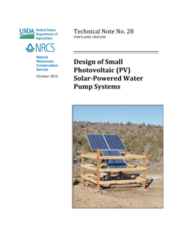
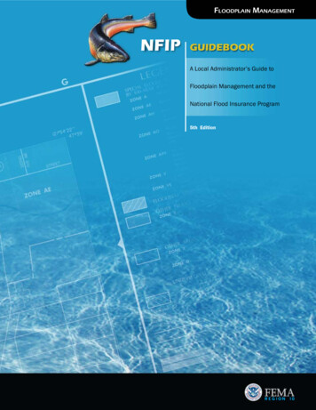
Flooding is a natural occurrencePeriodically, rivers, streams andlakes will overflow their banksand inundate adjacent landareas. These areas, known asfloodplains, temporarily storethis excess water. Flood damagesoccur only when man interfereswith the natural flooding process by altering the watercourse,developing areas in the upperwatershed, and/or buildinginappropriately in the floodplainitself.The traditional solution toflood problems has been tobuild structural protectionworks such as dams, diversions,levees and floodwalls. Despitetremendous expenditures forthese structural projects, economic flood losses have continued to increase year afteryear. Given this, governmentsat every level have begun to seethe solution to avoiding flooddamages lies not in keepingthe water away from people,but rather in keeping peopleaway from the water.This philosophicalshift lead to the creation of the NationalFlood Insurance Program (NFIP) in 1968,thereby codifying theconcept of floodplainmanagement.The basic purpose of theNFIP is not to prohibit floodplain development, butto guide developmentin floodplain areasin such a way as togreatly lessen the economic loss and socialdisruption caused byimpending flood events. Thepurpose of this guidebook is toassist local officials in their understanding of the NFIP and theFactA recent study showed thatonly 2% of the claims paidfor flood damages are forpost-FIRM structures (structures built after the dateof a community’s f loodmap and adoption of a local floodplain managementordinance), whereas 98% ofthe claims paid are for olderor pre-FIRM structures. Thisis strong evidence that theNFIP is successful at protecting new developments.Figure AFigure B1procedures that communitiesshould follow in administeringtheir floodplain managementordinances.Flooding isa natural occurrenceFloodplains are “built”by rivers (Fig. A). Flooddamages result whenpeople build on floodplains without takingthe river into account(Fig. B).
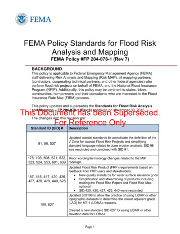
Chapter 1 - Floodplain Management ConceptsThe Base FloodThe base flood, sometimes referred to as the 100-year flood,has a 1% chance of occurringin any given year. Although a100-year flood sounds remote,keep in mind that over the lifeof an average 30-year mortgage,a home located within the 100-year flood zone (A or V zone)has a 26% chance of being inundated by the base flood. Thissame home has less than a 1%chance of fire damage duringthe same period.What is more significant isthat the house in this exampleis almost certain to see a 10year flood (96% chance) in thesame 30-year mortgage cycle.In many areas the difference inflood heights between a 10-yearand a 100-year event may be aslittle as one foot!Flood Frequency ChartFlood frequency(years)Chance of floodingin any given yearPercent chance of floodingduring 30-year mortgage1010 out of 100 (10%)96%502 out of 100 (2%)46%1001 out of 100 (1%)26%5000.2 out of 100 (0.2%)6%FloodwayThe floodway includes the channel of a river or stream and theoverbank areas adjacent to thechannel. The floodway carries the bulk of the floodwaterdownstream and is usually thearea where water velocities andforces are the greatest and mostdestructive. Regulations requirethat the floodway be kept openso that flood flows are not obstructed or diverted onto other roperties. Such obstrucptions or diversions can causeincreased damages withinthe floodway as well as inthe flood fringe (see diagrambelow).Characteristics of a FloodplainFloodplainFlood FringeFlood FringeFloodwayFillBase Flood Elevation (BFE)Normal Channel5
Base FloodElevation (BFE)Flood FringeThe BFE is the elevation (usually expressed in feet above sealevel) which the base flood isexpected to reach.The area on either side of thefloodway is called the floodfringe. This area is subject toinundation by the base floodbut conveys little or no velocityflows.Special Flood Hazard Area (SFHA)FillFor purposes of the NFIP, thearea that would be inundatedby the base flood is also calledthe special flood hazard area(SFHA), or simply the floodplain.plain development permit. Careshould be taken to ensure thatthe fill will not alter drainage, divert flood water to otherproperties or affect endangeredspecies or their critical habitat. Filling is prohibited in thefloodway.By nature, floodplains arelow-lying areas that seem toinvite filling activities. Filling is included under the NFIPdefinition of “development”and therefore requires a flood-The Effects of Fill on a FloodplainThis house never flooded before thefill was placed on the riverbank100 year flood after fill100 year flood before fill10 year flood after fill10 year flood before fill"Bank Full"The fill material displacesfloodwaters which raises theflood levels across and upstream.6
Chapter 2 - Mapping and Map RevisionsFloodplain MapsFloodplain maps are the basisfor implementing floodplainregulations. The maps vary indetail depending on severalfactors, including the amountof historical data, the detail ofthe base topographic maps, theflood threat, and the floodplaindevelopment potential. Thereare basically three types offloodplain maps:any specific development sitewithin a community can usuallybe determined. More recentlypublished FIRMs include bothBFEs and regulatory floodways.Flood Hazard Boundary Map(FHBM)A very generalized map usually issued to a communitywhen they first join the NFIP.FHBMs do not include BaseFlood Elevations (BFEs).Only a handful of communities still possess thesebasic flood maps.Flood InsuranceRate Map (FIRM)Most communities havea FIRM. They generallyinclude BFEs and showflood zones, AppendixA, and are based ona detailed study offlood potential in thecommunity. Withthe FIRM, flood elevations atThe year 2009 marks the end ofFEMA’s Map Modernization program (MapMod) and the beginning of FEMA’s new Risk MAP(Mapping, Assessment and Planning) program. While the mapmodernization program provided digital Flood Insurance Rate Maps (dFIRMS)for approximately 97% ofthe population, Risk Mapwill enhance the accuracyof these maps with updated, more detailed data andcreate new dFIRMS in areasthat were not mapped ornot studied during MapMod.Risk MAP encourages expansion beyond the conventionalregulatory applications of floodhazard data to broader non-regulatory risk assessments for allhazards and the incorporationof Risk MAP data and productsinto the planning process.Flood Boundary andFloodway MapThese maps delineate floodwaysbut do not give BFEs or floodzones. A community must useits FIRM to identify BFEs. NewerFIRMs eliminate the dual maps;all information, including floodways, is on the newer FIRMs.The Flood Insurance StudyThe Flood Insurance Study(FIS) is conducted by FEMAto determine the flood hazard present in the community as well as the flood zonesthat will be used to writeflood insurance. The data inthe FIS is used to producethe flood maps mentionedabove. The FIS providesdetailed and accurate floodhazard information thatincludes a written reportcontaining a description of a9community’s flooding conditions, and flood profilesshowing the 500, 100, 50and 10-year flood elevationsfor each stream reach studied in detail. The followingexplains the two types ofstudy approaches used:
ApproximateThe approximate study,depicted as zone A on theFIRM, delineates the “100Year” floodplain boundaries. The boundaries are established by reviewing existing data such as a FloodHazard Boundary Map,USGS Flood-Prone Quadrangle Map, US Army Corpsof Engineers FloodplainInformation report, andother historical data, andtransferring this information to the FIRM. If no existing data is available, thena rough hydrologic analysisis performed to determinethe width of the floodplain.The approximate studygenerally involves little orno field work. The baseflood elevation or depthsare not determined. Theseareas are also referred to asunnumbered A-Zones.Floodplain Map Studies and RestudiesPeriodically, FEMA, in consultation with our State partners,conducts floodplain studies andrestudies to update a community’s FIRMs. FEMA’s decisionto conduct a flood study or torestudy a particular stream isbased on numerous variables,including funding availability,local community desire for astudy/restudy, evidence that theexisting flood hazard data is inaccurate, development potential,and NFIP policies in force.DetailedThe detailed study usesconsiderably more specifichydrologic and hydraulicengineering methods. Thedetailed study is depictedas numbered A zones(A1-A30), AE, AH, and AOzones. Detailed surveys areconducted in the field foruse in the hydrologic andhydraulic analyses. The datafrom cross sections of thefloodplain are used as inputto a mathematical model(HEC-2 or HEC-RAS) thatcomputes the base floodelevations. A detailed studyoften will include delineation of a floodway and the500-year floodplain.10Usually following a requestfrom local officials, FEMA willconduct a scoping meeting todetermine general study/restudyneeds. Then, at a Time and Costmeeting, local officials meetwith FEMA staff and the FEMAstudy contractor to discuss specific study/restudy issues. Aftera study contractor completesthe flood study (a process thatcan take from a few months toa few years), the following stepsare taken, leading ultimately to
a new effective FIRM for your community:1 Draft FIS/FIRM and Technical Study Data Notebook,completed by the study contractor, is delivered to FEMA2 Draft data is reviewed byFEMA and Map CoordinationContractor3 Preliminary FIS/FIRMis delivered to localcommunity(ies)4 Final Coordination Meeting,involving local communityrepresentatives, FEMA, andstudy contractor, is held withthe public5 Notice of Start of Appealsperiod appears in local newspaper6 90-day Appeals Period commences7 90-day Appeals Period ends8 Appeals are adjudicated9 Letter of Final DeterminationReview is sent to communities (FIRMs will be effectivein 6 months)Typical Flood Insurance Rate Map (FIRM)Map RevisionsSometimes it is necessary forfloodplain data to be revised. Inmost instances, FEMA will notrepublish an entire map, butwill simply issue a letter thatdescribes the revisions. Revisions to an individual flood mappanel are generally made forone or more of the followingreasons:10 Community must updatetheir ordinances within the6-month adoption period Revisions to correct a minorerror11 Final “Official” FIS/FIRMsare delivered to communities, which must amendflood ordinance to reflectnew maps Revisions based on authorized filling in the floodplain Revisions based on betterground elevation data Revisions based on betterflood data Revisions based on newflood worksThere are three main types ofmap revisions.111. Letter of Map AmendmentA Letter of Map Amendment,or LOMA, is a procedure inwhich FEMA reviews technical data submitted by theproperty owner who believesa property or structure wasincorrectly included withina designated flood hazardarea (MT-1 Form). A LOMAamends the current floodplain map and establishesthat the property or structureis not located within a specialflood hazard area.LOMAs are used to verify thatnatural ground elevations areabove the base flood elevation (BFE). LOMAs can waivethe flood insurance requirement for loans if acceptedby the lender. An ElevationCertificate (EC) supports aLOMA but, by itself, doesnot remove the insurancerequirement.
2. Letter of Map RevisionBased on Fill (LOMR-F)A LOMR-F removes landfrom the SFHA that has beengraded or filled (physicalchanges) since the date theflood map was issued. (MT-1Form). Communities mustconcur with requests beforea LOMR-F is approved byFEMA. LOMR-Fs also canwaive the flood insurance requirement for loans. LOMRF requests have communitiescertify that the property orstructure(s) are reasonablysafe from flooding.LOMAInformationTo receive an MT-1form packet (LOMA/LOMA-F) or to check thestatus of a LOMA/LOMAF, please call the FEMAMap Assistance Centerat 1-877-FEMA-MAP. Youalso can download thepacket from FEMA’s website: www.FEMA.gov.3. Physical Map Revision(LOMR PMR)Any map revision otherthan one showing a simple,authorized fill, such asa new or altered bridge,culvert, channel, levee, orberm; changes in hydraulicor hydrologic conditions;or any combination thereof; requires an engineeringanalysis (MT-2 Form).How is a LOMA/LOMR-FIssued?Requests for LOMAs andLOMR-Fs must be submittedon forms provided by FEMA,which include the followinginformation: Property Information Form- may be completed byproperty ownerLOMA/LOMR-F requests for both singleand multiple lots are submitted to FEMA Headquarters in WashingtonD.C. and take 3 to 6 weeksto process.For questions on howto complete the forms,please call FEMA Map Assistance Center (FMAC)at 1-877-FEMA MAP (1877-336-2627).12 Elevation Information Form- must be completed by alicensed engineer or landsurveyor Summary of Elevations (Individual Lot Breakdown Form)- must be completed by anengineer or land surveyor ifmore than one lot is involved Community Acknowledgment Form - used for LOMRFs completed by community Certification of Fill Compaction Form - used for LOMRFs greater than a single lot,completed by an engineer orcommunity official
Chapter 3 - The National Flood Insurance ProgramTo participate in theNational Flood InsuranceProgram (NFIP), a community must adopt and enforcea floodplain management ordinance that regulates developmentin the community’s floodplain.The fundamental objectives ofthe NFIP are (1) to ensure thatnew buildings will be free fromflood damage, (2) to preventnew developments from increasing flood damages on existingproperties and (3) to ensure thatnatural and beneficial functionsof floodplains are maintainedor restored when opportunitiesarise. It should be noted that theNFIP is but one component of acommunity’s floodplain management program.HistoryThe National Flood Insurance Program was created by Congressin 1968 to minimize the ever rising disaster relief costs and toreduce the loss of life and property caused by flooding. TheProgram has four goals:1 Provide affordable flood insurance coverage not generallyavailable in the private m arket.2 Stimulate local floodplain management to guide future development.The Community Assistance Visit (CAV)3 Emphasize less costly nonstructural flood control regulatorymeasures over structural measures.Periodically, the Federal or Stateflood insurance coordinator(s)will visit your community toconduct a Community Assistance Visit (CAV). The purposeof the CAV is to assist the localfloodplain coordinator andother local officials in enforcing the community’s floodplainmanagement ordinance.The CAV also seeks to evaluate the local floodplain management program in relation to theregulations governing the NFIP.A CAV includes the following:a meeting with local staff todiscuss procedures used in issuing development permits and toreview permit files; a check ofbuilding permits and elevationdocumentation to see if newdevelopment is being regulatedaccording to the requirements4 Reduce Federal disaster costs by shifting the burden from theall taxpayers to floodplain occupants.of the local code; and a tour ofthe flood hazard areas. A followup letter is sent to the chiefelected official, and a report isfiled with the Federal Emergency Management Agency on thefindings of the visit.During a typical NFIP CAV,the following issues are oftenidentified:Record Keeping SystemsRecord keeping systems shouldbe adequate to ensure that elevation records and requirementsare communicated prior to construction and maintained properly so that subsequent buyerswill not have to pay for another15elevation survey. Floodplain development records are requiredto be retained in perpetuity.Permits for“Other Development”Many communities, althoughthey have adequate floodplainmanagement ordinances, do nothave a permit process to coverall “other development”, whichincludes activities such as mining, drilling, dredging, grading,paving, excavations, and fillingin flood hazard areas.As-Built Elevation CertificatesCommunities often do notsecure as-built certifications of
About Flood Insurance Federal flood insurance is available only in thosecommunities that participate in the National FloodInsurance Program (NFIP). In order to receive Federal disaster assistance inidentified floodplains,communities mustparticipate in, and be ingood standing with, theNFIP.the lowest floor elevation of astructure. Elevation documentation based on plans and drawings is insufficient to ensure thatthe lowest floor has indeed beenbuilt above the BFE.Definition of Lowest FloorThere is often misunderstandingregarding space below the lowest floor. See the definition ofLowest Floor in theGlossary.FloodwayEncroachment Flood insurance isrequired for federallybacked loans topurchase or buildstructures locatedin any special floodhazard area.All encroachments,including fill, newconstruction, andsubstantial improvements within theregulatory floodwayare prohibited, unlessan engineering no-riseanalysis is done. Flood insurancecan be purchased fromany agent whois licensed towrite propertyand casualty insurance.FloodproofingOnly non-residentialstructures can be floodproofed, and then only dryfloodproofed (water tight). Flood insurance can be purchasedfor any walled or roofed building anywhere ina participating community regardless of the mappedflood zone in which the structure is located. The NFIP covers structural elements, essential equipment, and other basic items located in a basement. Rates are subsidized for Pre-FIRM buildings; they areactuarial rates for Post-FIRM structures. There is a waiting period of 30 days before coveragegoes into effect. There is no waiting period whentitles of properties are transferred to new owners.16Alteration of WatercoursesAlthough there is no prohibition against altering watercourses (except in a designated floodway), there is a requirement tonotify adjacent communities,the State Coordinating Agency,and FEMA.Mobile Home AnchoringAll mobile homes placed in aflood hazard area, includingthose in existing mobilehome parks, are required tobe anchored to a permanentfoundation that will resist
flotation and lateral movement.Public Information (300 series)NOTE: Chapter 5 of this Guidebook “NFIPFloodplain Development Standards” providesa detailed explanation of each of the issueslisted above.This series credits programs thatadvise people about the floodhazard, flood insurance, andways to reduce flood damage.The CommunityRating System (CRS)The NFIP’s Community RatingSystem (CRS) recognizes community floodplain managementefforts that go beyond the minimal requirements of the NFIP byreducing flood insurance premiums for the community’s property owners. Discounts to premiums range from 5% to 45%.The new (2007) goal of CRS is toreduce flood damage to insurableproperty by strengthening andsupporting the insurance aspectsof the NFIP, and encouraginga comprehensive approach tofloodplain management.The CRS recognizes 18 floodplain management activitiesdivided into four series:Effects On LendersThe purchase of flood insurance applies to all mortgageproperties that fall underone of the following threecriteria: the owner is applying for a federally backed(VA, FHA, etc.) loan; thelending institution is federally regulated; or the loanwill be sold on the secondary market to a GovernmentSponsored Enterprise (GSE)such as Fannie Mae or Freddie Mac. This compriseswell over 95% of all mortgage loans made each year.Mapping & Regulations(400 series)This series credits programs thatprovide increased protectionto new developments. Theseactivities include mapping areasnot shown on the FIRM, preservation of open space, and restoration of natural and beneficialfunctions of the floodplain.Flood Damage Reduction(500 series)This series credits programs forareas in which existing development is at risk. Credit is provided for a comprehensive floodmitigation plan, relocating,elevating or retrofitting floodprone structures, and for maintaining drainage systems.The lender must first determine whether the structure is in a Special FloodHazard Area (SFHA). Thisis done using an approvedStandard Flood Hazard Determination Form.For all properties locatedin an SFHA, lenders mustrequire flood insurancewhen making, increasing,extending, or renewing aloan. This requirement applies only when the structure is in the SFHA, not thelot. Lenders must ensurethat coverage remains ineffect for the life of the loan.A GSE such as Fannie Mae17Flood Preparedness(600 series)This series credits flood warning, levee maintenance and damsafety programs.Increased Cost ofCompliance (ICC)ICC coverage provides for thepayment of a claim for the costto comply with State or community floodplain managementlaws or ordinances after a directphysical loss by flood. When abuilding covered by a StandardFlood Insurance Policy underthe NFIP sustains a flood lossand the community declaresthe building to be substantiallydamaged, ICC will help pay upto a maximum of 30,000 of thecost to elevate, floodproof, demolish, or relocate the structure.or Freddie Mac must ensurethat any loans they purchasehave flood insurance, ifrequired.If a loan has escrows fortaxes, insurance, or for anyother reason, the lendermust also escrow for floodinsurance. Lenders arerequired to notify borrowers if their building is inan SFHA and that they have45 days to purchase floodinsurance. After 45 days,lenders have the statutoryauthority to force purchaseof flood insurance. If a borrower believes the floodzone determination was inerror, the borrower and thelender must jointly requesta review from FEMA, withappropriate supporting technical information.
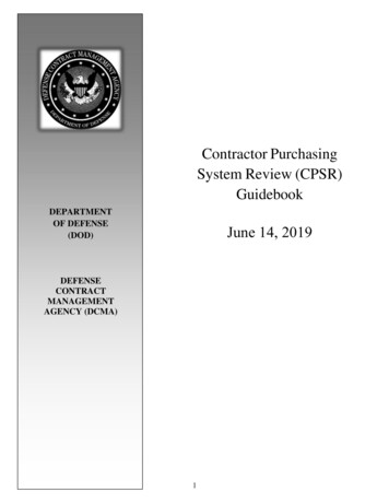
Flood Insurance Requirements forResidential Sites in Special Flood Hazard AreasExample AExample EProperty in SFHA butstructure is not.Insurance notrequired.Structure in SFHA butsubstantially elevated onnatural knoll. Lendermust require insurance.Builder can request Letterof Map Amendment(LOMA).Ri v e rExample BStructure located in SFHAalthough on high bluff.Lender must requireinsurance but buyer canrequest LOMA. Uponapproval of LOMA, buyermay receive insurancerefund.Example FStructure in SFHA butsubstantially elevated on fill.Insurance initially required,but buyer can requestLOMR-F. Insurance maybe refunded.Example CStructure partiallylocated in SFHA.Insurance alwaysrequired.Example GStructure in SFHA butelevated through meansother than fill, e.g. posts,pilings, piers, etc.Insurance alwaysrequired.Example DStructure located inSFHA but notelevated. Insurancealways required.Special FloodHazard Area18
Chapter 4 - Floodplain Management at the Local LevelA Community’s Responsibilitiesunder the NFIPThe management of the NFIPin a community consists of apartnership between the Federal government and the localcommunity. The responsibilitiesof the local community are asfollows: Require watersupply systemsbe d esignedto eliminateinfiltrationof floodwaters. Require development permits for all proposed construction and other developments within the community’s designated 100-yearfloodplain. Requirenewand replacementsanitarysewage systems bedesigned to minimize oreliminate infiltration offlood waters. Ensure all other permitsrequired by local, State andFederal laws are obtained. Maintain records of all development permits. Review the permit to ensurethat sites are reasonably safefrom flooding. Review subdivision proposals to determine whether theproject is safe from floodingand provides for adequatedrainage. Require residential structuresto have the lowest floor (including basement) elevatedat least to or above the BaseFlood Elevation (BFE). Require non-residentialstructures to have the firstfloor elevated or floodproofed one foot above theBFE. Require manufactured homesbe elevated and anchored. Ensure flood carrying capacity of altered or relocatedwatercourses is maintained. Verify/document lowestfloor elevations of new orsubstantially improved structures. Determine whether structures in the SFHA have beensubstantially damaged. (SeeGlossary for definition ofSubstantial Damage.) If asubstantial damage determination is made, the repairsmust include bringing thestructure up to current floodhazard area building standards.NOTE: In Washington, damage tomanufactured homes is inspected bythe State Department of Labor and Industries (other states may have similarrequirements) so that local officials mustcoordinate this effort with their regionalL&I offices.218StepsThe followingare steps onhow to properly review aFloodplain Development Permit Application:1Locate the development site on thecommunity’s floodplainmap. If the project site isobviously outside the shadedA-Zone or V-Zone, then floodplain regulations do not apply.If the project site is in a shadedA-Zone or V-Zone (or is a borderline question), proceed tothe next step.2Ensure project meets theNFIP/local ordinancedefinition of “development.”See the next page for the typeof activity that is considereddevelopment. As a generalrule, anything that alters thenatural topography of thefloodplain needs a permitreview. Please be advisedthat development does notinclude: maintenance of existing buildings and facilities;resurfacing of roads; gardening, plowing and similaragricultural practices that donot involve filling, grading orconstruction of levees.
3Have the owner/developer fill out a local Building Permit Application. Alocation or plat map of thesite should be attached to every application form. Plans ofthe proposed development,showing existing and proposed conditions includingall appropriate dimensionsand elevations, should also beattached. Check to see if thesite is located in the regulatoryfloodway by measuring thefloodway width on the Floodway Map and comparing thisdistance to the proposed project’s actual ground location.Development cannot occurin any floodway without a detailed analysis from a licensedengineer and/or hydrologistproving that the developmentwill cause no-rise in the baseflood elevation.4Check to see if the projectincludes a new buildingor a substantial improvement of an existing building.A “building” is a structure thatis principally above groundand is enclosed by walls and aroof including manufacturedhomes and prefabricatedbuildings. The term also includes recreational vehiclesand travel trailers to be installed on site for more than180 days.When a Pre-FIRM buildingis proposed to be remodeled,renovated, rehabilitated, added to or in anyway improved,the proposed modificationsmust be evaluated for “substantial improvement”. If thetotal costs of the improvementare 50 percent or more of thebuilding value, the buildingmust be elevated above theBFE. If the project includes anew “building” or “substantialimprovement,” go to Step 5.The Development PermitCommunities participating in theNFIP must require developmentpermits (Appendix B) for all proposed developments within thedesignated 100-year floodplain.The permit, along with all development plans, must be submittedfor approval to the appropriatelocal authority before beginningany development activity. Usuallythis authority is the local floodplain administrator.What Information Should thePermit Contain?When Is a DevelopmentPermit Required? Description of proposed activityAll development within theregulatory floodplain requires apermit. Development includes: New construction or a substantially improved structureIn addition to obvious information, such as the applicant’sname, address, and phonenumber, a development permitshould also contain the following information: The location of the proposeddevelopment A site map Elevation of ground site priorto development Elevation to which lowest floorof the structure must be built Placing a manufactured (mobile) home Elevation to which structurewill be flood-proofed (nonresidential only) Mining, dredging, filling,grading or excavating Base flood elevation (BFE)data for subdivisions Roads, bridges and culverts Description of water coursealterations Altering or relocating streamchannels Travel trailers placed on sitefor more than 180 days Storage of materials includinggas or liquid storage tanks A space for approving ordenying the permit A space for signature anddateDuties of the Floodplain AdministratorThe duties of the local floodplain administrator (FPA) arequite varied. One task is thereview and evaluation of development permit applications. Reviewing and evaluating permitsinvolves several steps, including: Checking applications forcompleteness Making permit applicationsavailable to prospective developers Determining BFE for the proposed development site22 Checking development locations on floodplain maps Determining if developmentaffects the floodway Establishing first floorelevations
Requiring additionalFederal/State/Local permitsfloor elevation. The lowest floorelevation must be checked before framing of the development Determining if watercoursestructures begins. The FPA mustalterations will reducealso ensure that c
Risk MAP encourages expan-sion beyond the conventional regulatory applications of flood hazard data to broader non-reg-ulatory risk assessments for all hazards and the incorporation of Risk MAP data and products into the planning process. Flood Boundary and Floodway Map These maps delineate floodways but do not give BFEs or flood zones.