Transcription
Valley South Subtransmission ProjectC.13 RECREATIONC.13RecreationIntroductionThis section describes effects associated with recreation that would be caused by implementation of theVSSP. The following discussion addresses existing environmental conditions in the affected area, identifiesand analyzes environmental impacts for the proposed Project, and recommends measures to reduce oravoid significant impacts anticipated from Project construction, operation, and maintenance. In addition,existing laws and regulations relevant to recreation are described. In some cases, compliance with theseexisting laws and regulations would serve to reduce or avoid certain impacts that might otherwise occurwith the implementation of the proposed Project.Scoping Issues AddressedDuring the scoping period for the EIR (May 5 through June 8, 2015), written comments were receivedfrom agencies, organizations, and the public. These written and verbal comments identified varioussubstantive issues and concerns relevant to the EIR analysis. No issues related to recreation were raisedduring scoping.C.13.1Environmental SettingThe affected environment for this analysis describes existing environmental conditions that contribute torecreational resources at the time of publishing the Draft EIR (January 2016). The Project area can becharacterized as low-density urban with areas of rural development. For the purposes of this analysis, therecreation study area has been defined as the area within half mile from either side of the centerline ofthe existing right-of-way (ROW) or other Project components. This is an appropriate study area forrecreation because impacts to recreational resources (refer to Table C.13-1 below) would be morelocalized to the low-density development as opposed to remote, open desert areas. These recreationopportunities contribute to baseline conditions and could potentially be affected by activities related tothe Project.The Project consists of Segments 1 and 2 and is 15.4 miles in total length. It is located withinunincorporated Riverside County and the cities of Menifee, Murrieta, and Temecula. Segment 1 of theProject involves construction of a new 115-kV subtransmission line originating at SCE’s existing Valley500/115-kV Substation and connecting at a tubular steel pole (TSP) located at the southeast corner ofLeon Road and Benton Road, for a total of 12 miles. Segment 1 of the Project would cross through the Cityof Menifee, unincorporated Riverside County, and a small portion of the City of Murrieta. Segment 2 ofthe Project involves reconductoring a section of the existing Valley-Auld-Triton 115-kV SubtransmissionLine, and begins at the TSP located at the southeast corner of Leon Road and Benton Road and continuessouth to the existing Terminal TSP located on the south side of Nicolas Road, for a total of 3.4 miles.Segment 2 would cross through unincorporated Riverside County and the City of Temecula. Additionally,SCE may utilize an existing material staging yard outside of Segments 1 and 2 in the City of Perris.Final EIRC.13-1June 2016
Valley South Subtransmission ProjectC.13 RECREATIONTable C.13-1. Recreational Facilities within One Mile of the ProjectJurisdiction/AdministrationRiverside CountyDistancefromProject(miles)0.07Riverside County1Discovery ParkRiverside County0.35Overlook ParkRiverside County0.31Joseph ParkCentral ParkRiverside CountyRiverside County0.320.11Amphitheatre ParkHeritage ParkEller ParkRiverside CountyCity of MenifeeCity of Menifee0.30.650.87Marion V. AshleyCommunity CenterCity of Menifee0.68Northstar ParkCity of Murrieta0.64Nicolas Road ParkCity of Temecula0.92Voorburg ParkNakayama ParkCity of TemeculaCity of Temecula0.820.31Riverton ParkSheffield ParkCity of TemeculaValley-Wide Recreationand Park DistrictValley-Wide Recreationand Park DistrictValley-Wide Recreationand Park DistrictValley-Wide Recreationand Park DistrictValley-Wide Recreationand Park DistrictValley-Wide Recreationand Park DistrictValley-Wide Recreationand Park DistrictValley-Wide Recreationand Park DistrictValley-Wide Recreationand Park DistrictValley-Wide Recreationand Park DistrictValley-Wide Recreationand Park eloped County regional park, closed togeneral publicBasketball courts, baseball field, playground,gazebos, barbeque area, trails, and dog parkTree house playground and separate playground fortots, basketball courts, soccer field, gazebos, picnicbenches, barbeques, and trailsPassive park that includes landscaping andbenchesBasketball courts, walking paths, and gazebosLighted tennis court, sand volleyball court, openfields, a canopy shaded playground, walking paths,benches, and a gazeboOpen grass areas, walking paths, and benchesBasketball courts, play areas, and picnic areasLighted ball field, basketball courts, running/joggingtrack, playground equipment, and restroomsGymnasium lighted ball fields, basketball courts,volleyball court, play area, picnic area, fitness trails,and restroomsOpen grass areas, barbeques, picnic tables,shelters, softball fields, tot lot, and water fountainsBasketball court, children’s play area, barbeque,picnic tables, and benchesOpen grass area, barbeque, and picnic tablesBasketball court, children’s play area, barbeque,picnic tables, and sheltersChildren’s play area, barbeque, and picnic tablesBall fields, soccer fields, and fitness trails0.75Ball field, basketball courts, and a play area0.58Volleyball court, play area, picnic area0.37Play area0.32Play areas, baseball fields, a picnic area, and asoccer fieldPicnic area, baseball field, fitness trails, basketballcourts, a volleyball court, and a play areaPicnic area, basketball courts, play areas, andfitness trailsBasketball courtRecreational FacilityDouble Butte CountyRegional ParkWillows ParkEmerald ParkPrimrose ParkKona ParkSpencer’s CrossingBrookfield Open Spaceand Brookfield ParkLeon ParkAvignon ParkCrown Valley ParkWhispering HeightsParkFrench ValleyStreetscapesJune 20160.910.050.470.670.78Lighted ball fields, soccer fields, basketballcourts, tennis courts, and play areasPlay area0.17Landscaping and open grass areaC.13-2Final EIR
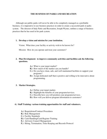
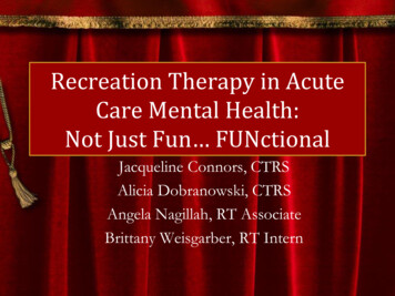
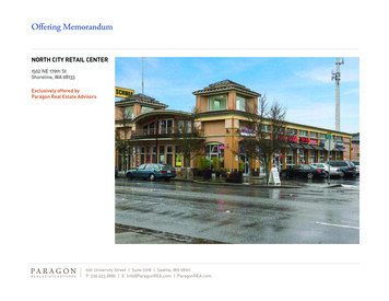
Valley South Subtransmission ProjectC.13 RECREATIONTable C.13-1. Recreational Facilities within One Mile of the ProjectRecreational FacilityFrench ValleyCommunityCenter & Park (alsoreferred to as theRancho Bella VistaCommunity Center andPark)Watermill ParkSource: SCE, e Recreationand Park DistrictValley-Wide Recreationand Park ion/Uses/FacilitiesGymnasium, lighted ball fields, basketball courts,play areas, picnic areas, and restroomsOpen grass areas, walking paths, and benchesRecreation Resources within the Vicinity of the ProjectThe proposed Project crosses portions of unincorporated Riverside County, which contains several parks,trails, and recreation facilities. The proposed Project is also located within one mile of a private golfcourse. Currently Riverside County maintains 35 regional parks and four park and recreation districts.County recreational facilities include ball fields, equestrian facilities, trails, and cultural facilities. Nofederal parks or State recreation areas are located within a one-mile vicinity of the proposed Project area.Additionally, the cities within Riverside County maintain approximately 215 parks. Private recreationalfacilities, such as tennis/basketball courts, pools/spas, and/or playgrounds, can be found primarily inplanned communities and apartment complexes. The locations of parks and recreation facilities near theproposed Project are shown on Figure C.13.1 (4.15-1 Parks and Recreational Areas). Table C.13-1 (Parksand Recreational Facilities within One Mile of the Proposed Project) presents information on parks orrecreational facilities located within one mile of the proposed Project. These recreational facilities aredescribed below, by county and city jurisdiction.Riverside CountyThe following is a brief description of the Riverside County regional and community parks located in thevicinity of Segments 1 and 2 of the proposed Project. Double Butte County Regional Park. This park consists of a steep, dual-peaked mountain located east ofthe proposed Project. Much of this feature was the site of a county landfill, which has since been closed.The County Regional Park is 400 to 600 acres and encompasses a limited portion of the larger physicalfeature of Double Butte Mountain. This former landfill area is currently an undeveloped County RegionalPark that is closed to the general public (SCE, 2014). The county intends to establish recreational uses atDouble Butte County Park once clean-up and mitigation measures have been completed in connection withthe closure of the landfill (County of Riverside, 2014a). The western portion of Double Butte Mountain,outside of the County Regional Park area, is currently used for passive recreation, which includes informalrock climbing and bouldering use (Mountain Project, 2012). Willows Park. This park is located at 29750 Willows Avenue in unincorporated Riverside County, east of theCity of Murrieta. This park is located east of the proposed Project area, encompasses 8.5 acres, and includesbasketball courts, a baseball field, a playground, gazebos, barbeque area, trails, and a dog park (RiversideCounty Parks, 2014; Riverside County Economic Development Agency, 2009).Final EIRC.13-3June 2016
Valley South Subtransmission ProjectC.13 RECREATIONINTENTIONALLY LEFT BLANKJune 2016C.13-4Final EIR
.,, ' 'O .: . :Valley South Subtransmission ProjectC.13 RECREATION:------,! .- .::.::,: . -·:···----·-----------:::., ::·m."CITY OFHEMETRO' -ti 4th StMclaughlin Rd4Perris Staging Yard(5.6 Miles NW of Valley Substation)No parks within 1 mileMc6all BlvdSimpso Rd\.GITY0FMENIFEE.Sc0tt t;d Scott ······:;.,· ---.,.-- - .-.jCliTY OFWILDOM RClinton Keith RdULD SUBSTATICITY OFMURRIETABorel RdProposed 115 kV Subtransmission LineCommon to BothAlternative 115 kV Subtransmission LinePotential Material Staging Yards Staging Yards 1-6Existing FacilitiesParks and Recreational Areas115 kV Substation. 500 kV Substation ParksL.Salt Creek Trail Bikeway SystemTerminal TSPTransmission LineSubtransmission LineC 1 Mile Distance from Proposed Project1 Mile Distance from Alternative ProjectSource: SCE, 2014.Final EIRC.13-50Miles1 :80,000Figure C.13-1Parks andRecreational AreasJune 2016
Valley South Subtransmission ProjectC.13 RECREATIONINTENTIONALLY LEFT BLANKJune 2016C.13-6Final EIR
Valley South Subtransmission ProjectC.13 RECREATION Discovery Park. This park is located at 35100 Willows Avenue (along a natural gas line easement betweenWillows Avenue and Murrieta Hot Springs Road) in unincorporated Riverside County, east of the City ofMurrieta (Riverside County Parks, 2014; Riverside County Economic Development Agency, 2009). This parkis located east of the proposed Project, encompasses approximately 2 acres, and includes a tree houseplayground and separate playground for tots, basketball courts, a soccer field, gazebos, picnic benches,barbeques, and trails (Riverside County Parks, 2014). Overlook Park. This park is located at 29655 Joseph Road (along the north end of Joseph Road and behindNicolas Elementary School) in unincorporated Riverside County, east of the proposed Project (RiversideCounty Parks, 2014; Riverside County Economic Development Agency, 2009). This is a passive park thatencompasses approximately 3 acres and includes landscaping and benches (Riverside County Parks, 2014). Joseph Park. This park is located at the northwest corner of Nicolas Road and Joseph Road (generallybounded by an SCE easement between the City of Temecula’s Nakayama Park and Riverside County FloodControl bike path) in unincorporated Riverside County, east of the proposed Project (Riverside County Parks,2014; Riverside County Economic Development Agency, 2009). This park encompasses approximately 1 acreand includes basketball courts, walking paths, and gazebos (Riverside County Parks, 2014). Central Park. This park is located at 30666 Central Park Drive located in unincorporated Riverside Countybetween the City of Murrieta and Mount San Jacinto, east of the proposed Project (Riverside County Parks,2014; Riverside County Economic Development Agency, 2009). This park encompasses approximately 5acres and includes a lighted tennis court, a sand volleyball court, open fields, a canopy shaded playground,walking paths, benches, and a gazebo (Riverside County Parks, 2014). Amphitheatre Park. This park is located on the south side of Willows Avenue along a Sempra gas lineeasement in unincorporated Riverside County, east of the proposed Project (Riverside County EconomicDevelopment Agency, 2009). This park encompasses approximately 2 acres and includes open grass areas,walking paths, and benches (Google Earth, Pro, 2012 and 2014).City of MenifeeThe following is a brief description of the City of Menifee parks located in the vicinity of the proposedProject. Heritage Park. This park is located at McCall Boulevard and Heritage Lake Drive in the northeast area of theCity of Menifee, west of the proposed Project. This park encompasses 5.5 acres and includes basketballcourts, play areas, and picnic areas (Valley-Wide Recreation and Park District, 2015a). This park is currentlyadministered by the Valley-Wide Recreation and Park District (City of Menifee, 2014). Eller Park. This park is located at 25926 Antelope Road in the City of Menifee, northwest of the proposedProject. This park encompasses 5 acres and includes a lighted ball field, basketball courts, running/joggingtrack, playground equipment, and restroom facilities (Valley-Wide Recreation and Park District, 2015a). Thispark is currently administered by the Valley-Wide Recreation and Park District (City of Menifee, 2014). Marion V. Ashley Community Center. This center is located at 25625 Briggs Road in the City of Menifee,north of the proposed Project. This center encompasses 12 acres and includes a gymnasium, lighted ballfields, basketball courts, volleyball court, play area, picnic area, fitness trails, and restrooms (Valley-WideRecreation and Park District, 2015a). This park is currently administered by the Valley-Wide Recreation andPark District (City of Menifee, 2014).City of MurrietaNorthstar Park is located at 36728 Pictor Avenue in the City of Murrieta, east of the proposed Project(MapQuest, 2015). This park encompasses approximately 14 acres and includes, open grass areas,Final EIRC.13-7June 2016
Valley South Subtransmission ProjectC.13 RECREATIONbarbeques, picnic tables, shelters, softball fields, tot lot, and water fountains (City of Murrieta, 2014; Cityof Murrieta, 2011a; Google Earth, Pro, 2012 and 2014).City of TemeculaThe following is a brief description of the City of Temecula parks located in the vicinity of the proposedProject. Nicolas Road Park. This park is located at 39955 Nicolas Road in the City of Temecula, southeast of theproposed Project area. This park encompasses 2.93 acres and includes a basketball court, children’s playarea, barbeques, picnic tables, and benches (City of Temecula, 2014). Voorburg Park. This park is located at 39960 Nicolas Road in the City of Temecula, southeast of the proposedProject. This park encompasses 0.75 acre and includes an open grass area, barbeques, and picnic tables. Nakayama Park. This park is located at 30592 Nicolas Road in the City of Temecula, southeast of theproposed Project. This park encompasses 0.28 acre and includes a basketball court, a children’s play area,barbeques, picnic tables, and shelters (City of Temecula, 2014). Riverton Park. This park is located at 30950 Riverton Lane in the City of Temecula, southwest of theproposed Project. This park encompasses 4.94 acres and includes a children’s play area, barbeques, andpicnic tables (City of Temecula, 2014).Valley-Wide Recreation and Park DistrictA number of neighborhood parks located within cities or unincorporated Riverside County communitiesare operated by the Valley-Wide Recreation and Park District. This district was founded in 1972 as a specialdistrict to focus on recreation and parks. The following is a brief description of the Valley-Wide Recreationand Park District’s parks in unincorporated Riverside County in the vicinity of the proposed Project area(Valley-Wide Recreation and Park District, 2015b). Sheffield Park is located at the corner of Genoa Street and Pourroy Road in Winchester, encompasses 14acres, and includes ball fields, soccer fields, and fitness trails. Emerald Park is located at the corner of Emerald Drive and Algarve Avenue in Winchester, encompassesseven acres, and includes a ball field, basketball courts, and a play area. Primrose Park is located at the corner of Cloche Drive and McCartney Drive in Winchester, encompassesthree acres, and includes a volleyball court, play area, and picnic area. Kona Park is located at Waimea Way in Winchester, encompasses one acre, and includes a play area. Spencer’s Crossing is located at Thompson Road and Leon Road in Winchester, encompasses 11.5 acres,and includes play areas, baseball fields, restrooms, a picnic area, and a soccer field. Brookfield Open Space and Brookfield Park are located at Winchester Road and Pourroy Road inWinchester and encompass a total of 74 acres (12 acres for the park and 62 acres for the open space). Thepark includes a picnic area, baseball field, fitness trails, basketball courts, a volleyball court, and a play area. Leon Park is located at the corner of Euclid Loop and Saguaro Drive in Winchester, encompasses five acres,and includes a picnic area, basketball courts, play areas, and fitness trails. Avignon Park is located at the corner of Avignon Road and Thompson Road in Winchester, encompasses0.5 acre, and includes a basketball court. Crown Valley Park is located at the corner of High Vista Drive and Shadetree Drive in unincorporatedRiverside County, encompasses seven acres, and includes lighted ball fields, soccer fields, basketball courts,tennis courts, and play areas.June 2016C.13-8Final EIR
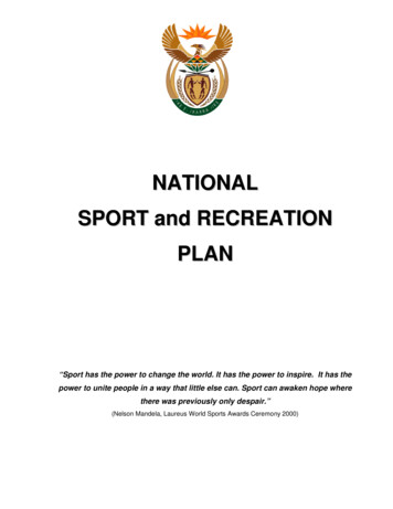
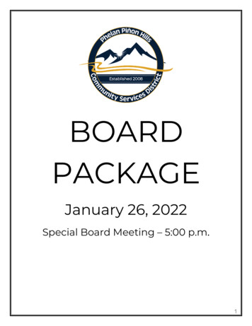
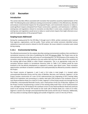
Valley South Subtransmission ProjectC.13 RECREATION Whispering Heights Park is located near the intersection of Pat Road and Slough Road in unincorporatedRiverside County and includes a play area. French Valley Streetscapes is located near the intersection of Perrine Street and Aaron Road inunincorporated Riverside County, and includes landscaping and open grass areas. French Valley Community Center & Park (also known as Rancho Bella Vista Community Center & Park) islocated at 31757 Browning Street in unincorporated Riverside County, encompasses seven acres, andincludes a gymnasium, lighted ball fields, basketball courts, play areas, picnic areas, and restrooms. Watermill Park is located at Spun Cotton Drive and Round Coral Drive in Winchester, encompasses oneacre, and includes open grass areas, walking paths, and benches.Other Recreational Areas Highland Palms Mobile Homes Golf Course is a private nine-hole golf course located 0.6 mile east of theproposed Project.TrailsRiverside County contains multi-purpose trails that accommodate hikers, bicyclists, and equestrian usersas an integral part of the county's circulation system. The cities of Murrieta and Temecula also containmulti-purpose trails and bike lanes (Class II bike lanes, which consist of paved bike lanes that follow arterialroadways) that accommodate hikers, bicyclists, and equestrian users as an integral part of the cities’circulation systems (City of Murrieta, 2011b; City of Temecula, 2005). Trails located in the vicinity of theproposed Project area are shown in Figure C.13-2 (4.15-2 Trail Locations). An existing regional trail runs along Briggs Road and Leon Road to Garbani Road, which would be locatedwithin one mile and parallel to the proposed Project. A Class I Bike Path exists from the intersection of Leon Road and Garbani Road, south to Benton Road; thisbike lane runs parallel to the proposed Project. A Class I Bike Path exists from the southeast corner of Leon Road and Benton Road, south to Murrieta HotSprings Road; this bike path runs parallel to the proposed Project. An informal community trail exists from the intersection of Chandler Drive and Murrieta Hot Springs Road,south to Nicolas Road; this informal community trail also runs parallel to the proposed Project.Trails that would be crossed by the proposed Project include: The Salt Creek Recreational Trail and levee road, which is an informal neighborhood walking path parallelto Old Leon Road (referred to as Old Leon Road in this analysis). The Salt Creek Recreation Trail/levee roadparallels Salt Creek (channelized in this area) and is located south of Olive Avenue. The Salt CreekRecreational Trail currently receives minimal use due to the lack of existing development in the area ittraverses. However, this trail is categorized as a Class I Bike Path/Regional Trail in the County of RiversideGeneral Plan and Harvest Valley/Winchester Area Plan. The walking path parallel to Old Leon Road is pavedand portions are landscaped; however, it is not an officially designated trail by the county (County ofRiverside, 2014b). During a site visit by SCE in February 2012, active recreational use of this trail wasobserved. A Class II Bike Lane along State Route (SR) 79, which is a paved bike lane located along SR-79 in the City ofMurrieta.Final EIRC.13-9June 2016
Valley South Subtransmission ProjectC.13 RECREATIONINTENTIONALLY LEFT BLANKJune 2016C.13-10Final EIR
Valley South Subtransmission ProjectC.13 RECREATIONaJr1p ,1RO' 41hSt., Q.zen0VJCITY OFHEMETE 4th St)34Mc@all Blvd!. CITY OFMENIFEE.,'u",,,,. ,,,,111 111 111 /fl"·c":;;CITY OFWILDOM RThompson RdCITY OFMURRIETABorel Rdt-···PAUBASUBSTATION-;/'.,,./.,,/Proposed ProjectProposed 115 kV Subtransmission LineCommon to BothAlternative ProjectExisting FacilitiesL. 115 kV Substation .500 kV SubstationTerminal TSP Staging Yards 1-60Miles1 :80,000Final EIR m Class 1 Bike Path/Regional Trail m Class 1 Bike Path Class 2 Bike Path (Murrieta)Transmission Line m Class 2 Bike Path (Temecula)Subtransmission LineRegional T railAlternative 115 kV Subtransmission LinePotential Material Staging YardsSource: SCE, 2014.Riverside County TrailsjCommunity Trail m Historic TrailC.13-11Figure C.13-2Trail LocationsJune 2016
Valley South Subtransmission ProjectC.13 RECREATIONINTENTIONALLY LEFT BLANKJune 2016C.13-12Final EIR
Valley South Subtransmission ProjectC.13 RECREATIONC.13.2Regulatory FrameworkThe Project would traverse through the sphere of influence of unincorporated Riverside County and thecities of Menifee, Murrieta, and Temecula. The following is a discussion of the federal, State, county, andlocal plans and policies that would be applicable to the proposed Project.C.13.2.1 FederalThere are no federal regulations related to parks and recreational facilities that would apply to theproposed Project.C.13.2.2 StateCalifornia Department of Fish and WildlifeThe mission of the California Department of Fish and Wildlife (CDFW) is to manage California’s diversefish, wildlife, and plant resources, and the habitats upon which they depend, for their ecological valuesand for their use and enjoyment by the public. This includes habitat protection and maintenance in asufficient amount and quality to ensure the survival of all species and natural communities. Thedepartment is also responsible for the diversified use of fish and wildlife, including recreational uses suchas fishing and hunting as regulated under CDFW codes.C.13.2.3 LocalCounty of Riverside General PlanMultipurpose Open Space Element Policy OS 20.2: Prevent unnecessary extension of public facilities, services, and utilities for urban usesinto Open Space-Conservation designated areas Policy OS 20.3: Discourage the absorption of dedicated park lands by non-recreational uses, public orprivate. Where absorption is unavoidable, replace park lands that are absorbed by other uses withsimilar or improved facilities and programsLand Use Element Policy LU 5.1: Ensure that development does not exceed the ability to adequately provide supportinginfrastructure and services, such as libraries, recreational facilities, transportation systems, andfire/police/medical servicesCity of MenifeeThe Open Space and Conservation Element does not contain any specific goals or policies relevant toelectric utility projects.City of MurrietaThe Recreation and Open Space Element does not contain any specific goals or policies relevant to electricutility projects.City of TemeculaThe Open Space/Conservation Element does not contain any specific goals or policies relevant to electricutility projects.Final EIRC.13-13June 2016
Valley South Subtransmission ProjectC.13 RECREATIONCity of PerrisThe City of Perris General Plan Open Space Element does not contain any specific goals or policies relevantto electric utility projects.C.13.3Applicant-Proposed MeasuresIn its Preliminary Proponent’s Environmental Assessment (PEA), SCE has listed a number of ApplicantProposed Measures (APMs) that are designed to reduce impacts from the proposed Project. Table C.13-2includes APM TRA-1, which applies to recreation.Table C.13-2. Applicant-Proposed Measures – RecreationAPMAPM TRA-1APM DescriptionTraffic control or other management plans would be prepared where necessary to minimizeproposed Project impacts on local streets, highways (State Route [SR]74 and SR-79), freeways,or other forms of transportation (Class I and Class II bicycle routes).Source: SCE, 2014 (PEA Table 3.13).C.13.4Environmental Impacts and Mitigation MeasuresRecreational facilities and opportunities in the area were evaluated to determine whether they would beadversely affected by the proposed Project. This evaluation included consideration of the overall numberand area of parklands or other recreational facilities and proximity (within one mile) to the proposed Project.C.13.4.1 Criteria for Determining SignificanceThe proposed Project would result in significant impacts to Recreation if it would: Criterion REC1:Increase the use of existing neighborhood and regional parks or other recreationalfacilities such that substantial physical deterioration of the facility would occur or beaccelerated. Criterion REC2:Include recreational facilities or require the construction or expansion of recreationalfacilities, which might have an adverse physical effect on the environment.C.13.4.2 Impact Analysis – Direct and Indirect EffectsImpact REC-1 (Criterion REC1): The Project could cause physical deterioration to existing neighborhoodand regional parks. (Class III)ConstructionProposed Project construction would be performed by either SCE construction personnel or contractors.SCE construction personnel would typically be based at SCE’s local facilities, (e.g., service centers,substation, transmission ROW) or at one of the six potential temporary material staging yards for theproposed Project. Contractor construction personnel would be managed by SCE and/or contractorconstruction management personnel and would be based out of the contractor’s existing yard or potentialtemporary material staging yard set up for the proposed Project. SCE anticipates approximately 67construction personnel working on any given day. Construction personnel may occasionally utilize parksfor lunch, but this would be a short-term temporary occurrence. Existing parks and recreation facilitieswithin the proposed Project area would have sufficient capacity to accommodate this potential minorincrease in use. Therefore, construction personnel would not cause physical deterioration to existingrecreational facilities and the impact would be less than significant (Class III).June 2016C.13-14Final EIR
Valley South Subtransmission ProjectC.13 RECREATIONOperation and MaintenanceO&M of the proposed Project would not introduce new population in the area that would increase theuse of any existing neighborhood or regional parks. The proposed 115-kV subtransmission and associatedcomponents and the reconductored Valley-Auld-Triton 115-kV subtransmission Line would be controlledremotely through SCE control systems and manually in the field as required. Maintenance personnel whomight visit the route from time-to-time may want to occasionally utilize a park for lunch, but this is likelyto be infrequent and would not represent a notable increase in user population. Therefore, operationpersonnel would not cause physical deterioration to existing neighborhood or regional parks and theimpact would be less than significant (Class III).Impact REC-2 (Criterion REC1): Construction or operation could cause physical deterioration to existingtrails, bike paths, or pedestrian sidewalks (Class II)ConstructionThe proposed Project would run parallel to or cross existing trails, Class I Bike Paths and Class II Bike Lanes,and pedestrian sidewalks. In areas where the proposed Project would run parallel to existing trails, ClassI Bike Paths and Class II Bike Lanes, and pedestrian sidewalks, it would not block or hinder the flow of bikeor trail traffic during construction. However, the proposed Project could result in temporary interruptionto existing trails, Class I Bike Paths and Class II Bike Lanes, and pedestrian sidewalks during construction.Several stringing (pulling, tensioning, and splicing) sites are proposed where a trail, bike path or bike lanewould cross between the poles or under the circuits. Construction activity would have short-term andtemporary effects on these existing bike paths and trail. SCE would implement APM TRA-1 to reducepotential impacts related to Class I Bik
Nicolas Elementary School) in unincorporated Riverside County, east of the proposed Project (Riverside County Parks, 2014; Riverside County Economic Development Agency, 2009). This is a passive park that encompasses approximately 3 acres and includes landscaping and benches (