Transcription
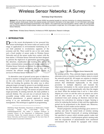
Proceedings of the Fifth IEEE International Caracas Conference on Devices, Circuits and Systems, Dominican Republic, Nov.3-5, 2004Wireless Sensor Networks for Flash-Flood AlertingMauricio Castillo-Effen , Daniel H. Quintela , Ramiro Jordan† , Wayne Westhoff‡ and Wilfrido Moreno Departmentof Electrical EngineeringUniversity of South Florida, Tampa, FL 33620Contact Person: Dr. Wilfrido A. Moreno, E-mail: moreno@eng.usf.edu† Electrical and Computer Engineering DepartmentUniversity of New Mexico, Albuquerque, NM 87131‡ Global Center for Disaster Management and Humanitarian AssistanceUniversity of South Florida, Tampa, FL 33620Abstract— This article presents the ongoing effort in providingthe population of the Andean region of Venezuela with a flashflood alerting system by making use of state-of-the-art wirelesscommunications and information technologies. A key componentof the project is a Wireless Sensor Network (WSN) that is usedfor monitoring the environment and tracking the disaster whileit evolves. Currently, the project is at its conceptual inceptionand system-level design is being carried out. Major design constraints and solutions will be presented with an emphasis on themonitoring system based on the WSN.I. I NTRODUCTIONTechnology has evolved in quantum leaps in recent yearsand still, it is not used for mitigating natural disasters that havedevastating consequences in regions of the world where thelack of preparedness and basic infrastructure are characteristic.This project is aimed at helping the population of theAndean region of Venezuela, specifically, the city of Meridaand its neighboring towns. Large amounts of property loss andcasualties caused by flash-floods have been reported over thelast years. Additionally, hydrological and geological studieshave shown that the region is highly prone to similar eventsin near future.A flash-flood is a sudden discharge of large amounts ofwater. Usually, heavy rainfall increases the level of rivers; atthe same time, a dam-forming effect occurs, triggered by otherphenomena like ice jams or landslides. Flash floods in theregion of Merida have been carefully studied and are now wellunderstood [1]. The mountains that surround the borders ofthe river have geologically unstable characteristics. Under highprecipitation levels, these zones of the mountains give origin tolandslides that fall into the rivers occluding the flow of water.Eventually, these naturally built barriers cannot sustain the highpotential energy of the accumulated water, and finally breakproducing a rush of water that affects the villages downstream.This chain of events happens in a short period of time (fewhours), posing a serious challenge for authorities that try toprotect the population from such disasters.Figure 1 shows a set of houses prone to be wiped out inthe happening of a flash-flood and the interaction between themountains and the rivers in the formation of a flash-flood.Figure 2 shows the consequences of a flash flood in the ”LaVega del La Gonzalez” village affected by the overflow of RioChama in April 2003.0-7803-8777-5/04/ 20.00 2004 IEEEFig. 1. Flash-flood Prone Zone (photo courtesy of the Fire-Fighters Department of Merida [1])The Role of Information and Communication TechnologiesMoney and effort are normally invested to mitigate the effectsof natural disasters after they have occurred. However, in orderto lessen the effects of such events, it is necessary to anticipateits occurrence. The timely access to relevant information onhazardous environmental conditions gives to the communitytime to apply preparedness procedures, alleviating the damageand reducing the number of casualties derived from the event.Advances in networked embedded systems (“embedded nets”[2] enable the acquisition, processing and transmission ofenvironmental data from the location where disasters originateto potentially threatened conurbations. High-end computers canuse this information and serve as sophisticated instruments forauthorities to rapidly assess critical situations and to organizeresources. Meanwhile, signals can be generated to alert thepopulation. Furthermore, based on recorded historical data,scientists can build models to understand and forecast thebehavior of natural phenomena.This article starts identifying general requirements imposedto the design of an autonomous flash-flood alerting system, thenit proposes an overall architecture that fulfills the specifications.The fourth section discusses the suitability of Wireless SensorNetworks (WSN) for flash-flood monitoring. Finally someadditional implementation details are provided that might be142
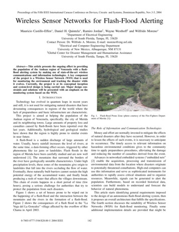
but at the same time, “intelligent” enough not to overreactand trigger false alarms. A fundamental tradeoff for flash floodmonitoring systems is sensitivity vs. false alarms.Regarding user interface related requirements, local authorities and first-response personnel have expressed the desire tobe able to interact with the alerting system from the urban area(cell phones, internet access) or to obtain information from thesensed field through portable equipment such as Personal DataAssistants (PDA). The ability to assign a spatial location tospecific events directly related to the occurrence of flash-floodsis essential, –for example, to observe physical magnitudes ona map of the monitored region.III. OVERALL S YSTEM C ONCEPTFig. 2. Affected village in April 2003 (photo courtesy of the Fire-FightersDepartment of Merida [1])of interest for the use of WSN in similar applications.II. R EQUIREMENTS AND C HALLENGESThe main objective of the system is to gather environmentalinformation and, based on the collected data, to alert theauthorities and the population at risk autonomously. In orderto accomplish this goal, it is necessary to first collect data,to transmit it to a centralized station, and consequently tobroadcast alerts.Compared to environmental monitoring, a flash-flood alertingsystem has more stringent requirements, since the informationdelivered is of vital importance (“soft-real-time”). The systemhas to remain operational at all times even when individualcomponents fail. Thus, the system requires characteristics ofdistributed systems to avoid bottlenecks and to avoid constraining the reliability of the entire system upon individualcomponents.The locations where the data-gathering will take place lackelectrical and communication infrastructure, making conventional monitoring systems that rely on power grids and wiredcommunication links inappropriate. The solution must adaptitself to the environment and rely solely on its own resources,–independent of third-party providers, and working under unattended operation conditions. As a consequence, one designpriority is to maximize the autonomy and reliability of thesystem.Sensors must be easily deployable in order to be strategicallyplaced along the rivers and mountains in locations that areprone to “failures”. An enhancement to the system would beto extend the network by deploying sensors during or after theevent has occurred to obtain a more comprehensive reading ofthe sensed field and to compensate for malfunctioning sensors.This requires an extendable and flexible solution.In addition, the solution needs to withstand sever weatherconditions as it will be exposed outdoors for long periods oftime.It is of fundamental importance to develop a system which issensitive and able to effectively recognize hazardous conditionsAccording to the challenges and requirements identified inthe preceding sections, the system has to fulfill the followingtasks: Gather relevant meteorological and hydrological data fromthe threatened region where the flash-flood and landslidesoriginate. Transmit the data from the “sensed field” to the urban area. Extract and graphically display relevant information toassist authorities to make decisions. Register the collected data and store it for later use. Generate alerting signals. Allow the users to interact with the system via mobileportable devices.As seen in figure 3, the Monitoring Subsystem, located in therural area, performs data acquisition of all relevant variables andincorporates internal communication links that allow the transmission of information from the spatially scattered locations toan interfacing port.The Communication Subsystem manages the transmissionof the collected information from the Monitoring Subsystemto the urban area, assuming the role of an interfacing bridge.Physically, the reception point can be a “Local Office” (forexample, the nearest Civil Defense office or Fire Department)where the data can be collected and analyzed.The data collection and analysis will be handled by a systemwith sufficient computational resources and storage capacity.Based on the processed data, an Alerting Subsystem is responsible for generating alerting messages which can be broadcastedby different means.IV. WSN S FOR F LASH -F LOODSThere are various environmental monitoring systems installed in industrialized countries. Many of them are based ontelemetry systems that make use of remote terminal units tocollect data and in a point-to-point strategy, transmit it to acentral terminal unit. However, such scheme compromises thereliability of the solution as each section or even the entiresensed field might be isolated in the event of terminal unitfailure or malfunction. In addition, each remote unit wouldhave power requirements varying according to the transmissionrange. Alternative solutions based on proprietary technology,143
ngAlertingRural areaUrban areaFig. 3.Block Diagramsuch as Mobitex [4], rely on the communication infrastructureof third-party providers. Such systems diminish the autonomicity proposed for this application, and represent an increase inoperational cost.Based on the imposed requirements of low cost and independency of external service providers for the design of a state-ofthe-art flash flood monitoring system, both solutions mentionedabove fail to qualify. This article proposes the implementationof Wireless Sensor Networks, –“low-power, multihopping systems that combine multiple wireless nodes into an extendablenetwork environment with non-Line-Of-Sight coverage andself-healing datapaths” [5]. WSN nodes, communicate onlywith neighboring nodes to reduce the transmission power, thuseliminating the need for expensive transmitters and repeaters asthose used in traditional telemetry systems. In a WSN, everynode acts as a data acquisition device, a data router, and a dataaggregator. Such architecture maximizes the redundancy andconsequently, the reliability of the entire flash-flood monitoringsystem.The independence from third-party providers and the absence of infrastructure requirements,–as those needed in cellular based telemetry systems, allow a WSN to be deployedquickly. Furthermore, in scenarios where threats may comefrom unexpected locations, having a dynamic and adaptablesolution enables first-responders to act according to criticalsituations. For example, these features facilitate the placementof additional nodes to provide a more comprehensive readingof the event as it happens or just to replace “dead” nodes.In the event of network congestion, node failure, or simplyobstacles blocking line-of-sight communications, the meshedinterconnection of wireless sensor nodes generate alternativepaths for data routing from the source, where the phenomenaoccurred, to the destination, –a network gateway. Networkgateways in a WSN allow the interaction with external systemspossessing more storage and computational capacity to createhistorical databases and for modeling and forecasting purposes.The WSN proposed in this article shares a similar researchagenda with other WSN proposed in the literature [6]. Forflash flood monitoring though, since sensor nodes will remainstationary along the rivers and mountains, the scope of studyemphasizes a sensor network with static nodes, disregardingthe difficulties associated with the implementation of a mobilearchitecture. Some commonalities found in WSN for flash-floods and general WSN are listed below The sensing nodes will work in uninhabited environments.Therefore, nodes have to remain functional for long periods of time without human intervention. The unattendednature of the network requires the solution to be energyefficient in order to prolong the lifetime of the network.Energy optimization at all levels is regarded as the primarygoal in WSN design.The solution needs to be flexible and extendable to accommodate network growth and topology changes. Thenumber of nodes may increase at any time to improve redundancy or just to expand the monitored region. Changesin topology are common in WSN as they are subject toweather and nature-originated inclemencies. The networkrouting protocol needs to include node discovery strategiesand self-forming capability to enable new nodes to join thenetwork.The network discussed can be regarded as a DistributedSystem since sensors have to act cooperatively to providethe collected data to bridge-nodes, to identify internalfailures and to adapt to changes in topology. At the sametime, sensor nodes have to collectively and dynamicallyuse mechanisms that maximize the lifetime of the network,as those proposed in [3].Exploitation of the processing power of the nodes cannotbe overlooked. Localized processing algorithms transmitonly useful data, reducing data rate requirements, networkcongestion and transmission power consumption.Nowadays, there are several technological limitations toWSNs that prevent their wide-spread application. These limitations have to be taken into consideration for the work presentedhere and they are described as follows:144 The expected dramatic reduction of cost of sensor networks [7] has not happened yet. The deployment of largequantities of sensors still represent considerable costs inapplication like those described in this article.The quest continues, for a physical layer that consumes theminimum–possible energy, while conserving enough SNRlevels and immunity against multipath effects. Research onultrawideband-based modulation schemes promises goodresults in near future, as it seems to solve many problems that represent barriers for WSN to become more
widespread.Electronic devices like those used as main processingunits of sensor nodes have power requirements that limitthe unattended operation of sensor networks. Althoughlow-power design strategies at silicon level progressesconstantly, for now use of solar energy and other gridindependent sources have to be deemed.Flash-flood analysisTo adapt the generic concepts of Wireless Sensor Networksto the specific application presented in this paper, the development of a flash-flood in the Andean region has been splittedinto phases described as follows: No Signs of flash flood. The WSN nodes indicate stableparameters throughout the sensed field. Characteristics ofa stable condition include dry weather, normal water leveland flow, high barometric pressure (with respect to otherareas in the country), and static behavior of mountains.Rain formation. Pressure can be an important indicatorin rain formation, as it tends to drop before rainfall. Forinstance, meteorological, hydrological and seismic nodesmay be alerted by the pressure sensors of a possibilityof rainfall to begin a network-wide flash-flood check. Thecheck verifies that the hazardous conditions are met beforetriggering alarms.Rain. Precipitation is of vital importance for a flashflood monitoring system. Landslides and river overfloware products of high level of rainfall for long or sometimesshort, but intense periods.Landslides. They are monitored to prevent dam formingalong the rivers. Rainfall, seismic activity, and unstablesoil are few examples on how landslides may be triggered.These are parameters that need to be kept track of, as wellas the sudden disappearance of nodes.Dam forming. In most cases of flash-floods studied inthe region, landslides are the major cause for dam forming. As the mountain collapses, earth rolls downhill, andeventually reaches the rivers. This is a situation thatshould trigger high-priority alarms to start actions by firstresponders. Under these circumstances, the level of waterraises rapidly in the upstream portions of the river and theflow is reduced drastically.Flash-flood. This situation is very hard to monitor andit is expected that most alerting messages have takenplace before it happens. Nodes being wiped out, extremereadings in some sensors are characteristic of this stage ofthe disaster.Sensor NodesThe WSN will comprise three major types of nodes: Meteorological Node: Located in the surrounding fieldsnext to the river, each meteorological node will monitorlight, temperature, humidity, barometric pressure, winddirection, and wind speed.Landslide Node: Strategically placed in hazardous locations in the neighboring mountains, the node will have ageophone, a soil moisture sensor, and a creep sensor.Alarm generationV. I MPLEMENTATION D ETAILS Hydrological Node: Located in the shore along the river,each hydrological node will monitor the water level andwater flow.To generate alarm messages, the occurrence of a flash floodhas to be identified and/or predicted. The life-cycle of a flashflood presented before, can be associated with different alarmlevels. Higher levels reflect a more critical situation implyingthe imminent strike of a flash-flood.An automated alarming system could use two types ofmechanisms where their results can be compared to avoid falsealarms. A simple inference mechanism, i.e. based on fuzzy logic orintelligent (formerly called “expert”) systems, that basedon actual measurements or changes with respect to previous measurements, tries to identify in which of the sixphases shown above is the flash flood. A more sophisticated mechanism that makes use of modelsto forecast the disaster or critical situations.As an example, a fuzzy inference rule for the inference-typemechanism could read as follows: “Since BarometricPressureis LOW AND SolarRadiation is LOW AND WindVelocityis LOW THEN RainFormationProbability is HIGH”. The execution of such inference engines does not mandate highcomputational resources nor access to the historical register ofdata collected from the field, therefore it could be implementedin a computer with direct access to the sensor network, or evenin a distributed manner within the WSN.The second approach requires models of the flash-floodprocess, and of the hydrological behavior of the region. Inaddition, the system can incorporate optimization strategies thatimprove the models continuously. Running these processes on acomputer (or computer network) requires substantial computingpower, support from a database, and an application that canassociate data with its spatial location.Geographical Information SystemA Geographical Information System (GIS) has all the features needed to implement complex environmental models andmore involved alert message generation since it allows to accessa database that associates information tied to spatial location.The power of using a GIS in conjunction with a WSN lies in theGIS’s ability to transform raw-data,–as the data coming from aWSN, into information. A GIS in the hands of decision makersand authorities becomes a powerful instrument that helps in therapid assessment of critical situations.One additional feature of GIS systems is the ability togenerate HTML code that can be used for broadcasting therelevant information through the internet. For instance, theinformation can be displayed graphically, showing maps withdynamically-changing data. Some cell-phones and PDAs with145
Fig. 4.Flash-Flood Alerting System Exampleinternet access interfaces can then retrieve the information,reaching the population and authorities ubiquitously.Flash-Flood Alerting System ExampleFigure 4 shows an example of a possible flash-flood alertingsystem, similar to a prototype soon-to-be-installed in the regionof Merida-Venezuela. The WSN is responsible for gatheringenvironmental data in the mountains and river near the city.There are two possibilities for gateways to the WSN: A fixed gateway that collects all the WSN information andshuttles it to a central location via a TCP/IP wireless link.A mobile gateway, that becomes part of the network in anad-hoc manner. It can be used for maintenance purposesof the WSN or to collect information in-situ.Some sensor nodes with more power demanding applications, are equipped with solar panels and regulators. This nodesact as cluster-heads aggregating the information coming fromneighboring nodes.Meanwhile, a GIS constitutes the basis for a data-collectionand alarm generation station in the urban area. An internetserver publishes information about the current state of theenvironment. An alarming system runs on top of the GIS,generating alert signals that can be broadcasted to the generalpublic.The solution can be extended to similar applications whichinvolve public safety and civil defense. The system is appropriate for countries that lack infrastructure and resources.It has been shown that the integration of wireless communications and information technologies constitute an asset that canbe used to protect human lives and infrastructure from naturalhazards.VII. B IBLIOGRAPHYR EFERENCES[1] Giovanni Rosales, “Lugares Con Riesgo Potencial,” Internal Report of theFire Department Merida -Venezuela, March 2004.[2] National Research Council, Embedded, Everywhere: A Research Agendafor Networked Systems of Embedded Computers, National Academy Press,October 2001.[3] W. Heinzelman, A. Chandrakasan and H. Balakrishnan,“Energy-EfficientCommunication Protocol for Wireless Microsensor Networks,” Proceedings of the 33rd Hawaii International Conference on System Sciences(HICSS ’00), January 2000.[4] ERICSSON-MOBITEX, Available online, .[5] Warren Webb, “Mesh Technology Boosts Wireless Performance,”, EDNMagazine, November 2003.[6] Deborah Estrin, Lewis Girod, Greg Pottie, Mani Srivastava, “Instrumentingthe world with wireless sensor networks,” Proceedings of the InternationalConference on Acoustics, Speech and Signal Processing (ICASSP 2001),Salt Lake City, Utah, May 2001.[7] Deborah Estrin, Ramesh Govindan, John Heidemann and Satish Kumar,“Next Century Challenges: Scalable Coordination in Sensor Networks,”,Proceedings of the Fifth Annual International Conference on Mobile Computing and Networks (MobiCOM ’99), August 1999, Seattle, Washington.VI. C ONCLUSIONSThe proposed system architecture solves most of the difficulties encountered in the implementation of an automatedflash-flood alerting system. The WSN lends itself well forthis application and practical results are expected to verify theconceptual design.146
Wireless Sensor Networks for Flash-Flood Alerting Mauricio Castillo-Effen , Daniel H. Quintela , Ramiro Jordan†, Wayne Westhoff‡ and Wilfrido Moreno Department of Electrical Engineering University of South Florida, Tampa, FL 33620 Contact P