Transcription
Draft UC Davis Bicycle and Transit Network StudyCAMPUS BIKEWAY SYSTEM – FUTURE CONDITIONSThis section describes the future campus bikeway network once theWest Village and other campus developments envisioned in the 2003Long Range Development Plan (LRDP) and in the soon-to-bereleased Centennial Plan are constructed. The improvements that theBTNS recommends to the campus bikeway network are intended toaccommodate this future use and are described in this section.Future DevelopmentIn 2003, UC Davis released its LRDP, a comprehensive land plan toguide the physical development on campus through the 2015-16academic year. The LRDP identifies the areas of campus to be furtherdeveloped, as well as the types of new uses that should be included ineach location. Specifically, the LRDP identifies the West Village as thefuture location for faculty/staff and student housing as well as limitededucation, commercial and administrative uses. The LRDP alsoidentifies numerous locations throughout the campus where usescould be intensified.The UC Davis Centennial Plan, which is being developed in parallelwith the BTNS, establishes a longer range vision for the CentralCampus development. The Centennial Plan identifies new buildings tobe constructed, as well as the general location of new alignments forroadways, bikeways, transit routes, and pedestrian paths. Among themost significant improvements envisioned by the Centennial Plan: The extension of A Street to Old Davis Road accompanied bynew buildings between this new roadway and the Arboretum A new quad south of the current Biological Sciences Building,which would be surrounded by new buildings Additional development and connections to the MedicalScience district Realignment of the shared bicycle-pedestrian path onCalifornia Avenue south of Hutchinson Drive Construction of bicycle lanes along Orchard Road to facilitatetravel between the West Village and Central CampusThese future improvements will influence the way the campus bikewaynetwork is utilized. The BTNS proposes improvements to the campusbikeway network to accommodate future travel demand.Future Use of Campus BikewaysPrior to recommending specific improvements, the campus bikewaynetwork was evaluated based on existing and anticipated future travelpatterns once the West Village and other planned developments are inplace. Essentially, this evaluation entailed identifying which bikeway24
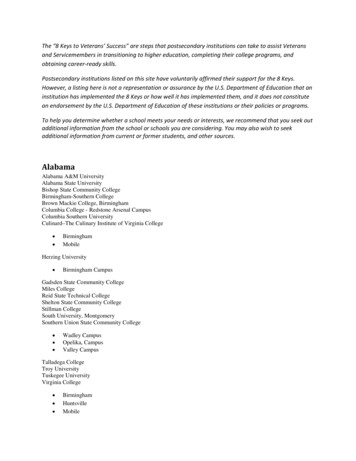
Draft UC Davis Bicycle and Transit Network Studyfacilities are most used today and identifying additional facilities thatwould carry high bicycle volumes in the future.Figure 7 categorizes the campus’ major bikeway routes and gatewaysby anticipated future level of use. The gold lines show the routeswhere the heaviest volumes of cyclists are anticipated, with purplelines representing routes where low to moderate use is expected. Thisanticipated future level of use is given context by specifying whichroutes have established bicycle facilities (solid lines) and which routeshave either limited or no bicycle facilities (dotted lines). 3The figure reveals a few corridors where high demand for cycling isexpected, but limited facilities exist: Hutchinson Drive between Bioletti Way and California Avenue Orchard Park Circle west of Orchard Park Drive California Avenue between Russell Avenue and North QuadThe high demand volumes and corresponding lack of facilities suggestthat these should be high priority locations for capital improvement.Other locations showing bicycle demand, but limited facilities include: The southern portion of Howard Way (between the busterminal and North Quad) Walkway south of the Memorial Union Walkway north of Mrak Hall Visitor Parking Lot 25Consideration should be made as to whether bicycles should beaccommodated or prevented from traveling in these locations (perhapsthrough design modifications).3This map assumes mostly existing facilities, but does assume the planned West Villagebikeway network, since these facilities would likely be provided in the absence of thisPlan.25
!!!!!!!!!!!!!!!!!! !!Kleiber !!!!! ! ! !!! ! ! ! !!!!!!!!!!! ! ! !!!!!!!!!!!!!!!!!!!!! !!!!!!!!!!!!!!! ! !! ! ! !! ! !! ! ! ! ! ! ! !! !!!!!!!!!!!!! ! ! ! ! ! ! ! ! ! !! ! ! !!!!!!!!!!LEGENDAccess Point to Campushh§ 80Heavy UseModerate UseBicycle CorridorHeavy UseHeavy Use with Limited/No Facilities!!!!Planned Facilities for Heavy Use!! !!!!Moderate Use with Limited/No Facilities!!!!!!! !!! !!!!!!Garrod Dr.!! !!!!!! ! !!!!!! !!!!!!!!Moderate Use!West Health Scie!!!!Campbell Rd.nceDr.!!!!! ! ! ! ! ! ! ! ! ! !!! ! ! ! ! ! ! ! ! ! ! ! ! !! ! ! ! ! !Rd.! ! ! ! ! ! ! ! La! !Rue!!!!!!!!!!h!!! !! !!!!!!!!!!Dairy Rd.!!!!!!!!!!!!!!!!!!! !!!!! ! !!! !!!! !!! ! ! ! ! ! ! ! ! ! ! ! ! ! ! ! !! ! ! ! ! ! ! ! ! !!!! ! ! ! ! ! ! ! ! !!!!!h!!!!! ! !!! ! ! ! ! !!! ! ! ! !!!!!!!!!!!!!!!!!.s Av e!!!!!!! ! !! ! !!!!!!! ! ! ! ! ! ! ! !! ! ! ! ! ! ! ! ! ! ! !!!!!!!!!! !!!!!!! !! ! ! ! !! ! ! !!!!!!!!!ldJ ShiePeterA S t.!!!h!!!!!!!!!!!!!!!!!!!!!!! !! !Extension Center Dr.!!!!!!!! ! ! !h!!!!!!Old Hutchinson Dr.!!!!!!!!!!!!!!!!!!!!!!!UC DavisCentral Campus!!!!!!!!!!!!!!!!!113Q ua dQu a d!!!!!!!!!!!!!!!!!!!þ} ·North!!!!! ! ! !! ! !h!!!!!!!!Orchard Park Dr.!!!! !!!!!!!!!!!!!!!!!!!!!!!Orchard Park Cir.hWest!!!!!!!!!!!!!!!!!!!!!!!!! !!! !!!!!!!TheWestVillagePhase II!h!!!!!!!! ! ! ! ! ! ! ! ! ! ! ! ! ! ! !!! ! ! ! ! ! ! ! !!!!!h hhhhyrd WaHo w aTheWestVillagehhve.rnia A!!! !!!!!!!!!!!!!!!!!!!!!!!!!!!!!!!!!!!!!!!!! ! ! ! ! ! ! ! !! !! ! ! ! !! !!!! !!!! !!!Califo!!!!! !! ! !!!!! !!!!!!!!!!!Russell Blvd.Planned Facilities for Moderate UseUC Davis Campus Boundaryh!NNOT TO SCALEUC DAVIS BIKE AND TRANSIT NETWORK STUDY PLANNED BICYCLE FACILITIES STRATIFIED BYANTICIPATED LEVEL OF USEN:\2008Projects\SA Projects\0117 UCD BTNS\GIS\Dec2008\MXD\fig07 bikefac levl use.mxdFIGURE 7
Draft UC Davis Bicycle and Transit Network StudyRecommended Bikeway ImprovementsBased on the anticipated future use of campus bikeways andcommunity input regarding concerns about the existing bikewaysystem and desired improvements, the BTNS recommends a numberof capital improvements to the campus bikeway system.Types of Bikeway FacilitiesThe BTNS identifies four types of bikeway facilities on campus. Eachof these designs addresses the function of the bikeway facility in termsof the specific modes accommodated, the volume of bicycles andpedestrians carried, and the types of trips using the facility. Thesedesigns are not new to the campus; however, as bikeway facilitieshave been constructed gradually over the years, campus bikewaydesigns have never been formalized.The four design standards recommended in this BTNS include: Bikeway streets – as the widest bikeway facilities, they carrybicycles and select motor vehicles, have parallel pedestrianfacilities, and provide room for vehicle parking in some cases.Bikeway streets can accommodate heavy bicycle volumes andrelatively high speeds; they serve the majority of through-biketrips and trips entering/exiting campus, but also internal trips. Separated, bicycle-only paths – paths that provide exclusiveaccess for bicycles and have parallel pedestrian facilities. Theseparation of bicycle and pedestrians allows for relatively highbicycle speeds. These paths tend to carry a major portion oftrips entering/exiting campus and through trips, but also serveshorter internal trips. Bike lane (on-street) – on-street lanes provided on roadwaysserving primarily motorized vehicles. The lanes, which arelocated mostly on the periphery of campus, carry a majorportion of entering/exiting trips. Shared-use paths – these paths serve both bicycles andpedestrians and tend not to include parallel pedestrianfacilities. These pathways provide for shorter, low-speedinternal campus trips.Table 2 provides more detail on each of the bikeway designs. TheBicycle Design Guidelines later in this chapter provide the specificcross-sections and standards for each facility type.27
Draft UC Davis Bicycle and Transit Network StudyTABLE 2: BIKEWAY DESIGNSFacility TypePurposeTrip TypeLevel of BikeUsageProvision ofSeparatePedestrianFacilityAccess ControlBikeway StreetServes majority of through bikeServes both shorttrips, and trips entering campus,and long tripsbut also serves internal tripsVery High toModerateYesLimited crossingsand accessSeparated BikePathCarries major portion of tripsentering and leaving campus.Serves majority of through biketripsGenerally servelonger tripsVery High toModerateYesLimited crossingsand accessCarries major portion of tripsentering and leaving campusServes mediumand longer tripsHigh toModerateYesLimited crossingsand accessProvides for internal campus tripsServes shortertripsLowNoFew restrictionsBike Lane(On-Street)Shared Use Path28
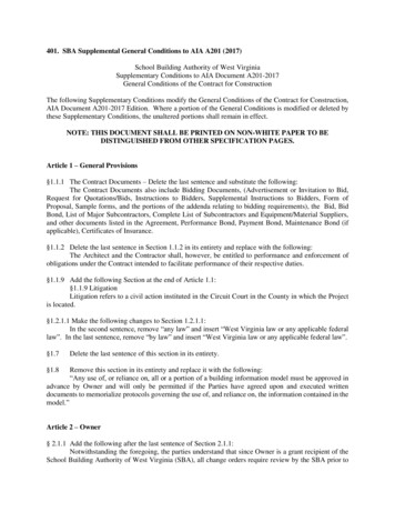
Draft UC Davis Bicycle and Transit Network StudyUltimate System MapThe campus’ existing bikeway network was evaluated to determine itsability to accommodate future demand. Based on anticipated futuredemand, the BTNS recommends that many existing facilities beupgraded in order to accommodate increased volumes resulting fromcampus development and to reduce modal conflicts, which communitymembers have highlighted as a concern. The BTNS also recommendsdesigns for new bikeway facilities, which will be needed to supplementthe existing system to accommodate future demand.Figure 8 shows the ultimate bikeway system recommended by thisBTNS. This figure distinguishes between existing infrastructure (whichwould remain unchanged) and improvements proposed by the BTNS.The most significant recommendations include: Provision of on-street lanes along the extension of A Street toNew Davis Road, creating a new, southerly route for cyclists Striping on-street lanes on California Avenue between RussellBoulevard and the northern gates Constructing a separated path through the MU bus terminal toconnect Howard Way with North Quad Converting western portion of Orchard Park Circle into abikeway road to close gap in bikeway network and enhanceconnections between Central Campus and West Village Constructing shared-use paths connecting the HealthSciences District with the Arboretum and South Campus Extending California Avenue south of Hutchinson Drive as aseparated path, replacing the jumbled network of shared-usepathways that currently exist Providing continuous on-street bicycle lanes on First Streetbetween A Street and D Street and converting existing shareduse path to a pedestrian-only trail Converting the following shared-use paths into separatedpathways to provide for better modal separation and to reducecongestion: East-west route connecting West Village and North Davisto Central Campus East-west route connecting Segundo Dorms and the ARCwith North Quad East-west route connecting the Stadium and TerceroDorms with Central Campus29
Russell Blvd.!! !!!!!r.6CiParkolan! !! !! !!!! !! !!!!!!!! !! !! !! !!! !! !! !!!§ ! !! !! !!!80Planned Separated Path ImprovementsPlanned Shared-Use Path ImprovementsPlanned On-Street Lane Improvements!!!! !! !!!!!!!!!So!!!!!!!!6! !!! !!! !! !! !! !! !!! ! ! ! !!!!! !!!!!!! !!!!!!!!! !!!!! !!!6í!!!! !!!! ! ! !!!!!! !!!!!!!!! ! ! !!!!!! !! !! !!!!!! ! !!!!!!!!!!!! !! !!! ! ! ! ! ! ! ! ! ! ! ! ! ! !! ! ! !!!!!! !!! !!!!!!! !!!!! !!!!! !!!Existing Shared Street!!!!!!!!Bikeway Street pBusTerminalBus-Bike Boulevard6íGrade Separated Bike/Pedestrian Crossing!!!!!!! ! !!!!!!!! ! ! !!!!! !!!!!!!!!! !!!!!!!! !!! ! !! ! ! !!! !! !!!!!! !!!!!!!!!!!!!!! !!!6!!!!!! !!! !! !!! !! !!!!!!Kleiber HallDr.!!!!!!!!!!! !! ! ! !!!! !!!!!!!!!! ! ! !!! !!!!!!! !! !!! ! ! ! ! ! ! ! ! ! ! ! ! !! ! ! !!!!! !!! !! !! ! !! ! !!! !!!Dairy Rd.!!!!!!!!! !!!!!!!!!!!!!!!!!! !!! !!!!!!!!!!! !!!! ! ! ! !!!!!!!! ! ! ! !!!! !!!!!!!!!!!! !!!!!!! !! !! !!! !! !!! !! !! !! !!! !!! !! !! !!! !! ! !!! !!!! !!! !!! !! !!! !!! !! !! !!! !!!!!! !!!!!Existing On-Street Lane!!!!!!!!!!!!!!!!!!!!!!!!!!!!!!!!!! !! ! ! ! ! ! ! ! !!!!!!! !!!!!6!!!! !!!Existing Shared-Use Path6! !! !! !! !!!!!!!!! !!! !! !! !! !! !!!! !!! !! !! !! !! !! !!!!!! !!! !!!!!! !!!!!! !!!!! !!!!! !!!!!!!!! !!!! !! !! !! !! !! !! !! !! !! !!6!!!!!! ! ! ! ! !!!! !!! !!!!!!!!!! !!! ! ! ! ! ! !! !! !! !!! !! !! !! !! !! !! !! !! !! !! !! !! !! !! !! !! !! !! !! !! !! !! !! !! !! !!! !! !!6!!!! !!!!!!!!!!!! !!!!!!!!!!!!!!!! !!!!! !!!!!! !! !! !!!! !! !!!!!!! ! ! ! ! ! ! !!!6í! ! ! ! ! ! ! ! ! ! !!!!!!!!!! !!!!!!!!! !!!!!!!!!!! !!! ! !! !! !! !! !! !! !! !! !!!!!!!!!!Dr.!!!!! !!! !! !!!!!!!!!Existing Separated Path!!West Health Science!!!!!!!! !!! !! !!!!!!!! !!!!! ! !! ! !!!!!! !!!! !!!!!!!!!! ! ! ! ! ! ! !! !! !!!! !! !!!!!!!!!!!!!!!! !!!!!! !! !! !! !! !! !! !! !!!Bike Facilities!!Campbell Rd.! ! ! ! ! ! ! !! ! !!! !! !! !! !! !! !!!! !! !!! !!!!!LEGEND!! !!!!!!!!!!!6í!!6!! !A St .! !!!!! !!!! !!!!!!!!!!! !!!!!!!! !!!!!!!!!!!!!!!!!!!!!!! !!!!!!!!!!!!!!!! !!!!! ! !!!!!!!!!!! !! !! !!!!!!!!!!!!!!!! !!!!!!!!!!! !! ! ! ! !!!!!!!!!!!!!!!!!!!! ! ! !! !! !! !!!! !! !!!!!!! !!!! !!!!!! !!!!!!!!!! !!!! !!!!! !!!!!! !! !!!! !!!!!!!!!!! !!! ! ! !! !!!!!! !!!!!!!!! !! ! ! !ve.lds AJ ShiePeter! !! !! !!!!! !! !! !! !! !! !! !! !! !! !! !! !! !! !!!!! ! pLa Rue Rd.!!!!!!! !!!! !!!!!!!!!!!! ! !!!!!!!Qu a d! !!!! !!! !! !! !!!! !! !! !! !! !! !! !! !! !! !! !! !! !! !!6í!!Garrod Dr.!!!!!!! ! !!! !! !!!! !! !! !! !!!! !!!!!!!! ! !! !!!!!!!!!! ! ! ! !!!!!!!!!!!!!!!! !!!!! !!!!!!!! !!!!!!! !!!!!6í!!!Q ua dNorth!! !! !! !! !! !!!!!!!!!!!!!!!!!West!! !! !! !! ! ! ! !! ! ! ! !!!!!!!!! ! !!! !!!!UC DavisCentral Campus! !! !! !! !! !!! !! !! !! !!!!!!!!!!!! !!! p! !!!!! !! !! ! !! !! !! !! !! !! !! !! !!!!!!!!!! !! !!!! !! !!!!! !! !! !! !!!!!!!! !!!! !!!!!!!! !! !! !y! !!!rd WaHo w a ! ! ! ! !ve.rnia A!!!! !! !!! !! !!!! !! !! !!!!!! !!!! !!!!!!! ! ! ! ! ! ! ! ! ! ! ! ! ! !!!! !! !! !! !! ! ! ! ! ! ! ! ! ! ! ! ! ! ! ! ! ! ! ! ! ! !!!!!! ! ! !! !! !! !! !! !!! ! !! !!!! !!!! !!Extension Center Dr.!!!Califo!!!!!! !!!! !!! !!! !! !!! ! !!!!!!!! !!! ! !! !! !!! !! !!!! !!!! !!!! !!!! ! !!!!!! !!!!!!!!!!113!!!! !! !!! !! !!! !Old Hutchinson Dr.þ} ·!! !! !! !!! !!! !! !!! !! !! !! !! !!! !!Orchard Park Dr.! !! !!! !!! !! !! !! !! !! !! !! !! !!! !! !! !! !!!! !!!!!!!!! !!!!!! !! !! !!!!6í!!!!!!!! ! ! ! ! !! !! !!!!!!!! !!!!!!!!Orchard Park Cir.6í! !!! !! !! !! !! !! !! !! !! !! !!! !! !!!!!!!!!!!!!TheWestVillage!!! !!!!!! !!!!!!!! !!!! !!!!!!! !! !!!! !! !! !! !! !! !! !! !! !! !!! !! !! !!!!!!!!!!!!! ! !! ! !! ! !! ! !! ! !! ! !! ! !! ! !! ! !! ! !! ! !! !! ! !! ! !!! !! ! !! !!!!!!!!!!!!!!!!!! !! !! !! !! !!! !!!! !!! !!!! !!!!!!!! !!!!!!!! !! !! !!! !!!! ! ! ! ! ! ! ! ! ! ! ! ! !! ! ! ! ! ! ! ! ! ! ! ! ! ! ! ! !! ! ! ! ! ! ! ! ! ! ! ! !! ! ! ! ! ! ! !! ! ! ! ! !! ! ! ! ! ! !! ! ! ! ! ! ! ! ! ! !!!!!!!!!!!!!!!!!!!!!!!!!!UC Davis Campus BoundaryNNOT TO SCALE!!!!UC DAVIS BIKE AND TRANSIT NETWORK STUDY BIKEWAY SYSTEM MAP (FUTURE CONDITIONS)N:\2008Projects\SA Projects\0117 UCD BTNS\GIS\Dec2008\MXD\fig08 future bike fac.mxdFIGURE 8
Draft UC Davis Bicycle and Transit Network Study East-west route connecting campus eastern edge withSouth Davis North-south route connecting ARC and Segundo Dormswith the Diary Road North-south route connecting Housing Services andRegan Dorms with the Biological Sciences andEngineering DistrictsIntersection EnhancementsIn addition to analyzing linear bikeway faciities, this study evaluatedintersections. This study looked at a variety of intersection treatments,including stop-control, yield control, roundabouts, raised crosswalks,HAWK signals, and full signalization. All of these treatments can offerunique advantages and disadvantages: Stop-control: Inexpensive, low profile, and familiar to users ofthe system. However, can be cumbersome to cyclists, asstopping loses momentum and can be a waste of energywhere a complete stop is unnecessary. Stop signs can also beineffective, as they are often violated in locations where usersdo not feel they are necessary. Yield-control: Inexpensive, low profile, and allows users toproceed through the intersection if stopping is not needed. Forthis reason, cyclists tend to prefer yield-control to stop-control.However, yield signs are not widely used and would beunfamiliar to some users. Roundabouts: Allows users to proceed through theintersection without stopping, while serving to slow traffic. Forthis reason, many cyclists enjoy roundabouts. Roundaboutshave the added advantage that they are commonplace oncampus, providing a higher degree of user familiarity. Raised Crosswalks: Provides pedestrians with greatervisibility, and slows conflicting vehicle traffic. However, can becumbersome to cyclists if not designed specifically toaccommodate cycling. Pedestrian/Bicycle “HAWK” Signal: Provides pedestriansand cyclists with controlled crossing either at mid-blocklocations or at intersections with side-street stop controls. Full Signalization: Provides pedestrians with greater visibilitycan provide detectors for cyclists and transit priority. However,full signalization of an intersection is expensive and changesthe aesthetic character of an intersection.The above intersection treatments should be considered and appliedwhere deemed appropriate. Additional study may be necessary toidentify locations that would benefit from various treatments.31
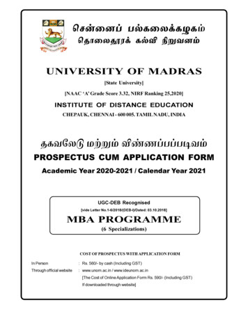
Draft UC Davis Bicycle and Transit Network StudyThis study evaluated several of the key intersections on campus andrecommends treatments to improve flow through the intersection andreduce conflicts. Many of the recommended intersectionenhancements are roundabout treatments, which was a favored optionin the community workshops.New Roundabouts at Intersection of Bicycle Paths: Path along California Avenue Southern Extension/East-westpath south of Bainer Hall Path intersection north of ARC and Lot 25 Path intersection between ARC and Lot 25 Path intersection on south side of Russell Boulevard atSycamore Boulevard Path intersection east of Lot 25 (replacement)New Roundabouts at Intersection of Roundabouts and Bike Facilities: Hutchinson Drive/Bioletti Way Hutchison Drive/Path along Biological Sciences California Avenue/Hutchinson Drive (replacement)New All-Way Stop: Bioletti Way/ East-west path south of Bainer HallFigure 9 illustrates the location of each of these recommendedintersection treatments.Campus-City GatewaysThe following is a description of planned and/or suggestedimprovements to the three primary gateway corridors. Russell Boulevard Corridor – State Route 113 to A Street Third Street Corridor – A Street to B Street First Street Corridor – A Street to B StreetRussell Boulevard CorridorCommunity and campus members requested a number ofimprovements at intersections along the portion of Russell Boulevardbetween State Route 113 and A Street that form the northerngateways between campus and the City of Davis. These intersectionsare managed and maintained by the City of Davis. Improvementsinclude enhancements for bicyclists, pedestrians, and transit users.32
!!!!!!!!!!!! "!!!!!ir.rkCPaolan!!!!!!!!!!!!!!!!!!!!!!!!!!!! ! ! !!! ! ! ! !!!!!!!!!!! ! ! !!!!!!! !!!!!!!!!!! !!! !!Existing Roundabout (Bike-Bike)! Traffic Signal, Planned!H!( "!Planned Roundabout (Bike-Bike)Existing Roundabout (Vehicle-Bike)Existing All-Way Stop! !!!!!!!!!( "!!(!!!Planned All-Way StopBicycle Corridor!! !!Planned Roundabout (Vehicle-Bike)!!Heavy UseHeavy Use with Limited/No Facilities!!!!Planned Facilities for Heavy UseModerate UseModerate Use with Limited/No Facilities!!!!Planned Facilities for Moderate UseUC Davis Campus Boundary!!!!Garrod Dr.!!!!! !! ! ! !! ! !! ! ! !!! ! ! ! ! !! !!!!!!!!!!!!!! ! ! ! ! ! ! ! ! ! !! ! ! !!!!§ !!! !!!! !!!H!( "!80! ! !!!!!! !!!!!!!!Existing Traffic Signal!West Health ScienceD!!!!! ! ! ! ! ! ! ! ! ! !!! ! ! ! ! ! ! ! ! ! ! ! ! !! ! ! ! ! !Campbell Rd.r.!!!!!!!!! "!Rd.! ! ! ! ! ! ! ! La! !Rue!!!!!!!!!!! !So!!!!!!H!Dairy Rd.!!H! ! !! ! !!!!!!!H!!!! ! !! "!Intersection Treatments!!!!!!! LEGEND! !! !!!!!Kleiber HallDr.!(!(!(!!!! ! !! ! !!!!!(!!!!! ! ! ! ! ! ! ! ! ! ! ! ! ! ! ! !!! ! ! ! ! ! ! ! !!!! ! ! ! ! ! ! ! ! !.s Av e "!!!!! !!(! !!! ! !!ldJ Shie!!!!! ! ! ! !!! ! ! ! ! !!!Peter!!!!! ! !! ! !!!!!!!!!!!!!!!!!!!!!!!!!!!!!!!!! ! ! ! ! ! ! ! !! ! ! ! ! ! ! ! ! ! ! !!!!!!!!!!!!!!!!!!!!!!!!!!!!!!!!!!!!!!!!!!! !! ! ! ! !! ! ! !!!!! !!!!!!!!!!!!!!!HA S t.!!!! "!!(!!!!Extension Center Dr.!!!!!!!! ! ! !!(! ! ! !! !!!!!!!!!!!!!!!!!!!!!!(Q ua d!!!!!!Old Hutchinson Dr.!!!!!!!!!!!!!!!!!!!!!!!! North!!!!!!!!!!!!!!!!!113!H!(!HUC DavisCentral Campus!H!!!!!!!!!!!!!!!!!!!!!!þ} · "!Qu a d! ! ! !! ! ! "!!H!!!!!!!!!Orchard Park Dr.!!!! !!!!!!!!!!!!!!!!!!!!!!!!!!!!H!!!! !!! West!TheWestVillagePhase IIOrchard Park Cir. "!!!!!!! !!!!!!!!!!!!!!!!! ! ! ! ! ! ! ! ! ! ! ! ! ! ! !!! ! ! ! ! ! ! ! ! !!!!! !!!!!!!!TheWestVillage!H!Hyrd WaHo w a!!! !!Hv e.rnia A!!!!!!!!!!!!!!!!!!!!!!!!!!!!!!!!!!!!!!!!!! ! ! ! ! ! ! ! !! !! ! ! ! !! !!!! !!!! !!!Califo!!!!! !! !!!!! ! ! ! ! !!!!!!!!Russell Blvd.!NNOT TO SCALEUC DAVIS BIKE AND TRANSIT NETWORK STUDY EXISTING AND PLANNED INTERSECTION TREATMENTSN:\2008Projects\SA Projects\0117 UCD BTNS\GIS\Dec2008\MXD\fig09 intersect treat.mxdFIGURE 9
Draft UC Davis Bicycle and Transit Network StudyThis would include modifications to the traffic signals, signing, andstriping at each intersection.It is suggested that UC Davis, the City of Davis, Unitrans, and Yolobusjointly pursue grant funding to comprehensively address theseimprovements. The grant would provide “Multi-Modal Enhancementsfor the Russell Boulevard Corridor and the UC Davis-City of DavisGateways.” The purpose of the improvements would be to provideimproved bicycle and pedestrian crossing treatments as well as transitsignal priority and preemption along the corridor.Third Street CorridorThe City of Davis is currently developing a corridor plan for thesegment of Third Street between A Street and B Street. UC Davis willwork with the City of Davis to plan appropriate gateway modificationsat the intersection of A Street/Third Street that are consistent with thecorridor improvement plan.First Street CorridorThe Downtown-Campus Connections Concepts and ImplementationPlan (March 2006) was a collaborative effort by UC Davis and the Cityof Davis to improve the physical connections between the MondaviCenter District, the Core Campus Arts District, and downtown Davis.The Plan includes the following improvements to the First Streetcorridor and the First & A Street Gateway. Provide bicycle lanes on First Street between B Street and DStreet and designate the southern sidewalk as a pedestrianzone, where bicycles are strongly discouraged by design. Thisconcept requires bicyclists heading westward from theRichards Boulevard undercrossing to cross First Street at DStreet to get to the westbound on-street bicycle lane west of DStreet. The First Street and A Street intersection will be reconfiguredto provide one-way movements around a central square. Thedesign facilitates access from all connecting streets, andavoids the need for a signalized intersection.BICYCLE PARKINGExisting Bicycle ParkingThe UC Davis campus provides approximately 20,000 bicycle parkingspaces at racks. Bicycle parking spaces are provided at or near everymajor building on campus.Existing Bicycle RacksThe campus has four different types of parking racks. The newer,preferred types of bicycle racks are the “lighting bolt” and the “coathanger” types. The campus has been replacing the older “concrete34
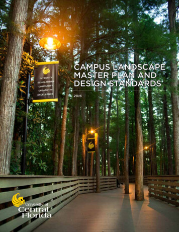
Draft UC Davis Bicycle and Transit Network Studypod” and “black loop park-rite” type racks, as funds are available, overthe past decade.In addition to racks, the campus includes 76 bicycle rental lockers and12 “BikeLid” lockers available on a first-come, first-served basis. Thesefacilities, which constitute a minor component of the campus bicycleparking infrastructure, offer advantages of additional theft-resistance,durability, and weather protection.Existing Valet Bicycle ParkingTAPS provides free, attended bicycle parking at Aggie home footballgames. The valet bicycle parking supplements the existing bike rackslocated at Aggie Stadium.Proposed Bicycle ParkingThe campus goal is to install an additional 2,500 bicycle parkingspaces and replace approximately 5,000 of the older bicycle racks.Figure 10 shows the location of the 2,500 new bicycle parking spacesas well as the high-priority locations for replacement of approximately1,500 older bicycle racks.Standard Bicycle RacksThe standard campus bicycle rack for all future installations is the“lighting bolt” type rack. These racks can be installed individually or ina rack form.Older racks such as the concrete pod or the black loop park-rite typeracks should be replaced and new installations should use the lightingbolt type rack.The Bicycle Design Guidelines later in this c describe the bicycleparking standards.Future Valet Bicycle ParkingValet bicycle parking should be used to create additional capacity inspecial event areas. Valet parking can create the needed capacity forfuture special events at Aggie Stadium and other locations on campus.35
Russell Blvd.v e.rnia Ayrd WaHo w aCalifoOrchard Park Cir.3ST2TS17ST18TSOld Hutchinson Dr.10TS9ST2STExtension Center Dr.12ST13TS14ST4TS6TS7STlanSoDr.nce15STWest Health ScieCampbell Rd.11SToDairy Rd.20TS.s Av e35TSST12TS19TSldJ ShieC ir.9TSPeterParkKleiber HallDr.1T8STS7TS11TSA St .8TS5ST6TSQu a d4TSUC DavisCentral CampusOrchard Park Dr.1131STQuadWestþ} ·NorthLa Rue Rd.16ST§ 8010STLEGEND1ST1TSNew Bike ParkingReplacement Bike ParkingUC Davis Campus BoundaryGarrod Dr.21STNNOT TO SCALEUC DAVIS BIKE AND TRANSIT NETWORK STUDY RECOMMENDED IMPROVEMENTS TO BICYCLE PARKING ON CAMPUSN:\2008Projects\SA Projects\0117 UCD BTNS\GIS\Dec2008\MXD\fig10 bike parking.mxdFIGURE 10
Draft UC Davis Bicycle and Transit Network StudyBICYCLE DESIGN GUIDELINESThe design guidelines will assist campus planners and designers inaddressing bicycle facilities. These guidelines recognize and seek toprotect the unique context of the campus.The design guidelines address the physical treatments recommendedfor bikeways on the UC Davis campus, including bike facility design byfacility type, intersection treatments, roadway crossing treatments,bollards, signage and markings, lighting, bicycle parking, andinnovative treatments.The following sources were referenced in the preparation of theguidelines. UC Davis Long Range Development Plan, 2003 West Village EIR, Neighborhood Master Plan, Site Plan,Implementation Plan, and Faculty Staff Housing Policy, 20032006 UC Davis Bicycle Plan, 2002 Draft Alternative Transportation and Parking InvestmentStudy, 2007 California Building Code, Title 24, Part 2, 2001 California Department of Transportation, Bikeway Planningand Design, July 1990 California Department of Transportation, Highway DesignManual, Chapter 1000 California Manual on Uniform Traffic Control Devices, Part 9 –Traffic Control for Bicycle Facilities, April 2006 Guide for the Development of Bicycle Facilities, AASHTO,1999 UC Berkeley Campus Bicycle Plan, 2006Campus Bikeway Design by Facility TypeFigure 11 shows typical cross-sections for the four bikeway facilitytypes that comprise the planned future bikeway network. Figure 8shows the location of different bikeway facilities. A description of keydesign features for each bikeway facility type is provided below.37
Path - scapeArea/Fencing*0’-6’Bike PathLandscapeArea/Fencing*4’-8’Sidewalk* In locations whereright-of-way is availableShared Use Path10’-20’Landscape AreaBike/Pedestrian Shared PathLandscape AreaBike Lane (On-Street)5’-8’SidewalkBike Lane5’-8’Vehicle LaneCLVehicle LaneBike LaneSidewalkParking insome casesSidewalkBikeway RoadSidewalkParking insome casesBike/VehicleShared LaneCLBike/VehicleShared Lane20’-30’TYPICAL SECTIONSN:\2008Projects\SA Projects\0117 UCD BTNS\Graphics\Dec2008\AI\XSections.aiFIGURE 11
Draft UC Davis Bicycle and Transit Network StudyBike Path – SeparatedSeparated bike paths are bikeway facilities on exclusive right-of-waythat have a central section reserved for bicycle use only. This centralportion should be 16-20 feet wide, with a minimum width of 10 feet.Sidewalks located at the edge of the bicycle path, separated from thebike path by a landscaped area or fencing where sufficient space isavailable, are provided for use by pedestrians. The sidewalks shouldbe 6-8 feet wide, with a minimum width of four feet.Separated paths are designed to serve high volumes and/or longerdistance bicycle travel. Shared use paths are planned for routes thathave a combination of moderate to high bicycle volumes (e.g., oneway bicycle volumes ranging from 300 to 600 vehicles per hour) andmoderate pedestrian volumes (e.g., pedestrian volumes greater than100 per hour). These paths are shown on Figure 8.Although the campus has several existing separated bike paths,pedestrians frequently walk on the central bike lane and avoid thesidewalks. This results in conflicts between cyclists and pedestrians,and limits the effective capacity of these paths. A key element of thisplan is to implement new separated bike paths, improved sidewalks,enhanced signage and pavements markings, and enforcementprograms that will force pedestrians to use the parallel sidewalks.Shared Use PathShared use paths are facilities on exclusive right-of-way that are usedby both cyclists and pedestrians. The shared use paths are plannedfor areas where lower bicycle and pedestrian volumes occur, and/orunobstructed space is severely restricted. The path should be 16-20feet wide, with a minimum width of 10 feet.Bike Lane (On Street)Bike lanes are used to separate cyclists from motor vehicles on highervolume and higher speed roadways. They are planned for roadwaysthat carry 2,000 or more vehicles per day per lane or have postedspeeds of 35 mph or more. This includes portions of Hutchison Drive,LaRue Road, New
East-west route connecting Segundo Dorms and the ARC with North Quad . 8\MXD\fig08_future_bike_fac.mxd UC DAVIS BIKE AND TRANSIT NETWOR