Transcription
BIBLEGEOGRAPHY1Ernest A. Clevenger, Jr.
TEACHER’S HANDBOOKBIBLEGEOGRAPHYFirst Edition published by Parchment Press as one of the Bible Centered Studiesseries, written by Ernest A. Clevenger, Jr. and Samuel G. Hill, and Copyright, 1968,by Parchment Press. This edition revised, 2011, by Ernest A. Clevenger, Jr. Copyright, 2011 by Ernest A. Clevenger, Jr.Published by Clevenger Publications1136 Lipscomb DriveNashville, TN 37204Email: clevengerea@comcast.netPermission is hereby given to freely reproduce, use, and/or print this bookwithout additions or deletions or changes of any kind.2
FOREWORDThe eleven books in the Bible Centered Studies Series were originally writtenover a period of fourteen years, from 1960 to 1974: a time when rote was anacceptable, enjoyable and profitable method of teaching and learning. Each of theeditions consisted of a Teacher's Handbook and the associated Student Guidecontaining a special instructional method utilizing rote. Each book had from 60 to 100Key words or terms related to the Bible subject. The teaching method used in theseries is not solely rote, although that word helps to describe the methodology.The eleven books in the Bible Centered Studies Series are:The Bible, 1960: an history of the English Bible and annotated outline ofits contents.The History of God People, 1963Bible Geography, 1965Jesus of the Bible, 1965Wisdom Books of the Bible, 1966Bible Doctrine, 1967Bible Evidences, 1968Bible Survey, 1969Bible Characters, 1970History of the Bible Church, 1971The Godhead and the Bible, 1974Originally produced for Central Alabama Christian Youth Camp (CACY Camp),Birmingham, AL, the series became popular worldwide for use in Christian YouthCamps, in Vacation Bible Schools, Sunday Schools, and in other types of Bible classwork. Although emphasis is upon camp use, the adaptability for use in other areas wasalways readily evident. This series came about as the result of using a novel teachingmethod which was proven enjoyable, profitable and challenging, especially to youngpeople ages seven through seventeen and particularly in a Christian Youth Campenvironment.By trial and error, over a period of eight years, Bible Centered Studies methodwas refined to an art. This method is no experiment. We discovered campers studyingby flashlight under their blankets after lights out, standing in meal line studying, usingfree time and other time to get one more chance to go over their Bible class drill work,causing us to become a devotee of the Bible Centered Studies method.THE HANDBOOKThe handbook contains all the material essential to presenting meaningfullessons that are vital to Christian young people. With the Bible as a textbook, thishandbook, through the teacher, will direct students in a study of great importance inleading one to Christ or giving a .better understanding of how a Christian should live.The success a teacher has will not depend upon this handbook; rather it will dependupon the textbook, the Bible, and upon the teacher‟s preparation to present the lessonsin an effective manner.3
THE STUDENT GUIDEWith the Bible Centered Studies method it is not necessary for students to havean elaborate workbook or a copy of the handbook. They will need their Bibles. Theywill not need to write anything, nor make any advanced preparation for each newlesson; another reason why the method is ideal for camp, Vacation Bible School, andSunday School use. The student‟s guide contains only the key terms, definitions andoutlines, all in consecutive order. The study is designed for the class to cover thematerial as fast or as slowly as the teacher wishes. A free PDF of the Student Guide,as well as the Teacher Handbook PDF, may be found and downloaded athttp://www.clevengers.info/Clevenger Ernest Jr/ernest allen clevenger.htm.THE METHODThe experienced teacher may use whatever methods he/she wishes. Themethod recommended for use with Bible Centered Studies is based upon the inherentadvantages of drill work. The method is not solely rote: the method is the introductionof Bible facts by the teacher to the student with sufficient association and relatedmaterial to enable the student to retain and use these facts by learning certain keyterms. These key terms, in turn, trigger the memory to produce a definition whichfurther causes recall of the desired lesson or lessons. The outlines in the lesson areabout Biblical groups of geographic or historical places or events used in relation tosome of the key terms.This method permits students to have ready for use vast amounts of material, butinitially responsible for relatively few key terms and definitions. The teacher, using theBible and handbook, introduces a key term and discusses it. Then, he/she introducesits‟ definition and discusses it. One or more students might be called upon to explaineach term in their own words to ascertain if the teacher got the message across. Thena second key term is introduced, discussed, etc. Emphasis is placed upon the keyterms, the definitions and the outlines and the meaning of each.The teacher should be able to ask a student, anytime following the presentation,any key term by giving the definition, or the definition by giving the key term. As anexample: should a key term be “Mount Moriah,‟‟ the student would respond with thedefinition “Abraham offered Isaac”, or, vice-versa. If called upon further, the studentshould be able to explain how God commanded Abraham to offer Isaac as a sacrifice,how they journeyed to Mount Moriah, today the city of Jerusalem, prepared thesacrificial altar, laid Isaac on it, and an angel of the Lord stopped Abraham who thenfound a ram which was offered. Abraham‟s obedience was a test of his faithfulness.All of this information about the Bible story would be based upon the presentationpreviously made by the teacher.Some of the material needing to be studied cannot be reduced to a key term andbrief definition. In such cases, an outline is used. As a rule, the teacher will spend lesstime presenting outlines than key terms because the outlines are more self-explanatory.These outlines are brief and arranged for rapid retention. Frequently, outlines areassociated in part with one or more key terms and definitions.After presentation of the key terms and outlines, to indelibly impress them uponthe student‟s mind, a drill period is held. It may be conducted in one or more of thefollowing ways, or by a combination of them.4
(1) The teacher calls out the key term and the class responds in unisonwith the definition.(2) The teacher gives a key term and calls on a student to give thedefinition.(3) Divide the class into small groups. Students take turns calling out thekey terms, others in the group either individually or in unison reply with thedefinition.(4) Number the class consecutively. Pair off students by one odd and oneeven number. Have students drill one another by one giving the key termand the other replying with the definition.(5) Conduct the drill session like a spelling bee; those who miss areeliminated and sit down.(6) Conduct the drill session by having students stand in a straight line.Those who answer correctly move to the head of the line, those who missto the foot. Object: Try to stay near the head of the line.(7) Have students stand in a straight line. Set a time limit (5 seconds).Students who miss must go to foot of line. Object: To try to work yourselfto the head of the line by not missing.Many of these suggestions may be used by first giving the key term andexpecting the definition, then reversing the process by giving the definition andexpecting the key term. Once students learn the method it never ceases to be alearning situation which is fun.CLASS PROCEDUREBible Centered Studies series themes are adoptable for many types of campand Bible class situations. Following are two suggestions as to a Bible Campprocedure: one for a week‟s camp, the other for a two week camp. Variations such astwo class periods per day can be easily managed. Themes from the series have beensuccessfully used in adult classes, Ladies Bible classes, and Teen and College classesover periods as long as one year by the teacher expanding the handbook material withvisual aids and information obtained from other sources.For the most effective camp use, campers should be divided into classes of from15 to 20 students each, no more than 25. These classes should be formed by age orpier groups. The methodology works best when students of the same age studytogether.5
For A One Week Camp or VBSSuggested class schedule for a one hour class.Check roll and open class with a prayer5 minutesPresent new material25 minutesDay One: Drill on new material30 minutesDay Two and following: Review Drill of old material 15 minutesDay Two and following: Drill on new material15 minutesAfter the introduction of the subject at the first class period, begin presenting keyterms and definitions. Early in the week more time will need to be spent presentingmaterial than in drill; toward the end of the week more time should be spent in drill thanin presenting new material. Thus teachers should plan their lessons to cover a greatnumber of key terms in early classes. Percentage wise, for a one week, one lesson aday class, the presentation of key terms and outlines would be as follows: 1st day, 30%;2nd 25%; 3rd 20%; 4th 15% and 5th 10%.For a one week, two daily class periods camp, the percentage of key terms andoutlines to be used would be as follows: 1st class, 20%; 2nd class, 15%; 3rd through8th classes, 10% each; and 9th class, 5%. The 10th class would be used for testing.The more classes, and the longer the class, the more time for both presentation anddrilling.For a Two Week Camp or VBSThe same basic schedule as for a one week camp is used. Should one class perday be held, Monday through Friday, the same percentage of key terms and outlines tobe presented daily as for a one week camp, two daily classes would hold true. For atwo class per day, two week camp the following percentages should be observed. 1stclass, 10%; 2nd through 19th classes, 5%; and the 20th class used for testing. At longercamps, and for some themes, some class time may be devoted to projects and visualaids which are related to the Bible study theme.INCENTIVES FOR LEARNING“There is no royal road to learning.” Some things, such as the multiplicationtables, have to be learned by rote. In the Bible Centered Studies series, memory workis of prime importance. Some things have to be learned by drilling over and over; whichreally is an excellent manner of retention and learning. To aid in learning the material tobe covered, the author has made every conscious effort to relate important names,places and events both in a logical sequence and by a direct appeal to the Word ofGod.In addition to these efforts, two other suggestions are offered as incentives forlearning. These may be used either on a camp wide or total VBS basis or for individualclasses.To encourage learning, it may be desirable, challenging and fun, to have whatmight be called a “contest”, or an “elimination” to determine which students haveretained the greatest amount of material. The elimination is based upon ability to retain6
key terms, definitions and outlines, and not upon the knowledge about these. Theknowledge must be imparted, if possible, during the course by the teacher and thememorizing of these terms is to serve as an aid in retaining the knowledge.One successful method of eliminating all but the students who have learned wellthese terms is similar to a spelling bee and is as follows: The students are placed in astraight line, the teacher designates one end of the line as the “head” and the other endof the line is designated the “foot.” Beginning with the head of the line, the first studentis given a key term, such as “Eden”. The student should answer “Adam and Eve”.Should the student answer correctly, he/she remains at the head of the line and the nextkey term is given to the next student. Should he/she miss, or be unable to give thecorrect answer, he/she goes to the foot of the line. The one remaining at the head ofthe line at the end of the time designated (20-30 minutes) is the winner.Have A Double EliminationTo have a double elimination, that is to allow more than one chance to answercorrectly, the procedure is as follows: Assemble the students as for a spelling bee.When a student fails to answer correctly, let them form a second line. See the drawing.When a student in line one, A, misses or fails to answer he/she moves to the foot of linetwo. Then, B, the first student in line two is given an opportunity to answer correctly; ifhe/she cannot he/she goes to the foot of his line, C. Should he/she answer correctly,he/she goes to the foot of line one, D, to begin his second chance for one of the topplaces or the top place in his class.Each person in line two should be given the opportunity to answer correctly untilsomeone does, or it is evident that none in the line know the answer. The questioningthen returns to the head of line one and continues the process. In some contests anystudent who misses twice is eliminated then. Some camps have gold ribbons printed tooffer as rewards to winners of the elimination contest. Others give nice Bibles towinners. It is possible for more than one student to have memorized all the correctanswers, backward and forward. This is the purpose of the class drill and of the contestto encourage just that. In such cases, more than one “winner” will have to beannounced for the class. Often, in a group, after the individual classes have conductedeliminations, the entire school or camp will have a contest to determine the groupwinners. All students should remain with their class, or group, as hearing repeatedly theterms and definitions and recitation of the outlines will only enhance their retention.One camp awards 1st place gold ribbons to all who are left standing in theelimination contest at the end of a thirty minute period. Runner-up gold ribbons arepresented to the remainder of the contestants. Contestants for the camp contest arechosen from the classes by class elimination. It is not unusual for one-third or more ofthe campers to receive a BIBLE ACHIEVEMENT gold ribbon.7
SPECIAL NOTE TO TEACHERSVarious helps have been included in the Handbook to assist you in teachingBible Geography. Being aware of these helps will make the Handbook of more value toyou.For uniformity the spelling, the American Standard Version of the Bible hasbeen adopted in the Handbook and the Student Guide. Generous use of maps hasbeen made so you may quickly locate the places studied and be able to point them outon larger classroom maps for the benefit of the student. Frequently, the Key Term isidentified not by place but by one or more major events that took place at that locationor some fact about the location. These Key Terms appear as they are introduced asnear chronologically as is ascertainable from the Bible.The outlines (A through S) in this study have been placed in as effective aposition as possible while at the same time being logically distributed throughout theKey Terms and Definitions. There are more outlines earlier in the study than toward theend, the purpose for which is obvious when you understand the system to be used inpresenting the material. More time is needed toward the end of the study for drill work,thus there is less time for presentation of new material such as outlines.As special addenda to this study, the Journeys of Paul have been included in theHandbook. If the teacher wishes, the journeys may be omitted as some of the materialis sufficiently covered in other portions of the study. However, should time permit, studyof these the journeys will make an excellent presentation of church history and a reviewof later New Testament Geography. If this material is to be used by a camp, a VacationBible School, Sunday school class, or any group, all the teachers should plan to coverthe same material in about the same period of time. All the teachers should also followthe same procedure for presenting the lessons, that is, make the same deletions if any,etc.Most of the maps used in the Handbook are either not copyrighted or have beenobtained from a free source on the Internet. Two maps have been drawn by the authorand are so indicated on the maps. Should it be found that any copyrighted map hasinadvertently been used, notification to the author will immediately obtain removal.Some additional suggestions to help in presenting Bible Geography in aneffective manner are:(1)Make use of various available maps: classroom maps on stands,maps in back of Bibles, PowerPoint projected maps, etc. Locate eachcity or area as it is named. Have students point out the variouslocations as they do their drill work.(2)Abingdon Press has a clear and concise map of Palestine in theTime of Jesus. The map features a location index/finder printed onthe back to help you locate sites; it is 26” x 40”, and is printed in fullcolor on waterproof polyethylene film that resists wear and tear foryears of service.(3) Prepare blank maps (mimeograph them or purchase printed lank-map:havestudents mark the locations as they are presented.(4)As a class, or a school project, make a plaster relief map ofPalestine. This may be done on a sheet of plywood having a framemode around the edge. Thirty inches by six feet is an ideal size and8
will fit nicely through most doors. A 3-D Map of Palestine or a similarmap may be used to determine the heights for mountains, etc.(5) To scale, vinyl relief maps are available from several i?Code 448 is one.(6) An inexpensive Standard Bible Atlas containing many full-colormaps, satellite maps, reproducible maps, charts, chronologies andtime lines. Standard Publishing Company, #03345.(7) The Internet is a rich source for geography material, some of which is in thepublic ef.htmPhysical Map of the Holy Land, by ck-photography- palestinerelief-map-image4467917 Royalty free stock relief map and low cost highresolution Many current maps of Palestine.http://www.bible-history.com/maps/Bible Lands maps, some free to use. Hundreds of maps, many clickablefor additional information, and ancient documents. Included are: Archaeologyinformation and photos of digs, manners and customs descriptions and maps ofancient /Maps.htmMaps (flat and relief) of Palestine, the Middle East, the Dead Sea, Galilee,Israel, Jerusalem and the Mediterranean. Some mFree exam maps of the physical geography of Palestine on which thestudent supplies the answers from s-Maps/Maps of countries for PowerPoint which can be tmlInteractive maps (free): clickable maps for PowerPoint and Excel.http://www.powerpointmaps.com/Maps for purchase, some free samples. Colors and text can be edited.9
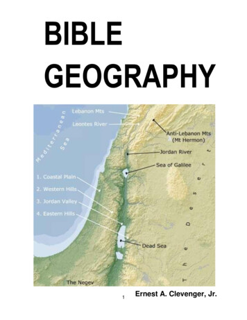
BIBLE GEOGRAPHYBy Ernest A. Clevenger, Jr.1. Eden - Adam and Eve.The exact location of the Garden of Eden is unknown. Some traditions place itbetween the Tigris and Euphrates rivers in an area also known as Mesopotamia(between the rivers). This was man‟s first home. It means “pleasure” or “garden ofMAP 1God.‟‟ Genesis 2:10f states, “And a river went out of Eden to water the garden; and fromthence it was parted, and became four heads. The name of the first is Pishon: that is ifwhich compasses the whole land of Havilah, where there is gold; and the gold of thatland is good: and there is bdellium and the onyx stone. And the name of the secondriver is Gihon: the same is it that compasses the whole land of Cush. And the name ofthe third river is Hiddekel: that is it which goes in front of Assyria. And the fourth river is10
the Euphrates.‟‟ Pishon means “freely flowing.” This may have been the Phasis riveralso called Araxes. Havilah means “circle‟‟ or “district.” It is described in Young‟sAnalytical Concordance as “The land of Chwalissi W. of Ural (?).” The Hiddekel Riveris the Tigris and means “rapid.” The fourth river, Euphrates, has retained its name. Theonly two places of certain that can be located are the Tigris and the Euphrates Rivers,and as may be observed on Map 1, page 9, both are very long. The location cannot begiven with certainty for the Garden of Eden. The teacher should examine Genesis 2:1524 in connection with Eden. Also, call attention to the fact that the tree of Life and thetree of the Knowledge of Good and Evil were planted in the garden. Cf. Revelation22:1-5.2. Euphrates River - Mesopotamia, Babylon, Garden of Eden.The Euphrates is the longest and most outstanding river of western Asia. Itmarks the western boundary of Mesopotamia; its‟ sister river, the Tigris, flows parallelmarking the eastern boundary. The Euphrates is given as the eastern bounds of thepromise made to Abraham (Genesis 15:18). It has played an important part in Biblehistory because it flows past the sites of Babylon and Ur. It is often referred to as the“Great River.” See Map 1, page 9. Note that the delta area of the two rivers is shadeddifferently. Some archaeologists believe this area in the last 3,000 years has filled in,and that the Persian Gulf was once open to Ur, which was a seaport town.3. Mount Ararat - Ark rested.The Hebrew literally means “the mountains of Ararat”. This is the area where theark built by Noah came to rest after the flood. Genesis 8:4. It is in the area now knownas Armenia. On Map 1, page 9, Ararat is indicated by an arrow pointing northward. Alarger map of the general area should be consulted for a better perspective.A. Settlement of descendents of Noah’s sons.Japheth - Europe. Based upon the statements in Genesis 10, theStory of the Bible World indicates the descendents of Japheth aspopulating the following areas: Europe, especially Tarshish (Spain) andAshkenaz (now France and Germany). Parts of the Balkans, Turkey,Kittim, Russia and Iran.Ham - Africa. The Story of the Bible World shows the descendentsof Ham as occupying Libya, Mizraim (Egypt), Cush (Ethiopia), Canaan,Crete, Philistia, and lower Arabia (Sheba).Shem - Near East. The Story of the Bible World shows that thedescendents of Shem moved to Arabia, Iran, western Turkey, and theupper Mesopotamian area. We can state for certain that the world wasrepopulated by the sons of Noah.11
4. Plain of Shinar - Tower of Babel.The Tigris and Euphrates rivers pass through this area, the “country of the tworivers”, before they reach the sea. Here the tower of Babel was built and the languageof men confused. Genesis 11. Later the area was known as Babylon. See Map 2.MAP 25. Uz - Job’s home.Named for the grandson of Shem (Genesis 10:23), it was the home of Job (Job1:1). The location of Uz is not certain, it was somewhere in the Syrian Desert.6. Ur - First Home of Abraham.The home of Terah and Abram; when Abram (Abraham) received his first callfrom God. Genesis 11:28, 31 and 15:7. Recent excavations have established the siteof Ur as being at what originally was the mouth of the Euphrates River, where the city12
probably was a seaport on the Persian Gulf. At this location a ziggurat (temple) hasbeen found where a moon god was worshipped. The age of the temple has beenestimated at older than 2,000 B.C.B. Points in Abraham’s Journey.Abraham is described in Genesis 11:31 as leaving Ur of theChaldees and going to Haran where he lived until his father, Terah, died.Next, in Genesis 12:1, God directs him to go to Canaan, which he did.Verse 10 tells of a famine in the land causing Abraham to go to Egypt for aperiod of time. Chapter 13 describes the return from Egypt to Canaan andthe wealth of Abraham. Map 1, page 9, shows the places and areascovered by the journey of Abraham: Ur, Haran, Canaan, Egypt and backto Canaan.7. Haran - Terah died, Nahor settled.Haran is a city of northern Mesopotamia bearing the name of Abram‟s brother. Itwas here that the father of Abraham died and where he received his first call from God.Abraham‟s brother, Nahor, and his descendents settled here. Genesis 24:10. Isaac‟swife, Rebekah, lived with her father, Nahor, in Haran. Genesis 24:24. Rebekah‟sbrother, Laban, and his family also lived in Haran. This is the city to which Jacob fledfrom Esau and where he married Leah and Rachel, daughters of Laban. Genesis 28:2f.It is also called Paddan-aram. “Paddan” is Arabic for “field” or “ploughed land”. See Map1, page 9, for location.8. Sodom and Gomorrah - Destroyed by fire and brimstone.Two cities of the plain of Jordan; both destroyed because of extremewickedness. Sodom is believed by some to have been located at the north end of theDead Sea. A modern theory, unproved, is that the Jordan once flowed into the Gulf ofAqaba and that Sodom and Gomorrah were cities at what is now the south end of theDead Sea; when God destroyed the two cities their destruction closed the valley,formed the Sea and reshaped the area. The two cities became the eventual home ofLot, Abraham‟s nephew. Lot, his wife and their two daughters were saved from thedestruction of the cities by God. Genesis19. In both the Old and New TestamentsSodom and Gomorrah are held up as a warning against sinning. See Isaiah 1:9;Matthew 10:15; 11:24; Romans 9:29; 2 Pet. 2:6; Jude 7.9. Beersheba - Home of Abraham and Isaac (Southern-most point).Beersheba was the principal home of Abraham and his son Isaac in the promisedland of Canaan. Genesis 21:31-34; 26:32, 33. The word “Beer” means “well.‟‟Beersheba has been translated as “well of seven.‟‟ Perhaps it gets its name from theagreement between Abraham and Abimelech being ratified by the seven lambs(Genesis 21:30). It is also sometimes translated “well of swearing‟‟ because of what is13
said in Genesis 21:31. Isaac dug a well at this location, Genesis 26:32, and thusnamed, Genesis 26:33. Because Beersheba represented the southern limit of the landof Israel, and Dan the northern most limit, the phrase „„from Dan to Beersheba‟‟ came tosuggest the entire nation. Cf. Judges 20:1.10. Mount Moriah - Abraham offered Isaac.This is the mount to which God led Abraham to offer his son Isaac. Genesis 22:2.Later, David purchased the area from Araunah (Ornan), 2 Samuel 24:24, and hereDavid‟s son, Solomon, built the temple, 2 Chronicles 3:1. When the area became a cityit came to be called Jerusalem. Today, in this place is a Moslem Mosque called the“Dome of the Rock” or, the “Mosque of Omar”.11. Dan - Temple ofJeroboam (Northern-mostpoint).MAP 3As was suggested inNumbers Nine, Dan was thenorthern-most landmark ofPalestine. It received itsname from the tribe of Dan,which took the city of Laishafter being displaced fromtheir original inheritance. Atan early date, the city wasthe center of idolatry andlater the Northern Temple ofJeroboamwaslocatedthere.Joshua 19:47;Judges 1:34; 13:2; 18:1-11.12. Salem - Abram metMelchizedek.In the days ofAbraham, Salem was asmall city kingdom hes.Genesis14:19. Melchizedek wascalled “priest of God MostHigh.” Genesis 14:18. Theword “salem” means “peace.” Many Bible scholars consider the area of Salem to have14
later become Jerusalem.Jerome thought Salem was some eight miles fromScythopolis or Bethshean. Evidence for the former location may be found in Psalms76:2 where Salem is used to refer to Jerusalem.13. Hebron - City of Caleb.Hebron, originally Kirjath-arba (Joshua 14:15), was the home of Abraham for atime. Genesis 13:18. It was in this area that Sarah died and was buried in the cave ofMachpelah. Genesis 23:2-20. Joshua 14:14 says Hebron became the inheritance ofCaleb, one of the faithful spies allowed to possess land in Canaan. Hebron was one ofthe most ancient cities, “built seven years before Zoan in Egypt.” Numbers 13:22. Thecity was the residence of David for more than seven years; here most of his sons wereborn and he was crowned king of Israel. 2 Samuel 2:2f. Cf. Genesis 35:27; 2 Samuel4:12. See Map 3, page 14.14. Gerar - Abimelech.This city, located to the south of Gaza, was very ancient; first mentioned inGenesis 10:19. Abimelech was king of Gerar during Abraham‟s residence there.Genesis 20:1f. It was to Abimelech that Abraham said his wife, Sarah, was his sister,and the king desired to marry her. This was a half-truth: Sarah was Abraham‟s halfsister, so he was not lying. The sin he committed was in not revealing that Sarah wasalso his wife. This is the same sin Abraham committed in Egypt (Genesis 12:10-20) andthe same sin Isaac committed in Gerar which was also stopped by Abimelech (Genesis26:1-1 1). Isaac was born in Gerar, Genesis 21:2, 3. He sowed the very fertile land(Genesis 26:12) which caused the Philistines to envy him (v. 14).15. Bethel - House of God.The name Bethel literally means “house of God.” This is strictly an OldTestament town; it is not mentioned in the New Testament. The original Canaanitename was “Luz”. The name Bethel was given to the place, located about twelve milesnorth of Jerusalem, by Jacob after his dream and receiving God‟s promise as recordedin Genesis 28:11-22. Notice verse 19. As Jacob returned from Haran he again went byBethel, Genesis 35:9-15. Cf. Hosea 12:2-6. A golden calf was set up at Bethel byJeroboam, 1 Kings 12:28, 29. Near here, a prophet was killed by a lion fordisobedience, 1 Kings 13:11f, and at Bethel the event in 2 Kings 2:23-25 of Elisha, thetwo she-bears and the forty-two children took place. For additional information seeAmos 3:14, 15; 2 Kings 17:28.16. Mizpah Jacob’s treaty with Laban.Mizpah means “watchtower” and was the name given the heap of stones piled upby Jacob an
The Bible, 1960: an history of the English Bible and annotated outline of its contents. The History of God People, 1963 Bible Geography, 1965 Jesus of the Bible, 1965 Wisdom Books of the Bible, 1966 Bible Doctrine, 1967 Bible Evidences, 1968 Bible Survey, 1969 Bible Characters, 1970 History of the Bible Chur