Transcription
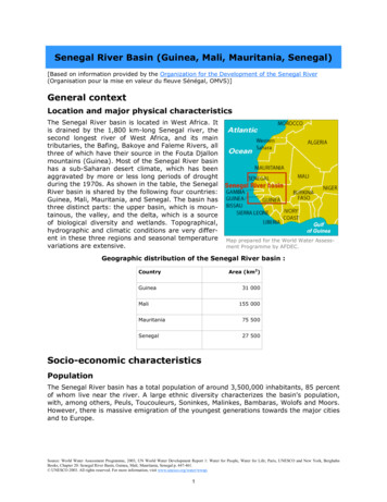
Senegal River Basin (Guinea, Mali, Mauritania, Senegal)[Based on information provided by the Organization for the Development of the Senegal River(Organisation pour la mise en valeur du fleuve Sénégal, OMVS)]General contextLocation and major physical characteristicsThe Senegal River basin is located in West Africa. Itis drained by the 1,800 km-long Senegal river, thesecond longest river of West Africa, and its maintributaries, the Bafing, Bakoye and Faleme Rivers, allthree of which have their source in the Fouta Djallonmountains (Guinea). Most of the Senegal River basinhas a sub-Saharan desert climate, which has beenaggravated by more or less long periods of droughtduring the 1970s. As shown in the table, the SenegalRiver basin is shared by the following four countries:Guinea, Mali, Mauritania, and Senegal. The basin hasthree distinct parts: the upper basin, which is mountainous, the valley, and the delta, which is a sourceof biological diversity and wetlands. Topographical,hydrographic and climatic conditions are very different in these three regions and seasonal temperaturevariations are extensive.Map prepared for the World Water Assessment Programme by AFDEC.Geographic distribution of the Senegal River basin :Area (km2)CountryGuinea31 000Mali155 000Mauritania75 500Senegal27 500Socio-economic characteristicsPopulationThe Senegal River basin has a total population of around 3,500,000 inhabitants, 85 percentof whom live near the river. A large ethnic diversity characterizes the basin's population,with, among others, Peuls, Toucouleurs, Soninkes, Malinkes, Bambaras, Wolofs and Moors.However, there is massive emigration of the youngest generations towards the major citiesand to Europe.Source: World Water Assessment Programme, 2003, UN World Water Development Report 1: Water for People, Water for Life; Paris, UNESCO and New York, BerghahnBooks, Chapter 20: Senegal River Basin, Guinea, Mali, Mauritania, Senegal p. 447-461. UNESCO 2003. All rights reserved. For more information, visit www.unesco.org/water/wwap.1
Agriculture: the main activity of the basinIrrigated agriculture rapidly expanded immediatelyafter the new dams were filled (between 1986 and1988). Today, irrigation is the motor of development in the basin, notably in the valley and in thedelta, due not only to improved technology, butalso to the wider variety of produce grown (rice,onions, tomatoes, potatoes, sweet potatoes). About100,000 hectares of land are now cultivated in thebasin: 60,000 hectares during the rainy season(June-September) and 20,000 during the dry season(March-June).Founded in 1659, on an island with a strategic position at the mouth of the Senegalriver, Saint-Louis is a town full of history.Livestock raising has also always been a major economic activity in the basin. Due to theexistence of rather high-potential pasture land, combined with the carrying capacity of thegrasslands and the flood plains, the riparian populations, and even those living elsewhere, practicetranshumance and extensive cattle, sheep and goatraising.Fishing, in terms of the income of the work forcethat it employs, is undoubtedly the largest economic activity in the basin after agriculture, notablyfor populations living near the river in the valleyand the delta. Today, however, the future of thissector is in question because for several years nowthere has been a steady drop in the tonnage caughtRice field in the Senegal River basin.throughout the OMVS region (i.e. the basin areashared by Mali, Mauritania and Senegal). Some observers link this to the river development projects (dams, dikes) and to their impact on the environment (significant decreasein salinity, proliferation of floating water weeds, eutrophication, etc.).Fisher on the SenegalSource: World Water Assessment Programme, 2003, UN World Water Development Report 1: Water for People, Water for Life; Paris, UNESCO and New York, BerghahnBooks, Chapter 20: Senegal River Basin, Guinea, Mali, Mauritania, Senegal p. 447-461. UNESCO 2003. All rights reserved. For more information, visit www.unesco.org/water/wwap.2
Other economic activitiesOperational since September 2001, the hydroelectric powerplant in Manantali had the following initial objectives: producing200 megawatts (Mw), to furnish an average of 800 giga wattper hour per year (Gwh/year) to electricity companies in thethree OMVS member states. These figures were based on hydrological data from 1950 to 1994, but new simulations donewith data from between 1974 and 1994 predict an energy production of only 547 Gwh. As a result of this decrease, the expected savings in OMVS member states expenditures for energy would unfortunately drop from 22 to 17 percent.The Manantali dam, built onthe Bafing River, is the largestin the basin.Navigation on the Senegal River is today very limited. The OMVS is aware of the strategicimportance of its development over the short term, and a navigation project is understudy. Like the exploitation of mineral resources, the ability to transport heavy goods at alower cost and, especially, access to the Atlantic Ocean for Mali could give a new impetusto the region's economy. Industrial sector is slightly developed.Water ResourcesHydrologyThe river's flow regime depends, for the most part,on rain that falls in the upper basin in Guinea(about 2,000 mm/year). In the valley and thedelta, rainfall is generally low and there is rarelymore than 500 mm/year. During the drought yearsof the 1970s, there was significantly less. The climatic regime in the basin can be divided into threeseasons: a rainy season, from June to September,a cold-dry off-season, from October to February,and a hot-dry off-season, from March to June. Thiscreates a high-water period or flood stage between The purpose of the Manantali dam is toJuly and October and a low-water period between attenuate extreme floods, generate electricNovember and May/June. The Manantali dam, built power and store water in the wet season.on the Bafing River, is the largest in the basin. Itspurpose is to attenuate extreme floods, generate electric power and store water in the wetseason to augment dry-season flow for the benefit of irrigation and navigation. The Diamadam, located near the mouth of the Senegal River in the delta, serves to block seawaterintrusion and thereby protect water and irrigation wells, and raises the level of the upstream water body, creating reserves to enable irrigation and double cropping.The water level in the alluvial aquifer varies with the seasons along with the general hydrological regime in the valley. Since the dams were filled, groundwater recharge and the piezometric surface have been significantly modified. Reducing the volume of the floods andbuilding dikes significantly reduces the area of natural recharge zones. On the other hand,flow regulation during low water periods and irrigation of large surfaces increases groundwater recharge during part of the dry season in some areas.Source: World Water Assessment Programme, 2003, UN World Water Development Report 1: Water for People, Water for Life; Paris, UNESCO and New York, BerghahnBooks, Chapter 20: Senegal River Basin, Guinea, Mali, Mauritania, Senegal p. 447-461. UNESCO 2003. All rights reserved. For more information, visit www.unesco.org/water/wwap.3
In some places, a degradation of surface water quality has been observed. This deterioration is caused primarily by eutrophication due to a reduction of the flow velocity and oxygenation of the water, due to the new dams and dikes, the proliferation of water weeds,and chemical and biological pollution related to the discharge of wastewater and pesticidesImpact of development on the population and on natural resourcesThe dam's implementation has both positive andnegative effects on the basin's population and natural resources. The Senegal basin's flood plain ecology has changed from a salty and brackish aquaticenvironment with marked seasonal changes to alow-flow perennial freshwater ecology. Some of themain negative effects are the displacement of populations, the degradation of the whole ecosystem,leading to the proliferation of water-borne diseases.However, the installation of the dams has enabled ayear-round availability of freshwater in sufficientquantities, and thus the development of irrigated agriculture in the valley, and access to drinking waterinstallations for populations living near the dams,among other things.Canalization of water to irrigate rice fieldsnear the Senegal River.Water ManagementPresentation of the OMVSThe OMVS river basin organization was established about three decades ago by three outof the four riparian states. Mali's principal interests are the maintenance of river levels soas to obtain navigable access to the sea and energy produced by the Manantali dam. Mauritanian and Senegalese interests converge in power production and irrigation, while Senegal seeks to improve livelihoods for local populations. These varied interests are typical ofa transboundary water management situation. The Manantali dam, although located inMali, belongs to all the members of the OMVS authority.The first institutions to develop the Senegal River valley were created during the colonialperiod. In 1963, shortly after independence, Guinea, Mali, Mauritania and Senegal signedthe Bamako Convention for the Development of the Senegal River Basin, that declared theSenegal River to be an 'International River' and created an 'Interstate Committee' to oversee its development. In 1968, the Labé Convention created the Organization of BoundaryStates of the Senegal River (OERS, Organisation des Etats Riverains du Sénégal) to replacethe Interstate Committee, broadening the field of subregional cooperation.Current approachThe OMVS's fundamental conventions of 1972 and the Senegal River Water Charter signedin May 2002, which establish its legal and regulatory framework, clearly state that riverwater must be allocated to the various use sectors. The resource is not allocated to riparian states in terms of volumes of water to be withdrawn, but rather to uses as a function ofpossibilities. The various uses can be for agriculture, inland fishing, livestock raising, fishfarming, tree farming, fauna and flora, hydroelectric energy production, urban and ruraldrinking water supply, health, industry, navigation and the environment.Source: World Water Assessment Programme, 2003, UN World Water Development Report 1: Water for People, Water for Life; Paris, UNESCO and New York, BerghahnBooks, Chapter 20: Senegal River Basin, Guinea, Mali, Mauritania, Senegal p. 447-461. UNESCO 2003. All rights reserved. For more information, visit www.unesco.org/water/wwap.4
The start-up of environmental monitoring by theObservatory represents golden opportunities forincreasing the involvement of representatives of thevarious stakeholders in the resource managementdecision-making process. This participatory approach will be reinforced by the launching of theMaster Plan next year.Fishermen spreading the catch of the day onthe beach.Main ProblemsDegradation of ecosystemsThe flood plain ecosystems have been most affectedby construction of the dams. In less than ten years,the degradation of these environments and the consequences on the health of the local populationhave been dramatic.Upstream of Diama, the functioning of regularlyflooded wetlands, lakes and ponds, like the Djoudj,Guiers Lake and Lake Diawling, has been seriouslydisrupted. After 1986, Diama dam blocked seawaterintrusion. The water above the dam is now freshSilvo-pastoral reserve in North Senegal.year-round, creating ecological conditions favouringthe proliferation of freshwater plants. These are veryinvasive and eutrophication has begun in some places in the valley and the delta. Downstream of the Diama dam, perturbations in the functioning of ecosystems takes the form ofan increase in salinity and/or a drying-up during part of the year (Ndiael wetlands) due tothe reduction of flooding or the destruction of water inflow channels during construction ofdikes, irrigated areas, etc. Anthropogenic pollution is caused by the discharge of industrialand agricultural chemicals into these environments.Other problems arise from increased competition for agricultural land and firewood. Asmarginal land on slopes and river banks is cleared, there is increased erosion. In addition,large areas of the basin have been denuded due to overgrazing.Source: World Water Assessment Programme, 2003, UN World Water Development Report 1: Water for People, Water for Life; Paris, UNESCO and New York, BerghahnBooks, Chapter 20: Senegal River Basin, Guinea, Mali, Mauritania, Senegal p. 447-461. UNESCO 2003. All rights reserved. For more information, visit www.unesco.org/water/wwap.5
Public healthThe degradation of the basin's ecosystems has affected the riverine population to various degrees.For example, there has been a drop in productivityin some economic areas (agriculture, fishing, livestock raising) compared to productivity during thefirst years after the dams were filled. This has ledto a decrease in income and, therefore, a decreasein the standard of living.The most serious problem that the basin has had toface since 1993/94, however, is the impact of theSheep drinking at a watering hole.dams on public health. There has been not only arapid increase in the prevalence of water-borne diseases that were already known in thearea (malaria, urinary schistosomiasis, diarrhoea, intestinal parasitic diseases), but alsothe appearance of intestinal schistosomiasis, a much more dangerous form of the disease.Useful linksRead the complete case study,velopment Report (WWDR1)published in the first edition of the UN World Water De-To know more about the Senegal basin, here is a list of interesting projects and organizations: Senegal Government : Presentation of the OMVS and Contacts. Food and Agricultural Organization (FAO) website : Presentation of The Senegal Riverbasin.The UN World Water Development Report, coordinated by the UN World Water AssessmentProgramme, is a joint effort of the 26 UN agencies and entities which make up UN-Water,working in partnership with governments, international organizations, non-governmentalorganizations and other stakeholders.For more information, visit our website at www.unesco.org/water/wwap.Source: World Water Assessment Programme, 2003, UN World Water Development Report 1: Water for People, Water for Life; Paris, UNESCO and New York, BerghahnBooks, Chapter 20: Senegal River Basin, Guinea, Mali, Mauritania, Senegal p. 447-461. UNESCO 2003. All rights reserved. For more information, visit www.unesco.org/water/wwap.6
onions, tomatoes, potatoes, sweet potatoes). About 100,000 hectares of land are now cultivated in the basin: 60,000 hectares during the rainy season (June-September) and 20,000 during the dry season (March-June). . UN World Water Development Report 1: Water for People, Water for Life;