Transcription
U.S. Department ofHomeland SecurityUnited StatesCoast GuardLIGHT LISTVolume VIPACIFIC COAST AND PACIFIC ISLANDSPacific Coast and outlying Pacific IslandsThis publication contains a list of lights, soundsignals, buoys, daybeacons, and other aids to navigation.IMPORTANTTHIS SHOULD BE CORRECTEDEACH WEEK FROM THE LOCAL NOTICES TO MARINERSOR NOTICES TO MARINERS AS APPROPRIATE.2022COMDTPUB P16502.6
LIMITS OF LIGHT LISTS PUBLISHED BYU.S. COAST GUARD180O160140OO120O100O80O60O6060OO5050OOVOL. VIIGREAT LAKESVOL. I40OATLANTIC COASTVOL. VVOL. VIMISSISSIPPIRIVER SYSTEMPACIFIC COASTAND PACIFIC ISLANDS40O(St. Croix River, ME to Shrewsbury River, NJ)VOL. IIATLANTIC COAST(Shrewsbury River, NJ to Little River, SC)MIDWAY ISLANDSVOL. IIIATLANTIC COAST(Little River, SC to Econfina River, FL)HAWAIIAN ISLANDSVOL. IVAids maintained atPuerto Rico, Virgin Islands,and Guantanamo Bayincluded in Volume III.GULF COAST20O(Econfina River, FL to Rio Grande, TX)AIDS TO NAVIGATION MAINTAINED BY UNITED STATES AT OTHERPACIFIC ISLANDS ARE INCLUDED ON THE PACIFIC LIST180O160O140O120O100O80O60O20O
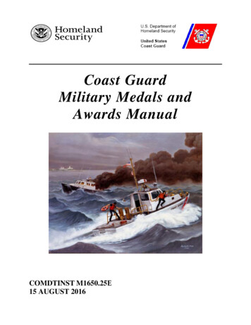
GU.S. AIDS TO NAVIGATION SYSTEMon navigable waters except Western RiversLATERAL SYSTEM AS SEEN ENTERING FROM SEAWARDPORT SIDEODD NUMBERED AIDSPREFERRED CHANNELNO NUMBERS - MAY BE LETTEREDGREEN LIGHT ONLYFLASHING (2)FLASHINGOCCULTINGQUICK FLASHINGISOPREFERRED CHANNELNO NUMBERS - MAY BE LETTEREDSTARBOARD SIDEEVEN NUMBERED AIDSPREFERREDPREFERREDRED LIGHT ONLYCHANNEL TOCHANNEL TOPORTFLASHING (2)STARBOARDTOPMOST BANDTOPMOST BANDGREENREDGREEN LIGHT ONLYFLASHINGOCCULTINGQUICK FLASHINGISORED LIGHT ONLYCOMPOSITE GROUP FLASHING (2 1)COMPOSITE GROUP FLASHING (2 1)9"2""1"FI G 6sLIGHTR "8"FI R 6sG "9"FI G 4sGR "A"FI (2 1) G 6sLIGHTED BUOYFI R 4sLIGHTRG "B"FI (2 1) R 6sLIGHTED BUOY9G"5"GC "9"GR"U"CANRGN "C"GRC "S"DAYBEACONCANRN "6"RG"G"R"2"NUNNUNDAYBEACONAIDS TO NAVIGATION HAVING NO LATERAL SIGNIFICANCEISOLATED DANGERNO NUMBERS - MAY BE LETTEREDSAFE WATERNO NUMBERS - MAY BE LETTEREDWHITE LIGHT ONLYWHITE LIGHT ONLYFI (2) 5sMORSE CODEMo (A)RW "N"Mo (A)LIGHTEDAND/OR SOUNDCBR "A"FI (2) 5sRW"A"BR "C"SPHERICALUNLIGHTEDAND/OR SOUNDRANGE DAYBOARDS MAY BE LETTEREDKGWLIGHTEDRW "N"RWSP BOARDS - MAY BE LETTEREDWHITE LIGHT ONLYSPECIAL MARKS - MAY BE LETTEREDNRNGNBYELLOW LIGHT ONLYFIXEDFLASHINGRWBnGWBnBWBnYYY "A"SHAPE OPTIONAL--BUT SELECTED TO BE APPROPRIATEC "A"N "C"BnFOR THE POSITION OF THE MARK IN RELATION TO THENAVIGABLE WATERWAY AND THE DIRECTIONOF BUOYAGE.UNLIGHTEDAids to Navigation marking theIntracoastal Waterway (ICW) displayunique yellow symbols to distinguishthem from aids marking other waters.Yellow triangles indicate aidsshould be passed by keeping them onthe starboard (right) hand of thevessel. Yellow squaresindicate aidsshould be passed by keeping them onthe port (left) hand of the vessel. Ayellow horizontal bandprovidesno lateral information, but simplyidentifies aids as marking the ICW.Y "B"FILIGHTEDTYPICAL INFORMATION AND REGULATORY MARKSNWINFORMATION AND REGULATORY MARKERSWBnWHEN LIGHTED, INFORMATION AND REGULATORYMARKS MAY DISPLAY ANY WHITE LIGHT RHYTHMEXCEPT QUICK FLASHING, Mo(A), AND FLASHING (2)BOATEXCLUSIONAREASWIMMOORINGBUOYWHITE WITH BLUE BANDMAY SHOW WHITEREFLECTOR OR N MAY BE PLACEDOUTSIDE THE CROSSED DIAMONDSHAPE, SUCH AS DAM, RAPIDS,SWIM AREA, ETC.THE NATURE OF DANGER MAYBE INDICATED INSIDE THEDIAMOND SHAPE, SUCH AS ROCK,WRECK, SHOAL, DAM, ETC.INFORMATIONMULLET LAKEWAKETYPE OF CONTROL IS INDICATEDIN THE CIRCLE, SUCH AS SLOW,NO WAKE, ANCHORING, ETC.BUOY USED TO DISPLAYREGULATORY MARKERSMAY SHOW WHITE LIGHTMAY BE LETTEREDBLACK RIVERFOR DISPLAYING INFORMATIONSUCH AS DIRECTIONS, DISTANCES,LOCATIONS, ETC.PLATE 1
122728213356432312VISUAL BUOYAGE GUIDE2REGION B - by dayPreferred ChannelSecondary ChannelREGION-B - by nightPreferred ChannelSecondary Channel3
FICTITIOUS NAUTICAL CHARTIT ET G UAD STES COASATRDUN1790"1"FI (2) G 6sG "7"FI G 4sR "2"ING "3""2"FI R 4s"2"Iso R 6sAL WATERWAYT R A C O ASTG "5"FI (2) G 6sRN "2"R "8"FI R 4s"1"Iso G 4sGC "3"R "6"FI (2) R 6sR "4"Oc R 6sIso R 6sG "3"BRFI (2) 5sR "2"QRG "3"FI G 6sRGFI (2 1) R 6sRWBnG "1"Iso G 4sR "2"FI R 6sRN "2"RWMo (A)GC "3"PLATE 3
GU.S. AIDS TO NAVIGATION SYSTEMon the Western River SystemAS SEEN ENTERING FROM SEAWARDPORT SIDEOR R IG HT DE S C E NDING B ANKGREEN ORWHITE LIGHTSRED ORFLASHINGISOLIGHTSTARBOARD SIDEOR LE FT DE S C E NDING B ANKPREFERRED CHANNELMARK JUNCTIONS AND OBSTRUCTIONSCOMPOSITE GROUP FLASHING (2 1)P R E FE R R E D C HANNE LTO S TAR B OAR DTOPMOST BAND GREENP R E F E R R ED C HANNELTO P OR TTOPMOST BAND REDFI (2 1) GFI (2 1) RFLASHING (2)ISOLIGHTED BUOYLIGHTCANLIGHTED BUOYJGWHITE LIGHTSNUNJRMAY BELIGHTEDCNGCNRTRSGPASSING DAYBEACONDAYBOARDS HAVING NO LATERAL SIGNIFICANCECROSSING DAYBEACONMAY BE LETTEREDCROSSING DAYBEACONPASSING DAYBEACONWHITE LIGHT ONLYNBA176.9123.5MILE BOARDMILE BOARDSPECIAL MARKS--MAY BE LETTEREDANYSHAPE: OPTIONAL--BUT SELECTED TO BE APPROPRIATEFOR THE POSITION OF THE MARK IN RELA TION TO THENAVIGABLE WATERWAY AND THE DIRECTIONOF BUOYAGE.BACUNLIGHTEDYELLOW LIGHT ONLYFIXEDFLASHINGMOORINGBUOYWHITE WITH BLUE BANDMAY SHOW WHITEREFLECTOR OR LIGHTLIGHTEDTYPICAL INFORMATION AND REGULATORY MARKSNWWHITE LIGHT ONLYSTATE WATERSINFORMATION AND REGULATORY MARKERSWHEN LIGHTED, INFORMATION AND REGULATORY MARKSMAY DISPLAY ANY LIGHT RHYTHM EXCEPT QUICK FLASHING, Mo(a)AND FLASHING (2)BOATEXCLUSIONAREADANG E R32CONTROLLEDAREADANGERSL OWROC KINLAND (S TATE ) WATE R S OB S TR UC TION MAR KMAY SHOW WHITEREFLECTOR OR QUICK FLASHING WHITE LIGHTSWIMNOAR E AEXPLAINATION MAY BE PLACEDOUTSIDE THE CROSSED DIAMONDSHAPE, SUCH AS DAM, RAPIDS,SWIM AREA, ETC.THE NATURE OF DANGER MAYBE INDICATED INSIDE THEDIAMOND SHAPE, SUCH AS ROCK,WRECK, SHOAL, DAM, ETC.WAK ETYPE OF CONTROL IS INDICATEDIN THE CIRCLE, SUCH AS SLOW,NO WAKE, ANCHORING, ETC.BLACK-STRIPEDWHITE BUOYMULLE T LAK EINFORMATIONBL AC K R IVERFOR DISPLAYING INFORMATIONSUCH AS DIRECTIONS, DISTANCES,LOCATIONS, ETC.BUOY USED TO DISPLAYREGULATORY MARKERSMAY SHOW WHITE LIGHTMAY BE LETTEREDUsed to indicate an obstruction to navigation,extends from the nearest shore to the buoy. Thismeans "do not pass between the buoy and thenearest shore." This aid is replacing the red andwhite striped buoy within the USWMS, but cannotbe used until all red and white striped buoys on awaterway have been replaced.PLATE 4
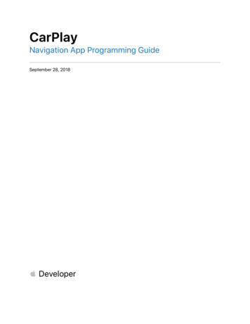
LUMINOUS RANGE DIAGRAMThe nominal range given in this Light List is the maximum distance agiven light can be seen when the meteorological visibility is 10 nauticalmiles. If the existing visibility is less than 10 NM, the range at whichthe light can be seen will be reduced below its nominal range. And, ifthe visibility is greater than 10 NM, the light can be seen at greaterdistances. The distance at which a light may be expected to be seenin the prevailing visibility is called its luminous range.This diagram enables the mariner to determine the approximateluminous range of a light when the nominal range and the prevailingmeteorological visibility are known. The diagram is entered from thebottom border using the nominal range listed in column 6 of this book.The intersection of the nominal range with the appropriate visibilitycurve (or, more often, a point between two curves) yields, by movinghorizontally to the left border, the luminous range.505040METEOROLOGICAL VISIBILITY98Code7LUMINOUS RANGE Nautical miles(This range may be reduced by the glare of other 23012345678less than 50 meters50-200 meters200-500 meters500-1,000 meters1-2 kilometers2-4 kilometers4-10 kilometers10-20 kilometers20-50 kilometersless than 50 yards50-200 yards200-500 yards500-1,000 yards1,000-2,000 yards1-2 nautical miles2-5.5 nautical miles5.5-11 nautical miles11-27 nautical miles9greater than 50 kmgreater than 27 nm106865434231120.80.610.40.31.2.METEORLOGICAL VISIBILITY(From International Visibility Code)0.203.0.1123 4 5 6 81015202530 35 40NOMINAL RANGE4.Nautical MilesCAUTIONWhen using this diagram it must beremembered that:The ranges obtained are approximate.The transparency of the atmospheremay vary between observer and light.Glare from background lighting willreduce the range that lights are sighted.The rolling motion of a vessel and/orof a lighted aid may reduce the distancethat lights can be detected or identified.20.80.61LUMINOUS RANGE statute miles2040(From International Visibility Code)(This range may be reduced by the glare of other lights)300.40.3METEORLOGICAL VISIBILITY(From International Visibility Code)0.200.1123 4 5 6 81015 20 25 30 3540 45NOMINAL RANGEStatute MilesGEOGRAPHIC RANGE TABLEThe following table gives the approximate geographic range ofvisibility for an object which may be seen by an observer at sea level. It isnecessary to add to the distance for the height of any object the distance corresponding to the height of the observer's eye above sea level.HeightFeet / MetersDistanceNautical Miles (NM)HeightFeet / 9.6140/42.7150/45.7200/61.0Example: Determine the geographic visibility of an object, with a heightabove water of 65 feet, for an observer with a height of eye of 35 feet.DistanceNautical Miles 316.5HeightFeet / MetersDistanceNautical Miles .729.831.033.135.137.0Enter above table;Height of object 65 feet 9.4 NMHeight of observer 35 feet 6.9 NMComputed geographic visibility 16.3 NM
This Page Intentionally Left Blank
TABLE OF CONTENTSLight List Regions. Inside Front CoverNAIS/LOMA base station map . iUSCG Contact Information . iiPreface. viiIntroduction . ixNAIS/LOMA base station map . .xliiSEACOASTCalifornia .1Oregon. 7Washington .8British Columbia .10Pacific Ocean . 11Alaska . 12BAYS, RIVERS, AND HARBORSSan Diego. . 15Los Angeles and Long Beach Harbor. 25San Francisco Bay . 35Humboldt Bay . 66Coos Bay . 71Columbia River.82Snake River . 110Grays Harbor . 133Strait of Juan de Fuca – Puget Sound . 137Strait of Georgia . 177Dixon Entrance. 183Stephens Passage . 195Prince William Sound . 217Cook Inlet. 223Alaska Peninsula . 232Hawai.i . 243Pacific Islands . 264INDEX . Index1CROSS REFERENCE .Cross Reference 1
This Page Intentionally Left Blank
Federal AIS ATON Broadcast SitesBroadcasts SitesLOMA & NAISLock Operations Management Application (LOMA)Nationwide Automatic Identification System (NAIS)i
The following is a description of the geographic coverage of each volume:VolumeIIIIIIIVVCoast Guard District(s)First Coast Guard District408 Atlantic AvenueBoston, MA 02110-3350 Tel: 617-223-8356http://www.uscg.mil/d1Fifth Coast Guard DistrictFederal Building 431 Crawford StreetPortsmouth, VA 23704-5004Tel: (757)398-6486 (757) 398-6552http://www.uscg.mil/d5Seventh Coast Guard DistrictBrickell Plaza Federal Building 909SE 1st Avenue; Rm:406Miami, FL 33131-3050Tel: (305) 415-6752 or (305) 415-6800http://www.uscg.mil/d7Eight Coast Guard DistrictHale Boggs Federal Building 500 Poydras StreetNew Orleans, LA 70130-3310Tel: (504) 671-2327 (504) 671-2137http://www.uscg.mil/d8Geographic DescriptionMaine, New Hampshire, Massachusetts,Vermont (Lake Champlain), Rhode Island,Connecticut and New York to ShrewsburyRiver, New Jersey.Shrewsbury River, New Jersey to LittleRiver South Carolina.South Carolina, Georgia, Florida toEconfina River (083 50' W), and PuertoRico and the U.S. Virgin Islands.Econfina River (083 50' W), Florida to RioGrande, Texas.Mississippi River system and its navigabletributaries, Tenn-Tom Waterway, Alabama,Atchafalaya, and the ApalachicolaChattahoochee-Flint River Systems.Eleventh Coast Guard District(California, Nevada, Utah, Arizona)Coast Guard Island Building 50-2 Alameda, CA94501-5100Tel: (510) 437-2975 http://www.uscg.mil/d11VIThirteenth Coast Guard District(Oregon, Washington, Idaho, Montana)Federal Building 915 Second Avenue 35thFloor, Rm3510 Seattle, WA 98174-1067Tel: (206)220-7270 (206) 220-7004http://www.uscg.mil/d13Fourteenth Coast Guard District(Hawaiian, American Samoa, Marshall,Marianas, and Caroline Islands)Prince Kalanianaole Federal Bldg.300 Ala Moana Blvd 9th Floor, Room 9-220Honolulu, HI 96850-4982Tel: (808) 535-3409(808) 535-3414http://www.uscg.mil/d14VIISeventeenth Coast Guard District(Alaska)PO Box 25517 Juneau, AK 99802-5517Tel: (907)463-2029 or (907) 463-2269http://www.uscg.mil/d17Ninth Coast Guard District1240 East 9th StreetCleveland, OH 44199-2060Tel: (216)902-6060 or (216) 902-6117http://www.uscg.mil/d9Pacific Coast, Pacific Islands, and the Coastof Alaska.Great Lakes and the St. Lawrence Riverabove the St. Regis River.ii
U. S. COAST GUARDELEVENTH DISTRICT UNIT LISTINGAIDS TO NAVIGATION TEAMSANT HUMBOLDT BAY200 New Navy Base Rd Bldg 8Samoa, CA95564-9999Tel:(707) 269-2550ANT LOS ANGELES/LONG BEACH1001 South Seaside Avenue Bldg 22San Pedro, CA90731Tel:(310) 521-3890ANT SAN FRANCISCOYerba Buena IslandSan Francisco, CA94130-5013Tel:(415) 399-3515ANT SAN DIEGO2710 Harbor DriveNorth San Diego, CA92101-1079Tel:(619) 683-6358BUOY TENDERSUSCGC GEORGE COBB (WLM 564)1001 South Seaside AvenueSan Pedro, CA90731Tel:(310) 521-4580USCGC ASPEN (WLB 208)c/o Coast Guard BaseYerba Buena IslandSan Francisco, CA94130-5013Tel:(415) 399-3590/91/92U. S. COAST GUARDTHIRTEENTH DISTRICT UNIT LISTINGAIDS TO NAVIGATION TEAMSANT ASTORIATongue Point FacilityAstoria, OR97103-2099Tel:(503) 325-3301ANT COOS BAYPO Box 5650Charleston, OR97420-0627Tel:(541) 888-3441ANT KENNEWICK434 Clover IslandKennewick, WA99336-3784Tel:(509) 586-1110ANT PUGET SOUND1519 Alaskan WaySouth Seattle, WA98134-1192Tel:(206) 217-6918iii
BUOY TENDERSUSCGC BLUEBELL (WLI-313)6767 North Basin AvenuePortland, OR97217-3992Tel:(503) 240-9362USCGC ELM (WLB-204)c/o CG Base Tongue PointAstoria, OR97103Tel:(503) 325-1601USCGC HENRY BLAKE (WLM-563)Naval Station Everett2000 West Marine View DriveEverett, WA98207Tel:(425) 304-5740U. S. COAST GUARDFOURTEENTH DISTRICT UNIT LISTINGAIDS TO NAVIGATION TEAMANT Honolulu400 Sand Island Access RoadHonolulu, HI96819-4398Tel:(808) 842-2851BUOY TENDERSUSCGC SEQUOIA (WLB 215)FPO AP 96678-3922Tel:(671) 355-4885U. S. COAST GUARDSEVENTEENTH DISTRICT UNIT LISTINGAIDS TO NAVIGATION TEAMSANT KODIAKP.O. BOX 195098Kodiak, AK99619-5098Tel:(907) 487-5181ANT SITKA613 Airport RoadSitka, AK99835Tel:(907) 966-5410iv
BUOY TENDERSUSCGC ANTHONY PETIT (WLM 558)1340 Stedman StreetKetchikan, AK99901Tel:(907) 228-0356USCGC ELDERBERRY (WLI 65401)PO Box 550Petersburg, AK99833-0550Tel:(907) 772-4225USCGC HICKORY (WLB 212)4688 Homer Spit Rd.Homer, AK99603-8001Tel:(907) 235-5233USCGC KUKUI (WLB 203)1480 Seward AvenueSitka, AK99835-9454Tel:(907) 966-5470USCGC SPAR (WLB 206)PO Box 190651c/o CG ISCKodiak, AK99169-0651Tel:(907) 487-5344USCGC SYCAMORE (WLB 209)PO Box 300Cordova, AK99574Tel:(907) 424-3434v
Light List Volume VIThis Light List is corrected through Coast Guard District Local Notice to Mariners No. 01/22, andNational Geospatial-Intelligence Agency (NGA) Notice to Mariners No. 01/22.The 2022 edition supersedes the 2021 edition.RECORD OF CORRECTIONS YEAR 2022 TO YEAR 252/22vi
PREFACELights and other marine aids to navigation maintained by or under authority of the U.S. Coast Guardand located on waters used by general navigation are described in the 7 volumes of the U.S. Light List.The Light List describes many aids to navigation owned or maintained by private entities; however, notall such aids are described.CAUTION: Mariners attempting to pass a buoy close aboard risk collision with a yawing buoy orwith the obstruction that the buoy marks. Mariners must not rely on buoys alone for determiningtheir positions due to factors limiting buoy reliability.PRIVATE AIDS TO NAVIGATIONClass I aids to navigation: These are aids located on marine structures or other works that theowners are legally obligated to establish, maintain, and operate as prescribed by the Coast Guard.These are included in the Light List.Class II aids to navigation: These are aids, exclusive of Class I, that are located in waters used by generalnavigation. These are included in the Light List.Class III aids to navigation: These are aids, exclusive of Class I and Class II that are located inwaters not ordinarily used by general navigation. These are not included in the Light List.LIGHT LIST AVAILABILITYThis Light List is annually published in electronic format and is intended to furnish more informationconcerning aids to navigation than can be conveniently shown on charts (U.S. Coast Guard Light Listvolumes can be found US Coast Guard Navigation Center website (USCG Light Lists). This Light Listis not intended to be used in place of charts or the United States Coast Pilot . Charts should beconsulted for the location of all aids to navigation. It may be dangerous to use aids to navigation withoutreference to charts.Note: NOAA has announced the phased shutdown of its traditional paper and raster chart productionsystem. Cancellation of traditional NOAA paper nautical charts, RNCs, and other associated raster chartproducts began in 2021 and will be completed by January 2025. Use NOAA ENCs for the most up-todate information.This list is corrected to the date of the notices to mariners shown on the title page. Changes to aids tonavigation during the year are advertised in U.S. Coast Guard Local Notices to Mariners and an updatedlist is posted every week on the USCG and National Geospatial-Intelligence Agency (NGA) MaritimeSafety Office’s Websites. Important changes to aids to navigation may also be broadcast through CoastGuard or Naval radio stations and NAVTEX. Mariners should keep their Light Lists corrected from thesenotices and should consult all notices issued after the date of publication of this Light List. Additionally,the U.S. Coast Guard maintains weekly updated Light Lists corrected through the current LNM week andare available in XML and PDF on the Weekly Light List Page of the U.S. Coast Guard NavigationCenter (NAVCEN) website.vii
IMPORTANT: A summary of corrections for this publication, which includes corrections from thedates shown on the title page to the date of availability, is advertised in the Local Notice to Marinersand the Notice to Mariners. These corrections must be applied to bring the Light List up to date.Additionally, this publication should be corrected weekly from the Local Notices to Mariners or theNotices to Mariners, as appropriate.Mariners and others are requested to bring any apparent errors or omissions in these lists to the attentionof the cognizant U.S. Coast Guard District or NAVCEN at TIS-SMB-NISWS@USCG.MILviii
INTRODUCTIONHow the Light List is ArrangedAids to navigation on the Coastal United States are listed in geographic order clockwise from north tosouth along the Atlantic coast, east to west along the Gulf of Mexico, and south to north along the Pacificcoast. On the Great Lakes, aids to navigation are listed from east to west and from south to north, excepton Lake Michigan, which is listed from north to south. Seacoast aids to navigation are listed first,followed by entrance and harbor aids to navigation, which are listed in the order proceeding towardsthe head of navigation from seaward.Names of aids to navigation are printed as follows to help distinguish immediately the type of aid tonavigation.Seacoast/Lake Coast LightsSecondary Lights, RACONSSound SignalsRIVER, HARBOR, OTHER LIGHTS, VIRTUAL AISLighted BuoysDaybeacons, Unlighted Buoys, Virtual Automatic Identification System (V-AIS) ATONLight List numbers are assigned to all Federal and Private aids to navigation for reference in the LightList. Aids to navigation are generally numbered by fives in accordance with their order of appearancein each volume of the Light List. Other numbers and decimal fractions are assigned where newlyestablished aids to navigation are listed between previously numbered aids to navigation. The LightLists are renumbered periodically to assign whole numbers to all aids to navigation.International numbers are assigned to certain aids to navigation in cooperation with the InternationalHydrographic Organization. They consist of an alphabetic character followed by three or four numericcharacters. A cross reference listing appears after the index.Description of ColumnsColumn (1):Light List Number.Column (2):Name and location of the aid to navigation.Bearings are in degrees true, read clockwise from 000 through 359 .Bearings on range lines are given in degrees and tenths where applicable.(C) indicates Canadian aid to navigation.Note: A dash (-) is used to indicate the bold heading is part of the name of the aid to navigation.When reporting discrepancies or making references to such an aid to navigation incorrespondence, the full name of the aid including the geographic heading, should be given.Column (3):Geographic position (WGS-84) of the aid to navigation in latitude and longitude.ixx
Column (4):Light characteristic for lighted aids to navigation.Column (5):Height above water from the focal plane of the fixed light to mean high water, listedin feet. For Volume 5 (Western Rivers), height above water is not indicated for aidsto navigation. Clearances for bridges, etc. are contained in the remarks column andindicate water level for each instance.For Volume 7 (Great Lakes), height above water from the focal plane of the fixed lightto low water datum, listed in feet and meters.Column (6):Nominal range of lighted aids to navigation, in nautical miles, listed by color for sectorand passing lights. Nominal Range is not listed for ranges, directional lights, or privateaids to navigation.For Volume 7 (Great Lakes), nominal range is expressed in statute miles.Column (7):The structural characteristic of the aid to navigation, including: dayboard (if any),description of fixed structure, color and type of buoy, height of structure above groundfor major lights.Column (8):Aid remarks, sound signal characteristics, including: VHF-FM channel if remotelyactivated, RACON characteristic, light sector arc of visibility, radar reflector,emergency lights, seasonal remarks, and private aid to navigation identification. AISspecific information may include its unique Maritime Mobile Service Identity(MMSI), the MMSI(s) of its source AIS transmission, and the application identifier ofany Application Specific Messages (ASM) it may also be transmitting.U.S. Coast Guard Light List DistributionU.S. Regulations require that most commercial vessels maintain on board a currently corrected copy orpertinent extract of the U.S. Coast Guard Light Lists, which are available for free and are updatedweekly on the Coast Guard Navigation Center’s website at USCG NAVCEN. For our policy on the useof electronic publications and charts, see Navigation and Vessel Inspection Circular (NVIC) 01-16 CH2 which can be found here: r/2010/ .Nautical Charts & PublicationsNautical charts covering the coastal waters of the United States and its territories are produced by theNational Oceanic and Atmospheric Administration (NOAA). These chart products include the NOAAelectronic navigational chart (NOAA ENC ), NOAA raster navigational chart (NOAA RNC ), andtraditional paper nautical charts. Information about ENCs may be found nc.html. Information about paper nautical charts andassociated raster chart products may be found here: charts.html.ENCs, RNCs, and traditional chart images may be downloaded from the NOAA Chart Locator at:xx
c.shtml. Paper copies of traditional nautical chartsmay be purchased from any of the NOAA certified chart agents listed s/print-agents.html#paper-charts.Note: NOAA has announced the phased shutdown of its traditional paper and raster chart productionsystem. Cancellation of traditional NOAA paper nautical charts, RNCs, and other associated rasterchart products began in 2021 and will be completed by January 2025. Use NOAA ENCs for the mostup-to-date information.Inland Electronic Navigational Charts (IENC) and chart books are published by the U.S. Army Corpsof Engineers (USACE) and are available online at https://www.agc.army.mil/echartsTide Tables and Tidal Current Tables are no longer printed or distributed by NOAA. NOAA Tide andCurrent predictions are available online at NOAA Tides & Currents. Commercially printed versionsthat use NOAA data are also available.Notices to MarinersSeveral maritime information products produced by the U. S. Government use some version of thename “Notice to” or “Notice to Mariners”. This section will describe each and explain how they can beobtained or accessed.U.S. Notice to Mariners, published weekly by the National Geospatial Intelligence Agency (NGA), isprepared jointly by the NGA, the U. S. Coast Guard, and the National Ocean Service. Its purpose is toprovide corrections to U. S. nautical charts used by ocean-going vessels, and corrections for a varietyof publications, including the U. S. Coast Pilot, NGA List of Lights, and the USCG Light List, amongothers. The Notice to Mariners also catalogues recent maritime safety information that has beendistributed for the benefit of oceangoing vessels. These include NAVAREA Warnings,HYDROLANTS,
U.S. Department of Homeland Security United States Coast Guard LIGHT LIST Vo