Transcription
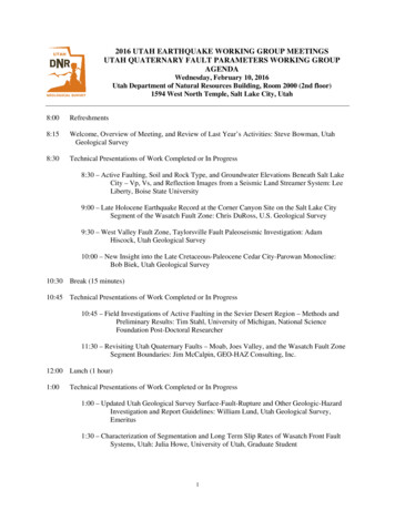
2016 UTAH EARTHQUAKE WORKING GROUP MEETINGSUTAH QUATERNARY FAULT PARAMETERS WORKING GROUPAGENDAWednesday, February 10, 2016Utah Department of Natural Resources Building, Room 2000 (2nd floor)1594 West North Temple, Salt Lake City, Utah8:00Refreshments8:15Welcome, Overview of Meeting, and Review of Last Year’s Activities: Steve Bowman, UtahGeological Survey8:30Technical Presentations of Work Completed or In Progress8:30 – Active Faulting, Soil and Rock Type, and Groundwater Elevations Beneath Salt LakeCity – Vp, Vs, and Reflection Images from a Seismic Land Streamer System: LeeLiberty, Boise State University9:00 – Late Holocene Earthquake Record at the Corner Canyon Site on the Salt Lake CitySegment of the Wasatch Fault Zone: Chris DuRoss, U.S. Geological Survey9:30 – West Valley Fault Zone, Taylorsville Fault Paleoseismic Investigation: AdamHiscock, Utah Geological Survey10:00 – New Insight into the Late Cretaceous-Paleocene Cedar City-Parowan Monocline:Bob Biek, Utah Geological Survey10:30 Break (15 minutes)10:45 Technical Presentations of Work Completed or In Progress10:45 – Field Investigations of Active Faulting in the Sevier Desert Region – Methods andPreliminary Results: Tim Stahl, University of Michigan, National ScienceFoundation Post-Doctoral Researcher11:30 – Revisiting Utah Quaternary Faults – Moab, Joes Valley, and the Wasatch Fault ZoneSegment Boundaries: Jim McCalpin, GEO-HAZ Consulting, Inc.12:00 Lunch (1 hour)1:00Technical Presentations of Work Completed or In Progress1:00 – Updated Utah Geological Survey Surface-Fault-Rupture and Other Geologic-HazardInvestigation and Report Guidelines: William Lund, Utah Geological Survey,Emeritus1:30 – Characterization of Segmentation and Long Term Slip Rates of Wasatch Front FaultSystems, Utah: Julia Howe, University of Utah, Graduate Student1
1:45 – Utah Quaternary Fault and Fold Database Status and Updates: Mike Hylland, UtahGeological Survey2:15 – New Utah Earthquake and Quaternary Fault Map: Steve Bowman, Utah GeologicalSurvey2:30 – Paleoseismic Investigation within the Traverse Ridge Segment Boundary: Initial Plansfor Summer 2016 Field Work: Nathan Toke, Utah Valley University2:45 – Reconnaissance Mapping of the Pots Creek Fault, Northeastern Utah: Joanna Redwineand Lucy Piety, U.S. Bureau of Reclamation3:00Break (15 minutes)3:15Technical Presentations of Work Completed or In Progress3:15 – The Great Salt Lake Fault and Its Microbial Mounds: Susanne Janecke, Utah StateUniversityUAV-Survey and Photogrammetry Produce LiDAR-Like DEM of Scarps in Logan,Utah: Susanne Janecke, Utah State University and Michael Bunds, JeremyAndreini, and Jack Wells, Utah Valley University3:30 – New Data on Holocene Offsets and Slip Rates for the Oquirrh Fault from DEMs Madewith Structure-from-Motion Methods: Michael Bunds, Jeremy Andreini, MichaelArnold, Kenneth Larsen, and Nathan Toke, Utah Valley University4:00 – Update on the Working Group on Utah Earthquake Probabilities (WGUEP) Report,Data Developed, and Outreach: Ivan Wong, AECOM (WGUEP Chair)4:15 – Basin and Range Province Seismic Hazard Summit III Summary: William Lund/SteveBowman, Utah Geological Survey4:30Working Group 2017 Fault Investigation Priorities DiscussionSee table 1 for the Utah Quaternary Fault Parameters Working Group (UQFPWG)list of faults requiring additional study, table 2 for the list of faults included in theUSGS National Seismic Hazard Maps and/or the UGS Hazus Utah fault database,table 3 for a status of current paleoseismic investigations for Utah priority faults andfault segments, and tables 4 and 5 for the UQFPWG 2016 fault priority list.5:00Adjourn2
Working Group MembersSteve BowmanRich BriggsMichael BundsDavid DinterChris DuRossAdam HiscockMichael HyllandSusanne JaneckeWilliam LundJohnny MacLeanJim PechmannSteve PersoniusJoanna RedwineNathan TokeIvan WongAdolph YonkeeUtah Geological Survey (UQFPWG Chair)U.S. Geological Survey, Earthquake Hazards ProgramUtah Valley UniversityUniversity of Utah, Department of Geology & GeophysicsU.S. Geological Survey, Earthquake Hazards ProgramUtah Geological Survey (UQFPWG UGS Liaison)Utah Geological SurveyUtah State UniversityUtah Geological Survey, EmeritusSouthern Utah UniversityUniversity of Utah Seismograph StationsU.S. Geological Survey, Earthquake Hazards ProgramU.S. Bureau of ReclamationUtah Valley UniversityAECOMWeber State UniversityPublicationsPaleoseismic investigations published by the Utah Geological Survey (UGS) are found in thePaleoseismology of Utah Series tion/paleoseismologyof-utah-series/). Most of the U.S. Geological Survey (USGS) National Earthquake Hazards ReductionProgram funded investigations for Utah that were not published by the UGS are compiled in UGSMiscellaneous Publication 13-03 p13-03.pdf).Utah Quaternary Fault and Fold DatabaseThe UGS updated the Utah Quaternary Fault and Fold Database on July 1, 2015, incorporatingnew data and a complete review of previously published data through the end of 2013. Users of anyQuaternary fault trace and related data acquired from the UGS or the Utah Automated GeographicReference Center (AGRC) State Geographic Information Database (SGID) in the past are advised to usethe updated database available from the AGRC SGID d-via-sde/) as the SGID10.GEOSCIENCE.QuaternaryFaults feature class. This single, comprehensivefeature class will be periodically updated as new/updated data become available (anticipated several timesper year) and replaces the six previously available feature classes of variable completeness. A web mapapplication for the database is available at faults/.Working Group Fault Study PrioritiesIn 2005, the UQFPWG developed a list of Quaternary faults and fault segments (table 1) that theworking group identified as requiring additional investigation to adequately characterize Utah’searthquake hazard to a minimally acceptable level. The list was expanded during subsequent UQFPWGmeetings in 2007, 2009, 2010, 2011, 2012, 2014, and 2015. Table 2 lists the faults and fault segments(earthquake sources) incorporated in the USGS National Seismic Hazard Maps and/or the UGS HazusUtah fault database (updated through 2013, UGS Open-File Report 631) not listed in table 1 that mayneed additional investigation. Table 3 lists the current status of paleoseismic investigations for priorityfaults and fault segments in table 1. Tables 4 and 5 list the 2016 UQFPWG priority faults and faultsegments. The UQFPWG will review the 2016 fault-investigation priorities and make changes asnecessary for the 2017 priority list.3
Table 1. Current list of Quaternary faults and fault segments identified by the UQFPWG as requiring additionalinvestigation to adequately characterize Utah’s earthquake hazard to a minimally acceptable level.Utah Fault or Fault SegmentNephi segment, Wasatch fault zone2,3West Valley fault zone2,3Weber segment, Wasatch fault zone2,3 – most recent eventWeber segment, Wasatch fault zone2,3 – multiple eventsUtah Lake faults and folds3Great Salt Lake fault zone2,3Collinston and Clarkston Mountain segments, Wasatch fault zone3Sevier and Toroweap faults2,3Washington fault zone3 (includes Dutchman Draw fault2)Cedar City-Parowan monocline3 and Paragonah fault2,3Enoch graben3East Cache fault zone2,3Clarkston fault2,3Wasatch Range back-valley faults (includes Morgan fault2 and Main Canyon fault3)Hurricane fault zone2,3Levan segment, Wasatch fault zone2,3Gunnison fault3Scipio Valley faults3Faults beneath Bear LakeEastern Bear Lake fault zone2,3Bear River fault zone2,3Brigham City segment, Wasatch fault zone2,3 – most recent eventCarrington fault, Great Salt Lake fault zone3Provo segment, Wasatch fault zone2,3 – penultimate eventRozelle section, East Great Salt Lake fault3Salt Lake City segment, Wasatch fault zone2,3 – northern partWarm Springs fault/East Bench fault2,3 subsurface geometry and connectionBrigham City segment, Wasatch fault zone2,3 rupture extent (north and south ends)Northern Provo segment, Wasatch fault zone2,3 – long-term earthquake recordTaylorsville fault, West Valley fault zone3Hansel Valley fault2,3Acquire new paleoseismic information to address paleoseismic data gaps for the five centralsegments of the Wasatch fault zone.Use recently acquired LiDAR data to more accurately map the traces of the Wasatch, West Valley,and Hurricane fault zones, and search for and map as appropriate previously undiscovered midvalley Quaternary faults.Acquire high resolution aerial imagery (LiDAR, Structure from Motion, etc.) and map high-risk(chiefly urban) Utah hazardous faults. Identify future paleoseismic trench sites.1 Original priorities from the 2005 UQFPWG meeting.2 Earthquake source on the USGS National Seismic Hazard Maps.3 Earthquake source listed in the UGS Hazus Utah fault database (UGS Open-File Report 631).4UQFPWG -2009-2010-2011-2011-2011-2011--2012--2014--2015
Table 2. Earthquake sources (faults and fault segments) in the USGS National Seismic Hazard Maps (NSHM) orthe UGS Hazus Utah fault database (UGS Open-File Report 631) not listed in table 1 and that may warrantadditional investigation.Utah Fault or Fault SegmentBeaver Basin intrabasin/eastern margin faultsCrater Bench/Drum Mountains fault zoneCrawford Mountains (west side)Cricket Mountains fault (west side)Fish Springs faultHouse Range (west side) faultJoes Valley fault zoneLittle Valley faultsMalad segment, Wasatch fault zoneMineral Mountains (west side) faultsNorth Promontory faultOquirrh fault zoneOquirrh-Southern Oquirrh Mountains fault zoneParowan Valley faultsPavant/Tabernacle/Beaver Ridge/Meadow-Hatton/White Sage Flat faultsPorcupine Mountain faultsScipio/Pavant Range/Maple Canyon/Red Canyon faultsSkull Valley faults (southern part)Snake Valley faultsSnow Lake grabenStansbury fault zoneStrawberry faultWah Wah Mountains (south end)West Cache fault, Wellsville sectionWestern Bear Lake fault5Included InNSHM Utah Yes-YesYesYes-Yes
Figure 1. Faults included in the UGS Hazus Utah fault database (updated through 2013, UGS Open-File Report631).6
Table 3. Current status of paleoseismic investigations for Utah priority faults and fault segments identified by theUQFPWG as requiring additional investigation to adequately characterize Utah’s earthquake hazard to aminimally acceptable level.UQFPWGPriority1Fault or Fault SegmentNephi segment, Wasatch fault zone5,61Granger fault, West Valley fault zone5,6Weber segment, Wasatch fault zone5,6 – most recent eventWeber segment, Wasatch fault zone5,6 – multiple eventsUtah Lake faults and folds6Great Salt Lake fault zone5,6Collinston and Clarkston Mountain segments, Wasatchfault zone6Sevier and Toroweap faults5,6Washington fault zone6East Cache fault zone5,6Wasatch Range back-valley faultsMain Canyon fault6Hurricane fault zone5,623456Levan segment, Wasatch fault789121415zone5,6Brigham City segment, Wasatch faultrecent event16zone5,6– most2007Bear River fault zone5,6Salt Lake City segment, Wasatch fault2007zone5,6– north partHansel Valley fault zone5,620092011Nephi segment, Wasatch fault zone5,6 – long-termearthquake recordProvo, Salt Lake City and Nephi segments, Wasatch faultzone5,6 segmentationInvestigationsStatus2,3 (as of 2/2016)Institution4UGS Special Study 124 and 151USGS SI Map 2966UGS/USGSUGS FTR ReportUGS Special Study 149UGS/USGSUGS Special Study 130UGS/USGSUGS Special Study 130UGS/USGSUUGG FTR ReportUUGG/BYUUUGG FTR ReportUUGGUGS Special Study 121UGSMap: UGS Open-File Report 638UGS Special Study 122UGSUGS Miscellaneous Publication 15-6UGSUSU FTR ReportUSUNo activity-UGS Miscellaneous Publication 10-5USBRUGS Special Study 119UGSUGS Map 229UGSMap: UGS Open-File Report 640UGS Special Study 142AGU Abstracts: 2012 and 2013USGS ongoingUGS Special Study 149McCalpin (1985), Robinson (1986),McCalpin and others (1992)UUGG ongoingUGS FTR Report2012USGS work ongoingUGS FTR ReportOngoingUGS Open-File Reports 638 and 640Additional work ongoingOne proposal funded (3DEP), secondproposal not funded.Flat, Maple, and Corner Canyons, and Alpine UGSFort Canyon fault, Traverse Mountains salientUVUUsing LiDAR to map portions of the Hurricane5,6,2014UGSWasatch5,6, and West Valley5,6 fault zonesAcquire high resolution imagery and map Utah hazardousUGS/State2015faults.of Utah1 See table 1 for complete working group priority list.2 FTR (Final Technical Report) to the USGS, Earthquake Hazards Program.3 Click on URL links to investigation report files available online.4 BYU (Brigham Young University), USBR (U.S. Bureau of Reclamation), USGS (U.S. Geological Survey, Earthquake HazardsProgram), UGS (Utah Geological Survey), USU (Utah State University), UUGG (University of Utah Department of Geology& Geophysics), UVU (Utah Valley University).5 Earthquake source on the USGS National Seismic Hazard Maps.6 Earthquake source listed in the UGS Hazus Utah fault database (UGS Open-File Report 631).7
Table 4. Utah Quaternary Fault Parameters Working Group 2016 list of highest priority Quaternary faults or faultsegments requiring additional investigation to adequately characterize Utah’s earthquake hazard to a minimallyacceptable level. The list will be reviewed at this meeting and revised as needed to develop the 2017 priority list.Fault or Fault Segment (Not in Priority Order)Acquire paleoseismic information to address paleoseismic data gaps for(1) the five central segments of the Wasatch fault zone, (2) theOquirrh fault zone, and (3) the East and West Cache fault zones.Examples of paleoseismic data to acquire include extent of surfacefaulting rupture, earthquake timing, displacement, and subsurfacefault geometry.InvestigationsStatus (as of 2/2016)1,2Nephi segment, Spring Lake andNorth Creek sites: UGS FTRReport, Special Study ongoingProvo segment, Flat Canyon site:USGS ongoing, UGS FTR ReportSalt Lake City segment, CornerCanyon site: ongoingProvo segment, Dry Creek and MapleCanyon sites: USGS ongoing, UGSFTR ReportFort Canyon fault, TraverseMountains salient: ongoingUGS Open-File Reports 638 and 640The UGS is currently mappingportions of the Hurricane, Wasatch,and West Valley fault zones.Use recently acquired LiDAR data to more accurately map the traces ofthe Wasatch, West Valley, and Hurricane fault zones, and search forand map as appropriate previously undiscovered mid-valleyQuaternary faults.Acquire earthquake timing information for the Utah Lake faults toinvestigate the relation of earthquakes on that fault system to largeNo activityearthquakes on the adjacent Provo segment of the Wasatch fault zone(independent or coseismic ruptures, fault pairs?).Acquire high resolution aerial imagery (LiDAR, Structure fromOne proposal funded (3DEP), secondMotion, etc.) and map high-risk (chiefly urban) Utah hazardousproposal not funded.faults. Identify future paleoseismic trench sites.1 FTR (Final Technical Report) to the USGS, Earthquake Hazards Program.2 Click on URL link to investigation report files available UVUUGS--UGS/Stateof UtahTable 5. Utah Quaternary Fault Parameters Working Group 2016 list of other priority faults or fault segmentsrequiring further investigation to adequately characterize Utah’s earthquake hazard to a minimally acceptablelevel. The list will be reviewed at this meeting and revised as needed to develop the 2017 priority list.Fault or Fault SegmentCedar City-Parowan monocline and Paragonah fault3,4Enoch graben5UQFPWGPriority11011Clarkston fault, West Cache fault zone3,413Gunnison fault4Scipio Valley faults4Faults beneath Bear Lake171819Eastern Bear Lake fault zone420zone4InvestigationsStatus (as of 2/2016)2Map: UGS Map 270Map: UGS Open-File Report 628UGS Special Study 98Fault trace mapping proposal notfunded.No activityNo activityNo activityFault trace mapping proposal notfunded.No activityNo activityCarrington fault, Great Salt Lake fault2007Rozelle section, Great Salt Lake fault zone4,520071 See table 1 for complete working group priority list.2 Click on URL link to investigation report files available online.3 Earthquake source on the USGS National Seismic Hazard Maps.4 Earthquake source listed in the UGS Hazus Utah fault database (UGS Open-File Report 631).5 Previous highest priority fault or fault segment.8InstitutionUGSUGSUGS---UGS---
Salt Lake City segment, Wasatch fault zone2,3 – northern part -- 2009 Warm Springs fault/East Bench fault2,3 subsurface geometry and connection -- 2010 Brigham City segment, Wasatch fault zone2,3 rupture extent (north and south ends) -- 2011 Northern Provo segment, Wa
