Transcription
United StatesDepartmentof AgricultureFIRE EFFECTS PLANNINGFRAMEWORKForest ServiceRocky MountainResearch StationGeneral TechnicalReport RMRS-GTR-163WWWUser’s GuideVersion 1.0October 2005Anne E. BlackTonja Opperman
Black, A.; Opperman, T. 2005. Fire Effects Planning Framework: a user’s guide. Gen. Tech. Rep.GTR-RMRS163WWW. Fort Colins, CO: U.S. Department of Agriculture, Forest Service, Rocky Mountain Research Station.63 p.AbstractEach decision to suppress fire reinforces a feedback cycle in which fuels continue to accumulate, risk escalates,and the tendency to suppress fires grows (Miller and others, 2003). Existing decision-support tools focus primarily on the negative consequences of fire. This guide outlines a framework managers can use to (1) identify key areas of fire risk and (2) systematically determine where and under what fire weather conditions fire will benefit ecological conditions and management targets while reducing fuels. The Fire Effects Planning Framework (FEPF)sequentially links state-of-the-art, publicly available analysis tools, data, and knowledge to generate GIS-basedplanning information for a variety of scales. Primary funding for this effort was provided by the Joint Fire ScienceProgram and the National Fire Plan.Keywords: fire, prescribed fire, wildland fire use, planning, fire effects, fuel treatment priorities, benefits, resource effects, FEPF, GIS, FLAMMAP, SIMPPLLE .AuthorsAnne E. Black is a post-doctoral ecologist with the Rocky Mountain Research Station at the Aldo LeopoldWilderness Research Institute in Missoula, MT. She completed a B.S. degree in resource conservation at theUniversity of Montana’s School of Forestry, a Master’s degree in Environmental Studies from Yale University, anda Ph.D. in ecology from University of Idaho.Tonja Opperman is a fire ecologist with the Bitterroot National Forest in Hamilton, MT. She earned a B.S. degree in Forestry from Michigan Technological University and a Master’s degree in Forest Science from YaleUniversity.AcknowledgementsTo develop and test this framework, we worked closely with fire and resource managers from a number of different agencies. Key among them are staff from the Bitterroot National Forest, Beaverhead-Deerlodge NationalForest, and Yosemite National Park. The guidebook has benefited from the critical reviews of Larry Bradshaw,Deb Tirmenstein and Mark Finney. Jimmie Chew provided advice during analysis. This document was producedas part of a Joint Fire Science Project: “Wildland Fuels: planning and evaluating benefits and risks.”You may order additional copies of this publication by sending yourmailing information in label form through one of the following media.Please specify the publication title and series number.Fort Collins Service CenterTelephoneFAXE-mailWeb siteMailing address(970) 498-1392(970) mPublications DistributionRocky Mountain Research Station240 West Prospect RoadFort Collins, CO 80526Rocky Mountain Research StationNatural Resources Research Center2150 Centre Avenue, Building AFort Collins, CO 80526
Fire Effects Planning Framework: Users GuideTable of ContentsI. The Fire Effects Planning Framework . 1Summary1Management questions addressed by FEPF3Model considerations5Software, skills and data requirements7II. Guide to FEPF using demonstrated models 9How to use this guide9Chapter 1. Developing rulesets to link fire behavior to fire effects.10Map ecosystem targets or processes11Define fire effects on ecosystem targets or processes13Define risk and benefit13Chapter 2. Creating map libraries for analysis of .16A. Current conditions using a stand-based, deterministic model161. Generating the landscape input file2. Generating fire weather input files3. Creating a fire behavior library4. Creating a fire effects libraryB. Current conditions using a landscape-level, stochastic model251. Parameterizing the model2. Creating fire type and probability maps3. Creating fire effects mapsC. Future conditions using a stand-based, deterministic model351. Creating a future vegetation cover2. Creating a future fuels cover3. Identifying changeD. Future conditions using a landscape-level, stochastic model381. Identifying and prioritizing stands2. Creating treatment schedules3. Creating fire type and probability maps4. Comparing fire type and probability mapsChapter 3. Using map libraries . . 48Support long-range management plan development48Support identification of fuel treatment priorities50Support fire stewardship activities51III. Forms .54
List of FiguresFigure 1. Basic elements of the Fire Effects Planning Framework process . .2Figure 2. Applications of Fire Effects Planning Framework output .4Figure 3. Crosswalk needed to determine fire effects . 11Figure 4. Illustration of concatenation field and join tables.12Figure 5. Overview of A current conditions using a stand-based deterministic model 17Figure 6. Generating weather and fuel moisture files for FLAMMAP.20Figure 7. Run FLAMMAP . 23Figure 8. Fire Effects Library using FLAMMAP 24Figure 9. Overview of B current conditions using a landscape-level, stochastic model . .25Figure 10. SIMPPLLE’s Fire Occurrence Input for entering fire history .27Figure 11. SIMPPLLE’s Fire suppression logic screens .28Figure 12. SIMPPLLE’s Weather ending event screens . .30Figure 13. SIMPPLLE’s Type of fire logic screen . 31Figure 14. Calculating probable fire type in SIMPPLLE . 34Figure 15. Overview of C future conditions using a stand-based, deterministic model . .35Figure 16. Illustration of the crosswalk between future vegetative conditions andFARSITE fuel layers . .37Figure 17. Overview of D future conditions using a landscape-level, stochastic model . 38Figure 18. Potential treatment priorities identified by proximity to the wildland-urbaninterface, stands ‘at risk’ of uncharacteristic fire and sensitive wildlifehabitat . .40Figure 19. SIMPPLLE’s Treatment Logic screen . 42Figure 20. SIMPPLLE’s Treatment Scheduler screen . . 43Figure 21. Example map of change in probability of Stand Replacing Fire .45Figure 22. Example map of change in most probable fire type using SIMPPLLE output . 47Figure 23. Using SIMPPLLE to compare probable fire effects under differentalternatives .49Figure 24. Illustration of how to query a fire behavior library to determine treatmentpriorities .51Figure 25. Illustration of potential use for WFIP/WFSA analysis. 52
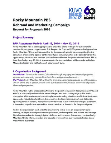
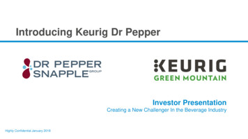
I. The Fire Effects Planning FrameworkSummaryEach decision to suppress fire reinforces a feedback cycle in which fuels continue toaccumulate, risk escalates, and the tendency to suppress fires grows (Miller and others2004). To make good decisions regarding fuels and fire, managers need to assess thebenefits, risks, and consequences of fire and fire suppression. Without information on thebenefits of fire, justifying wildland fire as a management strategy may be unpractical.The need for information is immediate, but existing decision-support tools focusprimarily on the negative consequences of fire.The challenge, then, is to create and institutionalize a more balanced analysis of fire (firestewardship), considering both ecological and social benefits and risks. The goal can befacilitated by using tools that managers already have and working within existingplanning and activity frameworks (e.g., using fire management and prediction tools toinform resource planning). Information on benefits must be available before majorplanning efforts (long-range planning, annual Fire Management Plan development,incident management). Additionally, information must be expressed in units that directlytranslate into those currently used to describe both land and fire management plans.These needs determined the focus of the Fire Effects Planning Framework (FEPF): to allow functional integration of fire and resource tasks; to express fire effects in terms meaningful to both fire and resourcestaff; and to enable immediate use by relying on existing tools and knowledge.The FEPF allows managers to systematically determine (map and quantify) where andunder what fire weather conditions fire is likely to create benefits or pose threats toimportant ecological conditions or management targets. FEPF1 is not a stand-alone tool;it is more of a conceptual model or ‘meta-model’ that sequentially links state-of-the-art,publicly available analysis tools, data, and knowledge to generate information for avariety of planning scales from long-range to site-specific. The key is to develop thisinformation in the off-season and have it available in digital and/or hard copy form fordecision-makers during the fire season.The process outlined by FEPF is straightforward (Figure 1): Map existing conditions of each planning target (fish and wildlife,vegetative condition, fuels, firefighter safety, and so forth);1FEPF does not provide special software; rather it outlines an analysis process using existing software to support strategic and tacticalfire planning.Fire Effects Planning FrameworkRMRS-GTR-163WWW1
Model fire;Identify how various fire behaviors (for example, surface vs. crownfire) are likely to affect targeted resources (causing a move towards oraway from desired condition) and capture this in database‘crosswalks’;Use these crosswalks to build GIS map libraries that display expectedeffects of fire on social and ecological values; andUse the resulting map libraries to: Assist in long-range planning, for instance to help analyzealternative management strategies; Assist in mid-range planning such as developing Fire ManagementPlans to identify potential Wildland Fire Use zones andprescriptions for the go/no-go decision; Assist incident support, for instance to identify where fire is likelyto provide benefits or pose risks to planning targets; Quantify the cumulative effect of a fire season on long-rangeplanning targets; Identify treatment priorities for the next season; and Determine feasibility of wildland fire use (WFU), prescribed fire(Rx), mechanical treatment, or suppression.Figure 1 - Basic elements of the Fire Effects Planning Framework process.One can operationalize FEPF in many ways and build numerous tools into theframework. In this guide we describe the framework and then illustrate the process usingexamples of both stand-based and landscape-level models. We take advantage of models2RMRS-GTR-163WWWFire Effects Planning Framework
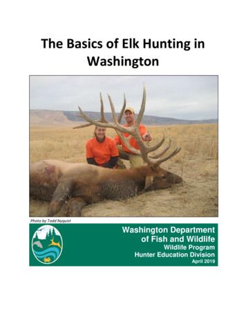
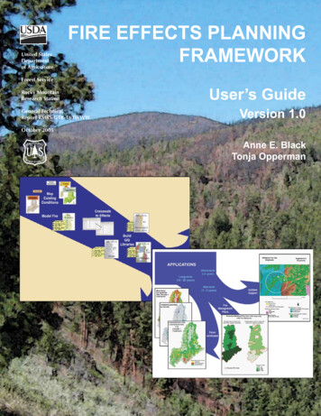
currently in use by regional fire and resource planners (FLAMMAP and SIMPPLLE,respectively). We do not claim that these are the ‘best’ tools for determining benefits andrisk; they are simply two models available now. Where tools are unavailable, others maybe substituted. Readers from these areas may still benefit from the overview andprocedural descriptions included in this guide. This guide is not intended to replace theuser’s guides or courses supporting individual programs that FEPF draws upon; instead,we offer it as a means to integrate existing programs to provide information none providealone.As with any analysis it is important to keep in mind key limitations of the models used.All models are simplifications of reality; none provides an infallible or complete pictureof the real world. Fire effects as predicted by the tools used here reflect currentknowledge of fire effects predominantly on above-ground biomass. They also assumethat fuels are homogeneous within a mapped unit – be that a polygon or a pixel. At thistime, we – as a management and scientific community – lack the ability to quantify,predict and spatially display ground2 fuels, ground fire behavior, or ground fire effects3.Thus, it is not possible in 2005 to accurately and consistently predict effects on soils at alandscape level, or to quantitatively predict whether a ‘surface’ fire is likely to result instand replacement of fire tolerant species due to ground fuel accumulation andconsumption. (As new information and new models become available, they can bereadily incorporated into FEPF.)Management Questions Addressed by FEPFFEPF produces information on the relative risks and benefits of fire under a variety ofdifferent conditions. Benefits and risks may be monetary or non-monetary. Monetarybenefits are most likely to result from reduced cost of future management or firesuppression efforts than from the sale of a commodity. We focus on non-monetarybenefits and risks. We define benefit as the number of acres that will be moved towardsor into a more desirable condition based on reference to the area’s targets found in longrange plans, Fire Management Plans, monitoring plans, and other targets such asmanagement indicator species. Risks are defined as undesirable effects resulting frommovement away from target conditions.FEPF’s output units are the same as those used by resource managers to track ecosystemtargets and by fire managers to evaluate fire behavior (for example, habitat or fuels).Resulting spatially explicit map libraries can support fire management decisions at manystrategic levels (Figure 2):2Ground fire is defined as fire in the upper, organic layers of the soil horizon, as distinct from surface fire which burns fuels on top ofthe soil and in the grass and shrub layer (see DeBano or Agee).3However, FOFEM5.0 begins to address this important issue.Fire Effects Planning FrameworkRMRS-GTR-163WWW3
Figure 2 – Applications of Fire Effects Planning Framework output.4 Planning (long-term, broad-scale): prediction, quantification, and mapping ofability to meet future planning targets under proposed and alternative firemanagement strategies. Includes monitoring and reporting of progress. How are proposed fire management tactics (suppression, prescribedfire, wildland fire use) likely to influence our ability to meet proposedresource targets in specific areas? Fire management plan (mid-term, broad-scale): delineation of wildland fireuse (WFU) fire management units derived from benefit/risk maps. Under particular weather conditions (for example, 80th percentileERC), where are there opportunities for WFU or prescribed fire? Fuels treatment (short to mid-term, fine-scale): identification andprioritization of areas (a) where treatment by fire (Rx or WFU) would assist inmeeting planning targets, and (b) where mechanical treatment is preferredfrom a fire behavior or ecological perspective. Where are fuel conditions such that mechanical treatments should beused before reintroduction/application of fire? Incident Support (short-term, fine-scale): identification and quantification ofecological benefits, such as changes in habitat or fuel profiles, forRMRS-GTR-163WWWFire Effects Planning Framework
development of Wildland Fire Implementation Planning (WFIP) Stage I, II, orIII, and Wildland Fire Situation Analyses (WFSA); identification of areaswhere light-handed suppression techniques may be most appropriate fromecological and cost-containment perspectives. Where are opportunities for accomplishing resource objectives,lowering costs of fire management, or creating fuel breaks forpopulated areas or areas of potentially severe fire behavior?Model ConsiderationsIdeally, FEPF would rest upon a model, or suite of models, that provide quantitativemeasures of the contagious processes involved in succession and disturbance (fire,disease, fuels, vegetation growth, and management) across the entire western UnitedStates. Unfortunately, although a rich variety of models is currently available, none can‘do it all’. Because users must choose from among existing models to populate FEPF,users should understand something about the strengths and weaknesses of models. Ourintent in this section is not to provide a comprehensive review of models – that is coveredelsewhere (see for instance Barrett 2001, Lee and others 2003) – but to raise a couple ofbasic differentiations users should consider before initiating analysis: contagion andvariability.In general, the choice of model to incorporate into FEPF is between a deterministic,stand-based model and a stochastic, landscape-based model. Landscape-level models (orlandscape dynamic simulation models, LDSMs) explicitly incorporate spread4 into thedetermination of stand conditions. Most LDSMs are stochastic, producing multipleoutcomes for a given set of inputs by varying the inputs according to some distribution.The distribution is often an estimation of natural variability. The advantage is thatincorporation of both experimental and experiential knowledge allows construction ofcomplex and often comprehensive system models. A key disadvantage is that it is notpossible to calculate significance or error measures for those parts of the model based onexpert opinion, and it is difficult to evaluate how closely predictions will emulate theactual future.Alternatively, stand-level models do not account for spread between stands but can oftenbe mapped spatially. Most stand-level models are deterministic. They produce a singleoutcome for a given set of inputs. Their advantage is that the significance and errorassociated with the experimental data are known. Their main weakness is that they mustoften greatly simplify the ecological processes of interest, incorporating only those piecesthat can be measured and controlled in an experiment. For both types of models, it isdifficult to disentangle error from variability. Further, when working with any type ofmodel, one must remember to treat results only as indicators of reality.4Spread, or contagion, refers to whether what is adjacent has an impact on behavior or processes within each polygon (stand) or pixel.Fire Effects Planning FrameworkRMRS-GTR-163WWW5
To determine which type of model best suits the user’s needs for FEPF, consider thesequestions: Where are you most comfortable accepting error/variability: incorporated into the outcome use a stochastic model, or excluded from the outcome use a deterministic model? Do you desire a quantitative measure of error possible for deterministic models, or of variability possible for stochastic models? Is your primary interest to develop information about the current situation either, or to compare results of alternative management strategies stochastic? How important is spread: can you accept stand-based predictions (no spread), or do you need to consider the influence of spread?We describe how to use FEPF with two models: a deterministic, stand-based model(FLAMMAP, Finney, in press), and a stochastic, landscape model (SIMPPLLE, Chew andothers 2004, Chew 1995). Though both are spatial, they have very different architectures.Briefly, FLAMMAP is a non-contagious, deterministic program based on empiricallyderived fire process/behavior equations (for example, Rothermel’s [1972] and Albini’s[1976] fire behavior equations).While it maps fire behavior across an entire landscape,calculations are performed on each pixel independently. FLAMMAP uses quantified fuelsinformation for a single point in time. To enable consideration of future fire behavior, avegetation simulator must be used to create future fuels data. Because FLAMMAP is basedon process equations, it is easily transported to any situation in which base data onvegetation and fuels are available. SIMPPLLE is a stochastic, contagious vegetationdynamics simulator developed from both empirical and knowledge-based sources. Itincorporates significant process variability (climate, fire weather, suppression efficiency,fire start location) and calculates fire effects by considering biophysical and vegetativeconditions in both the ‘initiating’ and ‘receiving’ polygons/pixels. SIMPPLLE does notgenerate or track quantitative fuels information, but because it incorporates fire effects, itcan be used to model either the current or future situations. Because SIMPPLLEincorporates significant local information about a number of complex ecosystemprocesses (insects, disease, fire) which science has yet to define or describemathematically at the landscape scale, SIMPPLLE must be parameterized locally(generally by forest or region, BLM Resource Area, or planning unit)5.We do not recommend use or avoidance of any particular model; nor will following thisprotocol provide a black-box that will give you the ‘right’ answer. Following theFramework will provide you with information relevant to your area and be useful to bothfire and resource management to aid in decision-making.5SIMPPLLE datasets have been created and parameterized for a number of National Forests and BLM Resource Areas around thewest, predominantly in the Northern Rockies, but including southern California, the Kenai and Michigan’s Upper Peninsula (Chewand others 2004).6RMRS-GTR-163WWWFire Effects Planning Framework
Software, Skills and Data RequirementsSoftwareFEPF requires several existing software programs. For all versions of the analysis, aspatial mapping program – such as ARCVIEW or ARCGIS – is required.To develop map libraries of fire behavior and fire effects programs : FIREFAMILYPLUS – to generate weather stream information for FLAMMAP; FLAMMAP – to generate fire behavior maps; and FARSITE – to generate weather files from the FIREFAMILYPLUS analysis.To generate information on potential future landscapes, or to consider current conditionsfrom a landscape perspective, you will also need a landscape dynamic simulation model(LDSM). For this document, we used SIMPPLLE, but are currently working with FVS-FFE as well. Other LDSMs,such as LANDSUM or RMLANDS, may also be used.To generate other fire effects, we used FOFEM for emissions and first order fire effectssuch as mineral soil exposed or soil heating. One can also build in sedimentation or runoff models. Disturbed-WEPP is an existing stand-based model.With the exception of the ESRI products (ARCVIEW, ARCGIS), all may be downloaded fromthe Internet at no cost (visit www.frames.gov, SIMPPLLE site). ESRI products areproprietary and should be obtained from your IT specialist. Contact the SIMPPLLEdevelopers group (Chew and others 2004) to determine whether SIMPLLE is available foryour area.Skills, expertise and timeWhile this guide is intended for both expert and casual users of the identified softwareprograms, a basic understanding of the tools is assumed. Although the fire-related toolsare easier to use “out of the box” than ESRI products (the ARC suite), consultation withfire experts is recommended to ensure proper identification of key parameters and modelspecification. Information in the detailed TASK sections provide tips on how toaccomplish each ACTION and assists in methodological consistency and documentation.The most time-consuming aspect of FEPF – and the one requiring coordination amongthe most people – is likely to be specification of fire effects. In the absence ofcomprehensive knowledge of fire effects based on experimental results, much of theinformation to build the fire behavior – fire effects crosswalks – will need to be inferredfrom available models, literature, and local knowledge. These crosswalks should bedeveloped with or reviewed by relevant experts.Fire Effects Planning FrameworkRMRS-GTR-163WWW7
DataFEPF input data are those required and/or developed during land management planningactivities: GIS data on vegetation, fuels, fire weather, fire occurrence, and hydrology, andresource targets for fisheries, wildlife, recreation and silvics, and so forth. The modelswe’ve used to operationalize FEPF will require manipulation of these general datasets asoutlined below.To develop planning target maps, you will need to identify characteristics of the targetthat can be linked to GIS map attributes (of vegetative, soils, and/or aquatic condition).To develop fire behavior maps with FLAMMAP you will need: Daily fire weather data. Daily weather data is processed throughFIREFAMILYPLUS to identify fire behavior parameters, such as Energy ReleaseComponent (ERC) values, at threshold fire weather conditions (for example,80th%, 90th%, 97th%, or 99th%). This information is then used to produce windand weather files for FLAMMAP.Digital DEM and fuels data. These include the necessary GIS grids to create aFLAMMAP landscape file (.lcp): fire behavior fuel model, canopy fuels data(stand height, crown closure, crown base height, crown bulk density); anddigital elevation models for calculating separate grids of aspect, slope, andelevation.To develop probability of fire, of fire type, and of return interval, using SIMPPLLE,you will need, in addition to a modified existing vegetation cover and a series ofparameter files for ecosystem processes (fire, insects/disease, succession): Historic fire starts. This cover is used to determine appropriate number ofstarts per simulation time step.Fire Management Units (or fire management zones, whichever is used fortactical decisions). This cover is used in combination with the historic startinformation to determine how to distribute starts spatially. Though a firemanagement zone map is most often used, one could just as easily use anecologically based map such as Potential Vegetation Type to distribute firestarts. This cover can also be used to calculate suppression costs.Land use. The FMU/FMZ or Land Use cover is used to specify type of firemanagement strategy (for example, Wildland Fire Use) and fire suppressionefficiency rates.To develop a map library of fire effects, you will need, in addition to the vegetationcover: Ancillary resource data. Additional data are used to predict probable locationsof management indicators or resource targets. Examples might be aspect,elevation, soils, or aquatic data.8RMRS-GTR-163WWWFire Effects Planning Framework
II. Guide to FEPF Using Demonstrated ModelsHow to Use This GuideThis guide is broken into two main sections: an overview of FEPF (above), and a guide toFEPF. The following guide is broken into three chapters covering: (1) development ofcrosswalks, (2) development of map libraries, and (3) use of map libraries. Chapter 2contains four non-sequential sub-sections outlining development of map libraries forcurrent and future conditions using both a stand- and a landscape-based model. Whichsub-section you choose in Chapter 2 depends on the type of analysis you wish to performand the model assumptions you are willing to accept: current condition analysis using a stand-based, deterministic model; 2A current condition analysis using a landscape-level, stochastic model; 2B future condition analysis using a stand-based, deterministic model; 2C future condition analysis using a landscape-level, stochastic model 2DWithin each chapter, we describe the Framework using three headings with an increasingorder of detail - ACTION, DISCUSSION, TASKS - to assist users of various skilllevels. This guide also provides a number of FORMS to assist in planning and trackinganalyses. EXAMPLES are offered to illustrate the ACTION.ACTION briefly identifies the task and outcome of the section. Users who have alreadygenerated this information or know how to use the programs utilized in the step can skipahead to the next ACTION. Such users may still be interested in reading the discussionsection to ensure that their existing data, or alternative method, include the informationnecessary in future steps. Information included under this section should also be helpfulin determining how outcomes might differ if alternative processes are used.DISCUSSION provides background on the goal of the action and identifies some ofthe alternatives and key assumptions.TASKS provide a more detailed step-by-step guide to generate the outcome usingspecified computer models or programs. This subsection is intended as a mechanicalguide to supplement the existing user’s guide for each program; it does not substitute forconsultation with the relevant expert or for training on the programs. Generation of eachoutcome may require consultation with local experts to determine parameters of interest,thresholds, and data sources.The FORMS subsection offers forms we have developed for collecting or evaluatinginput data.Fire Effects Planning FrameworkRMRS-GTR-163WWW9
We supplement the guide with sidebars using examples from our work on the BitterrootNational Forest.Chapter 1. Developing rule-sets (crosswalks) to link fire behavior tofire effects for each management targetFEPF uses effects of fire on ecosystem targets (for example, management goals orDesired Future Conditions/processes) as the criteria for evaluating the desirability of fire.This is calculated in a spatial context to allow easy quantification of benefits and risksand because many targets contain spatial criteria. Thus, it is important to be able to linksome critical aspect of the target or ecological process to a map-attribute affected by fire:vegetation, soils, water.Linkage of fire behavior to fire effects rests on the development of rule-sets, orcrosswalks. We found it helpful to break these crosswalks down into logical steps, firstassessing effects to vegetation, then basing species effects assessments on changes invegetation, and finally determining whether these changes are a benefit – movementtowards the desired condition, or a risk – movement away from target conditions.Following this logic, you will need to develop several crosswalks, which may becombined into a single crosswalk upon completion (Figure 3):(1) An initial crosswalk to identify how to map management targets spatiallyusing available d
sequentially links state-of-the-art, publicly available analysis tools, data, and knowledge to generate GIS-based . user’s guides or courses supporting individual programs that FEPF draws upon; instead, . be that a polygon or a pixel. At this time, we – as a management and