Transcription
Chapter 8Open ChannelsContents1.02.0Introduction . 1Natural Stream Corridors . 22.1 Functions and benefits of Natural Streams . 32.2 Natural Stream Corridors Prior to Urbanization . 42.3 Urban Stream Corridors . 52.3.1 Impacts and Constraints . 52.3.2 Stream Degradation. 53.0Preserving Natural Stream Corridors. 73.13.23.33.44.0Preserve Natural Streams and Riparian Vegetation . 7Provide Ample Space for Stream and Floodplain . 8Manage Increased Urban Runoff . 11Monitor and Proactively Address Channel Instability . 12Stream Restoration Principles . 134.1 Understand Existing Stream and Watershed Conditions . 144.2 Apply Fluvial Geomorphology Principles to Manage Sediment Balance . 174.2.1 Aggradation, Degradation, and Equilibrium . 174.2.2 Dynamic Equilibrium and Threshold Principles in Stream Restoration . 194.2.3 Support the Stream’s Natural Capacity to Sustain Itself . 204.3 Establish Effective Cross-Sectional Shape . 214.3.1 Maintaining Floodplain Function . 214.3.2 Sizing of Bankfull Channel . 224.3.3 Addressing Incised Channels . 244.3.4 Floodplain Terraces. 254.4 Maintain Natural Planform Geometry . 284.5 Develop Grade Control Strategy to Manage Longitudinal Slope . 304.6 Address Bank Stability . 354.6.1 Bioengineering Techniques . 354.6.2 Bank Protection Approaches . 354.7 Enhance Streambank and Floodplain Vegetation. 424.8 Evaluate Stream Hydraulics of over a Range of Flows . 445.0Naturalized Channels. 465.15.25.35.45.55.65.75.86.0Understand Existing Stream and Watershed Conditions . 46Apply Fluvial Geomorphology Principles to Manage Sediment Balance . 47Establish Effective Cross-Sectional Shape . 47Maintain Natural Planform Geometry . 48Develop Grade Control Strategy to Manage Longitudinal Slope . 48Address Bank Stability . 49Enhance Streambank and Floodplain Vegetation. 49Evaluate Stream Hydraulics over a Range of Flows . 49Swales . 506.1 Design Criteria for Swales . 51January 2016Urban Drainage and Flood Control DistrictUrban Storm Drainage Criteria Manual Volume 18-i
Open ChannelsChapter 86.1.1 Stability Charts . 516.2 Grass Swales . 526.2.1 Soil and Vegetation Properties. 526.2.2 Construction . 526.3 Soil Riprap and Void-Filled Riprap Swales . 527.0Hydraulic Analysis. 577.1 Preliminary Channel Analysis. 577.2 HEC-RAS Modeling . 587.2.1 Cross Section Location . 587.2.2 Cross Section Geometry . 597.2.3 Roughness Coefficients . 607.2.4 Design Storms . 637.2.5 Output Variables . 647.3 Evaluation of Erosion at Channel Bends. 688.0Rock and Boulders . 698.1 Riprap Sizing . 718.1.1 Mild Slope Conditions . 718.1.2 Steep Slope Conditions . 718.1.3 Design Safety Factor . 728.2 Boulder and Riprap Specifications . 728.2.1 Boulders . 728.2.2 Soil Riprap . 728.2.3 Void-Filled Riprap . 739.0References . 83TablesTable 8-1.Table 8-2.Table 8-3.Table 8-4.Table 8-5.Table 8-6.Table 8-7.Maximum prudent values for natural channel hydraulic parameters . 45Minimum dimensions for naturalized channels1 . 48Design parameters for naturalized channels . 50Summary of swale properties for stability chart reference . 51Recommended roughness values . 61Recommended retardance curve for vegetation in the Colorado Front Range . 62Comparison of void-filled riprap and soil riprap . 70FiguresFigure 8-1. Natural channel cross section illustrating floodplain terraces . 2Figure 8-2. Example sand-bed stream . 3Figure 8-3. Example upland channel. 3Figure 8-4. Functions and benefits of natural stream corridors (Source: Arapahoe County). 4Figure 8-5. Impacts of stream degradation (Source: Arapahoe County). 6Figure 8-6. Fourmile Canyon Creek, September 2013 flood impacts and floodplain. 10Figure 8-7. Importance of stream preservation zones . 11Figure 8-8. Planform geometry of a meandering river system. 15Figure 8-9. Lane’s diagram . 17Figure 8-10. Impact of channel geometry on velocity . 228-iiUrban Drainage and Flood Control DistrictUrban Storm Drainage Criteria Manual Volume 1January 2016
Open ChannelsChapter 8Figure 8-11. Channel cross section with bankfull discharge illustration . 23Figure 8-12. Channel cross section with bankfull and flood prone water surfaces (Rosgen 1996). 25Figure 8-13. Creating floodplain terrace in narrow corridor . 27Figure 8-14. Riffle-pool stream form . 29Figure 8-15. Example of meandering single-thread channel form (Courtesy: Wenk and Associates) . 30Figure 8-16. Full width grade control structures . 32Figure 8-17. Bankfull channel grade control structures . 33Figure 8-18. Example low-flow channel bank protection treatments . 36Figure 8-19A. Example bank protection treatments for steep eroded banks . 39Figure 8-19B. Example bank protection treatments for steep eroded banks . 40Figure 8-20. Sample soil lift section . 41Figure 8-21. Typical naturalized channel geometry . 47Figure 8-22. Swale stability chart; 2- to 4-foot bottom width and side slopes between 5:1 and 10:1 . 53Figure 8-23. Swale stability chart: 2- to 4-foot bottom width and 10:1 (or flatter) side slopes. 54Figure 8-24. Swale stability chart: greater than 4-foot bottom width and side slopes between 5:1 and 10:1. 55Figure 8-25. Swale stability chart: greater than 4-foot bottom width and 10:1 (or flatter) side slopes . 56Figure 8-26. Example of HEC-RAS cross section placement and alignment . 59Figure 8-27. HEC-RAS cross section definitions . 60Figure 8-28. Manning's roughness in vegetated channels . 62Figure 8-29. Example HEC-RAS tabular output for individual cross section. 65Figure 8-30. Example HEC-RAS tabular output for flow distribution at individual cross section . 66Figure 8-31. Example HEC-RAS cross section with velocity distribution . 67Figure 8-32. Example HEC-RAS general profile plot of shear stress . 68Figure 8-33. Small rock of void-filled riprap becomes “wedged in” under larger rock . 73Figure 8-34. Riprap and soil riprap placement and gradation (part 1 of 3) . 76Figure 8-34. Riprap and soil riprap placement and gradation (part 2 of 3) . 77Figure 8-34. Riprap and soil riprap placement and gradation (part 3 of 3) . 78Figure 8-35. Void-filled riprap placement and gradation (part 1 of 3) . 79Figure 8-35. Void-filled riprap placement and gradation (part 2 of 3) . 80Figure 8-35. Void-filled riprap placement and gradation (part 3 of 3) . 81Figure 8-36. Sample grouted boulder section . 82January 2016Urban Drainage and Flood Control DistrictUrban Storm Drainage Criteria Manual Volume 18-iii
Chapter 81.0Open ChannelsIntroductionThis chapter focuses on the preservation, enhancement, and restoration of stream corridors as well as thedesign of constructed channels and swales using natural concepts. Guidance is provided for the hydraulicevaluation of open channels and the design of measures to improve the stability and health of streamsystems. These measures include maintaining or establishing an effective planimetric channel form, crosssectional shape, and longitudinal slope; implementing grade control and bank protection; and establishingand maintaining a favorable mix of riparian vegetation. See the Hydraulic Structures chapter for varioustypes of structures with an open channels and the Stream Access and Recreational Channels chapter forcriteria related to the design of shared use paths adjacent to streams and criteria for responsible design ofrecreational channels including boatable channels. This chapter is organized as follows:Section 2.0 – Natural Stream Corridors. This section highlights the many functions and benefits ofnatural stream corridors then describes some of the threats to these natural systems that can be imposedby urbanization. Historically, urban impacts have included realigning or straightening streams, narrowingthe width of natural floodplains, and even replacing surface streams with underground conduits.Increases in runoff as a result of urbanization have contributed to degradation, aggregation, loss ofvegetation and habitat, and impaired water quality. This section introduces the concept of preservingnatural stream corridors and implementing techniques to restore stream functions. See the Planningchapter for techniques for implementing preservation.Section 3.0 – Preserving Natural Stream Corridors. This section recommends several key actions thatare necessary at the outset of development to preserve natural stream corridors. Preservation includesproviding ample room for the floodplain, reducing increases in urban runoff, and addressing problemsproactively. These actions can reduce impacts and provide for future stream management at a lower costand smaller footprint compared to constrained floodplains where elevated discharges must be conveyed innarrow corridors.Section 4.0 –Stream Restoration Principles. Eight principles of stream restoration are discussed toprovide design guidance for developers, engineers, ecologists, and others involved in the protection ofstream resources. The principles are valid for a variety of stream conditions, whether the corridor hasbeen preserved as described in Section 3.0 or constrained and impacted through urbanization. Specialdesign considerations are recommended for constrained urban stream reaches where velocities and shearstress imposed by elevated peak discharges are greater and infrastructure tends to be in close proximity tothe stream.Section 5.0 – Naturalized Channels. Sometimes streams need to be created where adequate channelconveyances do not exist. This section applies the principles of Section 4.0 to the design of naturalizedchannels. When designed with natural features, these channels can become established in a form that maybe indistinguishable from natural streams.Section 6.0 – Swales. As an alternative to storm drains, it is often desirable to create small surfacechannels, or swales, to convey runoff from small drainage areas. This section provides guidance for thedesign of grass and rock (soil riprap or void-filled riprap) swales.Section 7.0 – Hydraulic Analysis. This section provides guidance on the hydraulic analysis of naturaland constructed stream systems, emphasizing the use of HEC-RAS for hydraulic modeling.Section 8.0 – Rock and Boulders. The use of soil riprap, void-filled riprap, and boulders in streamrestoration and constructed channels is addressed in this section.January 2016Urban Drainage and Flood Control DistrictUrban Storm Drainage Criteria Manual Volume 18-1
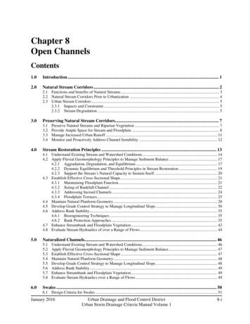
Open Channels2.0Chapter 8Natural Stream CorridorsNatural stream corridors, as illustrated in Figure 8-1, often contain a primarily non-vegetated bankfullchannel that may flow continuously or ephemerally within adjacent vegetated floodplain terraces (alsocalled benches or overbanks) and higher outer banks. An appropriately sized single-thread channel withfloodplain terraces creates favorable conditions at baseflows, producing greater depth, lowertemperatures, and better aquatic habitat. The spilling of flows out of the bankfull channel onto widerfloodplain terraces provides important interaction between water, soil, and vegetation. As floodwatersspread out onto the floodplain terraces, energy is dissipated, riparian vegetation receives water, andsediment can be conveyed through the system.Figure 8-1. Natural channel cross section illustrating floodplain terracesNatural channels take other forms besides the appearance of the cross section in Figure 8-1. They may beinfluenced by a relatively high sediment load and have a wide, sandy bankfull channel as illustrated inFigure 8-2. Or they may be vegetated across the entire channel bottom, either with wetland species if thechannel is normally wet or transitional or upland species if it is normally dry. Figure 8-3 shows a dry,vegetated stream common to upland areas. These channels also function best when high flows are allowedto spread out over a wider floodplain. Natural steam channels are dynamic and change over time inresponse to hydrology, watershed conditions, and other factors. Large floods can result in rapid channelevolution/avulsion. When the floodplain is preserved, these natural changes have space to occur withlower potential for damage than channels that are constrained.During high flow events, the water level rises and spreads to a width and depth associated with a specificreturn period. Local, State, and Federal floodplain criteria are most commonly associated with the 100year event. In some cases, the 500-year event is mapped and human development is limited with respectto this criterion. The overall width of the stream corridor should be planned and designed to convey theselarge flood events that can and will occur.8-2Urban Drainage and Flood Control DistrictUrban Storm Drainage Criteria Manual Volume 1January 2016
Chapter 8Open ChannelsFigure 8-2. Example sand-bed streamFigure 8-3. Example upland channel2.1Functions and benefits of Natural StreamsHealthy streams and floodplains provide a number of important functions and benefits. These aresummarized below and illustrated in Figure 8-4.1. Stable conveyance of baseflows and storm runoff.2. Support of riparian vegetation.3. Creation of habitat for wildlife and aquatic species.January 2016Urban Drainage and Flood Control DistrictUrban Storm Drainage Criteria Manual Volume 18-3
Open ChannelsChapter 84. Appropriate management of energy during a wide range of flows.5. Promotion of infiltration, groundwater recharge, and exchange of surface and subsurface water in thehyporheic zone located under and adjacent to the low-flow channel (this exchange has been shown tobe an important beneficial biological process).6. Enhancement of water quality through reduced erosion and through vegetative filtering and soil-waterinteractions.7. Provision of corridors for trails and open space.8. Enhancement of property values and quality of life.Figure 8-4. Functions and benefits of natural stream corridors (Source: Arapahoe County)2.2Natural Stream Corridors Prior to UrbanizationNatural stream systems are dynamic, responding to changes in flow, vegetation, geometry, and sedimentsupply. In the absence of urbanization, these stream systems are generally free to undergo dynamicchange with little negative impact. A free, open, natural stream system is characterized by: Space to move and adjust,Capacity to convey floods,Natural flow regime of water and sediment,Channel form adapted to its flow regime, andRiparian vegetation established to suit the natural hydrology and soils of the corridor.Such streams, although subject to aggradation, degradation, and other channel adjustments, are generallyable to sustain themselves over the long term.8-4Urban Drainage and Flood Control DistrictUrban Storm Drainage Criteria Manual Volume 1January 2016
Chapter 8Open Channels2.3Urban Stream Corridors2.3.1Impacts and ConstraintsIn developing urban environments, the driving variables of flow, sediment movement, geometry, andvegetation can undergo significant and rapid changes, exaggerating and accelerating the kind ofadjustments the stream makes; as a result, streams in urban environments face threats that can degrade thefunctions and benefits highlighted in Section 2.1.In addition, urbanization often places homes, roadways, and infrastructure in close proximity to streamsand their floodplains, exposing them to risk of damage from channel movement, bed and bank erosion,and inundation with runoff and mud and debris during flood events. The encroachment of developmenton stream corridors can limit the allowable width and depth of floodplains, increase velocities and erosivepower of flood flows, and impose constraints on the type of improvements necessary to improve channelstability.2.3.2Stream DegradationUrbanization typically increases thefrequency, duration, volume, and peak flowrate of stormwater runoff. Based on areview of Colorado Front Range hydrologicanalyses, average annual runoff volumesand peak discharges in urban areas canincrease by an order of magnitude or morecompared to predevelopment conditions.The largest increases in volume and peakdischarge occur in the more frequent eventsthat comprise the critical stream-formingflows. In addition, by re-surfacing theground with pavement and landscaping andinstalling water quality and flood storagefacilities, urbanization can decrease thesupply of watershed sediment below predevelopment conditions.Photograph 8-1. Extreme degradation in an unstable channel.(Source: Arapahoe County)As a result of increased runoff and reduced sediment loading, urban streams tend to degrade and incisetoward a flatter slope as the channels seek a new condition of equilibrium to transport that water andsediment. An extreme example of degradation is shown in Photo 8-1. Degradation produces a number ofnegative impacts to riparian environments and adjacent properties. These are illustrated in Figure 8-5 anddescribed below.January 2016Urban Drainage and Flood Control DistrictUrban Storm Drainage Criteria Manual Volume 18-5
Open ChannelsChapter 8Figure 8-5. Impacts of stream degradation (Source: Arapahoe County)1. Removal of Riparian Vegetation and Wildlife Habitat. Erosion typically strips natural vegetationfrom the bed and banks of streams. This disrupts habitat for aquatic and terrestrial species and leavesthe stream exposed to further erosion damage.2. Increase in Flow Velocities. An incised channel concentrates runoff in a narrow, deep section andincreases flow velocities and shear stresses. Increased velocities continue to erode the channel.3. Damage to Infrastructure. Channel erosion can threaten utility lines, bridge abutments, and otherinfrastructure. Utility pipelines that were originally constructed several feet below the bed of a creekcan become exposed as the bed lowers. Damage to the utility lines can result as the force of water anddebris come to bear against the line. Channel degradation can expose the foundations of bridgeabutments and piers, leading to increased risk of undermining and scour failure during flood events.Erosion and lateral movement of channel banks can cause significant damage to properties adjacent tostreams, especially if structures are located in close proximity to the banks.4. Lowering of Water Table and Drying of Terrace Vegetation. In many cases, lowering of thechannel thalweg and baseflow elevation leads to a corresponding lowering of the local water table andless frequent flows on the floodplain terraces. Besides the loss of water storage, lowering the watertable can “dry-out” the terraces and can effect a transition from wetland and riparian species to weedyand upland species, harming the ecology of floodplain terrace areas. It should be noted that raisingthe degraded channel up again will raise groundwater levels closer to the surface and may impactproperties adjoining the floodplain.5. Impairment of Water Quality. The sediment associated with the erosion of an incised channel canlead to water quality impairment in downstream receiving waters. One mile of channel incision 5-feetdeep and 15-feet wide produces almost 15,000-cubic yards of sediment that could be deposited indownstream lakes and stream reaches. Along the Front Range of Colorado, these sediments typicallycontain naturally occurring phosphorus, a nutrient that can lead to accelerated eutrophication of lakesand reservoirs. Also, channel incision impairs the “cleansing” function that natural floodplainterraces can provide through settling, vegetative filtering, wetland treatment processes, andinfiltration.8-6Urban Drainage and Flood Control DistrictUrban Storm Drainage Criteria Manual Volume 1January 2016
Chapter 8Open Channels6. Increase in Capital and Maintenance Costs. Typical stabilization projects to repair eroded streamsrequire significant capital and maintenance investment; the more erosion, generally the higher thecost.Although degraded channels may eventually erode and widen to create new floodplain terraces at a lowerelevation following a process called the channel evolution model (CEM), this would damageinfrastructure and impact water quality in the process. Channel evolution is complex, and a number ofdifferent CEMs have been developed by fluvial geomorphologists to conceptually describe how streamstypical of the Colorado Front Range evolve (Watson 2002). Instead, stream restoration is encouraged.As discussed in Section 2.2, stream restoration is greatly facilitated if adequate stream corridors aremaintained.3.0Preserving Natural Stream CorridorsThe opportunity to preserve natural stream corridors typically comes only at the outset of planning in awatershed. Preserving natural stream corridors not only preserves valuable habitat and veget
2.0 Natural Stream Corridors Natural stream corridors, as illustrated in Figure 8-1, often contain a primarily non-vegetated bankfull channel that may flow continuously or epheme