Transcription
Early British Trackways,Moats, Mounds,Camps, and Sites.Alfred WatkinsResurrection PressProvidence: 2004!
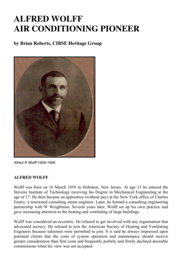
Early BritishTrackways, Moats,Mounds, Camps,and Sites.A Lecture given to the Woolhope Naturalists' Field Club, at Hereford,September, 1921, by ALFRED WATKINS, Fellow and ProgressMedallist (for 1910), of the Royal Photographic Society; PastPresident (1919) of the Woolhope Club. With illustrations by theAuthor, and much added matter.1922:HEREFORD: THE WATKINS METER Co.London: SIMPKIN, MARSHALL, HAMILTON, KENT & Co., LTD.1
2 Early British TrackwaysTABLE OF ILLUSTRATIONS.FRONTISPIECE. Top. Castle Tomen, Radnor Forest, 1,250 feet above the sea,and is supposed to be the Cruger Castle of the Itinerary of Giraldus.Background. A glade on a ley. Bottom. The Four Stones, New Radnor, theeasterly pair lined up for sighting over.PLATE I. PRIMARY PEAK. Titterstone Clee Hill, and Park Hall, Bitterley.PLATE II. MOUNDS. 1, Tre-fedw, Pandy. The Skirrid, a primary peak, indistance. 2, Didley. With homestead alongside.PLATE III. MOUND AND MOAT. 1, Houghton Mound. 2, Lemore Moat.Note how slight is the dividing line between this type of mound and amoat.PLATE IV. THREE-POINT PROOFS. 1 (a telephotograph), Hereford Cathedraland Pen-y-Beacon. Here the camera stood on a known ley in gateway neartop of Hafod Hill, and the line runs through pond at foot (marked by sheetof paper), tower of Cathedral, and the 20 mile distant mountain point orbluff. Another ley is seen crossing the meadow in a straight line just where" the lowing herd winds slowly o'er the lea." 2, Tre-fedw Mound (see PlateII.), shown at top of sighting line down present road to ancient Monnowford (alongside present bridge) at Llanvihangel Mill.PLATE V. SIGHTING CUTTINGS (all telephotographs). 1, Notch withearthwork at Trewyn Camp above Pandy (Black Mountains). 2, Cuttingthrough top of ridge at Marstow, a bridge now spans it, and the sightingline down to a ford on the Garron is indicated. The road beyond the cuttingis on the ley. 3, Black Darren, Longtown (Black Mountains). This is takenfrom the Tan House, Longtown, and only 100 yards to right or left thenotch begins to lessen and then disappear.
Alfred Watkins 3PLATE VI. CAUSEWAYS. 1, Through pond near Ten Houses (now PrioryTerrace), Helmer. Note the unmistakable direction, confirmed on map. 2,Through the River Monnow, behind Tan House, Longtown. A piece of fineengineering, the below-stream edge of large stones embedded in groutingor concrete. This ley is over the notch in Plate V.PLATE VII. CAUSEWAYS. 1, Over a ford of Olchon Brook, Longtown. 2,Ingestone, Ross. Through the "fold" and straight to the centre of the pondagainst the house. I cannot assign a period to any of these.PLATE VIII. LEYS DISPLAYED. 1, Rhiw (mountain track) south of LlanthonyAbbey, Mon. This is sighted for Balmawr on the ridge, and shows thatwhere possible even mountain side tracks were kept straight. Taken inevening light and shows (on left) the triple tracks down which it is surmisedthe tile stones for roofing the Abbey to have been slid from the quarry onthe top. 2, Stones at base of ancient Wye-side causeway at Bartonsham(formerly Bassam) Farm, Hereford City. The stones continue in a " washout " in bed of river to right, and the ley is sighted over tumps at HoggsMount and Holmer Lane. Note on' bank to right the mark-stone for theford (see Plate IX.).PLATE IX. MARK-STONES. 1, Red Lion, Madley. On a " red line " ley fromthe Whitney pottery. Note subsequent boundary stone alongside. 2,Credenhill. 3, Wye Street, Hereford, marking the Palace Ford ; there are apair of these stones. Bartonsham Farm, Hereford (see Plate VIII.).PLATE X. TRANSITION OF MARK-STONE TO CROSS. 1, Wergin's Stone,Sutton. With flat face suited for sighting. A cavity for payments (orofferings) on the flat base. Early example of " shaft and base." 2, PedlarsCross above Llanigon. A menhir chipped into rude semblance of a cross. 3,In churchyard, Vowchurch, unworked base. A ley runs through it. Inset,Sighting hole in shaft of Bitterley Cross. 4, In Capel-y-fin churchyard(Black Mountains).PLATE XI. CHURCHYARD CROSS. Bitterley (see Inset Plate X.). PI-ATE XII.TREE. Eastwood Oak, Tarrington, on a ley.PLATE XIII. TREES. 1, A " One Tree Hill '' near Llanvihangelnant-Melan. 2,Monnington Walks, an avenue of Scotch Firs (Scots Pines) on a ley sightedon Scar Rock, Brobury, men in distance. See Map, Plate XIX.
4 Early British TrackwaysPLATE XIV. CAMPS. 1, Sutton Walls. One of the sighting mounds, therebeing four, a pair at eastern end, a pair at this the western end. 2,Herefordshire Beacon. Winds Point to the left.PLATE XV. CHURCH. Church Lane, Ledbury. The detached tower of LedburyChurch is shown on the ley.PLATE XVI. CASTLE. Wigmore Castle. The keep is on a sighting mound, theley passing also through the church, as is almost invariable where castle andchurch are near together.PLATE XVII. CASTLE. Brampton Bryan Castle (on a sighting mound) withCoxall Knoll, another mound, in the distance on the right.PLATE XVIII. HOUSE IN MOAT. Gillow.PLATE XIX. MAP. TWO LEYS. A, Consecutive strips containing the straightley from Glascwm Hill to Birley Hill via four mounds ; Turret Tump, TheCamp, Batch Twt, Almeley, Moat, Sarnesfield Coppice ; and WeobleyChurch. B, Little Mountain to Holy Well Malvern, through Moccas "Castle " Tump, Preston-on-Wye Church, Byford Ford, Holmer Church,Palmer's Court, Moat, Shucknell, Walsopthorne. Portions of twointeresting leys are also shown. c, Scar Rock, Brobury, throughMonnington Walks to Monnington Church (see Plate XIII) ; and D, LittleMountain (Westbrook), through Arthur's Stone (dolmen), Cross End,Moccas Church, Monnington Church, St. Ann's Well, and Priory Church,Malvern.PLATE XX. MAP. Portions of eight leys passing through Capel-y-tair-ywen(Chapel of the three yew trees), a chapel site, originally a mound, describedin Woolhope Transactions, 1898, p. 38, on the high plateau below the greatnorthern escarpment of the Black Mountains. A, Hay Tump (near churchford) to Pen-y-Beacon, on to Castle Tump, Rhos-goch. B, Mouse Castle toTumpa, passes through Maes-coch (red field), Priory Wood, and the ancient" red " pottery, Whitney. c, Merbach to Llanelieu Church. D, Mynyddbrith Tump to Talgarth Church. E, Castle Tump, Dorstone, to Moat atFelin-fach. F, Snodhill Castle to Aberllynfi Gaer ; beyond Snodhill it passesto or through Holy Well, near Blakemere. G, Michaelchurch Escley toLlanigon Mound. H, Black Hill (Olchon) to Painscastle Mound.
Alfred Watkins 5FOREWORD.To the Average Reader.I judge that you pick up this booklet with much the same ideas on thesubject that I had a few months ago. The antiquarians had not helped you orme very much, but had left us with vague ideas and many notes ofinterrogation.On early trackways they alternated between a misty appreciation of hilltracks and ridgeways, and an implied depreciation of all trackmakers before theRomans came. To learn the meaning of mounds they did not go beyond thechild's investigation of a drum, cut it open to see; and, if nothing was there,quite failed to profit by such valuable negative evidence. In perhaps one moatin five they found a dwelling, and argued finely on the defensive importance ofa ring of water; but as to the other four; with no dwelling, and in unexplainedpositions, they closed their eyes.I do not know, dear reader, whether you will be as much astonished inreading the new facts which I disclose, and the deductions I feel obliged tomake, as I have been in the disclosure. Frankly, if another person told them tome, I should want to verify before acceptance. And I try to aid you to verify.But do note this—that the important point in this booklet is the previouslyundiscovered string of facts, which make it necessary to revise formerconclusions. My deductions may be faulty. But the facts are physical ones, andanyone can test in their own district whether moats, mounds and churches donot line up in straight lines with a hill peak at one end, and with bits of oldtracks and antiquarian objects on the line.So please do not begin with the false—as being inapplicable—word "theory." I had no theory when, out of what appeared to be a tangle, I got holdof the one right end of this string of facts, and found to my amazement that itunwound in orderly fashion and complete logical sequence.Make your own deductions when you have verified, and I have tried to helpyou.
6 Early British TrackwaysEARLY BRITISH TRACKWAYS.MOATS. MOUNDS. CAMPS AND SITES.Introduction.I have read of a lad who, idly probing a hill-side rabbit hole, saw a gleam ofgold, then more, and in short had found a royal treasury. And he could notshow all to those interested, but only samples, and he made mistakes indescribing the dates and workmanship of the coins, vessels and jewels. But thetreasure was there all the same.I knew nothing on June 30th last of what I now communicate, and had notheories. A visit to Blackwardine led me to note on the map a straight linestarting from Croft Ambury, lying on parts of Croft Lane past the Broad, overhill points, through Blackwardine, over Risbury Camp, and through the highground at Stretton Grandison, where I surmise a Roman station. I followed upthe clue of sighting from hill top, unhampered by other theories, found ityielding astounding results in all districts, the straight lines to my amazementpassing over and over again through the same class of objects, which I soonfound to be (or to have been) practical sighting points.For the sake of clearness I will give an outline of the whole method beforefurnishing proofs and examples.It is necessary first to clear the mind of present ideas of roads from town totown, or with enclosed hedges, also of any assumption that orderly roadplanning was introduced by the Romans, and that my paper is to explain theRoman roads.
Alfred Watkins 7Presume a primitive people, with few or no enclosures, wanting a fewnecessities (as salt, flint flakes, and, later on, metals) only to be had from adistance. The shortest way to such a distant point was a straight line, thehuman way of attaining a straight line is by sighting, and accordingly all theseearly trackways were straight, and laid out in much the same way that amarksman gets the back and fore sights of his rifle in line with the target.OUTLINE OF CONCLUSIONS.During a long period, the limits of which remain to be discovered, butapparently from the Neolithic (later flint) age on past the Roman occupationinto a period of decay, all trackways were in straight lines marked out byexperts on a sighting system.Such sighting lines were (in earlier examples) from natural mountain peakto mountain peak, usually not less than 1,000 ft., in this district, probablylower heights in flat districts, such points being terminals.Such a sighting line (or ley) would be useless unless some further markingpoints on the lower ground between were made. Therefore secondary sightingpoints were made, easily to be seen by the ordinary user standing at thepreceding sighting point, all being planned on one straight line. Thesesecondary, and artificial, sighting points still remain in many cases, either asoriginally made, or modified to other uses, and a large number are marked onmaps, and are the basis of my discovery.They were constructed either of earth, water or stone, trees being alsoplanted on the line. Sacred wells were sometimes terminals in the line, andsometimes included as secondary points.Between the sighting points the trackway ran straight, except in cases ofphysical impossibility, but did not of necessity go as far as the primary hilltops.Earth sighting points were chiefly on higher ground, and now, bear thename of tump, tumulus, mound, twt, castle, bury; cairn, garn, tomen, low,barrow, knoll, knap, moat and camp. Another form of earth sighting point wasin the form of a notch or cutting in a bank or mountain ridge which had to becrossed by the sighting line.Water sighting points seem to have evolved from the excavations made forthe tumps or moats. Almost all are on low ground, to form a point or ring ofreflection from higher ground, and are now known as moats and ponds.Stone sighting or marking points were natural (not dressed) blocks.
8 Early British TrackwaysSighting lines were (in earliest examples) up to 50 or 60 miles in length,later on rather shorter, down to a few miles.Sighting points were used for commerce and for assemblies of the people.When troublesome times came and stronger defences wanted, the groups oftwo or three sighting tumps which came near together (especially on the top ofa hill) often had defensive earthworks added to make a fortified enclosed camp.These trackways of successive ages grew so thick on the ground as to vie innumber with present day roads and by-ways.All forms of sighting points became objects of interest, superstition, andgenuine veneration, and as such were utilized on the introduction ofChristianity.Practically all ancient churches are on the site of these sighting points(tumps or stones), usually at a cross of tracks, and there is evidence that insome cases the churchyard cross is on the exact spot of the ancient sighting ormarking stone.In time, homesteads clustered round the sighting points, especially theponds.The moats and tumps were often adopted in after ages as sites for thedefensive houses or castles of wealthy owners.Hundreds of place names give support to these propositions.PROOF.The facts I have discovered, which lead up to the conclusions, can beverified for the most part on an inch to mile ordnance map with aid of astraight edge.Taking all the earthworks mentioned, add to them all ancient churches, allmoats and ponds, all castles (even castle farms), all wayside crosses, all crossroads or junctions which bear a place name, all ancient stones bearing a name,all traditional trees (such as gospel oaks), marked on maps, and all legendarywells. Make a small ring round each on a map. Stick a steel pin on the site of anundoubted sighting point, place a straight edge against it, and move it rounduntil several (not less than four) of the objects named and marked come exactlyin line.You will then find on that line fragments here and there of ancient roadsand footpaths, also small bits of modern roads conforming to it. Extend the lineinto adjoining maps, and you will find new sighting points on it, and it willusually terminate at both ends in a natural hill or mountain peak, or sometimes(in the later examples) in a legendary well or other objective.
Alfred Watkins 9If you travel along the actual sighting line you will find fragments of theroad showing as a straight trench in untilled land, although these are few andfar between, as the plough obliterates it all. The line usually crosses a river at aknown ford or ferry. Sighting tumps not marked on the map are also to befound.Two specific proofs are illustrated in Plate IV and explained in the Table ofIllustrations. Also from the highest point of the earthworks of Dinedor Campthe spire of All Saints' Church can be seen precisely between the pinnacles ofHereford Cathedral, thus showing a sighting tump and two churches on oneley. The Offa Street example (see under Churches) is another three-pointproof.THE LEY.The sighting line was called the ley or lay. Numbers of farms and places onsighting lines bear this first name, viz., the Ley Farms, Weobley, Grafton,Stoke Edith, and many other places. Wyaston Leys, Monmouth, Tumpey Leyand Red Lay, near Letton, and Redley in Cusop parish.There were cleverly planned high level mountain tracks which, although onan average sighting line, could not (being on the side of a mountain ridge) keepstraight, but took a serpentine course, in round the corms, and out round theheadlands. But viewed edgeways they are a straight line (see Plate VIII.) askeeping a uniform level or slope. Such are found high on the Malvern ridge,the road (on three leys) through Oldcastle to Blaen Olchon, the lovely BicknorWalks near Symonds Yat, the Precipice Walk near Dolgelly.There are signs of parallel trackways quite close together, whether one totake the place of an older one I do not know. And between Malvern Wells andHanley Swan are three symmetrical triangular woods (see Map, Plate XIX. ),which I find indicate parallel roads, one-sixth mile apart, running northwards,and with a collecting road here at right angles, which comes over the ridge andthrough Mainstone Court. There are six of these equidistant parallel roads.The fact of the ley is embedded in the rural mind. A country man indirecting your path will invariably bring in the now misleading, but oncecorrect, " keep straight on." It was once absolutely necessary to " keep straighton " in the ley, for if you did not you would be de-leyed on your journey. Thisis not said, as a pun, but as in some succeeding sentences, to point out the placeof the ley in the evolution of our language.Where the ley laid in a wood became a glade (see Frontispiece). We camethrough one over Worsell Wood in a Club excursion on our way to Gladestree.Where the ley had lain for a time often became a lane. This last noun became a
10 Early British Trackwaysverb used in the 18th century enclosure acts, where ground was "laned out."Where it was so laned out it became land. There is a Laynes Farm nearHuntley.It is still a common phrase to go out to see " the lay (or lie) of the land."The trackways are chiefly 6 feet 6 in. to 9 feet wide. I illustrate two pitchedcauseways at Longtown, a fine one through the Monnow near the Tan House,and the other close to a ford over Olchon Brook (Plate VI.). Another throughthe farm yard at Ingestone (Ross) going to the centre of the sighting pond(Plate VII.).ANTIQUITY OF THE LEY.The word " ancient " covers a vast period. If—as I have proved—the tumpsor burys are sighting tumps, excavations also prove that they usually date backto the Neolithic age, which, according to Mr. Ault's recent " Early Life inBritain," cannot be later than 2,000 B.C., and may be 4,000 B.C. A prehistorictrackway might, therefore, be planned and made more than three thousandyears before the Old Road (which is a route rather than a road) was devised orevolved as Mr. Belloc so well describes—as a Pilgrim's Way from Winchesterto Canterbury.I have found that the persistent things down the ages are not the courses ofthe roads or tracks, but their sighting points, and that cross roads with a placename are such. Place names are also persistent, some of them going back toprehistoric times, but others evidently mediaeval. But the real dating of theleys and when the system fell into decay is for future investigation.INDIVIDUALITY OF A LEY.Each ley or track was as separate and distinct from other legs as each animalor tree is an organism distinct from other animals or trees. As they crossedeach other, no doubt users often transferred from one to the other at thecrossing, and struck out in an altered direction, hence the place name element "turn." But the way thus travelled was a route, not a road. It is an absurdity tospeak of a sighted road having branches, or bending. Each individual track was" a long lane that has no turning."Previous writers, treating, say, of Roman or of mediaeval roads, notknowing of the existence of the ley, assume that they are speaking of originalprimary structures, when they are only describing a route evolved from a
Alfred Watkins 11number of the leys I describe, retaining the sighted structure in the case ofRoman roads, but losing most of it by mediaeval times.Many leys acquired in after ages individual names from the use they wereput to, and such names were transferred to the sighting points.I find in several cases a group of leys with sighting points passing quiteclose to, and taking no notice of, quite a distinct group of leys with othersighting points, the two sets being either of two different periods, or part ofseparate systems made by different sets of ley-men living in different districts.A most surprising fact is the enormous number of leys.MOUNDS.The mounds whose many names I have mentioned are artificial. I do notquestion the fact that they were often used as burial mounds, and perhaps evenbuilt with that end in view; but the straight leys on which I find practically allin this district line up (in connection with other sighting points) prove theirprimary purpose to be sighting tumps. Arthur's Stone, a dolmen, which wasprobably the core of a burial tump, is on two sighting lines.I find various stages of evolution of the tump. The small tump at a roadjunction for the local road construction, examples at Cross in Hand, Belmont,Hungerstone, Shelwick old Turnpike, near Bowley Town (called the Stocks).With most of these the pond from which the earth was dug adjoins. Whenmuch larger tumps were wanted the trench of earth to make them was dug inthe form of a ring, and a moated tump resulted, as at Eardisland (with water),Pont Hendre, Longtown (dry). The water in these excavations proved to besplendid sighting points by reflection from higher ground, and the moats withno tump but a flat plateau within a ring of water evolved. Many tumps onbanks, as at Tre-Fedw, near Pandy, show no excavations. Many tumps were atthe junction of leys, showing the technical skill of the early surveyors, whomust have moved a temporary sighting point on one ley until it fell in the lineof a second ley. A sighting tump always commanded a fine, clear view in atleast two directions, and in after ages was coveted as a dwelling spot. At Didleyis an instance of the simple homestead against it. Thus sighting produced thesites, this being only one of many instances where the record of the ley isembedded in the English tongue. The generic name of Merry Hill applied (asnear Hereford) to many tumps gives a clue to their use as assembly points forrecreation, confirmed by folk lore and surviving customs of dancing in a circlewith hands linked. The folk-mote was held at a tump with a dry moat, soadmirably adapted for seating.
12 Early British TrackwaysEARTH CUTTINGS.Where a mountain ridge stood in the path of a ley, the surveyor, 'instead ofbuilding a tump on the ridge as a sighting point, often cut a trench at the rightangle and in the path of the ley. This shows as a notch against the sky andmakes a most efficient sighting point from below. I have counted eight suchartificial notches in the mountain ridge when on the road from LlanvihangelCrucorney to Longtown. Each notch can only be seen on the line of sight, anddisappears when a quarter of a mile right or left. They are sometimesemphasised (as at Trewyn Camp) by an earth work thrown up on one side. TheWych on the Malvern ridge is an instance.The two fine gaps near Flansford (Goodrich) and Marstow (Plate V.), bothwith bridges over them, are also ancient sighting cuttings.The sighting cuttings were also used in passing over banks in lower ground.Cullis is one of the names for such an earth cutting, as Portcullis betweenWithington and Preston Wynne, and High Cullis above Gatley Park, recentlyvisited by the Club.There is a very neat example of such a cutting at Hungerstone, nearAllensmore, where the cutting in the bank allows the ley to be sighted on to apond on its way to the next tump, the one close to the church at Thruxton.The word hunger (a common place-name element) indicates, I think, acutting through a bank, not the bank itself, as now surmised. There are cuttingsat most fords, which permit the water to be seen from above and serve assighting points. The cutting near Charing Cross, which gives the name to thepresent Hungerford foot-bridge, probably came down through Inigo Jones'beautiful Water Gate.Mr. Codrington in his book on Roman Roads describes the method used byRoman engineers " well known to surveyors for laying out a straight linebetween extreme points not visible from each other, from two or moreintermediate points from which the extreme points are visible. By shifting theintermediate points alternately all are brought to lie in a straight line." Thismethod was evidently used for all the leys.WATER SIGHTING POINTS.I have suggested how these might have developed from the tump, andshown where pond and tump were used together. Moats are a similararrangement on a larger scale. The trackways go straight for the island part ofthe moat. It is not the least amazing part of this revelation that I find
Alfred Watkins 13practically all the small horse or cattle ponds in field or homestead which aremarked on a 6in. ordnance map have leys running through them, and thatexamination in dry seasons shows signs of the road passing through them."And when we cleaned the pond out we found it cobbled at the bottom" is afrequent report made by a farmer. I show a photograph of one of these atBridge Sollars, with the trench of the road beyond.A beautifully constructed causeway of even pitched stones is to be seen atthe foot of Holmer Hill (Plate VI.). It has well defined edges, and lies at thebottom of a small sighting pond. In the crevices of its stones I found fragmentsof crude red pottery, with a bit of early (Anglo-Saxon) ornament, a bit of ironslag, and a bit of iron. This ley is sighted on the North Hill, Malvern.I cannot say that passengers walked through the bottom of these ponds(most of them have one shelving edge, with the opposite bank steep), but tothis day an ancient road (at Harley Court, Hereford) does go through thebottom of a small pond, being sighted through the Cathedral.When there is a large central island on a moat I surmise early dwellinghouses—a subject for spade research. There evidently came a wish for roadsnot running through the water, and a pair of ponds or lakes with a causewaybetween, such as we find at Holmer fish ponds, is frequently found on the map,and is the sure indication of an ancient trackway. Probably the square moatsare later than the circular ones. I saw in the grass the track of a 15-foot road(probably Roman construction) making straight for the centre of YarkhillMoat.Many ponds (as at Belmont, The Burcot, and adjoining LedburyChurchyard) not known as moats are really such, their islands being sightingpoints.The causeway to the centre of the moat evidently suggested their use(many ages after they were made) as a defensive ring of the house of a richowner, as at Brinsop, Badesley Clinton, Gillow, etc.I think that the word lake, now used for large sheets of water, wasoriginally applied to small reflecting sighting ponds as well. The place names ofSutton Lakes, Withington Lakes, Letton Lakes, and Tumpy Lakes are explainedby this theory.MARK STONES.These (Plate IX.) were used to mark the way. They were of all sizes, fromthe Whetstone on Hargest Ridge to a small stone not much larger than afootball. Some were long stones or menhirs, but few remain upright in thisdistrict. I know of three lying fallen on leys, namely on the wall at the south
14 Early British Trackwaysgate of Madley Churchyard, near the inn at Bush Bank (cross road fromWeobley), and used as a bridge over a ditch near the Field Farm on the LitleyCarrots path.I show photographs of a fine stone at Red Lion, Madley, having a flat top,and of the type which developed into market stones. The market stone atGrosmont Town Hall (on which the first market basket placed on market daypaid no toll) is the successor of such a mark stone. Two marking stones (withancient brick houses built partly on them) stand unnoticed in the short WyeStreet, just over Wye Bridge at Hereford. They mark the Palace Ford, and a leyfrom Castle Hill to Hunderton. They are of the same peculiar stone (not "oldred") as at Madley, Colwall, etc.Wergin's Stone (Plate X.) is a late type of mark stone which was theprototype of the churchyard and wayside crosses, all of which I think are on thesites of original mark stones, as I find leys passing through them.In studying such crosses, I was puzzled to find several (as at Vowchurch,Hentland, Capel-y-fin) with ancient rough unworked stones as a base. I amnow certain that these bases are the original stones marking a ley. The Pedlar'sCross near Pen-y-lan Farm above Llanigon (mentioned in Miss Jacob's finestory, " The Sheep Stealers ") has been chipped into a rude suggestion of across without taking down, and a flat mark stone on which Archbishop Baldwinis said (by tradition) to have preached when on his tour with Giraldus in 1188,has had a cross inscribed on it. It stands close to St. Ishaw's Well at Partricio.There is a striking marking stone on the Rhiw Wen route in the BlackMountains.Other stones on leys are:—White Stone, Withington (with original stone atthe base of an inverted fragment of its successor a wayside cross) ; QueenStone, Huntsham, at Credenhill cross-roads, at the foot of Froom's Hill, on theroad near Turnaston Church, marking a ford at Bartonsham Farm, Hereford,and Crossways, Bollingham. The stone that all the Kings of England arecrowned on is certainly a mark stone.SIGHTING STONES.Mark stones may be on one side of the track, as are the whitewashed stoneswhich mark a coastguard's cliff walk to-day. But there also appear to have beensighting points of stone exactly on the ley, so constructed as to indicate itsdirection.The Four Stones near Harpton, New Radnor, are four upright boulders (seeFrontispiece) in an irregular quadrangle, and no one has explained theirpurpose.
Alfred Watkins 15I took sighting lines over successive pairs of stones, five lines beingpossible, and although the work on the map is not yet completed, I candefinitely say that the " Four Stones " are directing posts which point out atleast two lays, proved by passing through other good points. The first goes tothe highest point in Deerfold Forest (The Camp, 940ft.) in one direction; and inthe other through The Folly and on the main road at Llanvihangel-nant-Melan,over Bryn-y-Maen Hill, here appearing to strike another " four stones," andthrough Llansai
distance. The shortest way to such a distant point was a straight line, the human way of attaining a straight line is by sighting, and accordingly all these early trackways were straight, and laid out in much the same way that a marksman gets the back and fore sights of h