Transcription
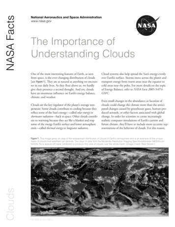
NASA FactsNational Aeronautics and Space Administrationwww.nasa.govThe Importance ofUnderstanding CloudsOne of the most interesting features of Earth, as seenfrom space, is the ever-changing distribution of clouds[see Figure 1]. They are as natural as anything we encounter in our daily lives. As they float above us, we hardlygive their presence a second thought. And yet, cloudshave an enormous influence on Earth’s energy balance,climate, and weather.Clouds are the key regulator of the planet’s average temperature. Some clouds contribute to cooling because theyreflect some of the Sun’s energy—called solar energy orshortwave radiation—back to space. Other clouds contribute to warming because they act like a blanket and trapsome of the energy Earth’s surface and lower atmosphereemit—called thermal energy or longwave radiation.Cloud systems also help spread the Sun’s energy evenlyover Earth’s surface. Storms move across the planet andtransport energy from warm areas near the equator tocold areas near the poles. For more details on the topicof Energy Balance, refer to NASA Facts 2005-9-074GSFC.Even small changes in the abundance or location ofclouds could change the climate more than the anticipated changes caused by greenhouse gases, human-produced aerosols, or other factors associated with globalchange. In order for scientists to create increasinglyrealistic computer simulations of Earth’s current andfuture climate, they’ll have to include more accurate representations of the behavior of clouds. For this reason,CloudsFigure 1. This image gives an idea of the widespread distribution of clouds in Earth’s atmosphere and is an example of the uniqueviews of clouds that satellites can provide. Two days of data from the Moderate Resolution Imaging Spectroradiometer (MODIS) onNASA’s Terra spacecraft were combined to produce this view of clouds over the whole Earth. (Image Credit: Reto Stöckli.)FS-2005-9-073-GSFC
The Importance of Understanding Clouds02clouds are an important area of study for the Earth-SunSystem Division in NASA’s Science Mission Directorate.Recipe for a CloudThe Right IngredientsClouds are collections of tiny particles of water and/orice that are large enough to be visible. What ingredientsare needed to make a cloud? The two required ingredients are water vapor and aerosols. Water vapor enters theatmosphere through evaporation from open water, thesoil, or the leaves of plants. The wind transports watervapor from one region to another through a processcalled advection. Aerosols come from natural sourcessuch as volcanoes or forest fires, as well as from humanactivities such as air pollution. Some aerosols are hygroscopic, meaning they readily absorb and retain water.Hygroscopic aerosols become the core, or nucleus, ofcloud droplets [see Figure 2], and so scientists call themcloud condensation nuclei or ice nuclei (nuclei is theplural of nucleus).The Right ConditionsSimply having moisture and aerosols present in theatmosphere does not guarantee a cloud will form. Toform an analogy to cooking, a bowl of flour, eggs, butter, and sugar will not come together to form a cakeunless the ingredients are combined under just the rightconditions. What conditions do we need to have present in the atmosphere for clouds to form?To answer this, we have to understand the concept ofstability—a measure of equilibrium illustrated in Figures3a and 3b with a simple system consisting of marblesFigures 3a (upper) and 3b (lower). The concept of stability can beillustrated using this simple system consisting of a bowl andmarbles. Figure 3a depicts a stable system. If the marble is givenan initial “push” in this environment, it moves for a time, but eventually returns to its initial position. On the other hand, Figure 3bshows an unstable system. If the marble is given an initial “push”in this environment, it continues to move. It doesn’t return to itsinitial position. (Image credit: Alex McClung.)and a bowl. Figure 3a illustrates the system in stable equilibrium. When the marble is disturbed, it may movearound for a while, but it quickly settles back to itsoriginal position. Figure 3b shows the system in unstableequilibrium. In this case, if the marble is disturbed, itwill continue to move away from its original position.The same idea can be applied to Earth’s atmosphere, butit is a little more complicated than the simple systemwith the marbles. To help us understand stability inEarth’s atmosphere, it’s helpful to define a parcel of air.The parcel is a thin bubble of air that doesn’t exchangeheat with the surrounding atmosphere so that we havewhat scientists call an adiabatic process. Since no othersources of energy are present, the parcel will expandand cool when it rises, and compress and warm when itlowers.Figure 2. Tiny water droplets begin to cluster around a hygroscopic (water attracting) aerosol and form a cloud droplet. If thisprocess continues long enough, the cloud droplets grow intoraindrops. A similar process allows ice crystals to grow. (Imagecredit: Alex McClung.)FS-2005-9-073-GSFCLike the simple system with the marbles, when the atmosphere is in stable equilibrium. A parcel of air givenan initial upward “push” in a stable air mass will tend toreturn to its original position. On the other hand, whenthe atmosphere is in unstable equilibrium, a parcel of
air given an initial upward thrust will tend to continue to rise.In the case of the marbles, the effects of gravity determined thestability of the system. What determines the stability of Earth’satmosphere?To determine stability in the atmosphere we have to compare thetemperature of a parcel of air to the temperature of the surrounding atmosphere. As we move higher and higher in the atmospherethe temperature usually decreases. The rate at which the temperature cools is called the environmental lapse rate. The rate at whicha parcel of air cools as it rises depends on the relative humidity ofthe air contained in the parcel. If a parcel has a relative humidityless than 100% we say it is dry. A dry parcel cools at a constantrate known as the dry adiabatic lapse rate and is equal to about 10 Celsius per 1000 meters risen. As the parcel continues its ascent,it continues to cool, and it has less and less capacity to holdmoisture. Eventually the parcel’s relative humidity reaches 100%and we say it is saturated. The temperature of the parcel when itbecomes saturated is called the dew point temperature.When a parcel cools to its dew point, cloud droplets begin forming as the excess water vapor condenses on the largest aerosolparticles. As the parcel keeps rising, more water condenses and thecloud droplets grow in size. If the droplets get large enough, theyfall out of the cloud as precipitation. The process of condensation releases heat into the parcel and the parcel cools at a new ratecalled the moist adiabatic lapse rate. Unlike the dry adiabatic lapserate, the moist adiabatic lapse rate varies greatly depending onthe temperature of the parcel. The warmer the air, the slower theparcel cools as it rises as heat released during condensation offsetsthe cooling. This means that the moist adiabatic lapse rate is muchless than the dry adiabatic lapse rate when the air is warm, but thetwo rates are nearly the same when the air is very cold.Stability in the atmosphere is defined by comparing the environmental lapse rate to the dry adiabatic lapse rate and moistadiabatic lapse rate. An absolutely stable atmosphere occurs whenthe environmental lapse rate is less than the moist adiabatic lapserate. Even a saturated parcel will be cooler than its surroundings atall levels and return to its original starting position. An absolutelyunstable atmosphere occurs when the environmental lapse rateis greater than the dry adiabatic lapse rate. Even an unsaturatedparcel continues to rise in this environment. In most cases, absolute instability is confined to a shallow layer of surface air on hotsunny days and only lasts for a short time. When the environmental lapse rate is somewhere between the moist adiabatic lapse rateand the dry adiabatic lapse rate, then the atmosphere is conditionally unstable. This means that the atmosphere’s stability is dependent on the moisture content of the air. If the air is dry, then theatmosphere is stable, but if the air is saturated, the atmosphere isunstable. The atmosphere is most often in a state of conditionalinstability.Atmospheric stability plays a major role in determining if cloudformation will occur on a given day. In general, an unstable orconditionally unstable atmosphere is more conducive to thedevelopment of clouds and precipitation. Sometimes a parcelcan be forced to rise in a stable environment, but the atmospherestrongly resists upward motion and any clouds that form areusually fairly thin and flat. An unstable atmosphere is necessaryfor the development of large convective clouds like those we seeduring thunderstorms.An Initial LiftInstability in the atmosphere makes the atmosphere conducive tocloud formation, but there still needs to be some mechanism thatgives the initial upward thrust to start the process. The most common lifting methods are: convection, convergence, lifting alongfronts, and lifting caused by topography. Each lifting mechanismcan result in clouds that have different physical characteristics.ConvectionA parcel may be heated by the Sun-warmed surface of Earth,become warmer than the surrounding atmosphere, and start torise—a process called convection. The rising air parcel becomesdiluted as it mixes with the surrounding air, losing some of itsbuoyancy. However, each successive air parcel following the samepath rises a little higher than the previous one. If a parcel riseshigh enough to cool to its dew point, the moisture within itcondenses and becomes visible as a cloud. On a hot summer day,the atmosphere will often start out clear, but the atmosphere isconditionally unstable, and cumulus clouds rapidly build as theday progresses and the sun heats the surface. If conditions aresufficiently unstable, these cumulus clouds can grow into toweringcumulonimbus clouds that produce thunderstorms and tornadoes.ConvergenceAnother process that lifts air from lower to higher altitudes is convergence, which is the “coming together” of surface winds. Whenair converges on a location, it can’t pile up there forever. Theconverging air must go somewhere, and from Earth’s surface, itcan only go up. Large-scale convergence can lift a layer of air thatis hundreds of kilometers across.As it does with convection, the air cools as it rises. If it cools toits dew point temperature, water vapor in the air condenses intocloud droplets. Uplifting of air that results from convergence isusually much weaker than uplifting from convection. As a result,clouds generated through convergence don’t usually build up intothe towering skyscrapers that convective clouds can become.Lifting Along FrontsLifting also occurs when air masses with different temperaturesand moisture content encounter one another. The type of cloudsthat form depends on whether a cold air mass runs into a warmair mass or whether a warm air mass runs into a cold one. Cold airis generally denser than warm air, and so it typically settles close toFS-2005-9-073-GSFC
The Importance of Understanding Clouds04Figure 4. When air encounters a mountain it can’t go through the mountain, so it rises. As it does, clouds and precipitation may fall onthe windward side of the mountain, while it tends to be dry on the leeward side. (Image credit: Alex McClung.)the surface. When a cold, heavy air mass moves towarda warm one, it takes the “low road” near the surfaceand forces the warm air up and out of its way. Theconvergence of a cold air mass into the space occupiedby a warm one can drive warm, moist air high into theatmosphere, forming tall cumulus clouds.warm front is gentler when compared with the liftingalong a cold front. Consequently, clouds formed fromthe convergence of a warm air mass into a cold one aremore widespread and not as tall, for example they willbe thin, wispy cirrus clouds or the cotton-blanket-likestratus clouds.In contrast, when the leading edge—the front—of awarm air mass nudges against a colder, denser air mass,the cold air mass acts like a boulder in a river. When thewarm front reaches the cold air mass, the warm, lighterair cannot budge the cold air out of the way. Instead,it climbs up and over the edge of the cold air mass.Because warm air is less dense, the lifting of air along aLifting Caused By TopographyWhen moving air encounters a mountain or a mountain range, the air is forced up the mountain’s slopes.Atmospheric scientists call the process orographic lifting.(Orographic means “having to do with or influencedby a region’s mountains or elevated terrain.”) As airascends the mountain, it cools. If the air cools enoughFigure 5a. A low-altitude cloud reflects a significant portion of the Sun’s incoming radiation but has little impact on Earth’s outgoingthermal radiation. Overall, low clouds tend to contribute to cooling the planet. (Image credit: Alex McClung.)FS-2005-9-073-GSFC
How Clouds Impact Earth’s ClimateDepending on their characteristics and height in theatmosphere, clouds can influence the energy balance indifferent ways. Clouds can block a significant portion ofthe Sun’s incoming radiation from reaching the Earth’ssurface, as anyone who has had a day at the beach interrupted by heavy clouds can tell you. Due to the shadowing effect of clouds, the Earth’s surface tends to becooler than it would otherwise be. Perhaps not as obvious to the casual observer, clouds also act like a radiative“blanket” by absorbing the thermal infrared radiation(a.k.a., heat) that the Earth’s surface emits back towardspace. As a result, the surface under the cloud doesn’tcool as rapidly as it would if no clouds were present.The cloud’s height in the atmosphere influences howeffective it is at trapping outgoing heat. A cloud thatis higher in the atmosphere will emit less heat to spacethan an identical cloud at a lower altitude. Meanwhile,the clouds optical thickness (thickness in this case meanshow much light the cloud can intercept, rather than aspecific physical thickness) is more important than its altitude in determining how much incoming solar energythe cloud reflects back to space.Because of clouds’ competing radiative effects (reflecting solar radiation cools the planet, while trappingoutgoing heat warms the planet), predicting theimpact of any particular cloud on the temperature ofEarth’s climate system is difficult. In a global sense,the net effect of clouds depends on how much of theEarth’s surface they cover, their thickness and altitude,the size of the condensed particles, and the amount ofwater and ice they contain.In general, low-altitude clouds (like stratus clouds)tend to be relatively thick optically, and they reflecta significant portion of the incoming solar radiation[see Figure 5a]. They have little impact on emittedinfrared radiation, however, because these low, warmclouds have almost the same temperature as Earth’ssurface. With their relatively warm temperatures,these low-altitude clouds are typically composed ofspherical water droplets, and their overall impact is tocool the planet. Conversely, high-altitude clouds (likecirrus) are usually quite thin optically. They thereforereflect little solar radiation but still absorb some ofthe outgoing thermal radiation [see Figure 5b]. Thesehigh-altitude clouds are composed mostly of ice crystals, with a wide variety of shapes and sizes, and theiroverall impact is to warm the planet.05The Importance of Understanding Cloudsto reach its dew point, the water vapor in the aircondenses and forms a cloud. As illustrated in Figure 4,clouds and precipitation often occur on the side of themountain facing the wind—the windward side—and itwill be very dry on the other side of the mountain—theleeward side.Research on clouds and the climate indicates thatoverall, clouds’ cooling effects are more powerful thantheir warming effects. But how the balance betweenclouds’ cooling and warming influences might changein the future is still very uncertain.Figure 5b. A high-altitude cloud has little impact on the Sun’s incoming radiation but does absorb a significant amount of Earth’s outgoing radiation. Overall, high clouds tend to contribute to warming the planet. (Image credit: Alex McClung.)FS-2005-9-073-GSFC
A critical question for Earth scientists is this: Will an enhanced greenhouse effect produce changes in clouds thatfurther influence global surface temperatures? The question is a tough one. The main uncertainties in globalchange predictions come from inadequate representationof clouds in climate models: the models do net yet havesophisticated enough descriptions of cloud processes,and scientists do not have enough cloud observations toverify the model predictions.Another modeling problem is that clouds change almostinstantaneously compared to the rest of the climatesystem. For example, cumulus clouds can arise in a matter of minutes, even seconds, and the entire life cycle ofa massive thunderstorm plays out within a few hours.Not only that, but a thunderstorm might only impacttens of miles of the Earth’s surface during its life cycle.These small space and time scales make clouds extremelydifficult to simulate in models.Clouds absorb and reflect solar radiation and absorb andemit thermal radiation. The resulting heating affects theatmospheric circulation and water content, which inturn determines where clouds form. This coupling of theatmospheric circulation, clouds, and radiative heatingconstitutes a feedback process—meaning that changes inany one of these things will impact and “feed off” theothers. Many scientists consider the uncertainty aboutthe feedback of clouds on the climate to be the majorobstacle to credible predictions of climate change.Observing Clouds from SpacePeople have been observing and keeping records ofclouds for generations. These ground-based records havemade important contributions to our current understanding of clouds, but they don’t provide scientists withthe required detailed global cloud database to help themcontinue to improve model representations of clouds.Specifically, scientists require frequent observations (atleast daily), over global scales (including remote oceanand land regions), and at wavelengths throughout theelectromagnetic spectrum (visible, infrared, and microwave portions of the spectrum). Ground-based measurements make significant contributions, particularlyto temporal coverage, but are limited to mostly landareas. Satellite observations complement and extendthe ground-based observations by providing increasedspatial coverage and multiple observational capabilities.The Earth-Sun System Division in NASA’s ScienceMission Directorate helps to provide these satelliteobservations. Several missions already provide unprecedented Earth observing capabilities that allow forglobal observations of the planet at a reasonable cost,and more are planned for the future with even morecomprehensive observing capabilities. For example, theAfternoon Constellation or “A-Train” is a grouping ofsatellites flying in very close proximity to one anotherthat will provide unprecedented ability to study cloudsfrom space (for more information please see NASA FactsFS-2003-1-053-GSFC).Using all of this information, researchers will have attheir disposal the most comprehensive informationon clouds they have ever obtained. This informationshould help them better determine the role that cloudsplay in global climate. These new missions build on thecapabilities of current missions that study clouds. Theynot only observe where and when clouds occur, but alsocollect measurements on their vertical structure—suchas altitude, optical depth, thickness, and layering—andtheir microphysical properties—such as droplet size, andhow much ice and/or water they contain.06The Importance of Understanding CloudsThe Difficulties of Predicting How CloudsImpact Earth’s ClimateSummarySatellite observations of global cloudiness, like the imageshown in Figure 1, are leading to the most accurate andcomprehensive database of Earth’s clouds ever obtained.The observations will improve as future satellite missionswith greater observing capabilities are launched. Theseobservations are important for improving and validatingmodels of Earth’s climate, and for seasonal and longerterm climate predictions. Scientists are gaining new insights into how clouds control atmospheric and surfacetemperature, atmospheric humidity, and atmosphericand oceanic circulation and precipitation patterns, allof which affect our daily lives in fundamental ways. TheEarth-Sun System Division in NASA’s Science Mission Directorate is dedicated to connecting these Earthobservations to practical applications in society so thatits science results serve society and the maximum numberof people possible benefit from NASA research. This is amanifestation of NASA’s vision to improve life here andits mission to understand and protect our home planet.NASA Educationhttp://education.nasa.govNASA Science Learning – Science Mission dex.htmlEarth d Institute for Space Studies Introduction to o/Students’ Cloud Observations On-Line 05-9-073-GSFC
Lifting also occurs when air masses with different temperatures and moisture content encounter one another. The type of clouds that form depends on whether a cold air mass runs into a warm air mass or whether a warm air mass runs into a cold one. Cold air is generally denser than warm