Transcription
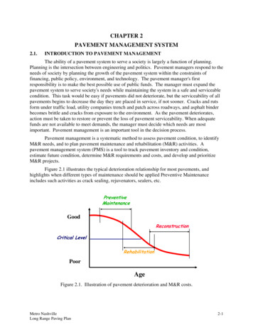
CHAPTER 2PAVEMENT MANAGEMENT SYSTEM2.1.INTRODUCTION TO PAVEMENT MANAGEMENTThe ability of a pavement system to serve a society is largely a function of planning.Planning is the intersection between engineering and politics. Pavement managers respond to theneeds of society by planning the growth of the pavement system within the constraints offinancing, public policy, environment, and technology. The pavement manager's firstresponsibility is to make the best possible use of public funds. The manager must expand thepavement system to serve society's needs while maintaining the system in a safe and serviceablecondition. This task would be easy if pavements did not deteriorate, but the serviceability of allpavements begins to decrease the day they are placed in service, if not sooner. Cracks and rutsform under traffic load, utility companies trench and patch across roadways, and asphalt binderbecomes brittle and cracks from exposure to the environment. As the pavement deteriorates,action must be taken to restore or prevent the loss of pavement serviceability. When adequatefunds are not available to meet demands, the manager must decide which needs are mostimportant. Pavement management is an important tool in the decision process.Pavement management is a systematic method to assess pavement condition, to identifyM&R needs, and to plan pavement maintenance and rehabilitation (M&R) activities. Apavement management system (PMS) is a tool to track pavement inventory and condition,estimate future condition, determine M&R requirements and costs, and develop and prioritizeM&R projects.Figure 2.1 illustrates the typical deterioration relationship for most pavements, andhighlights when different types of maintenance should be applied Preventive Maintenanceincludes such activities as crack sealing, rejuvenators, sealers, l LevelRehabilitationPoorAgeFigure 2.1. Illustration of pavement deterioration and M&R costs.Metro NashvilleLong Range Paving Plan2-1
Resurfacing is selected for badly deteriorated pavements that can no longer provideservice and must be replaced with a new pavement. Reconstruction typically entails theplacement of large patches and/or asphalt concrete overlays. Unit costs are much lower forpreventive maintenance if applied before major distress occurs as compared to rehabilitationcosts for a badly deteriorated pavement.The first step in pavement management is to determine the state of the pavement system.This is accomplished by a comprehensive inspection of all pavements in the road network. Thenetwork of pavements is first divided into logical components, such as a single street, called aroute. Each route is then divided into pieces small enough to efficiently manage, known assegments. Each segment is evaluated for surface condition and assigned a level of importance.Condition evaluation requires at minimum a visual inspection (using automated digital imaging)with independent measurement of roughness, rutting, and raveling. The level of detail of thevisual survey is selected to complement the other data collected during the evaluation process: acondition rating in accordance with ASTM D6433 Pavement Condition Index (PCI) survey with38 distress types and multiple severity levels. The importance of a segment is determined by thepavement manager, and is typically a function of street use, location, traffic type, and trafficvolume.After the condition of the pavement network has been determined, the pavement managermust select treatment options that are appropriate to address the maintenance and rehabilitation(M&R) needs of the pavement system. The selection of treatment options is based onapplicability, availability, and cost of treatments that have been proven effective in field testsalong Nashville streets. Treatments should address or prevent deficiencies in the pavementwithout causing additional problems. A treatment that requires materials or skills not readilyavailable should not be selected. The total cost of a treatment process throughout its life cycleshould be considered, because often a treatment with a low initial cost will not have the greatestcost-to-benefit ratio. Once the treatment options have been selected, the guidelines for use andapplication of each option must be established. The combination of treatment options andguidelines for selecting the appropriate option for a project are collectively known as amaintenance policy.By standardizing the available treatments and the treatment selection process, amaintenance policy allows reasonably accurate estimation of maintenance needs several yearsinto the future based on current pavement conditions. The estimated M&R needs can be used todevelop paving plans and M&R projects. Historical and bid cost data can be used to calculatethe cost of the required M&R projects, which is then compared to anticipated budget levels todetermine the most effective way to allocate funding. PMS cost data can also provide supportfor additional funding requests, and justify planned or previous expenditures.2.2.PMS SOFTWARE SELECTION PROCESSPMS software packages vary in scope, sophistication, ease-of-use, and capability, and noone package will satisfy the needs of the many different state and local PMS users. The propersoftware must be chosen, or the PMS will fall into disuse.Metro Paving Department personnel evaluated several candidate software packagesbefore selecting PMS software for use. Most of the software programs selected as candidates byMetro were listed in the Pavement Management Catalog produced by the U.S. Department ofTransportation and Federal Highway Administration Office of Asset Management. Other2-2Metro NashvilleLong Range Paving Plan
software programs evaluated were chosen based on their presence in the pavement managementindustry.The software selection approach taken by Metro was to define the major components ofPMS software and then determine the needs of Metro with respect to each component. Ratingforms and criteria were developed prior to reviewing the candidate software packages. Eachcomponent of each candidate package was then rated on a scale of 1 (low) to 10 (high) againstMetro's needs. Each software package was scored in the following 24 areas based on the criterialisted below. Segment Identification Scheme: Ease of use, flexibility, ability to fit in with othersystems.The method used to identify a particular pavement segment should be easy tounderstand. Data about the route name, roadway location from segment start tosegment end, address, and block-to-block segments should be readily accessible. Segmentation: Adequate segment descriptors, dynamic segmentation.The method used by the software to divide the pavement network into manageablesegments should be logical and easy to follow. The segmentation method shouldcomplement the segment identification scheme. Pavement Data: Supports pavement data with ease and flexibility.The program should store physical pavement inventory data from the field such asgeometrics, construction date, layer thickness, layer properties, and subgrade. Pavement Condition: Supports pavement condition data with ease and flexibility.The software should provide tools to manage and report pavement condition datasuch as distress, roughness, and rutting, and to correlate the data into pavementcondition indices for reporting the overall condition of the roadway. History: Supports pavement construction and condition history.The program should store, manage, and analyze a wide range of historical dataneeded to produce future rehabilitation and maintenance projects. Other Inventory: Ability to support other roadway assets in the PMS.The program should store, manage, and analyze other right-of-way assets (sidewalks,utilities, etc.) in conjunction with pavement data, or integrate with software formanaging other assets. Flexibility: Allows the user to make changes in screens, reports, fields, and indices.The software allows the user to customize the input, analysis, output, and presentationsystems. The more flexible a system is, the less training and the fewer changes incurrent pavement management procedures need to occur. Distress Analysis: Process used to calculate surface distress index.The software should have the ability to calculate the selected condition index fromdistress data.Metro NashvilleLong Range Paving Plan2-3
Condition Modeling Tools: Mathematical model used to predict future roadcondition.The system should allow the user to easily estimate future pavement condition basedon historical pavement condition data. Treatment Selection: The right treatment at the right place at the right time.The software should select the right preventive maintenance or rehabilitationtreatment based on the condition of the road is critical to a successful pavementmanagement system. The treatment selection system must also be easy for Metro tounderstand and change. Prioritization: Prioritize a maintenance & rehabilitation schedule.The software requires the ability to take pavement condition data of the roadwaynetwork and generate an M&R list based on other variables within the pavementmanagement system such as functional class, planned utility projects, etc. Economics: Budget analysis.The software must simulate various budget scenarios, estimating future pavementcondition of the network based on current pavement condition and various fundinglevels. Like treatment selection, the budgets in the software must be easy tounderstand and change. Reports: Software is flexible enough to generate various types of reports.The software should allow the end user to easily generate custom reports using toolssimilar to existing products (MS Access, Crystal Reports, etc.) Graphs: Software is flexible enough to generate various types of graphs.The software should have the ability to produce various types of charts and graphs.The software should allow the end user to create or modify custom graphs. GIS: Software supports a "live link" to update and view pavement data through aGIS.The software should be designed to easily work with GIS software applications. Datafrom the system can be used to automatically update GIS maps at the agency. Twoway data sharing at the database level is the preferred method of GIS interaction. Web: The ability to report data and access data through the web.The software should be designed to allow data access and reporting through a Webbased application. Interaction with other software: The ability to interact with other softwareapplications.The software should use an open data standard to allow data sharing with current andfuture Metro applications. 2-4Data: Supports the inclusion of various types of data in the system easily.Metro NashvilleLong Range Paving Plan
The software supports and manages other data elements such as images, GPS, trafficand other data issues within the pavement management system. Network: Operates on the network with ease and flexibility.The software requires capability to operate in a network environment with ease andflexibility. The software should support multiple simultaneous users. Security: Data must be safe from malicious or accidental corruption.The software requires capability to serve several users and still provide dataprotection. The software should support user-, field-, and record-level locking toallow interaction with non Paving Department employees. Ease of use: Software is easy to use.Users should be able to update and query the system with a minimum of difficulty. Ease of training: Software is easy to learn to use.New users should be able to use the software after a minimal training period. Cost: Software cost must be reasonably priced.The software cost should be competitive, and allow for per-seat and expandablelicenses.2.3.REVIEW OF CANDIDATE PMS SOFTWAREInterviews were conducted with PMS software providers to review and evaluatecandidate pavement management systems for the Metro Nashville and Davidson County LongRange Strategic Paving Plan. Many candidate systems were rejected early in the process forreasons of cost or scope. Systems with a software cost of more than 50,000 were rejected.Other packages were rejected because the vendor required the client to purchase pavementmanagement services in order to receive the (often proprietary) software. Still other packageswere rejected as insufficient for the size and scope of the Metro road network. Once all of thecandidate PMS providers were evaluated, CartêGraph’s Pavement View Plus was selected forimplementation at Nashville and Davidson County. Items such as ease of use, learning curve,and cost were key factors.2.4.CARTÊGRAPH PAVEMENTVIEW PLUSPAVEMENTview Plus is divided into two modules. The “Segments” module containsinventory data for the network, including current conditions and physical attribute data. Theother module, “Segment Analysis Models”, contains the analysis routines and informationrequired to produce a paving plan for Metro’s pavement network.Both modules allow users to create custom forms, or data access screens. For example,the default inventory form has several fields (data items, such as pavement type or street name)but can be modified to omit fields that are not needed or to add new fields. This form has beenmodified to display only the information of interest to Metro Paving and added fields to theinventory database to store total route lengths and a flag (yes or no) for routes where state fundsare used in maintenance. The network inventory forms have been modified to display the digitalMetro NashvilleLong Range Paving Plan2-5
images used in distress data collection. Multiple forms may be open at the same time in thesoftware.The entire system was linked to Metro’s Geographic Information System (GIS) usingCartêGraph’s MAPdirector for ArcGIS software. Because the data from the system is stored inthe Microsoft SQL Server database operated by Metro’s IT department, it is also possible to getinformation directly from the database for use in the GIS or other related applications. UsingSQL Server to store the PMS data also improves the integrity of the system and insures that thedata is backed up appropriately in the processes used by the IT department.The process of customizing PAVEMENTview Plus for Metro Public works consisted offour parts: Schema modification (a schema is the definition of the fields in the database and howthey are related to each other) – This process involves deciding which fields to add tothe PAVEMENTview database. Form modification – the creation of appropriate forms that make the data easy to getto and read while still showing all the required information in a minimum of space. Data modification – adding the required data to the pick lists (drop-down menus) inthe inventory and the parameters of the pavement management engine. Report modification – adding and editing the default reports provided with thesoftware to retrieve the required information from the system in a printable format.This includes creating custom charts.Each part of the process is described in more detail below.2.4.1. Schema ModificationOnly a few data fields were added to the software to accommodate the data that waseither available in the systems currently maintained by Metro or collected as a part of this effort.Most data could be accommodated by existing fields in PAVEMENTview Plus. Fields andrecord-sets had to be added to store the links to the photographs collected during the survey.There are four additional record-sets, one for each camera on the digital survey vehicle (forward,sign, rear, and downward). Each record-set contains fields for the name of the file (digitalpicture) and station recorded by the survey vehicle’s DMI. All of these record-sets were addedunder the root record-set for inventories: Segments.Several fields were also added to the Segments record-set itself:2-6 Is State Aid – a yes or no field that marks a road as eligible for state assistance whenimprovements are performed. These streets are still maintained by Metro. Thisinformation was obtained from Metro’s GIS system. Paving Group – A list of districts for each paving group was stored in the Zone field(a default PAVEMENTview field), and a new field was created to store the pavinggroup data. The new field is a text field as opposed to a numerical field to allowexpansion of the system. Sequence ID – A numeric field used to put the segments of a route in order whenviewing pictures or browsing the database.Metro NashvilleLong Range Paving Plan
A length field was also added to the Route record-set that, like Segments, is a root recordset. This length field stores the total length of all the segments on a route as provided by theGIS. This field should not be confused with the length field under the Segments record-set. Thelatter is a measurement of the length of an individual segment.2.4.2. Form ModificationsDefault forms were used whenever possible. Figure 2.2 shows the modified SegmentInformation screen from the CartêGraph PMS software. This is the most commonly used formin the PMS. Segment identification elements including route name, segment start, segment end,start address, end address, route length, and pavement length and width are found here. Alsodisplayed are the current condition and the latest survey image of the current segment. This formis also used to access other forms showing construction history, distress details, and other cameraviews.Figure 2.2. Example of pavement Segment data with forward view roadway image.Figure 2.3 shows the distress detail form, accessed from the "Detailed Distresses" buttonof the main form. This form is used to review, modify, and update distress inspection data.These distresses are then used to calculate the distress condition index, discussed in Chapter 3.A reference area, showing a typical photo and standards for identifying each distress, is includedon this form.Metro NashvilleLong Range Paving Plan2-7
Figure 2.3. Example of distress data and associated digital imagesConstruction history information is accessed from the "Events" tab of the main form, asshown in Figure 2.4. Information about M&R performed on this segment of roadway isdisplayed in place of the condition information. The road shown in the figure received a mill and1.5-inch asphalt overlay in June of 2005.Figure 2.5 shows the analysis screen, where the parameters are combined to create a workplan. When analyzed together, the combination of parameters generate a specific work plan andfuture condition assessment of the network. This is the work engine of the pavementmanagement system2-8Metro NashvilleLong Range Paving Plan
Figure 2.4. Example screen showing construction.Figure 2.5. Segment Analysis screen used to generate work plans.Metro NashvilleLong Range Paving Plan2-9
2.4.3. Data ModificationThe data modification in the inventory module consisted primarily of modifying pick lists(drop-down menus) with the choices specified by Metro. For example, the pick list for“Jurisdiction” was modified to include “Metro Nashville”, “Private”, “State Highway”, and“Unknown”. Changes were also made to the condition calculation factors, discussed in Chapter3.The pavement management analysis module customizations were, by necessity, morecomplicated since they did not involve simply storing data. Due to the complexity, Chapters 3and 4 are devoted to discussing the modifications to the pavement management analysis module.Chapter 3 discusses condition data and how the software stores and handles it. Chapter 4 is thedecision making process used by the software to generate work plans. The "Settings" formshown in Figure 2.6 is where the various parameters required to generate these work plans areconfigured.Figure 2.6. Pavement analysis settings form.The parameters that can be customized from the "Settings" form are:2-10 Activities – A list of the maintenance, rehabilitation, and
The program should store physical pavement inventory data from the field such as geometrics, construction date, layer thickness, layer properties, and subgrade. Pavement Condition: Supports pavement condition data with ease and flexibility. The software should provide tools to m