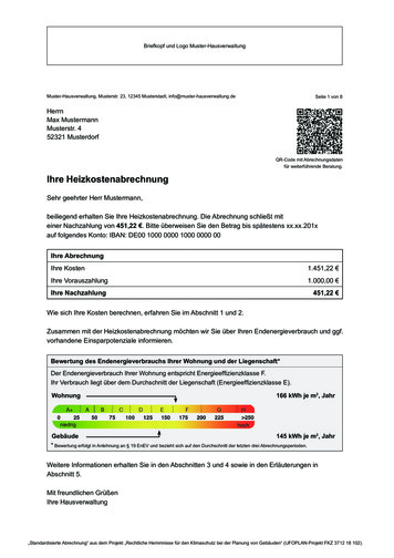
Transcription
CloudspottingguideThe Great British Weather – Cloud Spotting Guidei
WelcomeAlexander ArmstrongCarol KirkwoodChris HollinsThe Great British WeatherTeam have put together thisguide. We hope it will help youidentify those different fluffy(and not so fluffy) objectsin the sky.Even if you’ve never tried cloud spottingbefore, get started with our easy-to-usecloud manual. Once you think you knowyour Cumulus from your Cumulonimbus whynot use the cloud spotter score card whichrates the top ten clouds to spot. Can youspot all ten?There are more things to discover about theweather at bbc.co.uk/greatbritishweather,including “How to” videos on buildinga rain gauge and understanding weatherterminology.There’s also a safety guide for takingphotographs of the weather (mostlycommon sense of course), but worth a look.You can get involved with the productiontoo by sending your best snaps togreatbritishweather@bbc.co.uk and theymay be broadcast live on the BBC Oneshow, on our special BBC Weather galleriesor on a live weather forecast.And don’t forget to join in the weatherbanter @BBCbritweather and #BBCgbwfrom now till 5 August 2011.Happy cloud spotting!iiThe Great British Weather – Cloud Spotting Guide
IntroductionClouds are made of water –tiny droplets of water in thecase of the low clouds and icecrystals in the high clouds(mid-level clouds often containa mixture of the two).There are ten basic types of cloud and theyare grouped according to the way they look– whether they’re made up of individualclumps, or layers or streaks – and how highthey are – whether low, mid-level or highclouds. The ten types are divided up intomany other species and varieties.This guide contains just a few of the manydifferent cloud types – some common andeasy to spot, some rare. You never knowwhen an interesting formation is going toappear, so always keep an eye on what ishappening above.bbc.co.uk/greatbritishweatherThe Great British Weather – Cloud Spotting Guide1
1. CumulusCumulusCumulus – InvernessWhat to look forCumulus clouds are the cotton wool puffs, withflat bases and cauliflower tops, which drift lazilyacross the sky on a sunny day. They generallyform a few hours after daybreak and tend toscatter before sundown. They form on invisiblecolumns of air (known as thermals) which risefrom the ground as it is warmed by the Sun.Most forms of Cumulus produce no rain or snow,and so are known as fair-weather clouds. Whena Cumulus is fraying at the edges as it breaksup, having reached the ripe old age of 15minutes or so, it is known as Cumulus fractus.What they mean for usThe smaller Cumulus humilis never produceany rain or snow, but large Cumulus cloudscan produce light to moderate showers.When Cumulus build upwards through themorning they’re a warning of heavy showersby the afternoon: ‘in the morning mountains,in the afternoon fountains’.Cumulus humilisKey factsIf you were to addtogether all thedroplets in a mediumsized Cumulus cloud,they’d weigh the sameas 80 elephants.60Cloud points(because they are easyto recognise)2The Great British Weather – Cloud Spotting Guide
2. StratocumulusStratocumulus – CulbinWhat to look forThe most widespread of all cloud types in theUK, as well as many other regions of the world,Stratocumulus is a low layer or patch of cloudthat has a clumpy base. The patches are eitherjoined up, or have gaps in between. When thesky is overcast with a cloud base that appearsto be low and the tones of the cloud vary fromwhite to darker grey, you can be confident thatyou are looking at a Stratocumulus.What they mean for usStratocumulus clouds do sometimes producerain or snow, but this is generally quite light.Their main effect is of blocking out our belovedsunshine. Often in the UK, Cumulus clouds canbecome more and more plentiful through themorning, spreading out and joining togetherinto a Stratocumulus layer that covers the sky.StratocumulusKey factsSometimes youcan see fingers ofsunlight shining downthrough breaks in aStratocumulus cloud.These are known as‘crepuscular rays’.30Cloud points(because they areso common)“ My favourite cloud is the cumulus as it normallymeans we can expect fair weather. Those whitepuffy clouds in a blue sky on a summer’s day area view hard to beat.”Carol KirkwoodThe Great British Weather – Cloud Spotting Guide3
3. CumulonimbusCumulonimbusCumulonimbusWhat to look forOften described as the King of Clouds, theCumulonimbus is an awesome powerhouse ofthe atmosphere. This enormous storm cloud canreach over 10 miles into the sky, often spreadingout in its upper reaches to form a huge canopyof ice crystals that can give it the appearance ofa blacksmith’s anvil.The anvil shape can only be seen when viewedfrom many miles away. Above you, it looks likea very dark, often ragged cloud base whichextends across most of the sky.What they mean for usCumulonimbus are the storm clouds. Theyproduce heavy rain, snow or hailstones, aswell as sometimes leading to thunder andlightning. Unlike the other main rain-bearingcloud, the dark, featureless ‘wet blanket’called Nimbostratus that produces prolongedand continuous rain, Cumulonimbus deliversits load in dramatic, sudden downpours.Key factsAircraft pilots arecareful to avoid flyingthrough thesemonsters because thepowerful up and downdraughts within themcan be strong enoughto flip a plane over.100Cloud points(especially if you see itsanvil shape from afar)“ I flew through clouds on a hang glider for the series.It was terrifying and exhilarating. The sky was soblue and the clouds a brilliant white. You simplydon’t appreciate the enormous size, and inherentmagnitude of a cloud from the ground.”Carol Kirkwood4The Great British Weather – Cloud Spotting Guide
4. AltocumulusAltocumulusAltocumulusWhat to look forThis mid-level cloud is in the form of layers orpatches of individual clumps or rolls of cloud,known as ‘cloudlets’. If you see a layer of cloudthat looks like it is made of lots of regularcotton-wool balls, it might be an Altocumulus.A similar looking cloud, though one that is rarer,is the higher Cirrocumulus. This is also a layer orpatch composed of little cloudlets but theyappear much smaller than the Altocumulusones. To distinguish between the two, you needto hold a finger up at arm’s length towards thecloud directly above you. If the cloudlets aresmaller than the width of your finger, the cloudis Cirrocumulus; if they are wider, it is probablyAltocumulus.What they mean for usThe rain and snow from Altocumulus maynot tend to reach ground level but, to thekeen cloud spotter, these clouds can be earlyindicators of storms ahead. If the cloudletshave very bumpy tops they suggest that thatatmosphere at that level is unstable. This meansthat any Cumulus clouds building up frombelow are likely to grow into Cumulonimbusstorm clouds that will bring heavy showersin the afternoon.The Great British Weather – Cloud Spotting GuideCirrocumulusKey factsAltocumulus cloudssometimes produce rainor snow but it rarelyreaches the ground,usually drying up as itfalls. This creates trailsbelow them which makethe cloudlets looklike jellyfish.70Cloud points(especially if they are arrangedin a beautiful organised layer,like a quilted blanket)5
5. The Layer CloudsAltostratusStratusWhat to look forGenerally speaking, layer clouds are the mostboring looking of all the cloud types. With novariation in tone from one part to the next, theyare just a flat, overcast sky.Layer clouds form at all three cloud levels.The low ones are called Stratus, and can beright down at ground level, when they areknown as fog or mist. They often block the Suncompletely. Mid-level layer clouds are calledAltostratus, and often make the Sun appear asif through frosted glass. The high layer cloudsare called Cirrostratus, which are made of icecrystals rather than droplets.What they mean for usAltostratus can produce light to moderaterain or snow, but the fourth layer cloud thatproduces most precipitation is the Nimbostratus.This thick blanket of cloud often extendsthrough all three levels and rains and rains.6Key factsStratus clouds havebases at anywherefrom the ground to1,500ft. Altostratus areat 6,500-16,500ft.Cirrostratus have basesat 16,500-30,000ft,while Nimbostratus canbe over 10,000ft deep.45Cloud pointsThe Great British Weather – Cloud Spotting Guide
6. CirrusCirrus – Hampstead HeathWhat to look forThe most beautiful of the main cloud types,Cirrus clouds are like watercolour brush strokesacross the blue. Composed of ice crystalscascading through the high atmosphere theyare generally see-through. As the ice crystalsfall downwards through different regions of theatmosphere, they pass through faster andslower winds and drier and moister air, whichgive the cloud its distinctive wavy strokes,known as ‘fallstreaks’.What they mean for usThe falling ice crystals of Cirrus clouds neverreach the ground, tending instead to evaporateon the way down. If they are seen to jointogether and thicken into the high layer cloudCirrostratus, they can be an early indication ofa change in the weather that will lead to steadyrain. Other than that, they just look nice.“ Being up in the clouds was awesome.I couldn’t taste anything – fear probablyplayed a part in that – but thinking aboutit now, the smell was probably similar towhen you open up the door of your deepfreeze and you get that ‘cold/icy’ smell.”Carol KirkwoodThe Great British Weather – Cloud Spotting GuideCirrusCirrus – BristolKey factsCirrus clouds arenamed after the Latinfor a lock of hair.60Cloud points7
7. ContrailsContrailsContrailsWhat to look forShort for ‘condensation trails’, these are thelines of cloud that can sometimes form behindaircraft up at cruising height. Formed from thewater vapour (water in gas form) that is part ofthe aircraft exhaust, these straight, crisp lines ofcondensation could hardly look more differentfrom the wild, chaotic forms of the naturalclouds. They only appear when the air up atcruising height is cold enough and moistenough. At other times, no cloud appearsbehind the plane.What they mean for usContrails are the most visible signs of humaneffect on our atmosphere – sharp lines ofprogress, dividing and dissecting the sky –man’s marks on what, for many of us, is the lastwilderness to gaze out at.8Key factsOur atmosphere oftenconsists of differinglayers of air so it is notuncommon to see thecontrails behind anaircraft appear to turnon and off as it climbsor descends.60Cloud points(because they are socommon these days)The Great British Weather – Cloud Spotting Guide
8. LenticularisLenticularisLenticularisWhat to look forNamed after the Latin word for a lentil, theseare discs of cloud with smooth, streamlinededges. They often look rather like UFOs.Lenticularis clouds form in stable conditionswhen moist winds have to rise to pass overraised ground such as a hill or mountain peak.While lenticularis clouds are most often seenin hilly or mountainous regions, they can appeardownwind of even gentle, rolling hills whenthe conditions are right. The water dropletsof lenticularis clouds form at one end of thecloud and rush through it with the wind, onlyto disappear again at the back of the cloud.Though the droplets are moving, the cloudas a whole appears stationary in the steadywind at cloud level.What they mean for usOnly very occasionally do lenticularisclouds produce any rain or snow thatreaches the ground.LenticularisKey factsSometimes known as‘lennies’ for short,these clouds can format any of the threecloud levels but themost dramatic andimpressive ones arefound in the mid-levelclouds, and are knownas Altocumuluslenticularis.125Cloud pointsThe Great British Weather – Cloud Spotting Guide9
9. MammaMammatus – Waterloo BridgeMammatusWhat to look forAlso known as mammatus, these are pouchesthat hang down from the underside of a cloudlayer. They are easiest to spot when the Sun islow, and is shining across the base of the cloudlayer, picking out the udder-like formations (thename Mamma comes from the Latin for udders).They can be spotted hanging from the base ofclouds at all three of the cloud levels. Mammaclouds are fairly rare so you have to keep an eyeout for them.What they mean for usMamma clouds tend to appear attached to therear of the advancing storm and so they usuallyindicate that the heavy showers are falling somedistance away, or that the storm has alreadypassed over.Key factsMamma are definedas ‘supplementaryfeatures’. The mostdramatic-looking onesform on the undersideof the huge anvils thatspread out at the topof Cumulonimbusstorm clouds.150Cloud points“ You can carry on spotting when you’re abroad– I saw mammatus in the USA. It’s shaped likecows’ udders and had the setting sunlightbehind it. It looks heavy (it’s descending air)almost like it is going to fall on top of you!”Carol Kirkwood10The Great British Weather – Cloud Spotting Guide
10. NoctilucentNoctilucentWhat to look forNoctilucent clouds form so high up in theatmosphere – often around 50 miles up –that they are way higher than the 10–12 milesor so in which our normal weather clouds form.These strange clouds have an eerie, bluish-whiteappearance, and often exhibit delicate ripplesor billows that can extend across huge areas ofthe sky. Their name means night shining. Beingso high, they still catch the sunlight when therest of the sky is dark.These clouds are rare, and only form in thesummer – typically between the end of May andmid-August. Look for them when the sky is clearof lower clouds and within a few hours of sunsetor sunrise.NoctilucentKey factsThe shifting patternsin the formation ofthese mysteriousclouds are increasinglyconsidered valuableindicators of ourchanging climate.300Cloud pointsWhat they mean for usNoctilucent clouds are far, far too high tohave any direct effect on weather down onthe ground.“ Before you head out to take some pictures ofclouds, make sure your camera is fully charged.I have come unstuck with this one in the past! If youhave one, stick a spare battery in your pocket too.”Carol KirkwoodThe Great British Weather – Cloud Spotting Guide11
Get spotting!Use our handy score card tosee how many of the clouds inour guide you can spot over thecoming weeks and see if you canreach our grand total of 1,000.1. CumulusDon’t forget Carol’s helpful tipsabout remembering to do somecloud spotting when you’reon holiday.Happy cloud spotting from theGreat British Weather team.2. StratocumulusAltitude: Low: 1-5k ftAltitude: Low: 1-4.5k ftRainfall:Rainfall:Rarity score:Date spotted:60XCloud score:Rarity score:Date spotted:4. AltocumulusAltitude: Multi-level: 2-45k ftAltitude: Mid-level: 6.5-20k ftRainfall:Rainfall:Date spotted:Cloud score:12XCloud score:3. CumulonimbusRarity score:30100XRarity score:70Date spotted:XCloud score:The Great British Weather – Cloud Spotting Guide
5. The Layer Clouds6. CirrusAltitude: All 3 layersAltitude: High: 20-40k ftRainfall:Rainfall:Rarity score:45Rarity score:Date spotted:XDate spotted:Cloud score:8. LenticularisAltitude: High: 20-40k ftAltitude: Low: 1-5k ftRainfall:Rainfall:Date spotted:60XRarity score:Date spotted:9. MammaX10. NoctilucentAltitude: All 3 layersAltitude: V.V. high: 30-50 milesRainfall:Rainfall:Date spotted:125Cloud score:Cloud score:Rarity score:XCloud score:7. ContrailsRarity score:60150XCloud score:Rarity score:Date spotted:300XCloud score:Grand totalThe Great British Weather – Cloud Spotting Guide13
terGavin Pretor-Pinney, author ofThe Cloud Collector’s Handbook andfounder of The Cloud Appreciation Society.PhotographyPage 3/12: Stratocumulus – Heather ReidPage 10/12: Mamma – Shevaun MendelsohnDesignred-stone.comOur thanks to BBC Weather and members of thepublic for photographs contributed. Thanks alsoto Carol Kirkwood and the Met Office. BBC Learning 2011
The Great British Weather – Cloud Spotting Guide 3 2. Stratocumulus What to look for The most widespread of all cloud types in the UK, as well as many other regions of the world, Stratocumulus is a low layer or patch of cloud that has a clumpy base. The patche