Transcription
Technical Assistance Consultant’s ReportFinal ReportProject Number: 40255-01March 2011Socialist Republic of Viet Nam: Central Mekong DeltaRegion Connectivity(Financed by the Japan Special Fund)Prepared by SMEC International Pty Ltd in association with Nippon EngineeringConsultants Co Ltd, and Thanh Cong Transport Engineering ConsultingCompanyThis consultant’s report does not necessarily reflect the views of ADB or the Government concerned, andADB and the Government cannot be held liable for its contents. All the views expressed herein may notbe incorporated into the proposed project’s design.
ADB TA 7045-VIE: Preparing theCentral Mekong Delta Region Connectivity ProjectSMEC International Pty Ltdin association withNippon Engineering Consultants Co LtdandThanh Cong Transport Engineering Consulting CompanyProject Preparation Technical AssistanceSummary Project Proposal ReportJanuary 2011
For:ADB PPTA 7045-VIE:Preparing the Central Mekong Delta Region Connectivity ProjectSummary Project Proposal ReportJanuary 2011
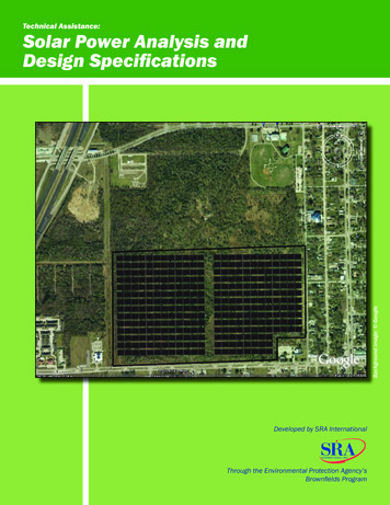
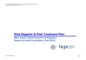
TABLE OF CONTENTS1The Proposal . 12The Project . 3345672.1Rationale . 32.2Impact and Outcome . 42.3Outputs. 42.4Investment and Financing Plans . 4Project Implementation . 63.1Staged Implementation . 63.2Co-financing of Stage 1 . 63.3Components Financed by Korea. 63.4Components Financed by ADB. 6Procurement Plan . 74.1Contract Packages. 74.2Procurement of Civil Works . 84.3Standard Bidding Documents . 84.4Procurement Schedules . 94.5Recruitment of Consultants . 9Implementation Arrangements . 115.1Executing Agency and Implementing Agencies . 115.2Consultants. 135.3Construction Supervision Consultant – Korean Component . 135.4HIV/AIDS and Human Trafficking Prevention Plans . 135.5Independent Monitoring Agencies. 13Due Diligence. 146.1Technical . 146.2Access Surveys . 166.3Economic. 196.4Operations and Maintenance. 206.5Time and Vehicle Operating Costs. 206.6Capacity and Traffic Forecasting . 216.7Sensitivity Analysis . 246.8Financial . 256.9Poverty and Social . 276.10Resettlement Plan. 296.11Environmental Impact Assessment . 36Recommendation . 41LIST OF LINKED DOCUMENTS. 42Preparing the Central Mekong Delta Region Connectivity Project Summary Project Proposal Report January 2011Page i
LIST OF TABLESTable 2.1: Project Investment and Financing Plan ( millions) . 4Table 2.2: Tentative Financing Plan . 5Table 4.1: Stage 1 Contract Packages . 7Table 4.2: Major Milestones – ADB Financed Components . 9Table 4.3: Tentative Project Implementation Schedule – KEXIM Financed Components .10Table 6.1: Groups Consulted - Access Surveys November 2010 .17Table 6.2: Key Recommendations from Access Surveys .17Table 6.3: Financial Costs, USD millions (mid-2010) .19Table 6.4: Required Ferry Service Growth.20Table 6.5: Passage Time .20Table 6.6: Capacity and Speed Relationship .22Table 6.7: Forecast Traffic, Vehicle/Day .23Table 6.8: Economic Analysis, Components 1, 2 and 3, USD millions .24Table 6.9: Resettlement Budget Estimate Component 1 .30Table 6.10: Resettlement Budget Estimate Component 2 .32Table 6.11: Resettlement Budget Estimate Component 3 .34LIST OF FIGURESFigure 1: Connectivity Project Dong Thap Province and Can Tho City (Province) .2Figure 2: Project Implementation Arrangements .12Figure 3: Bridge Cross Section .14Figure 4 Road Cross-Section Proposed for Road with Design Speed 80km/H .14Figure 5: Can Tho Province approach to the Vam Cong Bridge showing the comparable profiles .15Figure 6: The Vam Cong approach bridge in Dong Thap Province, left bank of the river Hau showing thecomparable profiles for different longitudinal gradients 2.5% and 4 % .15Preparing the Central Mekong Delta Region Connectivity Project Summary Project Proposal Report January 2011Page ii
CURRENCY EQUIVALENTSCurrency UnitUSD 1.00– Dong (VND)VND 19,000Viet NamABBREVIATIONSAADTADB––Average Annual Daily TrafficAsian Development BankCOIDP––Corridor of ImpactDisplaced PersonDRVNEDCF––Directorate for Roads of Viet Nam (formerly VRA)Economic Development Cooperation Fund (Korea)GMSEMP––Greater Mekong SubregionEnvironmental Management PlanEMOPGOVNGVW–––Environmental Monitoring PlanGovernment of Viet NamGross Vehicle WeightHATPP–HIV/AIDS and Human Trafficking Prevention PlanMOT–Ministry of Transport (Viet Nam)NHp.a.PDOT–––National Highwayper annumProvincial Department of Transport (Viet Nam)PMU-MTPRQLROW––––Project Management Unit – My ThuanProvincial RoadQuoc Lo (National Highway Viet Nam)Right of WayTLVDRVEC–––Tinh Lo (Provincial Road Viet Nam)Viet Nam Directorate of RoadsViet Nam Expressway CorporationVRA–Viet Nam Road AdministrationWEIGHTS AND S(i)The fiscal year (FY) of the Government of Viet Nam ends on 31 December. FY before a calendaryear denotes the year in which the fiscal year ends, e.g., FY2011 ends on 31 December 2011(ii)In this report, " " refers to US dollarsPreparing the Central Mekong Delta Region Connectivity Project Summary Project Proposal Report January 2011Page iii
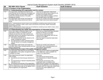
Source: ADBPreparing the Central Mekong Delta Region Connectivity Project Summary Project Proposal Report January 2011Page iv
1 The Proposal1.Vietnam is currently experiencing rapid economic growth, based primarily on export processingindustries and tourism. Between 2003 and 2009 gross domestic product (GDP) grew by an average of 8%per year, while exports in the same period grew by an average of about 20%. The Mekong Delta region,where the proposed Project is located, is the third-largest industrial centre in the country after Ho Chi MinhCity (HCMC) and Hanoi, and is based primarily on agro-industry and other light industries. Industrialproduction in the Mekong Delta region has accelerated in recent years, from an average annual growth rate of13% in the period 2000–2004 to a growth rate of 24% in 2004–2005, and 25% to 2010.2.As a result of this economic growth, road traffic is also growing rapidly and is a key constraint to futuredevelopment. Between 2000 and 2009, for example, passenger traffic grew at an average rate of about 11%per year and freight traffic at an average rate of about 12%. The Government of Viet Nam is upgrading andexpanding Vietnam’s strategic transport infrastructure – including the road network.3.The ultimate project will improve connectivity in the Mekong Delta Region and provide efficient accessfrom Ho Chi Minh City to the Southern Coastal Region through construction of high cable-stayed bridgesacross the Mekong River and associated roads:(i)(ii)(iii)(iv)(v)(vi)4.Component 1 – Cao Lanh Bridge (2.1km) and approach roads (5.7km);Component 2 – Interconnecting Road (15.7km);Component 3 – Vam Cong Bridge (2.9 km) and approach roads (2.9km);Component 4 – Long Xuyen Bypass (17.5km);Component 5 – Long Xuyen Bypass extension (5.7km);Component 6 – My An – Cao Lanh connecting road (26.9km).The Project comprises the following components as shown on the map in Figure 1 below:(i)(ii)(iii)Component 1 – Cao Lanh Bridge (2.1km) and approach roads (5.7km);Component 2 – Interconnecting Road (15.7km);Component 3 – Vam Cong Bridge (2.9km) and approach roads (2.9km).5.The Project sits in the boundaries of Dong Thap, An Giang and Can Tho Provinces. The bridges willbe constructed to four-lane carriageway and two-lane motorcycle lane standard with total bridge width of 24.5meters and the interconnecting road will be constructed initially to four-lane standard with formation width of20.6 meters to be widened to six-lane standard in future.6.The Project calls for the construction of two high bridges and a series of smaller ones with a combinedlength of about 9,469 meters (m) to cross the channels along with the construction of about 20 kilometres(km) of access roads including an interconnector road between the two bridge sites. In addition, the conceptis to construct toll plazas to collect bridge tolls, similar to the My Thuan Bridge on National Highway IA. TheGovernment of Viet Nam intends to collect road tolls at the proposed new major bridge crossings to help withthe construction and maintenance of the bridges.Preparing the Central Mekong Delta Region Connectivity Project Summary Project Proposal Report January 2011Page 1
Figure 1: Connectivity Project Dong Thap Province and Can Tho City (Province)Preparing the Central Mekong Delta Region Connectivity Project Summary Project Proposal Report January 2011Page 2
2 The Project2.1 Rationale7.Viet Nam’s economy grew rapidly in recent years, based primarily on export processing industries andtourism. The Mekong Delta Region (the Delta) is the third-largest industrial centre in the country after Ho ChiMinh City (HCMC) and Hanoi, and its economy relies mainly on agro-industry and other light industries. TheDelta is also known as the “rice-basket” of the country and contributes significantly to Viet Nam’s record riceexports making it a top three world’s rice exporter.1 However, poverty remains high and the Delta is oftenprone to natural disasters. Rapidly growing traffic volumes and poor infrastructure remain key constraints toeconomic growth and development.8.The transport network in the Delta is in its early stages of development and is constrained by aninsufficient road network, extensive but slow inland waterways 2 and fast growing road traffic volumes amidstrong economic growth in recent years. A growing demand for an efficient transport network prompted theGovernment to set targets in its proposed 5-year Transport Development Plan 2011-2015 3 to transport 796million tons or 64.2 billion ton-kilometre of goods, 3.15 billion passengers or 106.6 billion passenger-kilometreper year by roads alone. To achieve this, the 5-year plan aims to build, improve and upgrade about 3,000kilometres (km) of roads and 44,600 meters (m) of road bridges. The National Highway 1A (NH1A), whichruns along Viet Nam from north to south, located to the east of the Delta, is currently the only artery that givesuninterrupted road access to the Southern Coastal Region. Reliance on a single artery will not enablebalanced development of a reliable primary road network for the Delta that can facilitate efficient land usesupported by integrated development of secondary road and other infrastructure. This also constrainsbroader economic development.9.The Government embarked on the Expressways Development Plan 4 which identifies the SecondSouthern Highway (SSH) as a key road network artery for the development of the Delta. The SSH connectsHCMC through the central Mekong Delta Region to the Southern Coastal Region and serves as an alternativeto NH1A thus providing access to the south-western provinces. It also links to the Greater Mekong Subregion(GMS) Southern Coastal Corridor at Rach Gia. The SSH is currently interrupted by ferry crossings at CaoLanh and Vam Cong which are slow and of limited capacity.10. The proposed Project will remove these bottlenecks by completing the missing infrastructure foruninterrupted road access across the Mekong River Delta along the SSH artery. It will construct (i) two highcable-stayed bridges with a combined length of about 5,000 meters to cross the two branches which form theMekong River 5 (ii) about 25 km of access roads and interconnector roads between the two bridge sites, and(iii) toll plazas. The Project is expected to bring inclusive development for areas that are presently not wellconnected to major population centres, improve access to basic social and health services, improve globaland national food security by stimulating local agro-industry and boosting exports further, provide support forprivate sector investment, and extend a better regional connectivity to neighbouring Cambodia and theGreater Mekong Subregion, as well as the country’s major inland ports in the Delta. It is expected that theProject will directly benefit an estimated 170,000 road users daily 5 years after Project completion and willhelp lift living standards in An Giang, Dong Thap and Can Tho provinces, with a total population of 5 millionpeople.Mekong Delta produces about half of rice consumed in Vietnam and 80% of rice export, 40% of seafood and 50–60%of its seafood export.2 Constitutes of two main arms of Mekong River and interlocking network of canals and rivers.3 It is expected to be approved by the Government as part of the 5-year Development Plan of Viet Nam in early 2011.4 Decision 1734/QD-TTg Approval of Viet Nam’s Expressways Development Plan up to 2020 and beyond.5 The Mekong River is an international waterway under international treaty. The treaty specifies that the free headwayfor passing vessels must be at least 37m over the high water level.1Preparing the Central Mekong Delta Region Connectivity Project Summary Project Proposal Report January 2011Page 3
11. ADB’s strategy for Viet Nam 6 focuses on helping the Government reduce poverty incidence to 10-11%by 2010. In the transport sector, ADB helps the Government improve the transport investment program andsector efficiency and reduce transport costs. The Project is firmly supported by the Government and includedin its 5 year plan, as well as ADB’s Country Operations Business Plan 2009-2011 for Viet Nam. 712. The Government intends to collect tolls once the Project is completed to ensure that appropriateresources are available for operation and maintenance of the Project roads and bridges.2.2 Impact and Outcome13. The expected impact of the Project will be improved road travel across and within the Central MekongDelta interconnecting HCMC to the Southern Coastal Region and the GMS Southern Coastal Corridor. Theexpected outcome will be decreased road travel distances and increased average travel speeds across andwithin the Central Mekong Delta. The Design Monitoring Framework (DMF) is in Annex 2.2.3 Outputs14. The proposed Project is expected to (i) build two cable-stayed bridges with a combined length of about5,000m and associated [expressway standard] access and interconnecting roads with a total length of about25km, and (ii) build sufficient capacit
from Ho Chi Minh City to the Southern Coastal Region through construction of high cable-stayed bridges across the Mekong River and associated roads: (i) Component 1 – Cao Lanh Bridge (2.1 km) and approach roads (5.