Transcription
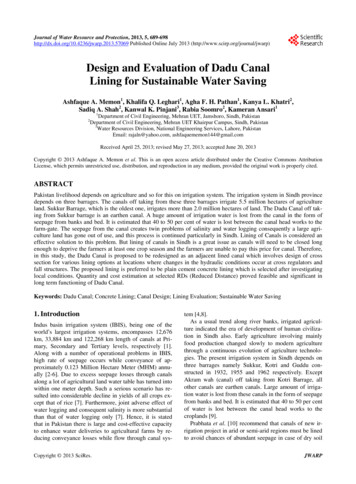
Journal of Water Resource and Protection, 2013, 5, 689-698http://dx.doi.org/10.4236/jwarp.2013.57069 Published Online July 2013 (http://www.scirp.org/journal/jwarp)Design and Evaluation of Dadu CanalLining for Sustainable Water SavingAshfaque A. Memon1, Khalifa Q. Leghari1, Agha F. H. Pathan1, Kanya L. Khatri2,Sadiq A. Shah2, Kanwal K. Pinjani3, Rabia Soomro2, Kameran Ansari11Department of Civil Engineering, Mehran UET, Jamshoro, Sindh, PakistanDepartment of Civil Engineering, Mehran UET Khairpur Campus, Sindh, Pakistan3Water Resources Division, National Engineering Services, Lahore, PakistanEmail: rajaln@yahoo.com, ashfaquememon144@gmail.com2Received April 25, 2013; revised May 27, 2013; accepted June 20, 2013Copyright 2013 Ashfaque A. Memon et al. This is an open access article distributed under the Creative Commons AttributionLicense, which permits unrestricted use, distribution, and reproduction in any medium, provided the original work is properly cited.ABSTRACTPakistan livelihood depends on agriculture and so for this on irrigation system. The irrigation system in Sindh provincedepends on three barrages. The canals off taking from these three barrages irrigate 5.5 million hectares of agricultureland. Sukkur Barrage, which is the oldest one, irrigates more than 2.0 million hectares of land. The Dadu Canal off taking from Sukkur barrage is an earthen canal. A huge amount of irrigation water is lost from the canal in the form ofseepage from banks and bed. It is estimated that 40 to 50 per cent of water is lost between the canal head works to thefarm-gate. The seepage from the canal creates twin problems of salinity and water logging consequently a large agriculture land has gone out of use, and this process is continued particularly in Sindh. Lining of Canals is considered aneffective solution to this problem. But lining of canals in Sindh is a great issue as canals will need to be closed longenough to deprive the farmers at least one crop season and the farmers are unable to pay this price for canal. Therefore,in this study, the Dadu Canal is proposed to be redesigned as an adjacent lined canal which involves design of crosssection for various lining options at locations where changes in the hydraulic conditions occur at cross regulators andfall structures. The proposed lining is preferred to be plain cement concrete lining which is selected after investigatinglocal conditions. Quantity and cost estimation at selected RDs (Reduced Distance) proved feasible and significant inlong term functioning of Dadu Canal.Keywords: Dadu Canal; Concrete Lining; Canal Design; Lining Evaluation; Sustainable Water Saving1. IntroductionIndus basin irrigation system (IBIS), being one of theworld’s largest irrigation systems, encompasses 12,676km, 33,884 km and 122,268 km length of canals at Primary, Secondary and Tertiary levels, respectively [1].Along with a number of operational problems in IBIS,high rate of seepage occurs while conveyance of approximately 0.123 Million Hectare Meter (MHM) annually [2-6]. Due to excess seepage losses through canalsalong a lot of agricultural land water table has turned intowithin one meter depth. Such a serious scenario has resulted into considerable decline in yields of all crops except that of rice [7]. Furthermore, joint adverse effect ofwater logging and consequent salinity is more substantialthan that of water logging only [7]. Hence, it is statedthat in Pakistan there is large and cost-effective capacityto enhance water deliveries to agricultural farms by reducing conveyance losses while flow through canal sysCopyright 2013 SciRes.tem [4,8].As a usual trend along river banks, irrigated agriculture indicated the era of development of human civilization in Sindh also. Early agriculture involving mainlyfood production changed slowly to modern agriculturethrough a continuous evolution of agriculture technologies. The present irrigation system in Sindh depends onthree barrages namely Sukkur, Kotri and Guddu constructed in 1932, 1955 and 1962 respectively. ExceptAkram wah (canal) off taking from Kotri Barrage, allother canals are earthen canals. Large amount of irrigation water is lost from these canals in the form of seepagefrom banks and bed. It is estimated that 40 to 50 per centof water is lost between the canal head works to thecroplands [9].Prabhata et al. [10] recommend that canals of new irrigation project in arid or semi-arid regions must be linedto avoid chances of abundant seepage in case of dry soilJWARP
690A. A. MEMONand deep groundwater table. Lining of canals is shown agood solution to this problem worldwide. Lining of canals in Sindh is a great matter as canals will need to beclosed long enough to and farmers may lose enough cropproduction which is imperative for their livelihood andnobody is ready to give them subsidy of this loss. Theirrigation application rates within the farms are also highbecause of reliance on the conventional flood irrigation.With the passage of time, water as a commodity is becoming more and more precious. Above all it is a finitesource. This high percentage of wastage, therefore, cannot be afforded for long time. Wastage of water throughpoor infrastructure or poor water management constitutesa major issue related to the water resources of Pakistan.Another aspect of this issue is the productivity of thefarms against per cusec of irrigation water. Pakistan has amuch lower rate of production. The irrigation efficiency,therefore, needs to be enhanced. In view of the huge(around 45 to 50 per cent) losses of irrigation water between canal-heads and the farm gate, water conservationshould be accorded a high priority. Lining of Canals andwater courses should be taken in hand more vigorously.2. Dadu Canal2.1. Water AvailabilityDadu canal has been designed for a normal discharge of89.2 cumec at the head. Main crops are cotton, sugarcane,wheat, rice, fruits and vegetables. Water availability ofthe Dadu Canal is highly variable due to stochastic natureof flow. Average annual availability on the basis of 5year canal diversion at the canal head and at farm gate is0.174 MHM and 0.092 MHM respectively, which showsa significant water loss of 0.082 MHM [11].2.2. Crop Water RequirementsThe net crop water requirements of 0.4, 0.85, 1.8, 2.0 and0.5 m were used for wheat, cotton, rice, sugarcane andfodder crops respectively [9]. These five major cropscover more than 80% of the total cropped area of thecanal and consume 81% of total water needed for totalcrop consumptive requirement of the cropped area. Thisincludes: wheat (12.8% of total), cotton (15.9% of total),rice (28.3% of total), sugarcane (15% of the total) and fodder (6.8% of the total). Total water requirements for Kharif crops and Rabi crops are 176 HM (Hectare·Meter) [9].2.3. AlignmentTotal length of Dadu Canal is 212 km. The alignment ofDadu Canal has a regime section. It originates from theSukkur barrage, along right bank of river Indus, passesthrough the districts of Sukkur, Larkana and Dadu running parallel to the Indus highway N55. Main cities/Copyright 2013 SciRes.ET AL.towns near the canal are Bagarji, Madeji, Naudero, Larkana, Dokri, Badah village, Mehar, Radhan village, Sitaroad village and Dadu. The canal is accessible throughthe district road bridges (DRBs) and village road bridges(VRBs) from most of the above mentioned towns. Moreover, there are many hydraulic structures and roadbridges on canal which provide interconnectivity to boththe embankments of the canal. However at some placesthere can be constraints for passage of larger vehicles.Topography of the canal sites is characterized by flatlands, waterlogged in most of the reaches. Basic parameters are given in Table 1.3. Lining and RemodelingAccording to Streeter [12] the prime parameters of hydraulic efficiency, practicability, and economy should beconsidered while using uniform flow formula to design alined canal. The lining of an existing canal invariablyinvolves remodeling of the section. The reasons are tomaintain flow levels and command due to difference inManning’s coefficient between unlined and lined materialto improve deteriorated canal sections before proceedingwith lining and to provide a firm sub-base for applicationof lining.Different lining materials are listed by Sharma andChawla [13]. Amongst various conventional types of lining Cement concrete lining are considered as most suitable because of its long life, durability, structural stability,resistance to erosion, high permissible velocity, etc. Besides the high construction cost of Cement concrete lining, there occurs some seepage due to expansion/contraction of joints. Cement concrete lining, the most commonly used type of lining, consists a layer of cement concrete placed on a well prepared and compacted sub-base.The recommended thickness of lining as per IS: 387319192 is given in Table 2.4. Design MethodologyThe design methodology involves design of cross sectionTable 1. Basic parameters of Dadu ngth (km)2123Gross Command Area (hectares)222.9674CCA (Hectares)201.8105Design Discharge (cumec)89.26Actual Discharge (cumec)1248No. of Channels1129No. of Outlets2145Source: operation and maintenance manual, ipd, government of Sindh.JWARP
A. A. MEMONET AL.6914.1. Design DischargeTable 2. Thickness of cement concrete lining.Canal discharge(cumec)Water depth(m)Lining thickness(cm)Up to 5.0Up to 9.64.56.610.212299.6699.46.69.11215.2at the locations where changes in the hydraulic conditions occur, e.g. at cross regulators/fall structures.Dadu Canal was originally designed in 1932 for a discharge of 89.2 cumec (Table 3). Over the years, theflows have been increased to 124 cumec and the estimated data show that the design discharges were proposed up to 152 cumec (Table 4).To fix appropriate value of discharge in Dadu canal,data were collected from following two sources:1) Sindh water Resources Development and Management Investment Program-Program Report, “Irrigation”.2) Prepared Design Statement of Dadu Main Canal(Table 5).To avoid discrepancies in these data cumulative dis-Table 3. Design statement of selected reaches of Dadu canal (Design Data, 1932).S. NoName of Regulator1212th km X.RName of ChannelMRDDischarge (cumec) Bed Width B 830.6613.871.980.700.57Bhambha Distry1002.44.93Daim Branch1002.411.04Bilawal pur Distry1002.41.95Dubi Minor952.50.47Lower Form Minor937.30.80Dircet Outlets (D.Os)Mean Velocity V(m/sec)5.491002.4u/s(Tail Regulator)Depth D (m)0.8220.10d/s198th km X.R932.4u/s2Phaka Distry932.45.65Upper Form Minor932.41.35Jahir Minor932.42.62Lower Noor Wah Minor883.91.41Direct Outlets (D.Os)1.1412.17d/s3175th km X.R829.9u/sUpper Noor Wah Minor829.91.14Pir Gunio Disty829.97.00Pat Minor795.40.69Pukan Minor795.40.43Werang Channel784.90.36Direct Outlets (D.Os)3.3512.97Copyright 2013 SciRes.JWARP
A. A. MEMON692ET AL.Table 4. Proposed design statement of dadu main canal.S. No.Name ofRegulator1212th km X.RName of ChannelMRD Q (cumec) H.G. 1 in QXR (cumec) Qp (cumec) B (m) FSD D (m) A (m2)VmQc 033.2736.8447.2822.102.5963.910.7547.91u/s(Tail Regulator)Bhambha Distry1002.424.93Daim Branch1002.4211.04Bilawal pur Distry 1002.421.95Dubi Minor952.510.47Lower Form Minor 937.270.80Direct Outlets (D.Os)0.8220.10d/s198th km X.R932.449448u/s2Phaka Distry932.445.65Upper Form Minor932.441.35Jahir Minor932.442.62Lower Noor WahMinor883.931.41Direct Outlets (D.Os)1.1412.17d/s3175th km X.R829.918484u/sUpper Noor WahMinor829.911.14Pir Gunio Disty829.917.00Pat Minor795.430.69Pukan Minor795.430.43Werang Channel784.870.36Direct Outlets (D.Os)3.3512.97Q Discharge to distributary; B Bed Width; A Flow Area; Vm Mean Velocity; Qc Calculated Discharge; QXR Discharge at Cross Regulator; FSD Full Supply Depth; N8 H.G Hydraulic Gradientcharge of the Dadu Canal at Sukkur Headwork is calculated (Table 6) and compared with the headwork discharge as provided in the data. The selection for the design discharge is made from the most relevant data ascompared to the headwork discharge. An additional flowof 15% is included in the design discharge to accommodate future increase or any intermittent operational requirements.The details of these data are presented in Table 7. Thedata at serial number 1 above, sum up to only 76 cumec,showing a short coming of 50% in the total discharge ofCopyright 2013 SciRes.152 cumec as given in the Table 5. The design discharges from data at serial number 2, show 130 cumecafter summation of discharges from each minor/distributary and 152 cumec listed separately as “calculated discharge”.The design discharges are based on the calculationsmade in the Design Statement of Dadu Main Canal (Table 3).4.2. Section DesignFollowing the usual approach adopted by various invesJWARP
A. A. MEMONET AL.693Table 5. Prepared design statement of Dadu canal w.r.to existing data.S. No.Name of Regulator1212th km X.RName of ChannelMRDDischarge(cumec)H.G. 1 ind/s3.096.01002.43.8u/s(Tail Regulator)Discharge (cumec) Bed width B (m) Depth (m)8.98Bhambha Distry1002.44.93Daim Branch1002.411.04Bilawal pur Distry1002.41.95Dubi Minor952.50.47Lower Form Minor937.30.80Dircet Outlets (D.Os)0.8220.10d/s198th km 10000u/s2Phaka Distry932.45.65Upper Form Minor932.41.35Jahir Minor932.42.62Lower Noor Wah Minor883.91.41Direct Outlets (D.Os)1.1412.17d/s3175th km X.R829.910000u/sUpper Noor Wah Minor829.91.14Pir Gunio Disty829.97.00Pat Minor795.40.69Pukan Minor795.40.43Werang Channel784.90.36Direct Outlets (D.Os)3.3512.97tigators [14-16], in this case the section design for liningoption is also based on Manning’s formula:1.486 2 3 1 2V R Snwhere V is velocity of flow (ft/sec); n is Manning’s coefficient; S is longitudinal hydraulic slope or canal bedslope (ft per ft); R is hydraulic radius (ft) A/P; A is areaof the flow section (ft2), and P is wetted perimeter (ft).4.3. Manning’s CoefficientDifferent characteristics, to make a lined canal sectionhydraulically most economical, suggested by Chow [17],Copyright 2013 SciRes.French [18] and Guo and Hughes [19], include permeability, Manning’s coefficient, durability, cost of construction and maintenance, etc. The permeability of material determines absorption losses and the Manning’s coefficient determines the carrying capacity of the channel.Weathering is caused by disruptive action of temperaturevariation, alternate freezing and thawing, and wetting anddrying. The alkali soil causes corrosion of concrete andthis can be prevented by the application of sulphate resistant cement (SRC). Cost of construction would varywith the locality and the availability of various materials.The thickness of lined section would depend upon thelining material, the side slope and the existence of hyJWARP
A. A. MEMON694ET AL.Table 6. Comparative statement of dadu canal.S.No.Name ofRegulator1212th km X.RDischarge (cumec)Name of ChannelDes.d/sExis.Prop.3.091002.41Depth (m)8.98Bhambha Distry1002.414.93Daim Branch1002.4111.04Bilawal pur Distry1002.411.95Dubi Minor952.500.47Lower Form Minor937.26Dircet Outlets (D.Os)Des.Exis. Prop.Des.5.4912.191.0720.27u/s(Tail Regulator)Bed Width (m)Mean Velocity (m)MRD13.72Exis. Prop.Des.Exis. Prop.1.161.980.570.100.658.8414.631.529.3014.63 13.721.521.161.980.570.280.6514.78 33.27 11.28 19.20 17.071.831.312.440.650.340.7016.79 33.27 12.19 21.64 17.071.831.312.440.660.360.7022.03 47.91 13.87 24.08 h km X.R9.4320.27932.43u/sPhaka Distry932.435.65Upper Form Minor932.431.35Jahir Minor932.432.62Lower Noor Wah Minor883.921.41Direct Outlets (D.Os)1.1412.17d/s3175th km X.R829.90u/sUpper Noor Wah Minor829.901.14Pir Gunio Disty829.907.00Pat Minor795.420.69Pukan Minor795.420.43Werang Channel784.860.36Direct Outlets (D.Os)3.3512.97dro-static pressure. There should be proper drainage system to prevent failure due to back pressure.Concrete lining is durable and, if laid properly, theabsorption losses are reduced by 95%. The Manning’scoefficient is low and in view of high permissible velocities, the section is reduced. The construction is carriedout in panels and grooves are provided to prevent cracksdue to shrinkage and alternate expansion and contraction.Oil paper, crude oil, 1:6 cement plaster or 1:4 cementsand slurry are used at the top of sub grade to avoid itsbecoming spongy and permeable.4.4. Canal Section PropertiesThe remodeling of canal section imposes certain restricCopyright 2013 SciRes.tion on the selection of various dimensions; the last designed section dictating most of the values like longitudinal slope, full supply depth and full supply levels.These parameters and the values adopted considering theabove points are detailed below.4.5. Depth of FlowThe excessive widening of the existing canal sectionprovides a possibility of selecting a larger bed width witha reduced water depth. In some reaches the silting of canal bed compensates for the reduction in the depth withraised bed levels. The resulting lowering of full supplylevel, is therefore not so different when compared withfull supply levels of last design. A slight reduction in fullJWARP
A. A. MEMONTable 7. Proposed Discharges shown at Barrage Headworks,Cross Regulators and Tail Regulator.ET AL.695The existing canals have a large number of cross regulators with combination of fall structures, having upstreamand downstream controlling levels. The existing bed levels suggest uneven L-slope as well as reverse slopes insmall reaches due to uneven silting. The silting is mainlylimited to upper reaches and scouring at lower reaches.In reaches having scouring in almost the entire reach, thesame L-slopes are adopted as that of last design, and thebed levels are also kept the same.RDDischarge (Cusecs)At Downstream of Structure0 0005378Sukkur Barrage Headworks19 597526539 mile Naudero Cross Regulator250 600506351 mile Pir Sher Cross Regulator283 405448257 mile Pandabad Cross Regulator331 992449767 mile Sonahri Cross Regulator383 460412777 mile Tatri Cross Regulator420 534371795 mile Waha Cross Regulator473 630356495 mile Cross Regulator546 0001692109 mile Cross RegulatorDischarge (cumec)Free Board (m)611 8301175123 mile Cross Regulator450 to 2550.91657 750716132 mile Tail Regulator255 to 1700.84 1700.76supply level has been allowed in the design to reduce theextent of the works required for remodeling of the section. The head ponds created upstream of cross regulatorsprovides control of the required full supply levels forfeeding into minors and distributaries. The effects oflowering in the full supply depth, at locations away fromthe head ponds, will be checked to ensure supplies fromdirect outlets.The design with reduced flow depth for same flows,results in increased wetted perimeter and a subsequentincrease in the cost of expensive lining. The changes infull supply depth are therefore kept to a minimum. Thebed widths are selected between the maximum availabledue to widening of canals and minimum required formaintaining the desired supply depth.4.6. Side SlopesSide slope is provided on the consideration of angle ofrepose of the bank material as it results in a stable bankunder dry conditions. The following side slopes areadopted for the lining under dry condition option and theembankment material (sand fill) used in the remodeling:1) Concrete lined, new parallel canal 2 H:1V(Utilizing minimum right of way, achieve stability under drawdown conditions and provide ease in construction)2) Unlined diversion channel In cutting 1 H:1 VIn filling 1.5 H:1 V4.8. FreeboardConsidering the size and discharge of the canal, the valueof free board may be roughly taken as one-sixth of flowdepth. Recommended values of freeboard are as followsThe freeboard provided in the design includes 80% ofthe above values for the freeboard plus calculated depthsrequired for passing additional 15% flows. The resultingfreeboard is then checked for the depths required duringvarious stages of remodeling, allowing 50% of the freeboard for any such possible increase.4.9. Velocity of FlowSince, higher permissible velocities reduce silt depositionin the bed of lined canal and all the silt is passed on tothe lower reaches and into the distributaries and minors,it necessitates lining of minors and distributaries to avoidrising of bed levels which may affect the command of theirrigation network.To limit this phenomenon to a minimum there is nodrastic increase in the existing velocities in the remodeled section. The present velocities of around 1.0 m/secare generally increased by 15% to 25%, to remain below2.2 m/sec. However in some upper reaches with heavysilting of canal bed, the longitudinal slope has been increased to minimize the required remodeling work. Insuch reaches, up to 40% increase in the existing flowvelocities are allowed with maximum velocity not toexceed 1.4 m/sec.The velocity of flows during remodeling is alsochecked. Velocities greater than 1.1 m/sec are not considered suitable for remodeled section with available nearby material or graded soil, before application of lining.4.7. Canal Longitudinal SlopeA lined canal can have steeper longitudinal slopes (Lslopes) than unlined canals, as higher velocities whichmay cause erosion of unlined canals, are not a problem.Copyright 2013 SciRes.5. Hydraulic Design WorksheetsThe design for remodeled sections downstream of crossregulator or fall structures is done through MS ExcelJWARP
A. A. MEMON696ET AL.worksheet developed for this purpose. There are threemain reaches of Dadu Canal first at “123rd Mile X.R”,second at “85th Mile X.R”, and third at “57th Mile X.R”.The worksheet includes design for the plain concretelining with recommended value of “n” as 0.017.5.1. Design ProcedureThe design worksheet of selected reaches, as shown inTable 4, is calculated adopting following procedure.For the assumed value of bottom width of channel section, discharge (Q) is calculated using continuity equation. The computed discharge is compared with requireddischarge (Qreq); if both discharges are equal it meansthat the design of selected section is correct and if notthen revise the bottom width.5.2. Checking of Design ParametersThe checking of designed worksheet parameters (i.e. Bedwidth, Flow area, Wetted perimeter, Hydraulic radius,and Flow velocity) has been done by using “Flow MasterSoftware (2009)”. One of the trial sections and final remodeled sections computed by the software are shown inFigures 1 and 2, respectively. These hydraulic designparameters are compared with those at design stage andexisting data as shown in Table 6.6. Quantity and Cost EstimationPreliminary cost estimates have been prepared for the8.0 ft140.7 ftH1NTSFigure 1. The simplest version of the designed cross sectionby Flow Master.Plain cement concrete lining. For this purpose the quantity of cutting (trimming), backfilling at the sides of thecanal and quantity of concrete lining perimeter areworked out. The thickness of 13 cm is taken for estimateing the concrete quantity having strength of 3000 psi inselected reaches.6.1. QuantitiesThe quantities of the selected reaches up to MRDs 457,503, 655, 686, 953 and 983 along the length of canal areworked out in MS EXCEL worksheet as shown in Table8.Figure 2. Remodeled cross-section by flow master with complete design.Copyright 2013 SciRes.JWARP
A. A. MEMONET AL.6976.2. Cost Estimation8. ConclusionThe cost of the selected reaches as mentioned above areworked out in MS EXCEL worksheet in Millions Rupeesas shown in Table 9.As a result of proposed lining of the Dadu canal, seepagelosses, water logging, silting and maintenance cost ofcanal can be significantly decreased, consequently, flowvelocity, conveyance efficiency and cropping intensitycan be increased. The initial investments over canal lining seem to be very high, but canal lining is a sustainable step which proves to be very economical in terms oflong term benefits and for a country like Pakistan; it isvery necessary to conserve water for its future.7. Results and DiscussionLining Dadu canal decreases seepage losses from 40% to50%, consequently water logging becomes negligible.Conveyance efficiency increases from 70% to 90% resulting into significant increase in cropping intensity.Smaller width of lined section increases flow velocity,and that in turn, will reduce silting in canal reach. Linedcanal reduces maintenance cost for longer period and improves its performance. Sections designed by MS-EXCEL worksheet are well-matching with those by FlowMaster Software, e.g. at 123rd Mile cross regulator thesection obtained (shown in Figure 2) is same as that obtained through MS-EXCEL worksheet (as shown in Table 6). The quantity estimation of the material is donevery precisely by using AutoCAD.9. RecommendationsAll the canals at primary, secondary and tertiary levelmust be lined step-by-step so as to prevent huge waterlosses and make the system more and more efficient.10. AcknowledgementsAuthors thank to International Water Management Institute (IWMI) Pakistan and particularly appreciate Dr.Table 8. Quantity estimation of selected sections of Dadu Canal.Calculated X-SectionsDesign ReachSelected MRDFromToLength(m)Quantity for CutQuantity for FillAtIn total lengthx-sectionof sectionQuantity for ConcreteAtIn total length LinedAtx-sectionof section perimeter x-sectionIn total length(m2)(m3)(m2)(m3)(m)(m2)(m3)At 92nd km CrossRegulator, lengthstarts from MRD 431.91431.91 457.21 13.75457.21 502.93 46.81At 137th km CrossRegulator, lengthstarts from MRD 640.98640.90 655.33 5.07655.33 685.81 00.53932.44 952.51 .71952.51 982.99 6333,293.61 hAt 198 km CrossRegulator, lengthstarts from MRD 932.43SummationTable 9. Cost Estimation of Dadu Canal.Total CalculatedRateItemNo:Item DescriptionTotal ion or cutting(triming) of sand or clay (earth material) at the bedof canal to maintain bed slope857,458700600,220,375.6600,220,3762Providing and placing of plain cement concrete of 3000 Psi strenght usingSulphate resistance cement for 5 inches thick Canal lling of berms of canal sections using the earth material (eitherexcavated or al5,915,119,5235,915,119,52Copyright 2013 SciRes.JWARP
A. A. MEMON698G.V. Skogerboe, the Ex-Director, IWMI-Pak, for providing experimentation facilities.REFERENCES[1]M. N. Bhutta and N. Ahmad, “Impact of WatercourseLining plus Measures on Reducing Drainage Requirements,” International Waterlogging and Salinity ResearchInstitute, Lahore, 2006.[2]WAPDA, “Pakistan Water Sector Strategy,” Vol. 5, Government of Pakistan, Ministry of Water and Power, Lahore, 2002.[3]A. R. Ghumman, M. A. K. Tarrar and A. A. Tahir, “Investigation of Optimal Use of Canal Water in Pakistan,”Proceedings of the International Conference on WaterResources and Arid Environment, 2004, pp. 1-8.[4]IDWR, “Augmenting Water Resources: Water in Rajasthan,” Report of the Expert Committee on Integrated Development of Water Resources, 2005.[5]M. Arshad, Q. Zaman and A. Madani, “Lining Impact onWater Losses in Watercourses: A Case Study in IndusBasin, Pakistan,” Annual Conference of the Canadian Society for Bioengineering, North Vancouver, 13-16 July2008, pp. 1-12.[6][7][8][9]S. M. S. Shah, Z. M. Maan and M. K. Sarwar, “Impact ofthe Alternative Lining of Water Course on Cost and Efficiency,” Science, Technology and Development, Vol. 30,No. 4, 2011, pp. 31-38.M. A. Kahlown and M. Azam, “Individual and CombinedEffect of Waterlogging and Salinity on Crop Yields in theIndus Basin,” Journal of International Commission on Irrigation and Drainage, Vol. 51, No. 4, 2002, pp. 329-338.doi:10.1002/ird.62M. A. Kahlown and W. D. Kemper, “Reducing WaterLosses from Channels Using Linings: Costs and Benefitsin Pakistan,” Agricultural Water Management, Vol. 74,No. 1, 2005, pp. 57-76. doi:10.1016/j.agwat.2004.09.016I. Hussain, F. Mariker and W. Jehangir, “Productivity andPerformance of Irrigated Wheat Farms across Canal Commands in Lower Indus Basin,” International Water Man-Copyright 2013 SciRes.ET AL.agement Institute, Research Report 44, Colombo, 2000.[10] K. Prabhata, P. K. Swamee, G. C. Mishra and B. R. Chahar, “Minimum Cost Design of Lined Canal Sections,”Water Resources Management, Vol. 14, No. 1, 2000, pp.1-12, Netherlands. doi:10.1023/A:1008198602337[11] “On Farm Water Management Field Manuals,” Vol. I, II,and III, Ministry of Food, Agriculture and Cooperative,Government of Pakistan, Mid-Year Review, July-December 2008, Planning & Development Department, Government of Sindh, pp. 1-6.[12] V. L. Streeter, “Economical Canal Cross Sections,” Transactions of ASCE, Vol. 110, 1945, pp. 421-430.[13] H. D. Sharma and A. S. Chawla, “Manual of Canal Lining,” Technical Report No. 14, Central Board of Irrigationand Power, New Delhi, 1975.[14] M. A. Iqbal, M. Raoof and M. Hanif, “Impact of Waterlogging on Major Crop Yields: A Case Study in SouthernPunjab,” Journal of Drainage Water Management, Vol. 5,No. 2, 2002, pp. 1-7.[15] P. Monadjemi, “General Formulation of Best HydraulicChannel Section,” Journal of Irrigation and DrainageEngineering (ASCE), Vol. 120, No. 1, 1994, pp. 27-35.[16] P. K. Swamee, “Discussion on General Formulation ofBest Hydraulic Channel
Lining of Canals and water courses should be taken in hand more vigorously. 2. Dadu Canal . 2.1. Water Availability . Dadu canal has been designed for a normal discharge of 89.2 cumec at the head. Main crops are cotton, sugarcane, wheat, rice, fruits and vegetables. Water availability of the Dadu Canal is highly variable due to stochastic nature