Transcription
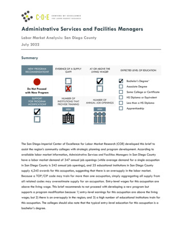
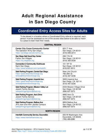
Figure 5. Community Plan Land Use Map- 14 -
PLAN SUMMARYThe San Ysidro Community Plan Map as illustrated (see Figure 5) is a visual representationof the major land use proposals set forth in each of the following plan elements. (See Table 2for recommended land use acreages.) The map by itself, however, does not constitute thePlan. The text of this document is equally necessary to interpret the intent of both thecommunity and the City of San Diego with respect to this area.The Plan map and text describe a future community comprised of residential, commercial,industrial and institutional land uses. The intent of the Plan is to provide comprehensivedevelopment standards and implementation recommendations to promote the physical andeconomic wellbeing of San Ysidro. The Plan is also intended to ensure that the community isproperly developed as the gateway to the City and to the United States.TABLE 2RECOMMENDED LAND USESLAND USEACREAGELow-Density Residential (5-10 dwelling units/net acre)280Low-Medium Density Residential (10-15 dwelling units/net acre)305Medium-Density Residential (15-30 dwelling units/net acre)149Commercial77Border Commercial184Industrial199Storage3Open Space149Park64*Institutional128Note: Including freeway and trolley rights-of-way, the total planning area acreage is approximately 1,802 acres.* See note on page 20.- 15 -
THE IMAGE OF SAN YSIDROThe following discussion of the image of San Ysidro is an excerpt from a presentation ofmajor community issues and goals by the San Ysidro Planning and Development Group tothe City of San Diego Planning Commission, December 8, 1988.San Ysidro is a collage of many different images. To some San Diegans, San Ysidro isthe City’s stepchild, not connected to it either physically or socially. To others, SanYsidro is the site of a terrible tragedy (the McDonald’s restaurant massacre in 1984). Toothers, it is a sleepy, dusty little border town, a low-income Hispanic community withlittle political clout. Perhaps the most significant and most damaging image of San Ysidrois that to many San Diegans, San Ysidro has no real image.To those who live, work, and play in San Ysidro, the community is at once all and noneof those things. There is a strong sense of community in San Ysidro with closely knitneighborhoods characterized by older homes and well-tended flower and vegetablegardens. It is a place where residents still know their neighbors and say “buenos dias” and“hello” to them in passing. There is still a small town atmosphere.Citizen involvement in the community is increasing. Many San Ysidro residents seemdetermined to change the image of San Ysidro by changing from within—by changingthemselves. They are working to create an image and a reality that will help San Ysidrothrive economically, be a pleasant and livable place, and that will not only meet basic needsbut provide amenities as well. They are working to create a place that offers both opportunityand hope for the future.Additional images that the San Ysidro community is working to change include: The image that San Ysidro is a bad place for business and that it is difficult to make aliving here; and The negative image of illegal immigration. The media focuses on the negative aspects ofliving on the border—for example, murders of illegal immigrants.ISSUES FACING SAN YSIDROImageMany of the images mentioned above are due, in part, to the following conditions: Few residents are involved with community political, planning and business groups. Residents feel powerless to make changes in their community. Community boundaries are poorly defined. The community is divided internally by social class and ethnicity.- 16 -
For example: Many Hispanic residents feel close ties to Mexico. Because of this, they often disassociatethemselves from local government and from the community’s problems. (For example,voter registration has historically been low.) A dual system has existed for many years in San Ysidro: social service agencies forHispanics and business and service organizations for the Anglos. In recent years, however,the business and service organizations have become more representative of thecommunity.Residential Many new multifamily housing developments have been built on land zoned anddesignated for commercial uses, and at densities much higher than adjacent single-familyneighborhoods. New residential development has not been sensitively designed and is threatening thehistoric small-scale character of San Ysidro’s neighborhoods. Much of the older housing stock is in need of rehabilitation, which many residents areunable to afford.Commercial Most of the commercial facilities in San Ysidro serve the tourist, not the resident. San Ysidro’s economy is dependent upon the Mexican consumer and as a result, hassuffered due to the instability of the Mexican economy in the 1980s. The majority of older businesses are in poor physical condition.International Gateway Despite its proximity to the border, San Ysidro has been unable to respond to thepossibilities for international trade and cultural exchange. There is a shortage of secure parking, good restaurants and shops, public informationcenters and comfort stations adjacent to the border and throughout the community. In response to the almost constant flow of illegal immigration, the Border Patrol maintainsa 24-hour watch over the border, and this situation has contributed to a feeling ofinsecurity, oppression, tension and fear among San Ysidro residents.Industrial Industrial development in San Ysidro faces formidable competition from Otay Mesa, thedeveloping community to the east, which has a significant amount of land designated forindustrial use.- 17 -
The probable closing of the Virginia Avenue commercial crossing within the next fewyears will cause many of the distribution and warehouse uses to relocate from San Ysidroto Otay Mesa, where a new crossing is located.Parks, Recreation and Open Space The community is deficient in parkland by approximately 20 acres. Some of the existing facilities are unimproved and lack turfed playing areas, parking andrecreation facilities. Existing open space areas are not protected with the appropriate land use designation andzoning, nor are they connected to each other. Access to the ocean at Border Field State Park is often closed due to sewage spills andflooding.Urban Form The community is divided by the trolley line, railroad tracks, I-5 and I-805. The southern portion of the community is isolated from the rest of the community and hasa poorly defined edge. The entrances to the community are unattractive and ill-defined. No central business district exists in this community. Development in the community does not reflect San Ysidro’s history, climate and ethnicidentity in project type and design.Transportation and Circulation The existing network of major and collector streets is old and inadequate and was notdesigned to serve existing or projected traffic volumes. There is no signage to direct tourists to parking areas, providers of Mexican insurance, andmoney exchange houses, which contributes to traffic problems as tourists drive around thecommunity searching for these services. There is an absence of sidewalks and pedestrian pathways throughout the community. The lack of parking along commercial corridors and the lack of border parking facilitiescauses business patrons and tourists to park in residential neighborhoods. There is an absence of signed and striped bikeways, including the 1,000-mile long PacificCoast Bicentennial bike route which terminates in San Ysidro.- 18 -
Public Facilities A number of residences in the older sections of the community are without sewer and gasservice. Adequate facilities and services were not provided in conjunction with the construction ofthe subsidized low-income housing. Several areas of the community are subject to periodic flooding due to the lack of stormdrains. Many of San Ysidro’s schools are overcrowded due to the unanticipated construction ofmultifamily units above the 1974 community plan forecast. San Ysidro’s proximity to the border and recent rapid growth are responsible for majorcrime problems, including gang-related violence.Cultural and Historic ResourcesInsensitively designed multifamily projects have damaged the historic fabric of thecommunity’s oldest neighborhood, “El Pueblito Viejo,” which includes a number ofCraftsman bungalows and Spanish Colonial Revival houses.OVERALL COMMUNITY GOALSImageStrengthen the Image of San Ysidro as a Community. A proud San Ysidro that recognizes and capitalizes on what it means to be of Mexicanheritage. A San Ysidro that involvesthe community and invitesparticipation from all of itsresidents in all aspects ofcommunity life. A San Ysidro that offersboth opportunity and hopefor the future and thatprovides excellence ineducation, jobopportunities, housing,health services andrecreation for all of itscitizens.- 19 -
Create an Image of San Ysidro as a Destination. A San Ysidro that invites andencourages visitors to stop and investin the community. A San Ysidro that people can enjoyand explore, where they can sampleMexican delicacies, and where theycan shop for “artesanias” (arts andcrafts). Develop an image of San Ysidro as agrand entrance into the United Statesand the City of San Diego.ResidentialCreate a safe and healthy livingenvironment and link residentialdevelopment to the provision ofadequate community facilities andservices.CommercialPreserve and enhance the community-oriented character in the historic commercial district;encourage the maintenance of existing uses and the development of new community-servingcommercial uses which meet the needs of the residents.International GatewayRecognize and capitalize upon the opportunities provided by the world's busiest bordercrossing.IndustrialPermit modest industrial growth to provide employment opportunities for residents andprovide a link to the industrial development in Otay Mesa to capitalize upon Otay Mesa’scommercial market.Parks, Recreation and Open SpaceProvide for a full and varied range of recreational opportunities accessible to all San Ysidroresidents by improving existing resources, designating additional community andneighborhood parks and preserving natural open space areas.- 20 -
Urban Form Develop a more cohesive San Ysidro, a community connected socially, visually andphysically. Eliminate barriers to pedestrian activity and enhance the pedestrian environment.Transportation and Circulation Develop a circulation system that provides for the smooth flow of traffic while allowingfor a response to the social and economic needs of the community. Increase and enhance mass transit and bicycle access.Public Facilities and ServicesProvide a full and balanced range of employment opportunities, medical facilities, publicworks and educational, social and recreational facilities and services.Cultural and Historic ResourcesRecognize, preserve and rehabilitate historically and architecturally significant buildings,districts, landscaped areas, archeological sites and urban environments.- 21 -
PLAN RECOMMENDATIONSSee each Plan element for a listing of these particular recommendations, and theImplementation Element for a complete listing of all Plan recommendations.1. Establish an International Gateway: a regional retail/visitor center which would includetourist amenities such as parking and transit facilities. This would create a specialdestination in San Ysidro and an appropriately grand entrance into the United States andthe City of San Diego.2. Organize and publicize community groups to increase participation in the community.3. Define the boundaries of San Ysidro to strengthen and solidify the residents’ sense ofcommunity by using entrance and directional signage, landscaping themes and otheridentifying markers.4. Work with the media and local businesses to stimulate an awareness of San Ysidro as anappealing place to live, work and visit.5. Require that necessary public facilities (roads, schools, parks, library) be provided at thetime of need. A Public Facilities Financing Plan will be incorporated into this Planconcurrent with Plan adoption to set forth the major public facilities needs and torecommend possible financing strategies.a. Provide adequate educational facilities and programs at the time of need. Existing andfuture school sites are identified in the Plan.b. Provide public parks and recreation facilities concurrent with need. Nine populationbased parks totaling 63.9 acres and two open space areas totaling approximately 149acres are identified in this Plan. Only two of these parks are fully developed as ofNovember 1989. Improvement and construction of the remaining parks is required bythe Plan as development proceeds. Funding sources for existing needs cannot includedevelopment impact fees.2. Provide attractive residential, commercial and industrial development. Ensure that thedevelopment will be compatible with adjacent land uses and will provide higher qualitysite planning and design. New development should be designed with attention toaesthetics, usability and safety. Attention to building bulk and scale is important, andbuilding articulation and architectural detail should be required for all projects.- 22 -
Low-Density Residential (5-10 dwelling units/net acre) 280 Low-Medium Density Residential (10-15 dwelling units/net acre) 305 Medium-Density Residential (15-30 dwelling units/net acre) 149 Commercial 77 Border Commercial 184 Industrial 199 Storage 3 Open Space 149 Park 64* Institutional 128 Note: Including freeway and trolley rights-of-way, the total planning area acreage is approximately .