Transcription
MN History Text 54/4MH 54-4 Winter 94-95.pdf 48/20/079:17 AMPage 1468/20/07 12:11:24 PM
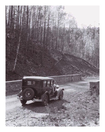
MN History Text 54/48/20/079:17 AMPage 147SNIVELY’SROADM A R KR Y A NWinding Mission Creek Road, native-stonebridge, and Hupmobile, about 1926In the late summer of 1929,dignitaries gathered to dedicateDuluth’s recently completedSkyline Parkway, a picturesquedrive winding high above LakeSuperior along the crest of thecity’s hills. Among those presentwas Mayor Samuel F. Snively, theman chiefly responsible for theconstruction and development ofthe unique boulevard system.Through personal determinationand a remarkable talent for raising donations, Snively broughtmore than three-quarters of theparkway to fruition, helpingestablish one of Duluth’s mostnoted landmarks.Terrace Parkway, as the initialportion of the road was firstcalled, was the brainchild ofWilliam K. Rogers, a native ofOhio who became president ofthe State Bank of Duluth and thecity’s first park board. In 1888Rogers had presented a plan fora hilltop boulevard that wouldfollow the ancient gravel shoreline left by glacial Lake Namadji,a larger ancestor of present-dayLake Superior. A companionpark stretching along LakeSuperior’s shore from SeventhAvenue East to Fortieth AvenueEast would be connected by perpendicular links following severalrivers and creeks that plungedfrom the crest of the hills towardthe lake. In the late 1880sMr. Ryan is a writer and film maker whoresides in Minneapolis. He grew up inDuluth near Seven Bridges Road.WINTER 1994MH 54-4 Winter 94-95.pdf 51478/20/07 12:11:24 PM
MN History Text 54/48/20/079:17 AMPage 148Equestrians explore Terrace Parkway in springtime, 1890sDuluth experienced a real estate boom, and cityofficials optimistically foresaw a populationgrowth of nearly half a million within five years.They deemed a park system such as the oneRogers suggested an essential advertising tool forpromoting the up-and-coming city.1During the last half of the nineteenth century,a strong park-building movement led byFrederick Law Olmsted was sweeping across theUnited States. As the size and density of the country’s population centers grew, the demand forurban open space also increased. Parks wereestablished in many cities, including New York’sCentral Park in 1853, Philadelphia’s FairmontPark in 1867, and Boston’s Franklin Park in 1883.Nor was park building restricted to urban settings.The country’s first national park, Yellowstone, wascreated in 1872, as were several county and statepark systems such as Minnesota’s, begun in 1891with Itasca State Park. Rogers’s plan for Duluth fitwell into the movement’s emphasis on followingthe natural contours and features of the land.2As early as 1887, Duluth’s board of publicworks had surveyed the natural boulevard linealong the crest of the hills, and a newspaper editorial that same year appealed to the city counciland citizens to develop a parks system. When thecity created a park board two years later, the1 Duluth Herald, Apr. 10, 1933, sec. 2, p. 6, Apr. 29, 1911, p. 25, Aug. 4, 1910, p. 8, hereafter Herald; R. L. Polkand Co.’s Duluth Directory, 1887–1888, p. 363; Duluth News Tribune, Mar. 31, 1935, p. 4, hereafter News Tribune;Dora M. McDonald, This Is Duluth (Duluth: Central H. S. Printing Dept., 1950), 12; Duluth Tribune, Jan. 21, 1887, p.4, hereafter Tribune; Duluth Dept. of Parks and Recreation, 1911 Annual Report of Board of Park Commissioners[n.p.].2 William D. Hunt, Jr., Encyclopedia of American Architecture (New York: McGraw-Hill, Inc., 1980), 399; CharlesE. Doell and Gerald B. Fitzgerald, A Brief History of Parks and Recreation in the United States (Chicago: AthleticInstitute, 1954), 58; Roy W. Meyer, Everyone’s Country Estate: A History of Minnesota’s Parks (St. Paul: MinnesotaHistorical Society Press, 1991), 5.148MH 54-4 Winter 94-95.pdf 6MINNESOTA HISTORY8/20/07 12:11:25 PM
MN History Text 54/48/20/079:17 AMPage 149A popular tallyho caravan, 1900sMinnesota legislature gave it the power to fundparks through municipal bonds. A 300,000 bondwas eventually issued, and work on the first leg ofTerrace Parkway began in 1889 under Rogers’sclose supervision. By midsummer three miles ofboulevard were nearly ready for use. When finished two years later at a cost of 312,000, theroadway ran 450 to 600 feet above lake level fromChester Creek in the east to Millers Creek inLincoln Park (then called Garfield). Rustic logsrimmed the drive, and granite boulders linedcurves, such as those around the small lakesknown as Twin Ponds.3“Tallyhos” became the popular vehicle forexcursions along the boulevard. Teams of four orsix horses usually pulled these single- and doubledecker coaches that seated up to 15 passengers.Luxury steamers coming from the east madeweekly calls to the port of Duluth, where tallyhoswould line the dock. They also stopped at thedowntown Spalding Hotel for riders. Coachingparties became a common sight, and tallyhocaravans carrying large groups of sightseers—as many as 30 wagonloads at a time—traveledalong the hilltop to present their passengerswith stunning panoramas of the city and itslarge harbor. When presidential candidateWilliam Jennings Bryan campaigned in Duluthin 1900, he toured the boulevard and reportedly agreed afterward with the local assessment that there was no finer drive in America.The Duluth Daily News claimed TerraceParkway’s only rival in the world was along theMediterranean. After Luther Mendenhall succeeded Rogers on the park board, that bodyeventually renamed the parkway RogersBoulevard. Despite its popularity, by century’send it still spanned only about five miles.43 McDonald, This Is Duluth, 95; Tribune, May 20, 1887, p. 4; Duluth Evening Herald, July 1, 1889, p. 3, July 11,1889, p. 3, hereafter Evening Herald; Herald, Aug. 4, 1910, p. 8; 1911 Report of Park Commissioners.4 Minneapolis Tribune, Jan. 19, 1964, Picture Magazine, p. 18; Evening Herald, Oct. 1, 1900, p. 1; McDonald, ThisIs Duluth, 96, 123; Herald, Apr. 10, 1933, sec. 2, p. 6; 1911 Report of Park Commissioners.WINTER 1994MH 54-4 Winter 94-95.pdf 78/20/07 12:11:25 PM149
MN History Text 54/48/20/079:17 AMPage 150Epersistence to turn dreams into reality, within anter Samuel Frisby Snively. Born nearfew short years he amassed a small fortune buyingGreencastle, Pennsylvania, on November 24,and selling real estate. He just as quickly lost it in1859, and a graduate of a Philadelphia lawthe panic of 1893 which swept across the country.9school, Snively had arrived in Duluth onSnively left the city a few years later to tryMarch 21, 1886. Twenty-six years old and withhis luck prospecting in the gold fields ofonly 15 in his pocket, he had by year’sAlaska. When that proved unsucend formed a partnership withcessful, he returned to Duluth,another lawyer, Charles P. Craig,where he established a realcreating what would become aestate business called thenotable law firm in the city’sSpring Garden Companyearly history.5and began developingSnively was a “goodproperty he owned in thesized man,” recalled hisback country above theniece, Zelda Snivelyeastern Duluth neighOverland. “Broad shoulborhoods of Lakesidedered, with a tenorand Lester Park. Invoice, steel-blue eyes,1901 he started buildlight brown hair. Greing a summer homegarious, outgoing, butthere. The house,stern. He didn’t foolwhich featured stonearound; he wasn’t thatwalls as much as twokind of person.”6feet thick, became theSnively’s short diacenterpiece of a 400ry, kept during his firstacre farm. Snively raisedyear in Duluth, reveals adairy cattle and feedman who worked hard atcrops, and the farm, profhis law practice and atitable from the start, wasbettering himself. He oftenknown for its beautiful setspent evenings working at histing and layout. Offering anoffice, socializing at the homesimpressive glimpse of Lakeof friends, or attending lecturesSuperior through nearby Amityon English literature. Walks aroundCreek valley, the property includedtown and visits to a gymnasiumSamuel Snively, father oftwo stone barns, a bunkhouse, and akept him in good physical health.7Duluth’s parkway systemsmall racetrack in front of theSnively’s diary also reveals thathouse. Farm guests could bet onhe spent much of his time as ahorse races or eat lunch in the pines along thelawyer examining abstracts for real estate transaccreek north of the house where he had designedtions. Seeing land prices beginning to surge firedand constructed several picnic sites with stonea new passion in the attorney. The final entry intables and benches.10his diary, dated January 27, 1887, reads: “SpentSnively had inherited his appreciation for thethe evening alone in the office drawing comoutdoors from his mother, Margaret H. Snively.plaints and dreaming over real estate.”8“My mother,” he once wrote, “was a woman ofLike the rivers and creeks cascading down therestless energy, a lover of all that was grand andslopes of his newfound city, Snively becamebeautiful in nature, and an influential representaknown as a “plunger.” Possessing the ability and5 Samuel F. Snively, “Autobiography,” Aug. 5, 1931, typescript, 2 p., biography file, Duluth Public Library; Herald,Jan. 23, 1938, p. 1, 2.6 Zelda Snively Overland, interview by author, tape recording in author’s possession, Duluth, May 17, 1991.7 Samuel F. Snively, Diary, Jan. 1, 1887, in possession of Douglas Overland, New Brighton, Minnesota. Snivelykept the diary from Jan. 9 until Jan. 27, 1887. Contained is a memoranda section with a few entries dated between Sept.10 and Oct. 8, 1888.8 Herald, Apr. 29, 1911, p. 25.9 News Tribune, Nov. 23, 1934, p. 1, 2, Jan. 23, 1938, p. 1, 2; Herald, Apr. 29, 1911, p. 25.10 Z. Overland interview; Durbin Keeney (former owner of Snively house), telephone interview with author, May18, 1991; News Tribune, May 7, 1911, sec. 3, p. 1, Jan. 23, 1938, p. 1, 2; Duluth Directory, 1898, p. 454; Henry A.Castle, Minnesota, Its Story and Biography (Chicago: Lewis Publishing Co., 1915), 2:811.150MH 54-4 Winter 94-95.pdf 8MINNESOTA HISTORY8/20/07 12:11:25 PM
MN History Text 54/48/20/079:17 AMPage 151tive of that which was most ennobling and uplifting in life.”11These were all traits that Snively himself possessed. He often took long treks alone surveyingand assessing his land until he knew every bywayand section. At the turn of the century he beganbuilding a road along Amity Creek, the westernbranch of the Lester River. “I was thenimpressed,” he recalled, “with the beauty of thisstream, its winding course, its dells and falls.”12Snively foresaw his road eventually joining upwith the planned eastern extension of RogersBoulevard. The hardships he saw in 1893 hadapparently sparked in him the dual-purpose ideaof developing the city boulevard system for posterity and providing jobs for the unemployed during hard times. “I knew the ownerships of the different tracts of land through which this roadwaywould extend,” he later stated, “and thought itprobable to secure this right of way on the theoryof having communications with other existingroadways. . . . After much writing and explaining,”he continued, “the right of way was pledged buton condition that the road should be built.”13Donating 60 acres of his own to the project,Snively appealed to fellow property owners forfinancial help to build the road. With 1,600 collected and money out of his own pocket, he beganconstruction in 1899. The city of Duluth pledgedan additional 1,500 with the stipulation that thecompleted road be turned over to the city. Snivelyhired men living nearby to do the work and himself supervised the progress.14“It was a very costly and difficult road tobuild,” he said. “Amid the dead and down timber,the brush and trees had grown, and there weremany trees and stumps all difficult of removal,and the nature of the creek demanded long andhigh bridges, and there was also the importantfeature of building the road to assure the bestscenic and park development without regard tothe ease of construction.”15Snively often joined in on the pick-and-shovelwork himself, a practice he would continue intohis eighties. “He loved to work,” recalled DouglasOverland, Snively’s great-nephew. “He was an extremely strong man. A powerful man. He’d jumpright into a hole and start digging with them.”16Building roads was in Snively’s blood. HisSwiss ancestors were engineers who had workedas surveyors for William Penn, platting whatwould later become Pennsylvania. Penn rewardedthem with two counties of land in theCumberland Valley, Samuel Snively’s birthplace,but all that remained of that inheritance for hisfather, Jacob S. Snively, was a small farm.17When completed, Snively’s road ran alongAmity Creek southwest into Colbyville near thesite of his new house. Concerned especially withthe beauty of the drive, he made it wind picturesquely into the hills through pine forests andcross the river in 10 places, for which he had rustic wooden bridges constructed. The venture wasonly partly altruistic, since the road also providedeasier access to his and other hilltop farms thanthe steep, older route. Remembering the project,Snively recalled that he “built the road north fromLester Park, including the bridges, and for a distance of about two and a half miles beyond, andthen stopped suddenly in a heavy bank of clay,feeling the need of financial refreshment.”18The pause gave citizens an opportunity toview the road’s progress and the beauty of thecreekside scenery. Additional donations came forward, and the road was finished in 1901. Twoyears later the city extended it westward toTwenty-Sixth Avenue East and Third Street inDuluth’s east hillside district. In the end SnivelyRoad (as it came to be called) cost more than 12,000, nearly half of which came from his ownpocket. Although he also had plans to build a parallel roadway on the other side of the ridge, forthe time being he handed over his road to the cityand turned his attention back to his farm, his mining interests on Minnesota’s Mesabi Iron Range,and his real estate activities.19Meanwhile, Duluth continued to enhance andadvertise the celebrated, if short, Rogers Boule-11“Autobiography.”Douglas Overland, interview with author, tape recording in author’s possession, New Brighton, May 23, 1991;News Tribune, Nov. 11, 1934, feature sec., p. 1, July 6, 1912, p. 7, Apr. 7, 1937, p. 3.13 News Tribune, July 6, 1912, p. 7, Mar. 19, 1939, p. 12.14 Legal notice, Herald, July 29, 1911, p. 26; News Tribune, Jan. 23, 1938, p. 1, July 6, 1912, p. 7; Evening Herald,May 18, 1900.15 News Tribune, July 6, 1912, p. 7.16 Herald, Nov. 26, 1926, p. 8, Nov. 24, 1934, p. 1; News Tribune, Nov. 11, 1934, feature sec., p. 1; D. Overlandinterview.17 “Autobiography”; Herald, Nov. 7, 1952, p. 1.18 Herald, Nov. 7, 1903, p. 13; News Tribune, July 6, 1912, p. 7.19 Herald, Nov. 7, 1903, p. 13; News Tribune, July 6, 1912, p. 7, Nov. 11, 1934, feature sec., p. 1.12WINTER 1994MH 54-4 Winter 94-95.pdf 98/20/07 12:11:25 PM151
MN History Text 54/48/20/079:17 AMPage 152vard. To replace the aging fence that had lined it,the park board planted more than 2,000 trees. By1907 an additional three miles of road had beenstarted to the west. A portion of this was the workof Leonidas Merritt, one of the original discoverers of the Mesabi Range. The park board reimbursed Merritt for his effort and later finished theextension with money from a 50,000 bond issuedin 1910.20That same summer, the Duluth Herald organized a contest to rename the expanding boulevard system (and, no doubt, sell papers). Becausethe official name, Rogers Boulevard, had neverachieved much popularity—most people simplyreferred to it as “The Boulevard”—the paper’seditors called for a more descriptive title to helppromote it, especially to out-of-towners. The finalchoice, an announcement read, would be left upto the park board, but the reader who suggestedthe winning name would receive a 10 checkfrom the newspaper.21Over the summer some 1,500 entries fromaround the state and as far away as New Yorkpoured in. Among the possibilities were suchnames as Kitchi Gammi Drive, Lovers’ Lane, Zenith Promenade, Hillcrest Boulevard, and GrandView Drive. The names Skyline Drive and SkylineParkway were even offered, but they would haveto wait several decades to be appreciated.22While a number of citizens including the parkboard’s Mendenhall protested that the boulevardalready had a name, the contest continued. In theend, not surprisingly, the park board chose readerAda White’s suggestion: Rogers Boulevard. Asbefore, the name never caught on, and within afew months the paper was again referring to thedrive simply as “The Boulevard.”23Meanwhile, Snively Road, transferred fromthe city to the park board in 1909, had falleninto disrepair. Weeds had overgrown it andthe rustic bridges had fallen to ruin, making20McDonald, This Is Duluth, 123; Herald, Apr. 10, 1933, sec. 2, p. 6, Sept. 8, 1910, p. 15, Oct. 31, 1910, p. 11;Official Proceedings (city council), Herald, Sept. 8, 1910, p. 15; Evening Herald, July 9, 1904, p. 7.21 Herald, Aug. 5, 1910, p. 12.22 Herald, Aug. 3, p. 7, Aug. 4, p. 3, Aug. 5, p. 5, Aug. 6, p. 15, Aug 8, p. 8, Aug. 9, p. 9—all 1910.23 Herald, Aug. 12, p. 5, Sept. 2, p. 2, Oct. 31, p. 11—all 1910.Road building along rugged hilltops, 1910s152MINNESOTA HISTORYMH 54-4 Winter 94-95.pdf 108/20/07 12:11:26 PM
MN History Text 54/48/20/079:17 AMPage 153One of nine stone-arch bridges along Snively Roadthe drive useless to automobiles and carriages.Only pedestrians who did not mind the occasionalrough footing or wading across the creek enjoyedits beauty. A year later the park board announcedthat money from the bond issued for the westernextension of Rogers Boulevard would also be usedto upgrade Snively Road. The improvementwould include hiring landscape architects todesign new bridges. When completed, the roadwould officially become part of the city’s growinghilltop boulevard system.24The board’s plan, of course, was good news toSnively: “It greatly pleased me, for it assured theconsummation of the very purpose I had in view,the appropriation by the city for park and boulevard purposes of some of the most scenic and natural park property in and about the city.” Duringthe next two years the park board surveyed,cleared, and regraded the road and began con-struction on nine stone-arch bridges. Snivelyassisted during the preparatory stages, often joining park-board meetings, consulting privately withcommissioners, and accompanying them oninspection tours.25Designing the handsome bridges was theMinneapolis firm of Morell and Nichols. Wellknown in Duluth, Anthony U. Morell andArthur F. Nichols had created the landscaping atChester A. Congdon’s Duluth estate, as well asCongdon Park. The nine concrete structures theydesigned were faced with native granite, blastedfrom cliffs in the vicinity and collected from thecreek bed. Six-inch copings made of pink opalgranite quarried near St. Cloud detailed thelength of the bridge walls and piers, completingthe design. A tenth bridge, modestly made of concrete and iron pipe, connected the parkway toSnively’s farm.2624 Herald, Oct. 24, 1910, p. 11, Oct. 25, 1910, p. 8, Apr. 3, 1911, p. 2, July 5, 1912, p. 12; News Tribune, Apr. 9,1911, p. 8, Apr. 23, 1911, p. 16.25 News Tribune, July 6, 1912, p. 7; Herald, Oct. 31, 1910, p. 11, Nov. 15, 1910, p. 7.26 Herald, Apr. 3, 1911, p. 2, July 5, 1912, p. 12; News Tribune, Apr. 9, 1911, p. 8, Apr. 23, 1911, p. 16, July 6, 1912,p. 7; Greg Kopischke, “Morell & Nichols: An Influential and Productive Partnership,” Minnesota Common Ground 1(Winter 1994): 7; Timothy Howard, Duluth Parks and Recreation Dept., telephone and personal interviews withauthor, Mar. 31, 1993; bridge blueprints, Morell & Nichols Papers, Northwest Architectural Archives, University ofMinnesota, St. Paul.WINTER 1994MH 54-4 Winter 94-95.pdf 118/20/07 12:11:26 PM153
MN History Text 54/48/20/079:17 AMPage 154In the summer of 1912 Snively Roadreopened, thereby adding nearly six miles toDuluth’s growing boulevard system. RenamedAmity Boulevard, it was touted as one of the city’sfinest beauty spots. Wildflowers lined much of thedrive. Its stone bridges frequently appeared onpostcards and in park brochures.27When Duluth changed to the commissionform of government in 1913, the park board disbanded, and improvements to park property,including the boulevard system,declined for the next few years andduring World War I. Snively, however,continued donating property to thecity for parks and boulevards, as didmen such as Congdon, who gave theright-of-way for Congdon Parkwayalong Lake Superior.281930s. Throughout his four terms of office—thelongest in Duluth’s history—Snively remainedrespected for his leadership, enthusiasm, andcompassion.30The new mayor’s duties included heading thecity’s parks and boulevards department, a taskSnively surely relished. In this capacity, he immediately announced his administration’s chief aim:“Duluth should have the finest system of parksand boulevards in America. It is my great ambi-On October 12, 1918, one of thecountry’s most devastating forestfires hit northern Minnesota.Gale-force winds drove the fireeastward from its origin near Bemidji,and whole towns burned to theground. More than 500 people perSightseers enjoying a view of Minnesota Point, about 1919ished, most within a 50-mile radius ofDuluth. While the city served as ahaven for survivors, the hillside outskirts were lesstion to see this plan realized.” Snively’s planlucky. Pockets of fire scathed the forest and land,included resurrecting the park board and expandrazing some 200 structures near or along Snivelying on Rogers’s original concept of linkingRoad. Snively’s stone house remained untouchedDuluth’s parks and playgrounds with boulevards(and still stands today), but all of his other buildfrom one end of the city to the other.31ings burned to the ground, and many of his thorWhen Snively took office, the existing bouleoughbred animals died.29vard stretched only about eight miles fromChester Creek west to Oneota Cemetery. InOut of the ashes rose the phoenix of Snively’sbetween, it circled Central Park (near wheredormant dream for Duluth’s boulevard. ListingEnger Tower stands today) and intersected onlyhis title as president of the Duluth Land andtwo ravine parks: Chester and Lincoln. On theDevelopment Company, Snively filed as a candieast end, Lester Park and the additional six milesdate for mayor in February 1921. Two monthsof Snively’s Amity Boulevard formed a terminus tolater the political neophyte won office. Althoughthe system, isolated by a two-mile gap betweenalready 61 years old, he would serve Duluth forCongdon and Chester Parks.32the next 16 years, leading the city through thehigh times of the 1920s and the depression of theMayor Snively first set to work extending the27News Tribune, July 3, 1912, p. 16, July 6, 1912, p. 7; Herald, July 3, 1912, p. 5, July 5, 1912, p. 12.Herald, Apr. 10, 1933, sec. 2, p. 6; Deeds 425 and 464, Records Office, St. Louis County Courthouse, Duluth.29 News Tribune, Oct. 13, 1918, p. 1, Oct. 18, 1918, p. 4; Minneapolis Morning Tribune, Oct. 15, 1918, p. 4; Keeneyinterview.30 News Tribune, Feb. 2, 1921, p. 1, Apr. 6, 1921, p. 1, Apr. 15, 1937, p. 1, Oct. 4, 1924, p. 6; Labor World, Jan. 14,1933, p. 1, Apr. 1, 1933, p. 3; Samuel W. Morris, “Having My Say-So,” Duluth Steel Plant News, Feb. 11, 1933, clipping, from four clipping scrapbooks compiled 1924–37 by Snively’s secretary, Alta Marie Johnson, in possession ofDouglas Overland (hereafter, scrapbooks); Herald, Apr. 15, 1937, p. 15.31 News Tribune, Apr. 22, 1921, p. 1, May 27, 1921, p. 2; Duluth Advertiser, Nov. 12, 1925, scrapbooks; LaborWorld, Jan. 17, 1925, p. 1.32 Duluth-Superior map (St. Paul: McGill-Warner Co., 1921), copy in Minnesota Historical Society, St. Paul;Herald, Nov. 16, 1927, p. 10.28154MINNESOTA HISTORYMH 54-4 Winter 94-95.pdf 128/20/07 12:11:26 PM
MN History Text 54/48/20/079:17 AMPage 155boulevard westward beyond Rest Point (near present-day Interstate 35) and around Bardon’s Peakto a junction with Becks Road above Duluth’swesternmost suburbs. Work on the new road, referred to in city records as the “Mayor’s BoulevardExtension,” progressed during the early 1920s.While crews tackled one section, Snively busily acquired the rights-of-way for the next. Some mornings the mayor would show up at the work site cladin overalls, ready to dig as well as supervise. Otherdays he hosted early-morning tours to view theprogress, and citizens interested in joining themotorcade were instructed to notify his office.33When the new western extension opened inthe summer of 1925, the entire system waspraised by local newspapers as “one of the outstanding scenic driveways of the world” and “anasset beyond price.” These were not exaggerations. Spectacular views overlooking Lake Superior took in the entire expanse of Duluth, as wellas a good portion of Wisconsin along the lake’ssouthern shore. On clear days the Apostle Islandswere visible some 60 miles away.34In announcing his bid for reelection in 1925,Mayor Snively pointed proudly to his record:“Since I came into office I built some nine milesof boulevard.” In his first term he had more thandoubled the length of the original Rogers Boulevard and had also increased overall park space inthe city. Before Snively took office, the parkdepartment claimed some 405 acres in park area,excluding boulevard rights-of-way; by 1923 thetotal had grown to nearly 1,780 acres, and by mid1926 it would expand to about 2,500 acres.35While criticism often arose regarding the outlay of public funds for Snively’s park and boulevard projects, more than 60 percent of the properties acquired during his first term had beendonated by citizens at no cost to the city. Heremained convinced that his program would servethe city well. “I do not believe that the people ofDuluth yet realize how our grand scenic driveways are advertising our city. . . . Go where youwill and meet anyone who in the last few years hasvisited Duluth, and at once our wonderful scenicdriveways are mentioned. It is the outstandingfeature in our city that impresses itself most uponour visitors.”36Although the boulevard was his favorite project, Snively also helped establish and improveother Duluth parks including Memorial,Congdon, Brighton Beach along Superior’s northshore, and Fairmont (which housed the predecessor of the Lake Superior Zoo). Snively also madeimprovements to Lakeshore Park (renamed LeifErikson Park in 1927) and advocated building amunicipal nursery in Fond du Lac on the west.Smaller parcels also received the mayor’s attention, and he pushed successfully for the construction of several playgrounds. Although he nevermarried, Snively kept a place in his heart for chil-Snively and great-nephew Douglas Overland33 Dept. of Public Works, Engineering Div.,Records, City Hall, Duluth; News Tribune, Oct. 4, 1924,p. 6; Herald, Oct. 20, p. 22, Oct. 21, p. 10, Nov. 15, p.4—all 1924.34 Herald, May 25, 1925, editorial, p. 12; NewsTribune, Oct. 4, 1924, p. 6; “Duluth, Minnesota: WhereRails and Water Meet,” visitor brochure, 1929, copy inMinnesota Historical Society, St. Paul.35 Labor World, Jan. 17, 1925, p. 1; News Tribune,Aug. 25, 1923, p. 6; Herald, Nov. 16, 1927, p. 10.36 News Tribune, Nov. 18, 1924, p. 1; Labor World,Jan. 17, 1925, p. 1; Herald, June 8, 1928, p. 19.WINTER 1994MH 54-4 Winter 94-95.pdf 138/20/07 12:11:27 PM155
MN History Text 54/48/20/079:17 AMPage 156dren. During the 1930s he initiated annual picnicsat the zoo for the city’s orphans, which he personally hosted.37After a solid victory in the 1925 election,Snively set to work completing the last linkof the western extension: a 2.25-mile roadalong Mission Creek connecting the upperboulevard with Jay Cooke State Park southwest ofDuluth. Created around 1915 by an act of theMinnesota legislature, the park was accessibleonly from the west on a road that dead-ended 3.5miles inside its boundary. Visitors from Duluthfaced a 20-mile trip to enter the park, and touristsfrom the Twin Cities had to backtrack toHighway 1 in order to continue on to Duluth.Snively wanted to eliminate this inconvenience.He grandly dreamed about making the city’sboulevard connection to the park part of a roadsystem reaching from southern Minnesotathrough Duluth to Canada on the soon-to-becompleted highway along Lake Superior. Fivestone bridges and two railroad crossings would benecessary for the joint effort among Duluth,Carlton County, and two railroads, the NorthernPacific and the Duluth, Missabe & Northern.38Snively saw this Mission Creek road as complementing his eastern Amity Creek drive, bookends to the city’s boulevard system. But he hit aroadblock when members of the Fond du LacCommunity Club complained that the new roadwould bypass their community. The mayorappeased them by promising an additional connecting link.39As work on the main link progressed throughthe spring and summer of 1926, Snively beganmaking good on his promise to the people ofFond du Lac. After learning that the additional37 Herald, May 16, 1921, editorial, p. 10, Oct. 29,1926, p. 8, Sept. 27, 1926, p. 6, June 13, 1925, p. 3, Nov.19, 1925, p. 1, July 28, 1936, p. 2; Labor World, Jan. 17,1925, p. 1; News Tribune, Nov. 18, 1924, p. 1, Aug. 1,1927, p. 1, Aug. 13, 1931, p. 2.38 News Tribune, Apr. 8, 1926, p. 6, Aug. 4, 1929, p.1, June 20, 1925, p. 5, Nov. 26, 1926, p. 8; Herald, June11, 1925, p. 7, June 13, 1925, p. 3, Sept. 24, 1926, p. 20,Dec. 31, 1927, p. 23; Meyer, Everyone’s Country Estate,45–49.39 Information in Snively’s handwriting from back ofMission Creek Road photograph, in possession ofDouglas Overland; Herald, Dec. 22, 1925, p. 8.Chambers Grove at Fond du Lac, parkland acquiredfor development as a tourist resort156MINNESOTA HISTORYMH 54-4 Winter 94-95.pdf 148/20/07 12:11:27 PM
MN History Text 54/48/20/079:17 AMPage 157WINTER 1994MH 54-4 Winter 94-95.pdf 158/20/07 12:11:27 PM157
MN History Text 54
along the crest of the hills, and a newspaper edito-rial that same year appealed to the city council and citizens to develop a parks system. When the city created a park board two years later, the 1 Duluth Herald,Apr. 10, 1933, sec. 2, p. 6, Apr. 29, 1911, p. 25, Aug. 4, 1910, p. 8, hereafter Herald; R. L. Polk