Transcription
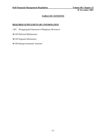
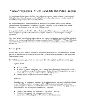
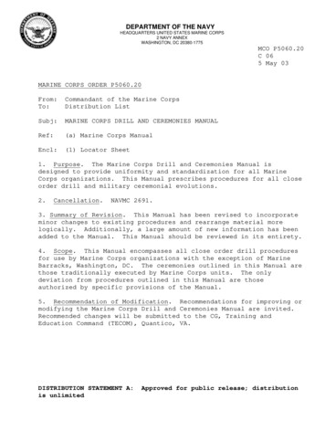
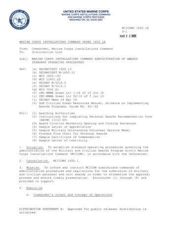
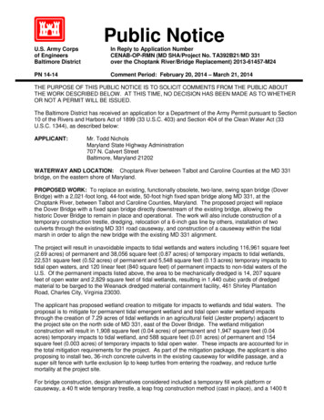
Public NoticeU.S. Army Corpsof EngineersBaltimore DistrictIn Reply to Application NumberCENAB-OP-RMN (MD SHA/Project No. TA392B21/MD 331over the Choptank River/Bridge Replacement) 2013-61457-M24PN 14-14Comment Period: February 20, 2014 – March 21, 2014THE PURPOSE OF THIS PUBLIC NOTICE IS TO SOLICIT COMMENTS FROM THE PUBLIC ABOUTTHE WORK DESCRIBED BELOW. AT THIS TIME, NO DECISION HAS BEEN MADE AS TO WHETHEROR NOT A PERMIT WILL BE ISSUED.The Baltimore District has received an application for a Department of the Army Permit pursuant to Section10 of the Rivers and Harbors Act of 1899 (33 U.S.C. 403) and Section 404 of the Clean Water Act (33U.S.C. 1344), as described below:APPLICANT:Mr. Todd NicholsMaryland State Highway Administration707 N. Calvert StreetBaltimore, Maryland 21202WATERWAY AND LOCATION: Choptank River between Talbot and Caroline Counties at the MD 331bridge, on the eastern shore of Maryland.PROPOSED WORK: To replace an existing, functionally obsolete, two-lane, swing span bridge (DoverBridge) with a 2,021-foot long, 44-foot wide, 50-foot high fixed span bridge along MD 331, at theChoptank River, between Talbot and Caroline Counties, Maryland. The proposed project will replacethe Dover Bridge with a fixed span bridge directly downstream of the existing bridge, allowing thehistoric Dover Bridge to remain in place and operational. The work will also include construction of atemporary construction trestle, dredging, relocation of a 6-inch gas line by others, installation of twoculverts through the existing MD 331 road causeway, and construction of a causeway within the tidalmarsh in order to align the new bridge with the existing MD 331 alignment.The project will result in unavoidable impacts to tidal wetlands and waters including 116,961 square feet(2.69 acres) of permanent and 38,056 square feet (0.87 acres) of temporary impacts to tidal wetlands,22,531 square feet (0.52 acres) of permanent and 5,548 square feet (0.13 acres) temporary impacts totidal open waters, and 120 linear feet (840 square feet) of permanent impacts to non-tidal waters of theU.S. Of the permanent impacts listed above, the area to be mechanically dredged is 14, 207 squarefeet of open water and 2,829 square feet of tidal wetlands, resulting in 1,440 cubic yards of dredgedmaterial to be barged to the Weanack dredged material containment facility, 461 Shirley PlantationRoad, Charles City, Virginia 23030.The applicant has proposed wetland creation to mitigate for impacts to wetlands and tidal waters. Theproposal is to mitigate for permanent tidal emergent wetland and tidal open water wetland impactsthrough the creation of 7.29 acres of tidal wetlands in an agricultural field (Jester property) adjacent tothe project site on the north side of MD 331, east of the Dover Bridge. The wetland mitigationconstruction will result in 1,908 square feet (0.04 acres) of permanent and 1,947 square feet (0.04acres) temporary impacts to tidal wetland, and 588 square feet (0.01 acres) of permanent and 154square feet (0.003 acres) of temporary impacts to tidal open water. These impacts are accounted for inthe total mitigation requirements for the project. As part of the mitigation package, the applicant is alsoproposing to install two, 36-inch concrete culverts in the existing causeway for wildlife passage, and asuper silt fence with turtle exclusion lip to keep turtles from entering the roadway, and reduce turtlemortality at the project site.For bridge construction, design alternatives considered included a temporary fill work platform orcauseway, a 40 ft wide temporary trestle, a leap frog construction method (cast in place), and a 1400 ft
-2bridge extension. The temporary construction trestle avoids fill in tidal wetlands and is the preferredconstruction access alternative.All work is to be completed in accordance with the enclosed plan(s). If you have any questions concerningthis matter, please contact Mrs. Mary Frazier at 410-962-5679 or Mary.A.Frazier@usace.army.mil.The decision whether to issue a permit will be based on an evaluation of the probable impact includingcumulative impacts of the proposed activity on the public interest. That decision will reflect the nationalconcern for both protection and utilization of important resources. The benefit which reasonably may beexpected to accrue from the proposal must be balanced against its reasonably foreseeable detriments. Allfactors which may be relevant to the proposal will be considered including the cumulative effects thereof;among those are conservation, economics, aesthetics, general environmental concerns, wetlands, culturalvalues, fish and wildlife values, flood hazards, flood plainvalues, land use, navigation, shoreline erosion and accretion, recreation, water supply and conservation,water quality, energy needs, safety, food and fiber production, and, in general, the needs and welfare of thepeople.The evaluation of the impact of the work described above on the public interest will include application ofthe Clean Water Act Section 404 (b) (1) Guidelines promulgated by the Administrator, U.S. EnvironmentalProtection Agency, under the authority of the Section 404 of the Clean Water Act.The Corps of Engineers is soliciting comments from the public; Federal, State, and local agencies andofficials; Indian Tribes; and other interested parties in order to consider and evaluate the impacts of thisproposed activity. Any comments received will be considered by the Corps of Engineers to determinewhether to issue, modify, condition or deny a permit for this proposal. To make this decision, commentsare used to assess impacts on endangered species, historic properties, water quality, generalenvironmental effects, and the other public interest factors listed above. Comments are used in thepreparation of an Environmental Assessment and/or an Environmental Impact Statement pursuant tothe National Environmental Policy Act. Comments are also used to determine the need for a publichearing and to determine the overall public interest of the proposed activity.Written comments concerning the work described above related to the factors listed above or otherpertinent factors must be received by the District Engineer, U.S. Army Corps of Engineers, BaltimoreDistrict, ATTN: Mrs. Mary Frazier, CENAB-OP-RMN, P.O. Box 1715, Baltimore, Maryland 21203-1715,within the comment period specified above.ESSENTIAL FISH HABITAT: The Magnuson-Stevens Fishery Conservation and Management Act(MSFCMA), as amended by the Sustainable Fisheries Act of 1996 (Public Law 04-267), requires allFederal agencies to consult with the National Marine Fisheries Service (NMFS) on all actions, orproposed actions, permitted, funded, or undertaken by the agency that may adversely affect essentialfish habitat (EFH).The project site lies in or adjacent to EFH as described under MSFCMA for Scopthalmus aquosos(windowpane flounder) juvenile and adult; Pomatomus saltatrix (blue fish) juvenile and adult;Paralicthys dentatus (summer flounder) juvenile and adult; Peprilis triacanthos (Atlantic butterfish) eggs,larvae, juvenile and adult ; Centropristus striata (black sea bass) juvenileand adult; eggs, larvae, juvenile, and adult stages of Sciaenops ocellatus (red drum), Scomberomoruscavalla (king mackerel), Scomberomorus maculatus (spanish mackerel), and Rachycentron canadum(cobia), all managed species under the MSFCMA.The project has the potential to adversely affect EFH or the species of concern by loss ofnursery, forage and/or shelter habitat. The project may have an adverse effect on Essential FishHabitat as described under the Magnuson-Stevens Fishery Conservation and Management Act for thespecies and life stages identified above. However, the District Engineer has made a preliminarydetermination that site-specific impacts would not be substantial and an abbreviated consultation will be
-3conducted with NMFS. This determination may be modified if additional information indicates otherwiseand would change the preliminary determination.SECTION 401 WATER QUALITY CERTIFICATION: The applicant is required to obtain a water qualitycertification in accordance with Section 401 of the Clean Water Act from the Maryland Department ofthe Environment. Any written comments concerning the work described above which relate to waterquality certification must be received by the Maryland Department of the Environment, Tidal WetlandsDivision, Montgomery Park Business Center, 1800 Washington Boulevard, Suite 430, Baltimore,Maryland 21230, within the comment period as specified above to receive consideration. The Section401 certifying agency has a statutory limit of one year from the date of this public notice to make itsdecision.COASTAL ZONE MANAGEMENT PROGRAM: The applicant has certified in this application that theproposed activity complies with and will be conducted in a manner consistent with the State’s federallyapproved Coastal Zone Management Program (CZMP). By this public notice, we are requesting theState’s concurrence or objection to the applicant’s consistency certification statement. It should benoted that Maryland’s CZMP has a statutory limit of 6 months to make its consistency determination.The applicant must obtain any State or local government permits which may be required.A preliminary review of this application indicates that the proposed work will not affect listed species ortheir critical habitat pursuant to Section 7 of the Endangered Species Act as amended. As theevaluation of this application continues, additional information may become available which couldmodify this preliminary determination.Review of the latest published version of the National Register of Historic Places indicates that noregistered properties listed as eligible for inclusion therein are located at the site of the proposed work.Currently unknown archeological, scientific, prehistoric, or historical data may be lost or destroyed bythe work to be accomplished under the requested permit.Any person who has an interest which may be adversely affected by the issuance of this permit mayrequest a public hearing. The request, which must be in writing, must be received by the DistrictEngineer, U.S. Army Corps of Engineers, Baltimore District, [Attn: Mrs. Mary Frazier, CENAB-OPRMN], P.O. Box 1715, Baltimore, Maryland 21203-1715, within the comment period as specified asabove to receive consideration. Also, it must clearly state forth the interest which may be adverselyaffected by this activity and the manner in which the interest may be adversely affected.It is requested that you communicate the foregoing information concerning the proposed work to anypersons known by you to be interested and not being known to this office, who did not receive a copy ofthis notice.FOR THE DISTRICT ENGINEER:JOSEPH P. DAVIAChief, Maryland Section Northern
\/./'-·j/'/.::-l:;:i', J \}'.f., . ,.,.::PROJECTLOCATIONi"l.-·- - .:'.'·.'""- .-,./··-. . - - -i''//VICINITY MAPSMASTATE OF MARYlANDDEPARTMENT OF TRANSPORTATIONSTATE HIGHWAY ADMINISTRATIONMD 331 (DOVER ROAD) OVER CHOPTANK RIVERBRIDGE (NO. 2003400) REPLACEMENT - SHA CONT. NO. TA3925171TALBOT & CAROLINE COUN1Y, MDDATEJULY 2013020004000SCALE IN FEET8000
PLOTIED: Friday, January 31,2014 AT 10:59 AMFILE: U: \Projects \AA\20834 -CAD\00 pWP-f001 MD331.dgn .N//)'0 0';, //01-., o""///// 0.----- .--"' " . . .---, vc /.-- .--/.-.//.,,./'-.-----.-----.---/, ."' :1/'1:-" ·-- ,, '"'///// -,. . 4./(/I/IIr- --.J n·-'l\ "'n\oczc \ngro 0 "' \.I\KEY PLAN & LOCATION MAPSTATE OF MARYLANDDEPARTMENT OF TRANSPORTATIONSTATE HIGHWAY ADMINISTRATIONMD 331 (DOVER ROAD) OVER CHOPTANK RIVERBRIDGE (NO. 2003400) REPLACEMENT - SHA CONT. NO. TA3925171TALBOT & CAROLINE COUNTY, MDDATELOCATION MAPJULY 201305001000SCALE IN FEET2000
PLOTIED: Thursday, February 06, 2014 AT 03·41 PMFILE: U: \Projects\AA\20834 CAD\00 pWP-F002 MD331.dgnSummary of ImpactsLegendFEATURESTIDAL WETLAND:PERMANENT WETLAND25' NON-TIDAL WETLAND BUFFER:BBUFFERPERMANENT TEMPORARY -wus-WATERS OF U.S.NON-TIDAL WATERS OF THE U.S.:PERMANENT TEMPORARY 0II84000225312356230100000568OPEN WATER TIDAL WETLANDS:PERMANENT TEMPORARY 554816190DEl'AIL BREAKOOWN(INCLUOED IN WETLAND IMPACT TOTALS):VEGETATED TIDAL WETLAND FOR BRIDGE CONSTRUCTION:PERMANENT 33200TEMPORARY I0 I0 I0ILOD-LIMIT OF DISTURBANCETEMPORARY III106332048802803309315400000000PERMANENT TEMPORARY HISTORIC SITE--H--CAB-TEMPORARY VEGETATEDTIDAL WETLAND IMPACTS- PERMANENT VEGETATEDTIDAL WETLAND IMPACTSTEMPORARY OPEN WATERTIDAL WETLAND IMPACTS- PERMANENT OPEN WATERTIDAL WETLAND IMPACTSTEMPORARY NON-TIDAL WATERSOF THE US IMPACTS-FILL FOR ROADWAY EMBANKMENT STABILIZATION:PERMANt:NI 200500TEMPORARY 0PERMANENT NON-TIDAL WATERSOF THE US IMPACTS- .PERMANENT OPEN WATER AND VEGETATED TIDAL WETLAND IMPACT 139,492 SF(3.20Ac)TEMPORARY OPEN WATER AND VEGETATED TlDAL WEnAND IMPACT ( 1 OOAc)TOTAL 183.096 SF( 4.20Ac.)M1t1gattonRatto1.18.324 SF14.207 SF(0.33 Ac)1:114.207 SF( 0.33 Ac.)5,548 SF(0.13Ac.)0.1OSF( O.OOAc.)PERMANENT VEGETATED TlDAL WETLAND IMPACT 116.871 SF( 2.68 Ac.)21233.742 SF( 5.37 Ac.)TEMPORARY VEGETATED llDAL WEnAND IMPACT 3.783 SF( .09Ac)2:17,566 SF( .17 Ac.)34,273 SF0:1OSF( .OOAc.)90 SF( .79Ac.)( .00 Ac)183.096 SF(4.21 Ac)TEMPORARY OPEN WATER IMPACT TEMPORARY VEGETATED llDAL WETLAND IMPACT FOR TRESTLE PERMANENT VEGETATED llDAL WETLAND IMPACT FOR TRESnE PILES TOTAL llDAL WETLAND IMPACTTIDAL WETLAND MITIGAllON PROVIDED OFFSITE TlDAL WETLAND MITIGAllON PROVIDED ON SITE (BRIDGE SHADING') 21PERMANENT STABILIZING BERMTIDAL WETLAND IMPACTS-!PERMANENT BRIDGE SHADING. TIDAL WETLAND IMPACT- "' """'""""'""""'"" te ::S .;l!::S .;l! t::sMitigaiion(0.19Ac.)PERMANENT OPEN WATER IMPACT FOR DREDGING - 8.324 SFPERMANENT OPEN WATER IMPACT V / / /][L// LJI000VEGETATED TIDAL WETLAND FOR TEMPORARY TRESTLE BRIDGE CONSTRUCTION:I PERMANENT I90 I0 I0 I40 I40TEMPORARY 'AREA UNDER BRIDGE WHERE H!'N 0.7-csc.A-IMPACTSFILL FOR ROADWAY:TOTAL llDAL WE nAND MITlGA TlON PROVIDED CHESAPEAKE BAYCRITICAL. AREACRITICAL AREABUFFER(0.19Ac.)180 SF( OOAc.)264.019 SF(606Ac)6.90 Ac.39 A c.SUMMARY OF IMPACTSSMASTATE OF MARYLANDDEPARTMENT OF TRANSPORTATIONSTATE HIGHWAY ADMINISTRATIONMD 331 (DOVER ROAD) OVER CHOPTANK RIVERBRIDGE (NO. 2003400} REPLACEMENT - SHA CONT. NO. TA3925171TALBOT & CAROLINE COUNTY, MD7 29AcDATEJULY 2013SCALE IN FEET
PLOTTCJ F!:day ,) H1LJary 31. 2U14 ,t.J iO 59 ?.tv FIL[. U \ ProJ Cts \AA \20834 78!::\ Reports\ Wet!arldMit:got:onFr:::!nlitPicttt''S \ Gra:;, 1ics ··CAD\ 0': :-:'v\'P ··POO: r-110331 dg 1" .' .,r:F/ 6'.f:;: ,., .llrsj-. "' / -/ / ',- c''IINC ,,-f.IHk( u :H.,Hr .H/r'-Y.PHOP FIW----·0··---- - -- - C - - "-.-:-': C -.::. · -.:.:: i: :.: ·.:. :: ;.,· ,-:·: ·r -- .-,,.------- ---c----- -c-.,.---e-----c--CONSTRUCT!ON STAGING AREA-'S"f AGII .iG P REA/l;t·.J01'-i-TIDAL WUS iMPACTF·GFi S'NM OUTF.t-.U.-:·-:""'-0 iS'.TEMP REVERTIBLEEASEME , Tr:P'.llr.rp, o .,. "'})- TEMPREVE Ti8LEEASEMEf'.JTPLANIMPACT PLATE 1SMAIMPACTSNON-TIDAL WATERS OF THE U.S.:PERMANENT TEMPORARY- ITotal sflTotalllfl840o1201o1STATE OF MARYLANDDEPARTMENT OF TRANSPORTATIONSTATE HIGHWAY ADMINISTRATIONMD 331 (DOVER ROAD) OVER CHOPTANK RIVERBRIDGE (NO. 2003400) REPLACEMENT ··· SHA CONT. NO. TA3925171TALBOT & CAROLINE COUNTY, MDENVIRONMENTAL IMPACT PLATESDATEJULY 2013PLATESCALE. IN FEET1 OF 81
PLOTTEDfiLL U.F: oay .:anuary 3 . 2014 .t.1 10 59 A-.M.- - -- ·234 SF PERMANENT OPENWATE:R TIDAL WETLAND lMPAGTlO.j SFFOR FENDER REPA!iiSPERMA JEN:: TJ. SF PERMANENTTIDAL \NETLi\ND IMPACTFOR BRlDGF CONSTRUCTION,.;··· fI· .'11r.r1· ,,; ;2.!Lj --- .::. .,.}@f4J ., ) . J11. ······.ttj,Jztild :v1 u.'I l4 SF TF.\-1PORNWT!ON WETLAND IMPACTFOFl BHIDGE CC sr - LICiiCJN1.OLJTFALL. . ', 'I I Ill AI!Ulloi[NT AIMPACTSOPEN WATER TIDAL WETLANDS: -. ----· -- . APPROXIMATE--- ·.-M. [ :- T!:2 ( JN! -.2301 SF TEMPORARY OPENWAH·.H l'IDf\L W ·:-JlAND lt.-1PAC1FOR UNLOADING PLA:FORM · ""'- - CHOP!ANK RIVER Ill.SHOF-:·, :: :: --- ,: llifY"k -- q? ·'·- .-;1 ------ ---· . ----:::;-- IIAI'IE 2IMPACT PLATE 2ELEVATIONSMASTATE OF MARYLANDDEPARTMENT OF TRANSPORTATIONSTATE HIGHWAY ADMINISTRATIONMD 331 (DOVER ROAD) OVER CHOPTANK RIVERBRIDGE (NO. 2003400) REPLACEMENT - SHA CONT. NO. TA3925171TALBOT & CAROLINE COUNTY, MDDATEPLATEJULY 20132 OF 8
PLOTTED Fr:day .:anuary 31 :?014 / .1 ·q 00 AMf-ILE. U \ PrfJ}ects \AA \20534 782\ Repcrts \ Welland v1it gat:onFerrni!Piatt.: s \Gr a:::h1cs ··Cfo.D\03 pWP ··P'""J03 M 0331 d;;!Pv39 SF PERMN ENT OPEN "JATEflT!D.t,L Vv'ETL.A.ND IMPACTFOR FEfWER REPAIRS1: 44PEFU-'" ANENTSFOPENWATER TIDAL WETLAND IMPACTC\.1u.J 1-::5II HH------dlJI'!IIiiIli\1'IIJ !H. I--------cii'r-·-.- - -- - - -.--"; ;- -. ' ·'';'7W z -' tu.J i G .,.v".Pi.;;,;. :4,207 SF f.)F'EN WATERTIDAL v'ETL.ANO IM?A.(.TFOR DREJG!NG 4.16.5:?9 :1 1EMPDHARYTIDAL WETLAND !MPA.CTFOR TH e'ORAHY TREST Lto. AND2 829 SF PERMANE ''TTIDALtMPN.:TWET D\,'FOR DREDGINGIIll.PLAN·40 SF PER\I!ANE:NT T!DALV·JETLAND IMPACT FORTEr-APiJRARY TR STLE PiLES.1l1IIIIII ----- - ·--- - --- --- --·- ·-·-· - - - -- --- ---- ·-·- -- o-, . '"" .- ·c: ·l.W.:.'. -- C;J Rl ;;i r·i1t LINE . . .-54 6.I : 0} " ,: '""- ""t- . . .i l o l i i l ii i l i·.- · · - - . .-1:.'f .1t! RCJXIt ·"" T : ' ;E J j .A1ww :f. IuPI(R 6Li\.11T GF- DREDGH· JG ::;oBOHOMt::u::v ""'PlR 5.3) I :;;:OATUII El. ·50.00ELEVATIONIMPACTSTIDAL WETLAND:IMPACT PLATE 3DETAIL BREAKDOWN !INCLUDED IN WETLAND IMPACT TOTALS!VEGETATED TIDAL WETLAND FOR TEMPORARY TRESlLE BRIDGEPERMANENTTEMPORARY CONSTRU.rC'-'ll ON - ,-,-----:-:--,I.IPERMANENT TEMPORARY- .lfor P1lesSMASTATE OF MARYLANDDEPARTMENT OF TRANSPORTATIONSTATE HIGHWAY ADMINISTRATION4016529 .OPEN WATER TIDAL WETLANDS:DATEJULY 2013SCALE IN FEETPLATE3 OF 8
PLOTTED Ft:day .:anuary 31.2014 ,t.T :1·00 Nv1fll[. U. \ P:rJ]eClS \AA \20834 782\ Repcrts \ We:!andMit:gotionPerrnltPI :ltcs \ Gr a r·:ics ··CAD\04 pWP.·.P004 M0331 dgn176I332 SF PERMANENT]TIDAL WETLAND IMPACT FORBRIDGE PIERS 7 8. 9. 10. 1 . AND 12.SF Pi'I,MANFN1 OPE'' WATER101\L WETLAND IMPACT FORBr11DGF P!Ff1S 8 AND 9I/3"- 11'\. c). )--e ()LAJ ld hI/,CDf\. - H"· . C.J( .?· 'i;·:····.:::&:-.- \J01···········;:·.,::5 ·"·".---. F Q08 .,Jl, I o'erII:"!r--- -- ;I'. ·--rroo -.,·:.' -----.-,.:-;o; . ·-f,,. - r .,;--C ·.o:. ,·: ····c ,,. o7looc I.!F,1- --·- · --·-if-·":.ci.E .,.Ic'·'- --so:cf·i1'til- "- , '-0 .-- - · '::'en -- ·-: ;. mc·:·:-- -:;: - /,,./···}-·- ---- - -/YJ-l, ) · r.:':".":-:";:-:-.:.--·j·./""'----. --·-- ---.\, ., l.· - · . ,. ·- :- - · . "- ."'r : l.:2 · . . -1·.) j.,,.;;;:.:;:::.,: : ,····--·-1-··-·-- 'a · ·11:J o.· ··jj'f ---- .(.c::: . · ··· ·.J: "':····l ·. -f. .·:;:. . .,.-.,,.,-.j:::" 'iJ·: ·· .1. . . . -. i. .""'"'! :c;;;t :c , . "·"')('""""""····.!,,. . .I .I.-----····- IJI c,:·· . 001····!Ci····IIC':l'· ti ··· .·.PERM. NENT[24.452 SF)li[)AL v, 'E ll.NiD ."A PACT OR BRIDGE SHADING liS '"-"' . .f - ::I. . . ···· ·· · . - j. . . . . . /G. . . . . · . . . --til .II'!':T. . . . . . . .- . - ---.:. . . . . . . . .· · . . . . . ··· ····· ····x .JI ···C····· ···· ')! -tt;. .,.- .··· --···· x ···--··· .F-r-KI \.1'- f 18 SF PERMANENTTIDAL WETLAND lMPACT FORR(),C.DW/ Y E-MB.A.NKMEN"lSTABIUZATID i.40 SF PERMANENT TIDALWETLA.ND IMPACT FORTEMPORARY TRESTLE PILES'30 SF PERMANENT OPENWATER TIDAL WETLAND IMPACTFOR TEMPORARY TRESTLE PILES r!;!! !!!!!!!!!'!·;·;·;· !!!!!!!!!!!!!!!!ii!! l;:; Ri!!!!!!!!!!!!!! !!!! !!!!!!!!::::!! :i( ;N;O;TiS;H;O;WN;;;)!!!!!!!!!!!!!!!! (·;N;O;T!S;H;O;WN:;;i!!!!!!!!!!!!,. l!r"--·C351·jj(')I!APPROXIMATEI EXISTING GROUt· !:;i'ji(J) - - -.1'.1io.1'.1 -. .- :r. -(TIL:AL WETLANDS)' 8 9-.--r.,r -- .1't: PIER PIER 8PJ;R 100PIER IIP(R 10PO IZABlJTII[NT 88oan.uEL.-so.ooEJ EVATIONIMPACTSIMPACT PLATE 4TIDAL WETLAND:DETAIL BREI\KDOWN !INC JDED IN WETLAND IMPACT··- ·.--TOT ., WETLAND FOR TEMPORARY TRESTlE BRIDGE,,.,ALvl:::\;11"'""";· -'IIIVEGETATED TIDAL WEllANO FOR BRIDGE CONSTRUCTION:OPEN WATER TIDAL WETLANDS:rnR.-r.w.fENT' TEMPORARY-l1060IIPERMANENT TEMPORARY I3320FILL FOR ROADWAY EMBANKMENT STABILIZAnON·PERMANENT TEMPORARY-9180ICONSTRUrCT Ia :;,- ;::---,----;,--,PERMANENT40 for Piles. TEMPORARY .17530 .IIISMASTATE OF MARYLANDDEPARTMENT OF TRANSPORTATIONSTATE HIGHWAY ADMINISTRATIONMD 331 (DOVER ROAD) OVER CHOPTANK RIVERBRIDGE (NO. 2003400) REPLACEMENT . SHA CONT. NO TA3925171TALBOT & CAROLINE COUNTY, MDENVIRONMENTAL IMPACT PLATESDATEJULY 2013, - r 't \SCALE IN FEETPLATE4 OF 8
PLOTIED: Wednesday, February 05, 2014 AT 0811 AMFILE: ermitPiates\Graphics-CAD\05 pWP-P005 MD331.dgn"\.-.;;.,·,.··· ,::" ."".:: :·"-:.··.:.;:,.'- ;.·· ---------------- --------------I-1jW'·.:."'b."'.;, 10 SF PERMANENT TIDALWETLAND IMPACT FORTEMPORARY TRESTLE PI LIES., :&?J"""PlAN;"' "- "J12795 SF PERMANENTTIDAL WETLAND IMPACT FORROADWAY EMBANKMENTSTABILIZATION.:··,'.·IMPACT PLATE 5DETAIL BREAKDOWN (INCLUDED IN WETLAND IMPACT TOTALS\:IIIVEGETATED TIDAL WETlAND FOR BRIDGE CONSTRUCllOHIMPACTSPERMANENT TEMPORARY 00VEGETATED TIDAL WETLAND FOR TEMPORARY TRESTLE BRIDGECONSTRUrCTI ON .::::-:7':'" ;:;--o----: IPERMANENT. TEMPORARY- .Ilfor Ptles10214 .OPEN WATER TIDAL WETLANDS:Fill FOR ROADWAY EMBANKMENT ST4BIUZAliON:rnRMANENf --488TEMPORARY 101IPERMANENTTEMPORARY-I127950IIIVEGETATED TIDAl WEllAND FOR BRtOGE SHADING.PERMANENT TEMPORARY 00ISMASTATE OF MARYLANDDEPARTMENT OF TRANSPORTATIONSTATE HIGHWAY ADMINISTRATIONMD 331 (DOVER ROAD) OVER CHOPTANK RIVERBRIDGE (NO. 2003400) REPLACEMENT - SHA CONT. NO. TA3925171TALBOT & CAROLINE COUN1Y, MDENVIRONMENTAL IMPACT PLATESDATEJULY 2013""80SCALE IN FEET160PLATE5 OF 8
PLOTTf:.D F!:day. J muary 3"1. 2014 Al 1 00 Nv1F"IL[. U \ProJe'Cb \AA \20834782\ Rr:;ports \ WetlandMiliQOt:cnPerrnitPiates \ Gra:.:::t:1cs ··CAD\ 06 pWP.·.P006 MD331 dgr1(/ . C-,{\1461 SF TF.MPOR.AJWOPEN 'vA.;AIER li)A:.WETi.AND iMP .C1 F0'1DRAiNAGEx.P .; .r;,'?·\'\ · ·- ·q,··· ., / --' , . Q \,.TJO.A.L WETLAND IMPACTF()f LIMIT OF WORKCONTR. NO. TA3925171MD 331STA. 65 35.34{Df{i-\IN \GE \912 Sf- H·:tv1POHAHY15i33 SF PERtv.Af'.ENTTIDAL. WETLAND IMPACT FOf ROADWAY EMBANKMEN's·r f.8!L :z.t.TION l--c.I t .,./ . .·'( .P1fn -:.:-r:q .' ' 'J- F·f;.,iT/ ·. \'"''- . '/ .iif ·' ' ,. 280-3 SF PERMA!;JENTWAH::R llDAL WtTu\NO 111/P.ACTFOR EMBANKMENT STABlUZATICJNPLAN c; - Vv'E.[L.MND lt-.·WACr F(.!H ;.·{()f,[)WAiE BA.Nf ME\;T STABIUZ.ATtON1632 SF TEM?OFtA.RYWATf:R TiDP.L WC::TLP.ND- . ,FGR CRAINAGE OUTFALLIMPACTSDETAI BREAKDOWNTIDAL WETLAND:ESS)IPERMANENT TEMPORARY IMPACT PLATE 6I1804OPEN WATER TIDAL WETLANDS:(I CLUDEDIN WELAND IMPACT TOTALSiSMASTATE OF MARYLANDDEPARTMENT OF TRANSPORTATIONSTATE HIGHWAY ADMINISTRATIONMD 331 (DOVER ROAD) OVER CHOPTANK RIVERBRIDGE (NO. 2003400) REPLACEMENT ··· SHA CONT. NO. TA3925171TALBOT & CAROLINE COUNTY, MDENVIRONMENTAL IMPACT PLATESDATEJULY 20131t:SCALE IN FEETPLATE6 OF 8
PLOTTEDF :day .:fl.'"l.JCtr)' 31. 2014 .t.1 :1 00 Mv1F IL[: U. \PrrJJ cts\AA\20834?82\ Rq)orts\ We:!andMitlgat:anFernl!Wicttt: s\Gra : cs ··Cf.D\07 pWP ··P007 MD331 dgr1NMEM HIGr WATER rv1CAN LOW \/IJ'l:. TE:HELEV 0 7'ELE\/. --1 0/1947 3F TEMPOP.;\RYTID. LWETLAND !MPACT CQRCONSTr uCTION\!VFn /',ND#.,' · ,;·.- . '- . .-:.··?! "--.,"''"·;:-;··. ;:"D,t.fj- .,\'l977SOl.I,.0g Di - -.,;.,;;/Wl:fLt.f DfV!T!C/\TlCJN .[-)'{ OTHEF S- ---. . \a·: ,\- N \. ' i .-/-- ·-··- jh'1 .:. .,. .l. .flo . :. 4' ·. .-"-·--·---- ''It',.,:(-EXiSTIN:'",I 't---17/. .- ·.'CRinCt\1I ,,) - - -AREA BUFFER . -'":;;/·{! . t-L, J·". r'It)--··AREAELEV r -.c ··/.·- -;·' C /.'/ --' w! N l97SOOPLATE 7SMAIMPACTSTIDAL WETLAND:PERMANENT TEMPORARY OPEN WATER TIDAL WETLANDS:QERMANENT TEMPORARY I0154I ··--·- .·.·,,,.STATE OF MARYLANDDEPARTMENT OF TRANSPORTATIONSTATE HIGHWAY ADMINISTRATIONMD 331 (DOVER ROAD) OVER CHOPTANK RIVERBRIDGE (NO. 2003400) REPLACEMENT - SHA CONT. NO. TA3925171TALBOT & CAROLINE COUNTY, MDENVIRONMENTAL IMPACT PLATESDATEJULY 2013;·c"-'--- --- ----SCALE IN FEETPLATE7 OF 8
PLOTTED: Thursday, February 06, 2014 AT 03:45 PMFILE: ennitPiates\Graphics--CAD\OB pWP-POOB MD331.dgn983 SF PERMANENTTIDAL WETLAND IMPACT FORWETLAND CONSTRUCTIONr .-------EXISTING MARSHELEV. 0.7 J -- -- ·. -- -, 30' LOD FOR CHANNEL·CONSTRUCTION, TYP.1 · : .-.:. - !I' · c·· (";(i,\IMPACT PLATE 8339 SF PERMANENTTIDAL WETLAND IMPACT FORWETLAND CONSTRUCTIONn.IMPACTSTIDAL WETLAND:Totallsr - ·PERMANENT TEMPORARY-\\.13220SMA5.0ACRESVIIETLAND MITIGATION GAB .,- "' "Ail-GvJ"'ic.;,L .9EXISTING-.100' CRITICALAREA BUFFEROPEN WATER TIDAL WETLANDS:PERMANENT"588TEMPORARY 0cSTATE OF MARYLANDDEPARTMENT OF TRANSPORTATIONSTATE HIGHWAY ADMINISTRATIONMD 331 (DOVER ROAD) OVER CHOPTANK RIVERBRIDGE (NO. 2003400) REPLACEMENT - SHA CONT. NO. TA3925171TALBOT & CAROLINE COUNTY, MDENVIRONMENTAL IMPACT PLATES200DATEJULY 2013SCALE IN FEETPLATE8 OF 8
PLOTTED: Friday, January 31, 2014 AT 11:01 AMFILE: u: \projects\aa \20834782\Reports \ 7 MD331.dgnEXISTINGTREESEL0.7 l.0.3r--. HIGHrlLOW HIGHMARSHMARSHEL.0.7EL0.3I MARSHLOrHIGHrlMARSHMARSH,r\ ""'/ELEV.-4EL 03L HIGHrlHIGHMARSHEL 0.7ELEV8MARSHEL 03EXISTINGDIRT ROADMARSHEL. 0.7El.EV.aGRADEEXISTING[ pf\\3:1 WITHELEV. 0ELEV 4ELEV.(-4)ELEV 0ELEV.42" TOPSOIL (TYP.)TIDAL.CHANNELB-2ELEV. (-4)IHIGHtw.RSHLO\"MARSHEL. 0.7L EL .4---- --------- -------------------------------- ------ ------------ELEV 0hEL.0.73:1 / .1f·"-·"r·'}·f . c &·,)f·f· k" -------\--------------------------------ELEV (-4)SECTION A-ASCALEOW MARS I --'--------VAq'""Ssrt,L :,-"11\.orl MA!iSf---------- -'1- ,c - N ;;, , -t- Q1)51:r: I0III · oi50---·------ ---:::J : { ; :":-.: E ;{kr: f, : - cHe::: ·:: " -J?-l cHoLl'GCE .-i------11I :;; i'ii I('·-A.r-.D"'A IIIRGINICAj -- --"-- -:----·;;;-J 18:-vEI l C 'ITuSt:L U 1/ ,- - ,?r"· :C ,.-::o . .LELEYELEV. {-4). 9.SQJ.OJ:i. B-L. .6JlPOVvI.\,"'L'MIsI::\·1M1i' oc, -K-- --!- :o . . i J3 FEET3-r.::EI-----ro ISCI MOS 'E' -- :::;-, ·- - - ;;cp-;; sf· - ;; w-· -T-; : ;:-· CtfG·;··--- -- - ·;;,;-----·- ----- ISPL ANDRA VIHGINICA----t-ARROW- -- CHRUMEX VEffiiCIUATUS0PLUGICEL.S2-INCH PLUCiSWAMP DOCKCEG.S3 FEET3 FEETTOTALI WAX 0 ELEV (-2)ELEV. (-3)-------- :::: ---- -- :: :: ---- ELEY( 6' WOODEN STAKE DETAILS ELEY. (-7)I,.HTI#1 CONT.I N'I'EARANCEPROPOSED SUBGRIDESEE DETAIL ON 58-1 FOR MOAEUA CERFERA(/) EL V. (-1)MINIMUM -4' TO MAXt.ruM 10'SPACING FOR NATUFW.JZEO - - - ---------------- ------------------ :: E 7)7 THE CONTRACTOR SliALL N0T1FY THE DESIGNATED SPEC""--ST AND EPD A MINIMUM OFNPJFS·5 DAYS PRIOR TO c::::oMMENONG PLANTING OPERATIONS. ALL Pt.ANT1NG SHALL BECONDUCTED AT LCJrN llOE, AND PLANTS StW.L BE INSTALLED 1111 THE DRY EBB CONDffiON.CONTRACTOfl 51-W.L VERIFY FIElD CONomON AND INFORM THE ENGINEER, DESIGNATEDSPEC!AUST.I ID EPO (SHA' S ENVIRONMENTAL. PROGRAMS DMSION) OF mY DISCI'IEPANCIES 8. THE Ar.w. LOCATION OF PLANT MATEAIAL. AI'IJ ZON 5, 1N1U. BE SUBJECT TOOR POTENTIAL PROBLEMS PRIOR TO PERFOFMNG WORK. DIMENSIONS SHAI.l BE FIELDTHE APPROVAL OF Tl- ENGINEER, DESIG TED SPECIAIJST,f KJ EPD. THE CONTRACTORVERIFIED BETWEEN THE CONTRACTOR NV THE ENGINEER REGARDING DEVIATION FROMSHALL BE RESPONSIBt.E FOR REPLANTING PLANT MA.TERIA.L INSTH.l.EO W1Tl-!OUT Tl- DIMENSIONS / S SHONN ON THE PLANS, PRIOR TO COMMENCEMENT Of WORK.APPROVAL OF THE DESIGNATED SPECIAIJST Al.lCWi SITE TO FLUSH AND SETTl.E FOR 1P'M!IJt.!G1 PLANS ARE FOR WETLAND MmGA.TION PURPOSES ONlY AS-BUILT CONOffiONS MAY VN'('(NATI IBAJ F!RfA R9! I N()Jf§SCALE· H: 1" V:1" 130'12'TO REMAIN UNDAMAGEDDURING PLANTINGiEXISTINGMARSHCREATE PLANTlNG HOLEWITH ALIGERELEV.1FINISH GRADETAMP FIRMLY TOELIMINATE AIR POCKE'TSIN f'LAJ\IllNG HOLEMINIMUM BJAIAlS" INTO SOIL--1----1[ 30 TW 'f1r-- ,s·NOTELEAVES & ROOT CROWN If- .-\-o - ·- ELEV (-1) """' .EL (-2)PlANT ROOTS TO BES1'RAJGHT & UNDAMAGEDl,TI :1IIELEY.WETt.AND MUCKPLUG PLANTING DETAILNTSINSTALlAllON23., .,rl\A tk--' ITl-!E CONTl'IACTOR AT NO COST TO TI-E STATE HIGHWAY AOMIN!STRAnoN-4 fJ.N'f REQUEST TO SUBSTTTUTE PLANTS Of DIFFERENT SPEaES, CUlllVARS. SIZE.GROWTH HABIT, OR PlANll'«i STOCK TYPE SHALl. BE SUBMITTED IN WRITING TOTHE ENGINEER, DESIGNATED SPECIALIST, ANO EPD / S A SLBSTITUTION REQUEST.SUBSTT11JllON WILL NOT BE PERMI'TTED WITHOUT WRIITEN APPAOVN. FROM TH DESIGNATED SPECIALIST OR EPD.5 HE CONTRACTOR SHALL BE RESPONSIBLE FOfl INSTALUNG PlANT MATERIAL IN TI-lEAP; RO?RIAT'E SEASON FOA EACH PLANT TY'PE THE PLANTING SEASON FOR'1ERBACEOUS PLANTS SHA!.l BE MARCH 1ST THROUGH JUNE 30THSEE DETAIL ON SB-1 FOR6' 'NOODEN STAKE DETAILS6 UNHEALTHY PLANT STOCK AND PLANTS FROM COLD STORAGE ARE UNACCEPTABlEAND WILL BE REJECTED. THE Pl.AAT MATERIAl SHAl.J BE HEALTHY.VIGOAOUS,ANDFREE FROM DEFECTS. DECAY, P\AIIIT DISEASE. INSECT PEST EGGS. AND All FORMSU,.l 1 '"o:::::::::::'.,·na/3 AREAS THAT ARE DAMAGED DURING CONSTRUCTlON SHALL BE REPAIRED BYSEE SB--1 FOR DETAIL1I·"WEEK PRIOR TO PUINTlNG OR2 CONTRACTOR 51-Wl. VERIFY TI-E LCX:A110N OF EXISTING UllUTlES PRIOR TONN PLANT INSTALLATION. THE CONTRACTOR SHALL CONTACT MISS UTIUTY(1--600-257-7777} A MINIMUM OF 48 HOURS PRIOR TO COMMENCING 'NORKANCHOR S'r'STEM SHAU
The project has the potential to adversely affect EFH or the species of concern by l oss of . nursery, forage and/or shelter habitat. The project may have an adverse effect on Essential Fish Habitat as described under the Magnuson- Stevens Fishery Conservation and Management Act for the species and life stages identified above.