Transcription
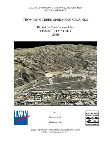
LEAGUE OF WOMEN VOTERS OF CLAREMONT AREAWATER TASK FORCETHOMPSON CREEK SPREADING GROUNDSReport on Conclusion of theFEASIBILITY STUDY2010byMarilee ScaffFebruary 2011League of Women Voters of the Claremont Area 2011P.O. Box 1532, Claremont, CA 91711
THOMPSON CREEK SPREADING GROUNDSREPORT ON CONCLUSION OF THE FEASIBILITY STUDYWhen the League of Women Voters (LWV) was founded in Pomona Valley in 1938, itsmembers immediately undertook a Know Your City study, concentrating on Claremont wheremost members lived. After that study, the LWV recommended that the City of Claremont buy itswater company. (Pomona, Upland, LaVerne already owned theirs.) The City decided to staywith that “nice little company” over in San Dimas. A number of times since, the LWV hasrepeated that recommendation—to no avail. In 2005 when there was again talk about negotiatingfor the City ownership of Southern California Water’s infrastructure and water rights, the LWVAnnual Meeting voted to establish a Water Task Force to study the question. Marilee Scaff wasappointed Chair. In December the Task Force issued the results of their study, Water Issues inClaremont, 2005, with Marilee Scaff and Freeman Allen as authors. This study undertook topresent precise and accurate facts without bias or point-of-view, presenting both pro-and-conarguments concerning the ownership of the water company. An anonymous League memberwith a long-time interest in water issues donated the cost of printing 1000 copies.Subsequent study by League members and Board led to discussions which considered thedesirability of public ownership, the lower cost of water in all our neighboring cities, the fact thatGolden State Water Company (GSWC) rates are now regional and recent applications to thePublic Utilities Commission make clear rates will continue to go up rapidly, the fact that GSWCnow prices their ownership very high and negotiations will almost surely require eminent domainproceedings, but that after about 12 years Claremont could begin to see slower rate increases.The chief negative point was the high cost of acquiring the water company. At the LWV Annualmeeting in June 2006, the members adopted a Water position which states:WATER Adopted 2006Support for policies, decisions, and practices that recognize clean and adequate water as essentialto human life. Support for public ownership of water rights and utilities as vital public resources to ensurethat public goals and purposes are reflected in policies and rates, including the prevention of any futureacquisition of water resources by any non-public agency, international cartel, or other private interest oroperation. Support for rate-setting based on actual costs of operation, with attention to economic fairness,taking into account costs of supplying water and quantity used, and recognizing, regardless of ownership,the inevitability of continued increases in water costs and ongoing maintenance expenses. Support forplanning, development, maintenance, and operation of the water system in the best interest of residents andenvironment, with attention to long range issues of sustainability: conservation, recycling and reuse,reduction of urban run-off, coordination of surface water and ground water supplies, and increased effortsto limit use of imported water. Support for public acquisition of the local water system, converting theprivately owned company to a city-owned water company by the use of public financing, believing thatpublic control is worth the cost, even if high, and has long-range advantages to rate-payers and to thecommunity.During the next year, Marilee Scaff and Freeman Allen, now Co-Chairs of the Water Task Force,made more than 20 presentation to local groups— all the local service clubs, Active Claremont,Sierra Club, Audubon society, church groups; in fact, wherever invited— explaining asimpartially as possible the pros-and-cons of water company ownership. Usually appearingtogether, occasionally alone, they passed out copies of the Water Issues booklet, explained issuesof buying the Golden State Water Company as Claremont’s local water purveyor, and answeredquestions. They sought consultations with Senior Management of major players in water1
delivery—City of Claremont, Three Valleys Municipal Water District, Golden State WaterCompany (since late 2005, the new name of former Southern California Water Company, now asubsidiary of American States Water, Inc.).During 2006-2007 the Water Task Force broadened their study to focus on an issue raised by thenew State Water Plan: how to reduce the need for imported water and increase local waterresources for greater long-range sustainability -- a major long range problem in Californiabecause of possible earthquake or other catastrophic damage to the levees of the SacramentoDelta and the delivery canals. We postulated that in Claremont we could reduce the need forimported water by increasing the yield of our Six Basins Aquifer through improved retention ofstorm water and local water spreading, with appropriate pumping of local wells to relieve theproblems of artesian water in Claremont and Pomona. After much discussion we decided not tofocus on the San Antonio Spreading Grounds in north Claremont, because of legal problems ofmining rights, actual gravel mining in pits on the San Bernardino County side, and the fact thatThree Valleys MWD was applying for aid for a Conjunctive Use Project there.We chose to concentrate on the Thompson Creek Spreading Grounds which records showed hadonly limited water spreading for the last 30 years. (See Fig. 1 below.)1710 & 1640 AF1267 & 1202 AF600500400Water Spread (AF)Annual Inflow (AF)Dam Outflow (AF)30020010001985 1988 1991 1994 1997 2000 2003Data from Los Angeles County Flood Control District and Three Valleys Municipal Water District.Fig. 1. Thompson Creek Spreading GroundsWater Inflow, Dam Outflow, and Water Spread 1985-2005.2
Our investigations and conversations led us to believe that use could be made of the old dam(built by LA County’s Flood Control District in 1932) to increase storm water storage, then thespreading grounds employed to improve the yield of the Six Basins Aquifer. This shouldincrease the supply of well water through the many wells spread throughout Pomona Valley.While saving storm water, the project could also restore four different kinds of biologicalhabitats and convert the land into a natural park with low-impact public access. A cordial visitwith L.A. County Supervisor Michael Antonovich sent us to the Los Angeles CountyDepartment of Public Works and its constituent Water Management Division (Flood Control).Engineers in the Water Division did not discourage us from moving ahead.Seeking sources of State bond money from Proposition 84, we attended workshops offered bythe Lower Los Angeles and San Gabriel Rivers and Mountains Conservancy (RMC). Weeks ofconcentration and planning resulted in an application to RMC for a grant entitled ThompsonCreek Spreading Grounds: acquire, restore, develop. We had promised the City of Claremontand fellow citizens that we would not seek either public or private funds from Claremonters,because they had just approved an ll.5 million local bond issue to buy Johnson’s Pasture andshould be considered as having already borne their fair share of the expense of saving privateland as open space. In November 2008 the RMC Board of Directors approved our applicationand offered to fund Phase I, a Feasibility Study, for 200,000. Because of state budgetconstraints, the actual start-up signal for work to begin was not given until February 2010.Meanwhile, the Water Task Force Co-Chairs had surveyed a list of ten possible consultants andchosen the firm of RBF Consultants to undertake this project. Larry McKinney, CEO of RBF,accompanied us on a tour of the TCSG. We were then put in contact with Ruth Villalobos andAaron Pfannenstiel of the Ontario office of RBF, and in several preliminary conversations gavethem copies of our conceptual plan for the future of the Thompson Creek Spreading Grounds(TCSG), shared relevant legal and geohydrologic records, and posed questions which we hopedthe study would answer. RBF prepared a Scope of Work to outline what they proposed to do inundertaking these tasks.The larger League Water Task Force, consisting at that time of Sandy Baldonado, Sally Seven,Jack Sullivan, and the current League President, served in an advisory capacity on all policydecisions. Contracts were negotiated and, when the signal to start work was given, contractswere signed with RMC and with RBF Consultants. Contracts specified a nine months Timelinefor completion of this Phase of the project, a contract price with RBF of 190,000, with 10,000reserved for LWV expenses on administration. Also an MOU was signed with Three ValleysMunicipal Water District, as Richard Hansen, CEO, had kindly offered Three Valleys MWD asour Fiscal agent, paying checks as submitted and waiting for State reimbursement—all at nocharge to LWV.Several years of working with all the significant partners and related agencies was an importantpart of this process. The City of Claremont agreed to add the land to its Claremont HillsWilderness Park, taking responsibility for liability, policing, and supervision of public access.Three Valleys Municipal Water District was willing to manage water aspects of the SpreadingGrounds. They have been especially helpful in the whole project, providing water records of theSpreading Grounds, and advising on water issues. Brian Bowcock, Three Valleys Boardmember from this District, has kept up with our progress, and seen that we were invited atvarious times to be guests for MWD tours of Diamond Lake and the State Water Project whichconveys water from the Feather River to Sacramento delta and on to Southern California. Three3
Valleys MWD treats and sells State Water delivered by the Rialto Feeder which runs underNorth Claremont. Los Angeles County was cooperative, from Supervisor Antonovich onthrough his staff and the engineers in the Department of Public Works and its WaterManagement Division (Flood Control District). Several professional staff members of RanchoSanta Ana Botanic Garden visited the site with us at various times, provided Herbarium lists ofplants collected in this specific canyon, found and identified endangered species, and offeredhelp with appropriate plants when the Project comes to that stage. Dean Coduto and members ofthe faculty in Civil Engineering at Cal Poly University-Pomona, instituted two senior studentseminars related to our Project: a possible water recycling plant and a watershed study. Personsfrom the City of Pomona and City of Upland were cordial and encouraging. Several facultymembers of the Claremont Colleges, leaders of Sustainable Claremont, plus League membersand citizens of Claremont and Pomona Valley, including several near neighbors of the project,all have been consulted and provided helpful community input and support as the project wentforward.Pomona Valley Protective Association (PVPA), owner of the land, and its constituentagencies, Golden State Water Company, Cities of Pomona and Upland, all have beenconsulted and were quite encouraging. Floyd Wicks, President and CEO of Golden States WaterCompany mentioned casually the possibility of partially gifting some of the land for a tax writeoff. PVPA, quite to our surprise, offered us 25,000 for assistance with planning if it werematched, and the Claremont City Council voted to match that amount if needed. (LWV in factnever held these agencies to those original offers.) Cecil McAlister, for 35-years the water gagemanager of the Spreading Grounds, kindly took various officials with us on many visits to seethe site. PVPA in their original letter to RMC offered “a conservation easement or some otherarrangement” for the land, but in August 2010 wrote a letter to RMC agreeing to be “a willingseller.” We continue in regular consultations with John Schatz, their attorney.The Feasibility Study – A Summary of FindingsThe Conceptual PlanThe League of Women Voters Water Task Force, led by Marilee Scaff and Freeman Allen, CoChairs, had developed a detailed Conceptual Plan for the projected use of Thompson CreekSpreading Grounds. First, a vision of increasing water retention through better use of the old damand the Six Basins Aquifer. Then restoration and regeneration of four types of habitats: AlluvialFan Sage Scrub, Riparian and Chaparral habitats, plus a newly installed wetlands to attracthillside animals and both resident and migratory birds. The Plan would require acquisition of thisland which immediately joins the Claremont Hills Wilderness Park, making it available to thepublic for low-impact recreation. Many aspects of the Thompson Creek Spreading Grounds sitewere taken into consideration: the lay of the land using photographs, maps, details on watersources, possible improved storage, need for water spreading, legal constraints, habitats bothrelatively undisturbed and in need of restoration, species threatened or endangered, possibleextension of biking and hiking trails, cooperation with partner agencies and local residents.Preparatory study included conversations with native Tongva tribe members in recognition oftheir ancient uses of this canyon. All this collected material was shared with RBF Consultants.The RBF team which undertook this study consisted of Aaron Pfannenstiel, Carolyn La Prada,and Pam Arifian. The team immediately used our ideas and, with flowers photographed on theThompson Creek site, designed a beautiful tri-fold brochure for public interpretative appeal.LWV had the brochures printed and circulated them widely in the community as outreach andinvitation to public involvement. (See Brochure, Page 5.)4
5
Research and AnalysisMany consultations took place between RBF staff and the LWV Water Task Force as the studygot underway, and continued as it progressed. RBF reviewed existing information, wrote,discussed, and finalized the Scope of Work, and began field reconnaissance and investigation.Feasibility Study - Summary of the Final ReportThe Feasibility Study Final Report opens with a summary of purpose and scope, the site,involved partners, and listing of existing conditions. Maps from Google, PVPA and other sourceswere consulted. A new map of Existing Conditions was developed by RBF to establish a baselinefor later options and decisions. A intriguing new Map was made from an airplane using GIS andcomputer-controlled radar to produce a superior Topographical Map, picturing in accurate detailthe precise elevations for planning of land use and habitat areas.Opportunities and ConstraintsOpportunities and Constraints Analysis was analyzed both on a Map and as text. Both delineateproject needs and existing conditions, some of which offer welcome advantages and some poseproblems to be resolved. Data include charts of actual water spread at TCSG, 1999 to 2009,notes about location adjacent to Claremont Hills Wilderness Park, analysis of surface geologyand watershed hydrology and the possibilities of groundwater recharge.Geohydrologic Site ConditionsOf special importance for this Feasibility study is a report, Geohydrologic Constraint Analysisfor Increasing Artificial Recharge in Thompson Creek, July 23, 2010, prepared by GeoScienceSupport Services, Inc. Details on surface geology, soil permeability, rainfall and surface waterinflow from the tributary creeks and the larger watershed assessed the potentials of theThompson Creek site for water spreading.Using comparative watershed analysis of Thompson Creek Spreading Grounds with spreading atLive Oak Dam, which is located immediately west of Thompson Creek Dam, and is comparablein area and rainfall, the hydrologists concluded that current long-term average artificial PVPArecharge of an average of 82 feet per year could be increased by 30 to 150 percent (30% to150%). They recommended the collection of site-specific data regarding percolation potentialand surface water inflows to provide a more accurate understanding of potential infiltration and amore accurate measure of actual recharge capacity. This would be accomplished by new gages tomeasure storm water inflow and two monitoring wells at the south edge of the property tomeasure effects on the aquifer. Monitoring wells would also indicate when more pumping fromwells would be needed to prevent water flowing to the surface in old cienegas in this nowheavily populated valley. These recommendations are incorporated into our final Map. (SeeMap, Preferred Concept Plan, at end of this Report.)First Public Meetings and Community InputEarly in the study process the RBF team designed and put on their website, linked to the LWVwebsite, a questionnaire and opinion survey about Thompson Creek SG to which anyone couldrespond. An invitation to participate in this survey was also on a sticker on the Brochuredescribed above. Tri-fold brochures were distributed at the City Hall, the local Library, and tovarious local groups or sites throughout the community. During Phase I of the Project RBF staffconducted two public meetings to present information and receive feedback at different stages ofthe Project development.The first Public Meeting was held on April 24, 2010 at the Hughes Community Center andattended by a count of 110 persons representing a wide range of backgrounds and interests. All6
public and private agencies which we had contacted were present, along with League members,residents of the neighborhood and other Claremont residents, as well as residents from all overthe Valley. Fewer than half were League members. LWV provided a free simple luncheon.RBF prepared a presentation and project overview. Then a group of tasks to encourage activeparticipation began with hand-held tabulators recording answers to a slightly modified version ofthe above-mentioned questionnaire. Immediate tabulation of results created interest among theaudience. Post-it notes identifying “Treasures”, “Challenges”, or “Visions” were next written byall participants and collected by six Cal Poly graduate students in Landscape Architecture whoposted them under each category. These ideas were read quickly for all to hear. In the thirdactivity people gathered in small groups (of 6 -8 people at each table) who, after discussion,wrote their Vision priorities for Thompson Creek Spreading Grounds. Each group sent oneperson forward to share their Vision statement. Cards on each table invited further comments.All the ideas were assembled by RBF and recorded in an interesting report of this meeting.Significantly, there was wide general agreement that this land must be kept in as natural a stateas possible, preserved in perpetuity for water spreading and open space with low impact publicaccess. This input clarified our original project name, and resulted in changing the title from“acquire, restore and develop” to “acquire, restore and preserve.”Following the meeting and public input, RBF prepared an Opportunities and ConstraintsAnalysis, which became the subject of subsequent discussion and decisions. These includedreview of past records of water spreading, records of ground water recharge, and all thehydrologic material summarized in this report.L.A. County Flood Control and Its EasementsContact with L.A. County Department of Public Works, Division of Water Management (FloodControl), was essential in clarifying critical water issues. Flood Control holds a number ofeasements on Thompson Creek land in addition to the land beneath the dam. Most of the landabove the dam is an easement for flood control after winter rains, for removal of debris and foroccasional removal of the silt which turbulent storm water deposits in the reservoir. County alsotakes responsibility for the safety of the dam, and after a careful study in 1996 completed areport, Evaluation of Seismic Stability of Thompson Creek Dam. Recommended seismicmodifications were completed in November 2001 at a cost of 2.2 million, and in cooperationwith CA Department of Fish and Game, a revegetation project on the disturbed area wascompleted in January 2009 at a cost of an additional 275,000. Keith Lilley, Senior CivilEngineer, and other engineers of DPW Division of Water Management, provided much technicalinformation to both LWV and RBF. The capacity of the reservoir, elevations determiningreservoir size, and maximum area which might be reached by a “100 year flood,” all aredelineated by contour lines on the final Preferred Concept Map (at the end of this Report).Biological Field StudiesDr. Thomas McGill, field biologist for RBF, conducted studies in the field and reported that thesite contains 70 acres of Riversidean Alluvial Fan Sage Scrub (RAFSS), a remnant of the state’s“most threatened” habitat. His recommendation is to improve the quality of this habitat andrestore its more varied bio-diversity by hand-thinning some of the present Mature stage toIntermediate or Pioneer stage RAFSS. Accomplishing this would involve sheet flow of stormwater across the alluvial fan, using this larger area for water spreading which more nearlyreproduces the pre-dam natural water flow and would regenerate a richer RAFSS habitat.7
Dr. McGill also identified Populus fremontii (Fremont Cottonwood) in Burbank Canyon whichdrains into the reservoir from the west, a fact which supports our concept of reestablishing agrove of Cottonwood trees at the foot of the cliffs in the riparian area northwest of the dam.Additionally, Dr. Lucinda McDade, Research Director, and conservation botanist Naomi Fraga,of Rancho Santa Ana Botanic Garden (RSABG), identified Chorizanthe Parryi, (Hairy spineflower) and Berberis Nevinii (Nevin’s Barberry), both classified as threatened or endangeredspecies, on the RAFSS area on the northeast corner of the property. They also printed for us theRSABG-Pom Herbarium list of all plants collected in Thompson Creek dam area from 1922 to1938. That list, they pointed out, shows that a number of Oak species, including Quercusengelmanii and Q. durata gabrielensis, now listed as threatened species, once existed here. OurFeasibility Study recommends that the RAFSS in the northeast corner should be left as MatureRAFSS, undisturbed, to protect these identified threatened species. Reestablishing a grove ofEngelmann Oaks in the disturbed land near the west entrance to the TCSG is part of ourconceptual plan for habitat restoration.Interpretive Element: Importance of Thompson Creek to Tongva Native AmericansMark Frank Acuña welcomed our request for interpretive material presenting the historicalpresence of the Tongva people in this Valley, and the importance to the Tongva people of theThompson Creek area. He responded with a short essay, The Place Below Snowy Mountain.Marilee Scaff worked with him in editing this material and soliciting illustrations, primarilyphotographs taken at the Tongva village site at Rancho Santa Ana Botanic Garden by JeanRosewall, RSABG Volunteer. Acuña’s essay appears as the Preface to the Feasibility Study.Because it seemed an important interpretive and outreach document, LWV contracted for 1200copies for public distribution. Already anthropologists (e.g. at Pomona College and the BowerMuseum in Santa Ana) have welcomed it. Others interested in California native tribes,ethnobotanists, cultural history buffs, and volunteers showing visitors through native gardensread it with delight. There has been very little written material available about the Tongvapeople. A copy of The Place Below Snowy Mountain is attached inside the back cover.Alternative Concepts and Community OutreachFollowing the collection of all the above input, alternative conceptual designs were developedthrough careful consideration by RBF planners, engineers, biologists, regulatory specialists andthe League of Women Voters representatives. Based on the Opportunities and ConstraintsAnalysis and associated technical studies, three alternative concepts were developed to meet theproject goals and the grant criteria of RMC. Starting from a map of Existing Conditions, in theplan formulation stage RBF created three additional alternate maps, Options A, B, and C for apossible future Plan for Thompson Creek Spreading Grounds.Second Public Meeting Considers OptionsOn September 25, 2010 the second public meeting featured copies of these four maps plus abeautiful pictorial representation of habitats decorating the walls of the meeting room, attractingstudy and conversation from groups as they arrived. Additional smaller copies were available onall the tables around which participants were seated. About 70 representatives of League and thecommunity gathered for an update on the outcomes of the Feasibility study and expression ofpreferences among the Options offered. Again, all our partnering agencies and groups wererepresented, including five persons from the PVPA and Dennis Bertone of the RMC Board. Aftera Power Point presentation there were questions and discussion. Post-it notes written byparticipants were placed on each of the big Option boards. Cards for written comments invitedall to express opinions or make suggestions. All questions were recorded and addressed both onthe floor and in the final report.8
At this meeting there was general agreement about desirable points from each of the three plans.Responders favored plans for improved water spreading including sheet flow over some of theRAFSS, new gages and monitoring wells as indicated, habitat restoration, location of possiblewetlands and a connection for using reclaimed water if that becomes available. Participants likedlow-impact recreation via paths for walkers, preferred bicycles to be limited on paths throughnatural areas, but wanted a path for bikers and walkers parallel to Mills Avenue connecting theRegional Bike Trail to Claremont Hills Wilderness Park trails. More parking along Mills Avenuewas considered needed. Respondents recognized L.A. County Flood Control’s responsibilitiesand accepted fencing off reservoir borders in case of unusually heavy rainfall, but hoped forcooperation of flood control with habitat restoration. All confirmed the need for City ownershipand preservation of the land. Three Valleys MWD was thanked for its encouragement and helpwith fiscal management now and water spreading management later.Feasibility Study CompletedBased on community input and technical analyses, the Feasibility Study as formulated by RBFincludes the required elements to achieve the LWV’s project goals while working withinconstraints of the property and the surrounding environs. Addenda attached to the Final Reportinclude: the original Grant application, RMC’s Exhibit D, a Land Acquisition applicationprepared for CA Fish and Game, City’s Land Use and Bicycle Plans, and various analyticaldocuments and technical reports prepared as part of the study. The League of Women Voters wasprovided a draft copy on December 10, which was carefully read by Marilee Scaff, who offeredsome readjustments of organization and text, and small editorial corrections in preparation for afinal discussion between LWV and RBF staff.The conclusion of the Feasibility Study states priorities for development in five areas, theaccomplishment of these depending primarily on funding, with elements numbered 1 (highestpriority), 2, or 3. Accomplishing items numbered 1 is deemed necessary for the project to meetthe grant criteria and goals of the LWV. Abridged, they are:Water:1. As much spreading as possible --sheetflow with stormwater on land south of the Dam andsouth of the TC Channel Trail2. Gages and Monitoring wells as specified3. Potential wetlands using recycled water.Habitat:1. Preserve Riversidean Alluvial Fan Sage Scrub (RAFSS)2. Plant groves of native cottonwood and oak trees in appropriate zones.2. Incorporate wetlands for wildlife and migratory birds.3. Restore riparian habitat in Burbank Canyon and around creekside as possible.Recreation:1. Include loop trails throughout site, minimizing habitat impacts.2. Connect existing Thompson Creek Trail with CHWP along Mills.Education:1. Provide non-intrusive exhibits on history, geology, hydrology, and Tongva people;signage blending with natural elements2. Include large Tongva acorn-pounding stone with signage.Legal:Work to see site acquired and in public hands.The Preferred Concept Plan concludes with the Map and Summary of Concept Elementswhich appears at the end of this Report.9
As contracted, five complete copies of the Feasibility Study with Addenda, and an additional 10copies of the major report with discs of the complete copy were provided to LWV on December22. One copy of the Final Report plus one of the major report with disc were delivered to RMCon December 28, 2010. (Heavy rains closed the RMC Office in this interim.) RBF has alsoprovided the League with large poster boards of the Options, Habitats, Topographical Map, andFinal Preferred Plan and extra copies of the disc.Of the five complete Feasibility Study copies: one has gone to RMC, one to City of Claremont,one to Three Valleys MWD, and one for League files. The remaining copy is held for possibleuse in another grant application. PVPA has been given one of the shorter ones with a disc of thecomplete study. Involved or interested Partners may have discs as needed.Land AppraisalThe League team had met on November 10, 2010 with RMC staff to go over final steps of theFeasibility Study. Jane Beesley, Deputy Executive Officer of the Watershed ConservationAuthority and Valorie Shatynski, Deputy Executive Officer and our Project Manager at RMC,urged us to include a land Appraisal of the Thompson Creek site, using funds from our LWVAdministration Budget. RMC provided two names of appraisers. After talking with both, wecontracted with Thomas Erickson, an appraiser with 32-years experience in the San Gabrielfoothills, who agreed to a 45-day timeline and 3,50
Thompson Creek Spreading Grounds Water Inflow, Dam Outflow, and Water Spread 1985-2005. 2. 3 Our investigations and conversations led us to believe that use could be made of the old dam (built by LA County's Flood Control District in 1932) to increase storm water storage, then the