Transcription
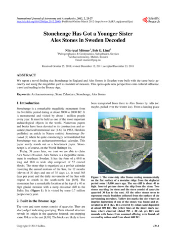
International Journal of Astronomy and Astrophysics, 2012, 2, 23-27http://dx.doi.org/10.4236/ijaa.2012.21004 Published Online March 2012 (http://www.SciRP.org/journal/ijaa)23Stonehenge Has Got a Younger SisterAles Stones in Sweden DecodedNils-Axel Mörner1, Bob G. Lind21Paleogeophysics & Geodynamics, Saltsjöbaden, Sweden2Archaeoastronomy, Malmö, SwedenEmail: morner@pog.nuReceived October 25, 2011; revised December 12, 2011; accepted December 23, 2011ABSTRACTWe report a novel finding that Stonehenge in England and Ales Stones in Sweden were built with the same basic geometry and using the megalithic yard as standard of measure. This opens quite new perspectives into cultural influence,travel and trading in the Bronze Age.Keywords: Archaeoastronomy; Stone Calendars; Stonehenge; Ales Stones1. IntroductionStonehenge is a remarkable megalithic monument fromthe Neolithic period dating at about 3000 to 2000 BC. Itis monumental and visited by about 1 million peopleevery year. It must be held as one of the most importantarchaeological objects in the world. Numerous papersand books have been devoted to its construction and assumed practical/ceremonial use [1-6]. In 1963, Hawkinspublished an article in Nature entitled Stonehenge Decoded [7] where he quite convincingly demonstrated thatStonehenge was an archaeoastronomical calendar. Thispaper surely stands out as a benchmark paper. Stonehenge is, of course, on the World Heritage list.Today, 38 years later, we trust we are able to claimAles Stones Decoded. Ales Stones is a megalithic monument in southeast Sweden. It has the form of a 69.8 mlong and 18.8 m wide ship composed of 57 erectedblocks. The stone-ship is organized as a perfect calendarrecording the annual motions of the Sun, the 12 months(eleven of 30 days and one of 35 days; i.e. in total 365days per year) and the daily movements of the Sun withrespect to zenith in the south-north line [8,9]. Themonument has a remarkable location at the top of a 40 mhigh glacial moraine with a steep erosional cliff to theBaltic Sea (Figure 1). It is visited by some 0.7 millionpeople every year.2. Built in the Bronze AgeThe stem and stern stones consist of quartzite. They aresharp-edged indicating quarrying. Their internal structurereveals its origin in the quartzite bedrock out-croppingsome 30 km to the east [8,10]. The blocks are likely to haveCopyright 2012 SciRes.been transported from there to Ales Stones by rafts (or,maybe, pulled over the winter ice). From a landing placeFigure 1. The stone-ship Ales Stones resting monumentallyon the flat surface of a moraine ridge from the deglacialperiod some 13,000 years ago. The sea cliff is about 40 mhigh. Inserted picture shows the ship from the stern. Twostones marking the stem and the stern consist of quartzitequarried 30 km to the east. All the other stones seem torepresent erratic boulders collected from the surface of thesurrounding moraines. Yellow dot marks the site where animprint depression of one of the stones was found and excavated in 2011 [12]. It is covered by eolian sand depositedat about 600 BC. The yellow lines at the shore mark sections where charcoal (dated 785 20 cal. yrs BC) andmounds with bones from assumed offering were found, allcovered by eolian sand from about 600 BC.IJAA
24N.-A. MÖRNERat the foot of the cliff, the stones were then pulled up tothe site of erection in the stem and stern of the ship. Atthe proposed landing place, there is a buried land surfacewith lots of bones (primarily of pigs, especially youngpigs) and charcoal, radiocarbon dated at 785 20 cal. yrsBC [8]. The surface is covered by eolian sand depositedat around 600 BC. Between this landing point and thestern stone, there are traces of a buried transportationway [8,11]. Here, too, the old land surface is covered byeolian sand deposited 600 BC.All the other 55 stones in Ales Stones seem to be erratic boulders collected from the surface of the old glacial and late glacial deposits in the surroundings [10], notleast the moraine ridge itself. Some of the stones showsigns of severe wind erosion typical for the pre-glaciallandscape. This summer, we excavated the imprint in thetill surface of a huge block. The block was about 3.2 1.2 0.5 m. One of the stones in Ales Stones (60 m away)seems to fit quite well into the imprint hollow. The oldtill surface and the imprint hollow are now covered byeolian sand deposited 600 BC. Consequently, the removal of the block, the transportation away and erectionin Ales Stones must pre-date the wind blown sand at 600BC [12]. There- fore, we conclude that Ales Stones wereerected in the late Bronze Age (or earlier, but not later).The individual stones in Ales Stones are full of cupmarks, a favourite object in Scandinavian rock-carvingfrom the Bronze Age (but also occurring in the Neolithicand Early Iron Age). Most important are the cup markson the top of stone 8 from the stem stone and stone 8from the stern stone (Figure 2) because they exhibit perfect solar alignments [8,9]. Therefore, they must havebeen cut into the tops of those two stones when thestones were erected and in place; i.e. in the late BronzeFigure 2. Ales Stones with the alignments (blue arrows) of thesunrise and sunset at Winter and Summer solstice. On thetop of stones 8 in the NW and the SE, there are cup marks,which exhibit strict alignments to the solar motions [8]. Thefour number 8 stones form a rectangle marked in yellow.Copyright 2012 SciRes.ET AL.Age at around 700- 800 BC (cf. below).3. Function and Basic GeometryAles Stones is built so that, seen from the centre, the Sunrises over the stern stone at Winter solstice and sets overthe stem stone at Summer solstice. The Sun rises atSummer solstice between the two stones marking themid-ship in NE and sets at Winter solstice between theopposite stones in SW. Similarly, the Sun rise and Sunset at equinoxes occur over the 12th stones marking theE-W alignment. All the main six solar events are recorded in Figure 3. The alignments recorded can, ofcourse, not be a mere coincidence. It must be the result ofa careful planning. The cup marks on stones 8 in the westand the east (Figure 2) give the same alignments. Thislends strong support for an interpretation in terms of anancient calendar.The stone arrangements also provides a record of themonths, all of 30 days except for the 7th month that had35 days, making a total year of 365 days [8]. Sun risesover the stern stone on December 24 (Winter solstice) at08.34, over stone 3 on January 23 at 08.15, over stone 9on February 22 at 07.15, over stone 12 on March 24 at06.00, over stone 14 on April 23 at 04.40, over stone 15on May 23 at 03.42 and over stone 16 on June 22 (Summer solstice) at 03.20. Sun sets over the stem stone onJune 22 (Summer solstice) at 20.48, over stone 3 on JulyFigure 3. Ales Stones (with reconstructed shape at the stem;cf. Figure 2) and its very strict alignments with respect tothe sunrise at Winter solstice, Spring equinox, Summersolstice and Autumn equinox, and the sunset at Winter solstice, Spring equinox, Summer solstice and Autumn equinox. There is a minor deviation of 38.5 cm or 0.77 withrespect to the strict NW-SE symmetry axis. This is consistent with an age of construction of around 700 BC [8].IJAA
N.-A. MÖRNER27 at 20.15, over stone 9 on August 26 at 19.15, overstone 12 on September 25 at 18.00, over stone 14 on October 25 at 16.40, over stone 15 on November 24 at15.42 and over stone 16 on December 24 (Winter solstice)at 15.30. Every single step is recorded by photos takenfrom the centre of the ship [8]. This can hardly be understood in other terms than a carefully planned calendar.The daily motion of the Sun is recorded by 16 stones,each one of which represents 1.5 hours. A pole in thecentre inclined at 30 to the north gives a shadow passingfrom stone to stone at an interval of 1.5 hours [8].The alignments are very exact (Figure 3). There is asmall deviation, however. The Sun rises at Winter solstice about 38.5 cm or 0.77 east of the centre of the sternstone, and Sun sets at Summer solstice about 38.5 cm or0.77 west of the centre of the stem stone. This discrepancy is caused by the long-term changes of the tilt ofEarth’s rota- tional axis. Converted to time, this deviationimplies an age of the construction of the calendar ofabout 700 BC [8], an age that fits perfectly well with ourstratigraphical records indicating that the stones weretaken out of the ground and placed in the ship shortlybefore the sand drift at 600 BC [8,11,12].A recent finding is that the standard of measure in association with Ales Stones seem to fit with the Megalithic Yard (MY) [9]. This standard of measure was usedall over the British Islands during the Neolithic andBronze Age [13].The form of a ship is, of course, the most basic shapeof the Ales Stone monument. One may, however, alsoidentify some other basic geometric signs. They are: 1) arectangle of the 4 stones termed stones 8 (from the stemand the stern, respectively), two of which have specialcup mark figures on their tops (Figure 2); 2) a circlethrough the corners of the before mentioned rectangleand the stones off the mid-ship alignments of the Sun riseat Summer solstice and Sun set at Winter solstice; and 3)the alignment of the Sun rise at Summer solstice (Figure4). We use these 3 geometric signs in a comparison withthe same basic geometry of the Stonehenge monument.ET AL.25Figure 4. Besides the form of a ship, Ales Stones has a basicgeometry consisting of a rectangle (yellow), a circle (pink)and the line of the first sunbeam at Summer solstice (redarrow). The length of the ship, the sides of the rectangle andthe diameter of the circle suggests that the standard ofmeasure was the Megalithic Yard [9,13].Figure 5. The original drawing of Stonehenge by Hawkins[7] can be simplified by 3 basic elements; the rectangle (ofthe Station stones), the Aubrey circle and the line of thefirst sunbeam at Summer solstice. The figure is a sketch,however, not drawn to a fixed scale.4. Comparison with StonehengeThe original plan of Stonehenge given by Hawkins [7],includes 3 basic geometric factors: 1) the rectangleformed by the station stones; 2) the circle of the AubreyHoles; and 3) the line of the first sunbeams at the Summer sol- stice (Figure 5). This is an important record ofthe basic geometry behind Stonehenge. The problem,however, is that the figure is not drawn to a fixed scale;rather it is a sketch expressing the basic principles [7].In Figure 6, the monument is drawn in its correct proportions [3]. We have marked the basic three elements; 1)the rectangle of the station stones; 2) the circle of theAubrey Holes; and 3) the sightline of the first Sun beamsCopyright 2012 SciRes.Figure 6. Stonehenge as drawn to a strict scale with its 3basic elements marked; the rectangle (yellow), the circle (pink)and the alignment to the sunrise at Summer solstice (redarrow).IJAA
26N.-A. MÖRNERET AL.Sun rise atSmmerSolsticeat Summer solstice. This implies that both Stonehenge(Figure 6) and Ales Stones (Figure 4) seem to be builtwith the same basic geometry.In Figure 7, we have made the 3 basic geometric parameters of Stonehenge (Figure 6) transparent, and superposed it on Figure 4 of Ales Stones. The agreement isstriking: the two rectangles have almost the same proportions, the two circles overlap perfectly well, and thealignment of the first Sun beams at Summer solstice isidentical. This can hardly be a coincidence. Rather doesit seem to indicate that both monuments were built afterthe same basic geometric principle. This may sound astonishing because of geographic distance and differencein time. It can be taken as new facts pointing to quiteanother cultural interchange between Britain and Scandinavia than generally realized.Other facts point in the same direction. “The boy withthe amber necklace,” buried at Boscombe Down, 5 kmSE of Stonehenge, and dated at 1550 BC bear witness oftravel and cultural interchange [14-16]. The isotopiccomposition of his milk teeth is indicative a childhood inthe Mediterranean. The 90 amber beads in his necklacehave a provenance from the south Baltic coasts. Thisprovides evidence of long-distance migration and trading.The southeast part of Sweden may even have been somesort of trading centre [17-19].The similarity in basic geometry of Stonehenge andAles Stones and the application of the megalithic yard asa standard of measure at both sites provide quite strongarguments for a cultural connection, including migrationand trading, between Britain and Southern Scandinaviain the Bronze Age.Figure 7. Superposition of Stonehenge (Figure 6; transparent) on top of Ales Stones (Figure 4). The 3 basic geometricelements the rectangle, the circle and the Summer solsticealignment are almost identical. This cannot be a mere coincidence. Rather does it seem to indicate that both monuments were built after the same basic concept. This wouldimply that there was quite another cultural exchange in theBronze Age than generally assumed. It fits, however, withnew findings in England [14-16] and Sweden [8,17-19].5. ConclusionsIn 1963, Hawkins presented his bench-mark paper entitled “Stonehenge decoded” [7]. We are now able the saythe same about Ales Stones. Obviously, it was built as asophisticated calendar. The stone ship of Ales Stones waserected in the late Bronze Age, judging from multipleconverging age determinations [8,11,12].A novel finding, not previously presented, is thatStonehenge and Ales Stones are built with the same basicgeometry. Furthermore, the standard of measure is themegalithic yard in both monuments.Obviously, Britain and southern Scandinavia werelinked by cultural influences, travel and trading in theBronze Age.Stonehenge belongs to the Neolithic period and AlesStones to the late Bronze Age. The geometric linkage ofthe two monuments (Figure 7) reveals an influence fromBritain to southern Sweden. One may say: “Stonehengehas got a younger sister—but so much more beautiful”.Finally, we find Ales Stones so remarkable both inbeauty and in scientific value that it deserves to becomeCopyright 2012 SciRes.incorporated on the World Heritage list.REFERENCES[1]G. S. Hawkins, “Stonehenge Decoded,” Souvenir Press,Cambridge, 1966.[2]Ch. Chippindale, “Stonehenge Complete,” Thames &Hudson and Ithaca, London, 1983.[3]R. J. C. Atkinson, “Stonehenge and Neighbouring Monuments,” English Heritage, London, 1993.[4]D. Souden, “Stonehenge, Mysteries of the Stones andLandscape,” English Heritage, London, 1997.[5]R. Heath, “Stonehenge,” Wooden Books Ltd., London,2001.[6]C. Nutt, “The Stonehenge Story,” English Heritage, London, 2004.[7]G. S. Hawkins, “Stonehenge Decoded,” Nature, Vol. 200,1963, pp. 306-308. doi:10.1038/200306a0[8]B. G. Lind and N.-A. Mörner, “Mykenska och Fenisiskaspår på Österlen,” Stjärnljusets Förlag, Malmö, 2010.[9]B. G. Lind and N.-A. Mörner, “Kopplingen StonehengeAles Stenar (Summary: Stonehenge-Ales Stenar: Builtwith the Same Basic Geometry and with the MegalithicYard as Standard),” Stiärnljusets Förlag, Malmö, 2011.[10] J. Bergström, E. Daniel, E. Herner, K.-E. Kornfält, M.Strömberg and H. Wikman, “Ales Stenar-Stenarnas Historia,” Ale, Historisk Tidskrift för Skåne, Vol. 4, 1988, pp.1-13.[11] P. Wikström, “Arkeologiska Undersökningar Med Markradar vid Ales Stenar,” Radarteam AB, Rapport 10-901,2010, pp. 1-12.[12] N.-A. Mörner, “Geological Investigations,” Report to theSwedish Board of Antiquity on the excavation at AlesStenar in 2011, Part 2, pp. 1-24 (in Swedish).IJAA
N.-A. MÖRNER[13] A. Thom and A. Burl, “Stones and Standing Stones: Britain, Ireland and Brittany,” Oxford, 1990.[14] J. A. Evens, C. A. Chenary and A. P. Fitzpatrick, “BronzeAge Childhood Migration of Individuals near Stonehenge,Revealed by Strontium and Oxygen Isotope Tooth Enamel Analysis,” Archaeometry, Vol. 48, No. 2, 2006, pp.309-321. doi:10.1111/j.1475-4754.2006.00258.x[15] J. A. Evens, J. Montgomery, G. Wildman and N. Boulton,“Spatial Variations in Biosphere 87Sr/86Sr in Britain,”Journal Geological Society, Vol. 167, No. 1, 2010, pp. 14. doi:10.1144/0016-76492009-090[16] J. A. Evens, “Stonehenge Boy Was from the Mediterranean (2010), The boy with Amber Necklace: Bronze AgeTeenager Buried at Stonehenge Had Travelled to VisitSite from the Mediterranean,”Copyright 2012 SciRes.ET [17] N.-A. Mörner, B. G. Lind and G. Possnert, “Heimdall’sStones at Vitemölla in SE Sweden and the Chronologyand Stratigraphy of the Surroundings,” Geografiska Annaler, Vol. 91A, No. 3, 2009, pp. 205-213.[18] N.-A. Mörner and B. G. Lind, “Mediterranean BronzeAge trading centre in SE,” In: S. P. Paraminopoulos, Ed.,The Atlantis Hypothesis-Commentary 2008, HeliotoposPubl., Athens, 2010.[19] N.-A. Mörner and B. G. Lind, “Long-Distance Travel andTrading in the Bronze Age,” Atlantis 2011, 3rd International Conference, Santorini, 25-26 June 2011, 4 Pages.(Also: In: S. P. Paraminopoulos, Ed., The Atlantis Hypothesis-Commentary 2011, Heliotopos Publ., Athens,2012, in Press).IJAA
Email: morner@pog.nu . Received October 25, 2011; revised December 12, 2011; accepted December 23, 2011. . maybe, pulled over the winter ice). From a landing place . Figure 1. The stone-ship Ales Stones resting monumentally . tent with an age of construction of around 700 BC [8].