Transcription
RE-CONNECTING SPACESThe Urbanization of Greenbriar MallA design project by Keith Brockman
Master’s Project ReportThesis Statement:Thesis Abstract:The suburban spaces we live in today have developed in a pattern which focuses on supporting our technological advances as opposed to focusing on our communities. This in turn has resulted in spaces whichdo more to isolate people from one another; separating them by vast distances and often unmanageable conditions. A response is needed which reconfigures these spaces and repurposes them in order toprovide places where people can reconnect with their neighbors and the regions they inhabit on a morehumane level.“A number of recent American writings indicate that the nostalgia for the small town need not be constructed as directed toward the town itself: it is rather a “quest for community” – a nostalgia for a compassable and integral living unit. The critical question is not whether the small town can be rehabilitatedin the image of its earlier strength and growth, but whether American life will be able to evolve and otherintegral community to replace it.”Max LernerAmerica as a Civilization 1957Critical Positions Statement:There is an epidemic in the United States of communities, families, and individuals being isolated fromeach other and there are many factors which have lead to this. Our lives are busier than ever filled withwork and extracurricular activities which are in locations that are isolated from one another be they domestic, employment, recreational, or just social. These busy schedules keep us constantly on the move and inour current built environment further isolated from one another due to the vast distances between activitiesand the routes we must take to get there. Single uses take up vast swathes of land and many of our streetsin suburban areas especially have developed in dendridic patterns which funnel vehicles into arterials thatare often remotely located from one’s ultimate destination. This pattern of development takes up more ofour time with travel, isolates individuals from one another, and needlessly consumes vast resources. I believe our built environments need to be reorganized into a more socially integrated mix of uses and spacesthat keep us in closer connection with one another.Not until recently and for decades before it has been common zoning and planning practice to isolateuses from one another so that there are large pockets of commercial uses separated from residential andindustrial uses, and unless you lived in a metropolitan or sometimes historic downtown distract there wasnever any mixing of uses. This development practice has lead to a dependence on the automobile fortransportation which further isolates individuals from one another. Each automobile acts like an isolationtank depriving the occupant of their senses of the environment around them and further isolating them fromtheir neighbors and communities.It is my belief that in order to reconnect with our surroundings and each other a more integrated approachto the design of our environments is necessary. Instead of each discipline working on their own separatepart of a project and not worrying about if it is the best solution for the problem we must reconnect withour counterparts in order to create efficient solutions for our future. We will get the perspectives of our colleagues and they ours getting the benefit of our each other’s unique training and knowledge so that moredynamic solutions can be found for the problems we face in an ever growing population with diminishingresources.This is only a first step though, we also need to create more dynamic spaces where the uses are mixed andpedestrian friendly to reduce our reliance on automobiles and get us out into the environments we live in.We need to once again become actively engaged in the places we live. A good mix of uses is not enoughthough, there must also be spaces designed to become third places. These locations are outside work andthe home and give us ways to more deeply engage those we share our communities with.Instead of focusing internally on individual properties and their uses we must take a more external approach to the design of our environments. The day of the single purpose structure isolated in a gray fieldof parking which can only be accessed by an automobile are over, It is my belief that we need a moreintegrated network of transportation and public community spaces that support one another and seek toconnect the spaces in which we live offering a chance for interaction between the inhabitance.In examining this thesis I have focused my project on retrofitting the existing Greenbriar Mall shoppingcenter which was the third enclosed shopping center in Atlanta, George and is located in Atlanta’s southwest region at the intersection of Interstate 285 and Langford Parkway. This location gives the shoppingcenter the possibility of regional access but due to a greater emphasis on the movement of automobilesalong with providing exorbitant amounts parking rather than a focus on connectivity and pedestrianmovement it has resulted in its lack of visibility and being almost inaccessible to these major thoroughfares of the region as well as the surrounding neighborhoods. This shopping center provides a greatexample of common development patterns that have resulted in a disconnect between the individual andtheir community.I propose to as a solution to this disconnect developing an integrated system of transportation optionson a new more connected urban grid. This grid will have a greater focus on the pedestrian and walkability. The new framework will also create an entertainment area which incorporates a series of plazasand public spaces that connect the system together offering a chance for individuals to reintegrate themselves back into their communities to reconnect with each other and their region.
Master’s Project ReportDesign Project:The intent of this project is to take an existing suburban shopping mall which is isolated from the surrounding infrastructure due to a poorly integrated suburban fabric and an over exaggeration of the parking requirements needed to serve the location, and retrofit it into a more sustainable and communityoriented urban environment.The current site consists of one main building which serves as the main impetus for the entire site, andalthough it boasts a ninety five percent occupancy rate it continually suffers from a lack of connectivity tothe surrounding communities and region. In order to compensate there have been numerous attemptsto lease potions of the outlying property for other uses such as a movie theater, grocery store, and several restaurants thinking this could increase the regional draw to the site as well as result in a sharing ofcustomers, but only ends up in struggling and abandoned structures around the principle use. This project seeks to resolve these issues by first imposing a new urban grid over the property which will make ita more developable site and a more manageable environment for pedestrians to navigate increasing theconnectivity of the site to surrounding communities and the region. In an effort to further increase regional connectivity to the site a new street car station is being introduced that will tie back into the existingmass transit system. Finally a new system of special public streets and plazas are introduced to createan environment which promotes community interaction through the framework of an entertainment district located between the existing mall and new transit station. All these elements seek to support the malland focus on it as a nexus around which community can happen.The urban plan forms the backbone of the project creating a network of streets which have the pedestrian in mind incorporating wide sidewalks with trees and street parking lining all the streets. All of the mainthoroughfares surrounding the site except the interstate are scaled down in order to slow traffic down andallow pedestrians to enter the site without having to worry about making it across the street before thelight changes allowing them to no longer function as dames to movement. This was particularly importantin this area as a vast portion of the community gets around on foot or by public transportation. All thestreets internally to the site are also scaled down with strategically located bike paths. Additionally thestreet network breaks the super block down into a more manageable and developable series of blockswhich range in size from two hundred and fifty feet by five hundred and fifty feet to a smaller three hundred by three hundred foot block. These block sizes are important as they offer a great flexibility in development and parking options for the whole site. This restriction in block size also allowed for the additionof two streets which divided the mall into three parts opening up the existing internal plazas to the publicas well as preparing the site of the mall for possible redevelopment in the future if the mall should not bea desirable building type at that time.The scaling down of the freeway to the North as well as the integration of a new street car transit stationis the key to reintegrating the site back into the region. Regional access previously was from one freewayoff ramp which was poorly integrated into the site offering limited visibility to the site or any indication ofits amenities. By turning the freeway into an at grade commercial main street it offered the opportunity toconnect to neighborhoods across the street by both automobile and pedestrian traffic as well as increasing the permeability of the site. The at-grade street design also allows for the introduction of a new streetcar to the site serving a greater need to this community of connectivity to the broader metropolitan areathrough an expanded mass transit system. In addition the Street car also brings a new demographic tothe shopping center.Not only does the new transit station integrate the site into the regional transportation and communitynetwork but it also serves as the main gateway to a series of plazas and public spaces that will form thenew entertainment district. The entertainment thoroughfare is designed to create an area where community can happen. This street is designed primarily for the pedestrian separating people from the isolatedenvironments of their cars and offering them the opportunity to interact with one another. Automobiletraffic it discourages through the use of narrow one lane traffic in both directions and limited access toparking from this street. There are broad sidewalks to either side with a central kiosk lined pedestrianwalk connecting the transit station to the new centrally located mall plaza. These kiosks will offer twoservices. The first is to replace some of the retail which will be lost at the mall itself due to the additionof cut through streets and a central plaza. This will allow the mal to reach out to the transit station as ifthe shopping simply transitions from indoors to outdoors. The second function the kiosks will server isa place for enlivening activity in this new public realm and not just resulting in a long corridor devoid ofactivity. They will offer opportunities for pause where people can begin to interact with one another. Thebuildings lining the street will also consist of a series of bars , restaurants, comedy, night clubs, and music venues completing the entertainment component of the street. Occasionally the street may be closeddown to automobile traffic and incorporated with the new central mall plaza to host large events or concerts of local and national musicians.The new central mall plaza though is the main community space. No longer with an emphasis on movement this place offers a refuge from the fast paced urban environment. Here people are enticed to sit andvisit or eat as the food court of the mall is integrated into the plaza offering outdoor seating which is bothshaded and sunlit throughout the day due to its complex north facing alignment. There are also spacesdesigned into the plaza acting as natural stages for two or three local performers or one larger function atthe southern end of the plaza. Other stage events can take place in the plaza as well. These may includepageants and community wellness events or even local premieres of the neighborhoods Tyler Perry Studios latest movie.I believe this project shows how through a combination of a multi-modal transportation network with integrated public spaces community can be fostered. Our communities can be reconnected to one another ifwe just take the time to eliminate some of the space with place.
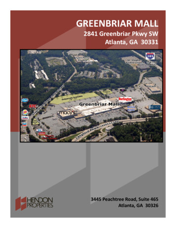
Site LocationGreenbriar Mall is part of the Atlanta Regional Commission’s (ARC) Greenbriar Mall LCI studyarea. The study area is located in South East Atlanta Georgia and comprised of approximately1.6 miles surrounding Greenbriar Mall. The Greenbriar Mall LCI study area is bounded by GilandRoad and Panther Road to the North, Barge Road on the West, Hogan Road the city limits, andTri-Cities area East Point on the East, and College Park and Hapeville on the South. There isstrong regional access via I-285 and Langford Parkway as well as global access given its proximityto Heartsfield International Airport, Site visibility and directionalsignage however are extremelypoor from I-285 and only slightly better from Langford Parkway. In addition to connecting thesite to the region though these arterial roadways effectively isolate the site into three distinctlyseparate quadrants, which are only able to be adequately accessed by automobile or bus transit.This has affected the sites ability to be a major retail area which can serve the region andsignificant to the local economy.
Site HistoryGreenbriar Mall was designed by John Portman and opened in 1965 as Atlanta’s third enclosedmall. The mall and surrounding out parcels occupy 90.71 acres of prime developable land whichis currently being underutilizd by vast amounts of impermeable surface parking. The mall properhas 113 stores which are 96 percent occupied and Macy’s and Burlington Coat Factory asanchor tenants on opposite ends of the long axis of the mall. Burlington Coat Factory is locatedon the less visible western end of the mall. This anchor location has traditionally suffered dueto its lack of visibility, starting out as a JCPenney’s from 1965-1985 then an Upton’s from 19871992. The more prominent anchor site is the eastern site which started out as a Rich’s when themall opened a recently changed ownership becoming a Macy’s. This location seems to havealways out performed its counterpart possibly due to its greater visibility, and while still underRich’s management signed a 10 year lease in 2001. The smaller tenant stores occupying thebody of the mall are a variety of lower quality brand stores with some better quality non-brandstores. There is even a waiting list for some of the smaller locations indicating at the health of thelocation itself. The out parcels which exist consist of some fast food dinning and an automotiveservice center in the north east corner of the site along with a Wachovia Bank in the south eastcorner of the site. These out parcels appear to preform better than there larger counterpartsto the west which consist of a sit down restaurant a Cub Foods and Magic Johnson Cinema,the only difference being the visibility of the locations. Cub Food’s closed in 2001 and remainsboarded up even though mall management has been trying to get a tenant for the location. MagicJohnson Cinema was anticipated to act as a third anchor for the mall, but due to the expansiveparking lots separating the them the theater had to support itself and again because of a lack ofvisibility ultimately closed its doors on October 11, 2009. A renewed interest has been taken inthe theater though and it is being renovated for reopening in the near future. The remainder ofthe site consists of 68 acres of under utilized surface parking offering 6000 spaces. Only 4000spaces are currently needed to support the malls current operations leaving 2000 spaces (20acres) which never get used. The topography of the site is also relatively flat and slopes mildlyfrom north west to south east.SiteArea: 90.71 acresUndeveloped: 11.97 acersBuilt: 16.78 acersParking: 68 acresUnused: 20 acresBoundariesNorth: Langford ParkwayEast: Greenbriar ParkwaySouth: Greenbriar ParkwayWest: I-285
Existing Conditions
Existing Conditions
RenderingsCampbelton Road TADKey Concepts:- Seeks to increase economic development potential and connect surrounding neighborhoods.- Route for new proposed mixed-flow light rail trolly connecting Greenbriar to Greater Atlanta Mass Transit System and future Beltline project.- Develops connection of several new economic centers with Fort McPherson and Greenbriar serving as anchors for new transit corridor.
Current ProposalsLCI Study ProposalConnect Atlanta ProposalKey Concepts:Key Concepts:- Defining walkable neighborhoods and neighborhood commercial centers.- Creating an interconnected street network that supports pedestrians as well as shorter localauto trips and transit.- Proposing a mix of land uses, particularly higher density housing in a range of new housingtypes reflecting changing demographic needs and community desires.- Creating a new network of public squares, parks, community focal points, and natural openspaces.- Defining Greenbriar Mall Area as a commercial and office anchor for south west Atlanta andsouth Fulton County- Connect Mall area two Campbelton Road with enhanced street network which integratesLangford Parkway and Campbelton Road as a single at grade street in advance of I-285ending the freeway section on Langford Parkway near present alignment adjustment.- Integrate with Campbelton road transit project-Reconfigure Interstate 285/Langford Parkway interchange allowing local access to anexpanded street network.- Convert Langford Parkway to an at-grade street in advance of I-285
MARTA Bus Routes-MARTA Park & Ride providesconnections to Hightower andOakland MARTA Stations.-Parking lot underutilized-Buses used extensively-Five bus routes serviceGreenbriar Area.-Route62668283166170Ave. Ridership7151,6982,2984,7101,2721,059
Street Car DrawingsTransverse SectionSouth Elevation
Street NetworkNew Street LayoutCurrent Street LayoutStreet KeyTransitMain St.Side St.Alley
Site Plan
Typical Block DesignBlock 1 No ParkingBlock 2 Ground ParkingBlock 4 Ground ParkingBlock 3 Garage ParkingBlock 5 Garage ParkingBlock 6 Garage Parking
Typical Steet DesignMain StreetSide StreetTransit Street
Typical Steet DesignKiosk Prototype 1Entertainment StreetKiosk Prototype 2
Renderings
RenderingsPlaza Perspective ViewPlaza at Night
RenderingsBerlington PlazaNew Street Through Mall
In examining this thesis I have focused my project on retrofi tting the existing Greenbriar Mall shopping center which was the third enclosed shopping center in Atlanta, George and is located in Atlanta's south-west region at the intersection of Interstate 285 and Langford Parkway. This location gives the shopping