Transcription
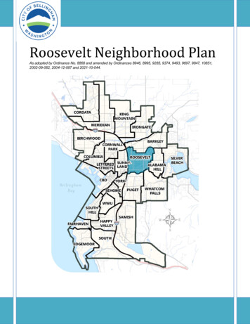
Roosevelt Neighborhood PlanAs adopted by Ordinance No. 8868 and amended by Ordinances 8946, 8995, 9285, 9374, 9493, 9697, 9847, 10851,2002-09-062, 2004-12-087 and 2021-10-044.Roosevelt Neighborhood1
Neighborhood Plan Adoption: In 1980, the Bellingham Plan was adopted and included individual plansfor each neighborhood. When the Washington State Growth Management Act (GMA) was adopted in1990, the City was required to update and amend the Bellingham Plan to include comprehensive planningelements required by the GMA. The Bellingham Comprehensive Plan was adopted in 1995 and againincluded all of the individual neighborhood plans.Neighborhood Plan Amendment: The Bellingham Municipal Code (BMC) 20.20 includes procedures bywhich individual property owners may petition the City for an amendment to an individual neighborhoodplan. This may be a simple text amendment to address a condition or concern in a particularneighborhood or it may be a request for a change to the land use designation in a portion of aneighborhood. Because the neighborhood plans are adopted as part of the Bellingham ComprehensivePlan, the GMA restricts amendments to once per year. The deadline for submitting neighborhood planamendments to the City is December 1 of each year (See BMC 20.20). An amendment to a neighborhoodplan is made by ordinance. All of the changes made to this plan since it was originally adopted are listedon the last page of the plan.Neighborhood Plan Update: Periodically, individual neighborhood plans merit a complete update due tochanges of conditions in the neighborhood and/or the City. A complete neighborhood plan update can bea complex process requiring a great deal of time, public participation, and planning staff resources. Someof the individual neighborhood plans that were originally adopted in 1980 have received completeupdates, while others have not.Roosevelt Neighborhood2
I. NEIGHBORHOOD CHARACTERThe Roosevelt Neighborhood is bounded by Interstate 5 on the west; Whatcom Creek onthe south; Sunset Drive, E. Illinois Street, and the Railroad Trail on the north; and Huronand Michigan Streets on the east. The gentle slope along the northern boundary of theneighborhood creates properties with pleasing views of Bellingham and the Bay to thewest. Within these boundaries the Roosevelt Neighborhood is, in every sense of the word,diverse. Land use ranges from single-family residential to industrial. There areconcentrations of old and new housing units. Styles vary from 100-year old single familyhomes to modern apartment complexes. Though styles vary houses and apartments inthe Roosevelt Neighborhood are generally well maintained. The Light Industrial area isnot without its own mix, with uses ranging from automobile dealerships and warehouses tooffice development.Land in Roosevelt began being subdivided and developed as early as 1889 when thewestern portion of the residential area was platted. Since that time, portions of the areahave continued to be platted with small lots. The total number of residential units in theRoosevelt Neighborhood at the end of 1995 was 2,157. The majority of recent growthhas been in the number of multi-family units, with a total of 903 units in 1995, almostdouble the number recorded in 1987. Single family and duplex development has beenminimal with 1,254 total units in 1995, only 45 units greater than in 1987. The 1995Vacant Land Inventory identified the potential for 646 additional multi-family or duplex unitsin the neighborhood.Click here to view the Roosevelt Neighborhood Open Space MapRoosevelt Neighborhood3
II. OPEN SPACESeveral significant open space features are found in the Roosevelt Neighborhood. TheRailroad Trail, which occupies the former Burlington Northern Railroad line, connectsWhatcom Falls Park to the proposed South Bay Trail west of Interstate 5. This trail is wellused by cyclists and pedestrians and traverses residential neighborhoods, the FeverCreek Wildlife Pond, wetlands, forests and fallow fields, a large shopping center, andRoosevelt Elementary School. Not only does this trail provide a recreational experience,but also serves as an important wildlife link to adjacent corridors and open space.THE RAILROAD TRAIL SHOULD BE UPGRADED AND IMPROVED WITH NEWSURFACING TO ACCOMMODATE INCREASED USE.NATIVE LANDSCAPING ALONG THE RAILROAD TRAIL SHOULD BE ENHANCED TOIMPROVE WILDLIFE HABITAT AND TRAIL USER EXPERIENCE.Some open space south of the Railroad Trail, between Roosevelt Elementary School andSt. Clair Street, has been acquired by the City, adding land to the Greenways system. Inaddition, school district property north of the Roosevelt Elementary School complex,known as the Roosevelt Nature Area, has been targeted for habitat enhancement andinterpretive projects, which could be used by schools, neighbors, and trail users.Roosevelt Elementary School students have worked on environmental studies availableright outside their doors. A portion of this area will be re-created as a wetland to satisfymitigation requirements for wetland impacts at Squalicum High School.THE OPEN LANDS AROUND ROOSEVELT ELEMENTARY SCHOOL SHOULD BEPLANNED AND DEVELOPED JOINTLY AS RECREATIONAL AND EDUCATIONALOPEN SPACE BY THE CITY AND THE BELLINGHAM SCHOOL DISTRICTA TRAIL SHOULD BE BUILT CONNECTING THE RAILROAD TRAIL TO THE SUNSETCOMMERCIAL AREA UTILIZING THE OLD CHICAGO MILWAUKEE RAIL LINE.Fever Creek, another important attribute in the neighborhood, flows in its natural channelfrom its headwaters north of the Railroad trail, but becomes culverted and channelizeddownstream of Alabama Street. The Fever Creek Wildlife Pond, a 3-acre site created asa wetland mitigation requirement, is adjacent to the trail and has become a populardestination for people and wildlife. An interpretive sign describing wetland ecology shouldbe placed at the site. In order for Fever Creek to once again support trout and salmondownstream, the creek will have to be restored to a more natural channel. Developmenthas left little or no buffer along the creek. Therefore, it does not serve as a wildlife corridoror recreational opportunity. Enhancement projects on Fever Creek are needed.Roosevelt Neighborhood4
AN INTERPRETIVE SIGN SHOULD BE PLACED AT THE FEVER CREEK WILDLIFEPOND THAT DESCRIBES THE IMPORTANCE OF WETLANDS TO PEOPLE ANDWILDLIFE.FEVER CREEK SHOULD BE RESTORED TO ONCE AGAIN SUPPORT FISH. BUFFERENHANCEMENTS AND REMOVING CULVERTS ARE NEEDED FOR FISH HABITATIMPROVEMENTS.The Whatcom Creek corridor, which forms the southern boundary of the neighborhood, isthe other significant attribute of the Roosevelt Neighborhood. Forming a greenbelt fromthe 245-acre Whatcom Falls Park near its headwaters to the Maritime Heritage Hatcheryand Park at the mouth, Whatcom Creek has always played a major role in the City ofBellingham. Because of the creek's connection to adjacent wetlands, forest, and otheropen space, the corridor also plays an important role for many of the wildlife species stillfound in the City.The 1989 City of Bellingham Shoreline Master Program requires a 50' setback along thisstretch of Whatcom Creek. Within this setback, the City Parks Department has proposeda bicycle and pedestrian path opening up this area for recreational use. Preservation oflarge trees and restoration of riparian vegetation and habitat are also a part of the trailproposal.ACQUIRE, PRESERVE, AND ENHANCE A GREENBELT ALONG WHATCOM CREEK,INCLUDING DEVELOPMENT OF A MULTI-USE TRAIL.Frequent flooding problems in this stretch of Whatcom Creek were significantly reducedthrough structural modifications during the 1980's, and improvements continue to bemade. Planting trees and native shrubs along the creek continues to be done by volunteergroups as well as through City requirements to offset the impacts of nearby development.Water quality problems may continue but the City Stormwater Ordinance now requirestreatment of runoff water before it enters the creek. In August 1996, a fish ladder wasinstalled by a local service group over a 90-year old sewer line that crosses WhatcomCreek, which had blocked upstream fish passage. Further water quality and fish habitatimprovements are needed to improve the viability of the Whatcom Creek corridor.PROVIDE CONTINUED WATER QUALITY AND FISH HABITAT IMPROVEMENTS INWHATCOM CREEK.Parks in the neighborhood include Pacific Trails Park located along the Railroad Trail andToledo Street, and Roosevelt Park. In addition, the proposed Boys and Girls Club south ofRoosevelt Park will provide much needed recreational opportunities for children andteenagers in the area, and will generate increased use of Roosevelt Park.Roosevelt Neighborhood5
AN AUTOMATED IRRIGATION SYSTEM SHOULD BE INSTALLED AT THEROOSEVELT PARK BALLFIELD. THE BASKETBALL COURTS SHOULD BERELOCATED NEAR THE PROPOSED BOYS AND GIRLS CLUB FOR BETTERSUPERVISION AND TO AVOID CONFLICT WITH PLAYGROUND USE.As new development occurs and the population increases the neighborhood will requiremore open space/recreational land. Additional sites will not only serve the recreationalneeds of a growing neighborhood but also aid in the protection of valued aestheticamenities associated with green, open spaces.In the remaining undeveloped, unplatted residential areas, open space dedication, or feesin lieu of dedication, should be a required part of plat approval. It is intended that bydesignating particular future open space patterns and areas, a more usable and integratedopen space system can be achieved concurrent with development. Many of the openspace patterns follow old railroad rights-of-way and stream corridors. Stream corridors area recreation resource and have value as wildlife areas. Because much of theneighborhood is already platted, implementation of the open space plan is largelydependent upon the City acquiring such sites. Acquisition of parklands in the RooseveltNeighborhood is identified in the 1994 Open Space, Parks, and Recreation Master Plan.OPEN SPACE SITES SHOULD BE ACQUIRED TO SERVE THE GROWING NEEDS OFTHE ROOSEVELT NEIGHBORHOOD.IMPLEMENTATION OF THE OPEN SPACE PLAN SHOULD OCCUR ALONG WITH THEPLATTING AND DEVELOPMENT OF UNDEVELOPED LANDS.In order to minimize the potential problems inherent in the boundaries between land usesof different intensities, vegetated buffers are proposed at those boundaries. While most ofthese buffers are dealt with in the neighborhood plan, there are occasional opportunities tocreate or preserve such buffer areas through open space designation.IT IS RECOMMENDED THAT A TREED BUFFER BE INSTALLED ALONGCAROLINA STREET TO SEPARATE INDUSTRIAL USES FROM LESS INTENSERESIDENTIAL USES.Buffering of adjacent areas from the view, noise, and odor of Interstate 5 is anotherconcern, which relates to visual open space and quality of life.A LANDSCAPED BERM AND/OR BUFFER INCLUDING EVERGREEN TREES SHOULDBE MAINTAINED OR ENHANCED ALONG THE LENGTH OF INTERSTATE 5THROUGH THE RESIDENTIAL PORTIONS OF THE NEIGHBORHOOD ANDRoosevelt Neighborhood6
REMAINING PORTIONS OF THE INTERSTATE 5 CORRIDOR SHOULD BE WELLLANDSCAPED INCLUDING EVERGREENS.III. PUBLIC FACILITIES AND UTILITIESDrainageThe Roosevelt Neighborhood is drained by Whatcom Creek and its tributary Fever Creek.Significant efforts have been made to decrease flooding potential in the neighborhood.While some of the severe drainage problems have been dealt with, continued efforts areneeded to maintain the major drainage ways in an open state. As street systems aredeveloped or redeveloped, drainage should be closely evaluated. To accommodatepresent and future drainage needs of the Roosevelt Neighborhood, the City's WatershedMaster Plan (1995) recommends several actions in the Roosevelt Neighborhood.THE WATERSHED MASTER PLAN (1995) RECOMMENDS THAT NECESSARYSTORM SEWERS WITH RUN-OFF CONTROL SHOULD BE INSTALLED AT FUTUREDEVELOPMENT SITES. CREEKS SHOULD BE MAINTAINED PREDOMINANTLY INTHEIR NATURAL CONDITION AS MAJOR DRAINAGE FACILITIES.In 1982 the City adopted FEMA floodplain management regulations Citywide, including theWhatcom Creek basin. These regulations provide limitations on the location of fill andstructures to maintain the flood carrying capacity of Whatcom Creek. Unfortunately, manystructures already located in the Whatcom Creek floodplain are subject to periodicflooding. In order to alleviate these problems, and in conformance with the 1973Comprehensive Drainage Plan, structural modifications were made to Whatcom Creek torelieve flooding.Realizing the value of the natural drainage ways as they contribute to the "character" ofthe neighborhood, and as they lessen the need to provide expensive sewer systems, thefollowing recommendation is made for the Roosevelt Neighborhood:FEVER CREEK, FROM THE OLD MILWAUKEE RAILROAD RIGHT-OF-WAY TOWOBURN STREET, SHOULD BE PROTECTED FROM ENCROACHMENT BYDEVELOPMENT AND PRESERVED AS AN OPEN DRAINAGE WAY. OTHERNATURAL DRAINAGE WAYS SHOULD BE PRESERVED WHENEVER POSSIBLE.Water Distribution SystemWater service and fire flow is provided by two water pressure zones located within theRoosevelt Neighborhood. Both the North gravity system and the Dakin-Yew pressurezone supply the required flows to this area. The Dakin-Yew zone only supplies a smallarea along the eastern boundary when elevations become to great for the North zonesystem.Roosevelt Neighborhood7
The utility infrastructure for future development is not fully in place for some areas locatednorth of Alabama Street and west of Woburn Street. These properties require water mainextensions to facilitate development. The industrial area south of Alabama Street andwest of Woburn Street may require some system upgrades as future infill occurs. Recentwater main replacements to the area north of Indiana Street and west of Orleans Streethas provided the necessary fireflow for the present zoning needs of that area.The management of the water system in this area will need continual supervision as manyof the water mains are reaching their life expectancy and may require replacement.Sanitary Sewer SystemThe majority of the neighborhood is served by sanitary sewer with only a small portionnorth of Alabama Street and west of Woburn Street without sewer service. This areaneeds to extend existing sanitary mains for service and these sewer improvements willcome about with infill development of vacant land.Because this area has a sanitary system newer than most within the City of Bellingham,replacement and rehabilitation may not be required as soon as some otherneighborhoods. Maintenance should be able to handle any immediate concerns that arisefrom inspections or surveys. The sanitary sewer trunk system, which is located at the farsouthern section of the neighborhood, should be adequate for future upstreamdevelopments.SchoolsChildren from the Roosevelt Neighborhood attend Roosevelt and Sunnyland ElementarySchools, Kulshan and Whatcom Middle Schools, and Bellingham High School. Manyelementary children must walk to school along major arterials and high traffic volumestreets. Concern has been raised about elementary school children walking along, andhaving to cross major arterials, such as Alabama, James, Orleans, Woburn, and IowaStreets. The Safe School Routes Program has addressed portions of these problems byidentifying alternate routes and installing new sidewalks along a number of streets.TO PROMOTE BETTER SAFETY FOR CHILDREN WALKING TO SCHOOL,ALTERNATE ROUTES SHOULD BE IDENTIFIED AND SIDEWALKS SHOULD BEPROVIDED ALONG DESIGNATED SAFE SCHOOL ROUTES.The Roosevelt Neighborhood is the home of the Whatcom Transit Authority bus terminaland Public Works Maintenance and Operations facility.TO LESSEN THE IMPACT ON ADJACENT RESIDENTIAL AREAS, BUFFERINGSHOULD BE PLACED AROUND THE CITY MAINTENANCE AND OPERATIONSFACILITY. VEHICULAR ACCESS TO THIS FACILITY SHOULD BE ORIENTEDTOWARD PACIFIC STREET VIA CAROLINA AND VIRGINIA STREETS.Roosevelt Neighborhood8
IV. POLICEPolice Department staff, residents of the Roosevelt Neighborhood, and Planning andCommunity Development Department staff recognize that crime is an issue in theneighborhood. One way to reduce crime is to employ strategies of Crime PreventionThrough Environmental Design (CPTED). Over the next few years, Planning andCommunity Development staff will continue to work with the Police Department onproviding educational opportunities for building professionals and interested citizens.Specific requirements should be considered for all multi-family, commercial, and industrialdevelopment during the update of the Land Use Development Ordinance.DEVELOPERS ARE ENCOURAGED TO INCORPORATE CRIME PREVENTIONTHROUGH THE USE OF ENVIRONMENTAL DESIGN (CPTED).1Click here to view the Roosevelt Neighborhood Circulation Map1CPTED principles of natural surveillance, natural access control, territorial reinforcement, and maintenance can beused to minimize the potential for crime in new developments. Well-designed buildings, parking lots, garages,sidewalks, and open courtyards and appropriate lighting can be encouraged in new developments.Roosevelt Neighborhood9
IV. CIRCULATIONArterialsAlabama and Iowa Streets provide the major east-west arterial routes through theRoosevelt Neighborhood with 20,300 and 10,500 vehicles per day respectively. WoburnStreet and Pacific-Orleans Streets serve as north/south arterials. Yew Street serves as acollector linking Alabama and Iowa Streets.ALABAMA STREET SHOULD BE WIDENED AT ORLEANS AND PACIFIC STREETSAND RECHANNELIZED TO PROVIDE LEFT TURN LANES AND UPGRADEDSIGNALIZATION.Iowa Street serves the businesses and industries in the southern portion of the RooseveltNeighborhood. Some traffic from the county and northeast Bellingham also uses IowaStreet as an alternate route, other than Alabama, to access central and western portions ofthe City.The 1995 Comprehensive Plan states that Woburn Street should be improved to fullarterial standard with the potential for 4 lanes between Sunset and Yew/Iowa Streets.Four lanes have been provided between Sunset Drive and Illinois Street and two laneimprovements have been completed from Illinois Street to Lakeway Drive.IN ORDER TO REDUCE CONGESTION, WOBURN STREET FROM ILLINOIS TO IOWASHOULD BE CONSIDERED FOR IMPROVEMENT TO FOUR LANES OF TRAVEL BYELIMINATION OF ON STREET PARKING AND MINOR WIDENING. FOUR LANEIMPROVEMENTS IN THIS AREA WILL BE DIFFICULT BECAUSE OF RIGHT-OF-WAYACQUISITION ISSUES.As development continues to occur in and around Civic Field and the Light Industrial areabetween Civic Field and Whatcom Creek, access to Iowa Street from Civic Field would bedesirable. Although difficult to accomplish because of the required creek crossing, thisimprovement would ease congestion around Civic Field.Neighborhood Street StandardsResidential streets are intended to provide abutting properties "local service." In theRoosevelt Neighborhood, many of these streets now have an oil mat surface, are in poorrepair, have open drainage ditches, no sidewalks, provide no on-street parking, and aredifficult and expensive to maintain.WHENEVER STREETS ARE CONSTRUCTED OR UPGRADED, THEY SHOULD BEDEVELOPED TO FULL DESIGNATED STANDARDS.Roosevelt Neighborhood10
THE RECOMMENDED STANDARD FOR RESIDENTIAL STREETS IN THE SINGLEFAMILY AND DUPLEX AREAS IS 28 FEET WIDE WITH CONCRETE CURBS,GUTTERS, STORM DRAINAGE, PARKING AND SIDEWALKS ON BOTH SIDES. APLANTING STRIP SHOULD BE INSTALLED BETWEEN THE CURB AND SIDEWALK.Bicycle FacilitiesA strong bicycle network will reduce automobile use in this high-traffic network, add moreeyes on the street to reduce crime, and make the area more accessible for residents of allages and economic levels. Several bicycle links into the Roosevelt Neighborhood alreadyprovide the backbone of a bicycle network. Many of these links are on existing roads withsufficient width and low enough traffic counts to provide safe biking, such as Texas Street,from Yew to Pacific streets. Other corridors are exclusively bicycle/pedestrian, such as thelink from the Virginia/Nevada intersection south and west to the Kentucky/Mooreintersection.The Roosevelt Neighborhood has the potential to provide many more bike-friendly routes.New bicycle routes should be created when roads are developed or widened and asdedicated bicycle funds become available. These route upgrades should not be onroadways with heavy truck and automobile traffic. Bicycle route upgrades can include bikelane striping, on-street parking restrictions, curb ramps and bollards at path intersectionswith roads, signage, and additional links between existing bikeways.A strong bike network would include the following roadway/trail links:-Nevada Street from Virginia Street to Indiana Street,-Pacific Street from Iowa Drive to Barkley Boulevard,-Yew Street from Iowa Drive to the Roosevelt Elementary School,-St. Clair Street from Whatcom Falls Park to the Railroad Trail,-Iowa Drive and Yew Street (to be used only by experience cyclists),-Texas Street, and Illinois Street from Moore Street to Alabama Hill.These bicycle network links will require acquisition of additional rights-of-way oreasements:-Verona Street and/or Undine Street from Kentucky Street to Barkley Boulevard,-Valencia Street to the Railroad Trail as an alternative to Woburn Street and south toIowa Drive,-A route to Roosevelt Park from the west,-St. Paul Street from Texas Street to Barkley Boulevard,-North Street from Moore Street to Alabama Hill,-Moore Street from the Railroad Trail/I-5 to the Sunset/Orleans area.Click here to view the Roosevelt Neighborhood Land Use MapRoosevelt Neighborhood11
V. SUBAREA DESCRIPTIONS AND LAND USE DESIGNATIONSArea 1This area borders Interstate 5 and extends along the north side of Alabama Street eastto Ontario Street, and contains the great majority of older housing in the neighborhood.BECAUSE THIS AREA IS PLATTED IN SMALL LOTS, AND IN ORDER TOENCOURAGE MAINTENANCE OF OPEN SPACE, DETACHED AND COMMON WALLSINGLE FAMILY UNITS SHOULD BE ALLOWED.ENCOURAGE THE PRESERVATION OF THE EXISTING HOUSING STOCK BYPROVIDING ADDITIONAL HOUSING UNITS ON THE SAME LOT.AREA 1 LAND USE DESIGNATION: MULTIFAMILY RESIDENTIAL, MEDIUM DENSITYArea 1AThis area lies between Racine and Pacific Streets and extends south from the boundary ofthe Barkley Neighborhood to East Illinois Street. Development in this area consists mainlyof single-family residences or duplexes on larger lots. The area is further characterized bymultiple lots under single ownership.Recent developments in the Barkley Neighborhood, particularly to the east of this areahave provided an opportunity for these properties to become a transitional area betweenthe Residential Multi-Planned zoning to the north and east and the Residential MultiTransition zoning to the south and west.Future development in the neighborhood will place greater demands on the existingtransportation facilities. Due to the layout of streets in the neighborhood, E. Illinois Streetfunctions as a neighborhood collector. As lots fronting on E. Illinois are developed,improvements along the north side of the street between Racine and Pacific Streets areneeded to ensure that neighborhood transportation needs are met in an orderly fashionand in concert with new development.AREA 1A LAND USE DESIGNATION: MULTIFAMILY RESIDENTIAL, MEDIUM DENSITYArea 2This area is currently occupied by the Roosevelt Elementary School and contains a largeamount of open space. Joint development and use of this open space by the City and theRoosevelt Neighborhood12
School District is taking place. This open space area, named "The Roosevelt NatureArea" by students from Roosevelt Elementary School, has been targeted for habitatenhancement and interpretive projects for schools, neighbors, and adjacent trail users.Property located between this open space area and the Railroad Trail was recentlyacquired by the City and is included in this area.AREA 2 LAND USE DESIGNATION: PUBLICArea 3This single-family area is located in the northeastern portion of the neighborhood.Fever Creek rises on the northern edge of the area at the base of Alabama Hill. Currently,this area is developed with single-family homes on large lots. Two recent clusterdevelopments have provided smaller lots while preserving significant wetland and openspace areas. Due to the environmental constraints in the area, this type of developmentshould be encouraged.The property formerly located in Area 4 of the Mt. Baker Neighborhood lying south of theRailroad Trail has been included in this area. This site, along with the property to thesouth, is currently under one ownership and is undeveloped. As with much of the area,these properties are characterized by wetlands and the presence of Fever Creek. Thissite also abuts the Roosevelt Nature Area. Providing open space next to the RooseveltNature Area, complimenting the existing single family development to the south, andpreserving wetland features are important to consider as this site is developed.TO PRESERVE THE ENVIRONMENTAL FEATURES IN THE AREA AND TO ALLOWDEVELOPMENT TO OCCUR WHICH WILL PROTECT THE NATURAL SYSTEM,DEVELOPMENT OF DETACHED SINGLE FAMILY HOUSING AT 15,000 SQUAREFOOT LOT SIZE, OR DETACHED CLUSTERED SINGLE FAMILY HOUSING WITH ANOVERALL DENSITY OF 12,000 SQUARE FEET PER UNIT SHOULD BE ALLOWED.AREA 3 LAND USE DESIGNATION: SINGLE FAMILY RESIDENTIAL, LOW DENSITYArea 4This area located adjacent to Interstate 5 has been developed with multi-family housing.Any further development should preserve the open space corridor along the Railroad Trailand maintain a vegetated buffer along the freeway.Roosevelt Neighborhood13
AREA 4 LAND USE DESIGNATION: MULTIFAMILY RESIDENTIAL, MEDIUM DENSITYArea 5This entire 14-acre tract is designated as a Planned Residential-Multi area. The portionof the area located east of St. Paul Street has been developed with multi-family units.Single family residents will be developed on a majority of the property located west ofSt. Paul Street. As part of the approval for these developments the Railroad Trail hasbeen realigned and a park has been provided. Special care should be taken to continueto preserve and develop the Railroad Trail along the Burlington Northern tracks.AREA 5 LAND USE DESIGNATION: MULTIFAMILY RESIDENTIAL, MEDIUM DENSITYArea 6This residential area is a mixture of older and newer single family homes. The plancalls for maintaining the existing pattern of development for this area. BecauseFever Creek flows through this area, drainage should be of particular concern asdevelopment occurs.AREA 6 LAND USE DESIGNATION: SINGLE FAMILY RESIDENTIAL, MEDIUM DENSITYArea 7This area is characterized by a diverse mix of multi and single-family dwellings. It is one ofthe few remaining areas close in with undeveloped parcels suitable for sensitive multipleunit development. Apartments, duplexes, and single-family dwellings are allowed inArea 7. In recent years, the number of infill toolkit and multi-family units in this area hasincreased.The boundary between this high-density residential zone and the lower density residentialzone north of Alabama Street shall be maintained.Drainage problems have increased here as more impervious surfaces have been created.Both short and long-term solutions need to be sought to improve the drainage situation.AREA 7 LAND USE DESIGNATION: MULTIFAMILY RESIDENTIAL, HIGH DENSITYRoosevelt Neighborhood14
Area 8This Neighborhood Commercial area is bounded by Alabama Street on the north, YewStreet on the west, Superior Street on the east, and extends to include one lot depth southof Texas Street. A Planned designation is added to required future development to bereviewed through the planned contract process. Permitted uses and setback requirementsshall be as allowed under the Neighborhood Commercial zoning designation. Reductionof these setback requirements for properties located on the south side of Texas Streetmay be granted for building and parking facilities provided the intent of the setback isaddressed through a combination of setback and screening/landscaping.The existing shopping center serves residents from the Roosevelt and Alabama HillNeighborhoods. This neighborhood commercial area shall not extend further east into theresidential area.In order to minimize the impacts of neighborhood commercial development on thesurrounding neighborhood, special consideration should be given during the plannedcontract and building permit review processes. Vehicular ingress and egress forproperties along Superior Street should be limited to the alley with buildings frontingSuperior Street. Joint driveways for properties on the south side of Texas Street should beprovided. Parking areas should be located to the rear or sides of the buildings.Landscape screening should be provided for the residential properties located acrossSuperior Street. Landscape buffers should be provided where commercial uses abutresidential uses.AREA 8 LAND USE DESIGNATION: COMMERCIALArea 9Development in this area includes numerous single-family houses and duplexes and a fewapartments. Because this area is adjacent to Saint Clair Park and is now used for accessto the park, pedestrian and bicycle access to the park should be retained whendevelopment occurs. This area has seen an increase in the number of duplex structuresand has the potential for an additional 140 units. Some of the land in the eastern portion ofthis area is steeper hillside land and development should recognize this constraint as wellas the potential drainage impacts. The special condition is included because many of thelots in this area are relatively large and more than one duplex should be allowed to be builton these provided the overall density requirement is met.AREA 9 LAND USE DESIGNATION: MULTIFAMILY RESIDENTIAL, MEDIUM DENSITYRoosevelt Neighborhood15
Area 9AAREA 9A LAND USE DESIGNATION: MULTIFAMILY RESIDENTIAL, MEDIUM DENSITYArea 10This area is wholly occupied by the Whatcom Transit Authority and the City Department ofPublic
Land in Roosevelt began being subdivided and developed as early as 1889 when the western portion of the residential area was platted. Since that time, portions of the area have continued to be platted with small lots. The total number of residential units in the Roosevelt Neighborhood at the end of 1995 was 2,157. The majority of recent growth