Transcription
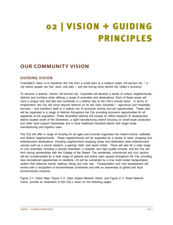
Coachella’s vision is to transform the City from a small town to a medium-sized, full-service city – acity where people can live, work, and play – and the driving force behind the Valley’s economy.To become a diverse, vibrant, full-service city, Coachella will develop a series of unique neighborhoods,districts and corridors while offering a range of amenities and destinations. Each of these areas willhave a unique look and feel and contribute in a distinct way to the City’s overall vision. In terms ofemployment, the City will move beyond reliance on its two main industries – agriculture and hospitalityservices – and transform itself to a mature mix of economic activity and job opportunities. These jobswill be organized in a range of districts throughout the City providing economic opportunities for allsegments of the population. These diversified districts will include an office/research & developmentdistrict located south of the Downtown, a light-manufacturing district focusing on small-scale productionand other local support businesses and a more traditional industrial district with larger-scalemanufacturing and logistics uses.The City will offer a range of housing for all ages and incomes organized into mixed income, walkableand distinct neighborhoods. These neighborhoods will be supported by a variety of retail, shopping andentertainment destinations, including neighborhood shopping areas and destination-style entertainmentvenues such as a soccer stadium, a gaming “strip” and resort hotels. There will also be a wide rangeof civic amenities including a diverse downtown, a hospital, and high-quality schools, and the City willform strong partnerships with the College of the Desert. The residential, commercial and civic sectorswill be complemented by a wide range of passive and active open spaces throughout the City providingnew recreational opportunities to residents. All will be connected by a true multi-modal transportationsystem that balances transit, walking, biking and auto use. Transportation and new development willevolve with a recognition of environmental constraints and with an awareness of global and localenvironmental concerns.Figure 2-1: Vision Map, Figure 2-2: Open Space Network Vision, and Figure 2-3: Road NetworkVision, provide an illustration of the City’s vision on the following pages.VISION GUIDING PRINCIPLES 02-1
Page intentionally left blankVISION GUIDING PRINCIPLES 02-2
Figure 2-1: Vision MapVISION GUIDING PRINCIPLES 02-3
Page intentionally left blankVISION GUIDING PRINCIPLES 02-4
Figure 2-2: Open Space Network VisionVISION GUIDING PRINCIPLES 02-5
Page intentionally left blankVISION GUIDING PRINCIPLES 02-6
Figure 2-3: Road Network VisionVISION GUIDING PRINCIPLES 02-7
Page intentionally left blankVISION GUIDING PRINCIPLES 02-8
The Guiding Vision comprises of 20 Guiding Principles that will be key to the success of achieving theVision as the City grows. These components are described below, providing clear and conciseexplanation of the Vision and how it will be realized.In the future, Coachella will be Coachella will be distinct from the other cities in theCoachella Valley, an authentic California desert town,exhibiting strong traditional architectural elements of theregion’s history. Additionally, the City will be comprisedof walkable neighborhoods in high demand by newarrivals to the Valley and different from the conventionalsubdivisions that populate the Valley. With this distinctcharacter and its geographic location, the City becomesthe eastern gateway to the Coachella Valley.Coachella will be a complete City at the conclusion ofFigure 2-4: Walkable neighborhoods that preserveeach economic cycle. The City will grow incrementallyCity's history also support active lifestyles forover time in a way that maximizes investments, enhancesexisting and new residents.connectivity and efficient land use, and saves costs forthe City. This will allow the City to grow in a scalable manner that provides complete neighborhoods,complete streets and a complete City over the course of each economic cycle. With major developmentopportunities within the heart of the City and on its eastern edge, the next phase of development willconcentrate development in the areas around Avenue 50 and 52. New development will generally becontiguous (or proximate) to existing development and leapfrog development will be avoided.Coachella will have a range of housing and will have homes for people across generations, culturesand incomes. This will help reinforce the community’s economyand increase social equity by providing opportunities for peopleand families to live and stay in Coachella, going from onehousing type to another as their needs and means change overtime.Coachella will have thriving, neighborhood-scale retail. As afull-service city, Coachella will offer diversity of retail services.There will be a series of neighborhood shopping nodes, orFigure 2-5: Walkable neighborhood retail“village centers” located throughout the city. These villagealso helps support the local economic base.centers are smaller, compact and walkable retail nodes andinclude markets, restaurants, cafes and professional services and will serve to provide the communityVISION GUIDING PRINCIPLES 02-9
members with their everyday needs. The village centers will be attractive, connected via sidewalks andbike trails to neighborhoods and, in somelocations, include high-density housing.Coachella’s Downtown will be the heart of theCity. The Downtown plays an important role,giving the City a sense of place and a location forcommunity and civic gathering, and its continuingviability will play an important role in Coachella’sfuture success. A vision for the Downtown wasdeveloped through the Pueblo Viejo RevitalizationPlan, and implementing this plan is a priority forthe City. In general, the Downtown should focuson civic, arts and residential uses, including thenew city hall, an expanded library, a seniorcenter, medium- and high-density housing, artFigure 2-6: A downtown with complete sidewalks promotesgalleries and retail uses. New restaurants shouldactivity and a rich city center.also be located in the Downtown area to serveboth daytime employees (in the office/R&Ddistrict to the east) and also create a city-wide and regional dining destination.Coachella envisions a future which includesthriving physical, emotional and spiritual health forthe entire community. Neighborhoods will provideopportunities for residents to improve theirphysical and mental health while meeting dailyneeds – walking to the store, meeting friends,bicycling to school, taking transit to work andhaving access to nutritious and affordable foodsthat can be purchased or grown in theneighborhood. The City will find innovativesolutions to ensure its streets, parks and publicspaces are safe, accessible and inviting for allusers.Figure 2-7: Incorporating fun places for people of all agesto play will promote activity and a variety of recreationopportunities.The future of the City will include a significant amount of parks, open space and other public spaces.These should be dispersed throughout the City and connected via networks of trails and “green streets.”Specific ideas for this include new, major recreational facilities for soccer, football and baseball, anetwork of small- and medium-scale neighborhood parks, and multi-use recreational trails along theWhitewater River and the Coachella Canal with southwest-northeast fingers that run toward the hillsidesnortheast of the City. The Downtown, employment districts and village centers will include plazas andtown squares that can serve as meeting places for residents and visitors. Additionally, where safe andfeasible, the City will capitalize on environmental constraints such as faults, channels and liquefactionand landslide zones to achieve these open space and park objectives.VISION GUIDING PRINCIPLES 02-10
Coachella will be a walkable community where neighborhoodswill have many amenities within easy walking distance ofhomes. The pedestrian environment is safe and inviting andresidents, including the young and the old, have equalpedestrian access to everyday service and destinations.Coachella will have a balanced, multi-modal transportationsystem and neighborhoods that are ready for transit. Streetswill be planned and designed to accommodate multiple modesand prioritize community design that fosters accessibility totransit. These streets will accommodate future Bus RapidTransit, have safe bicycling facilities and be pleasant to walkalong. Walking and cycling amenities will be organized in aFigure 2-8: Outdoor cafes invite pedestrianhighly connected network. Streets and neighborhoods will beactivity and move people away from drivedesigned in tandem to reinforce the balanced operations ofmultiple modes of transportation.thrus.Coachella will have great opportunities for lifelong learning. The community will have access toeducation resources and facilities within the City. In turn, better access to education and public serviceswill increase social cohesion and support local economic development as great educational opportunitiesand a highly trained workforce will increase the City’s economic opportunities. Siting and constructing acampus of the College of the Desert within Coachella will help achieve this vision by expanding thelocal opportunities for training and lifelong learning. Additionally, a new college or university nearDowntown would expand the City’s potential for research and development-based industries and helpreinforce the revitalization of the Downtown.Figure 2-9: Complete streets provide the built environment that will support economic, civic, and retail activity formany generations.VISION GUIDING PRINCIPLES 02-11
Coachella will be a highly accessible community. The future network will allow dispersed road accesswith many choices across the City, instead of concentrating traffic on a few major arterials. To achievethis, east-west and north-south roadways should be spaced approximately every quarter or eighth of amile. Additionally, all new development projects – residential and non-residential – will be planned andconstructed with small block sizes and frequent transportation connections to support access to, andthrough, the developments. Given that the City will grow from a small town into a medium-sized City,plans should be made for a comprehensive network of transit, bike paths and other non-driving options,ensuring access and mobility for all age and income levels, more active lifestyles and will address thegrowing concern over global climate change.The City has a clear vision of a highly desirable community with beautiful, livable neighborhoods. Toachieve this vision and an improved standard of living, every future development project must meet theCity’s high standards for design quality and building construction.Entertainment uses will play an important part inCoachella and will be comprised of casinos,sports complexes, resorts, destination retaildistricts, arts, cultural venues and perhaps evena theme park. These regional entertainmentuses will help establish Coachella as adestination in both the Coachella Valley andSouthern California.Figure 2-10: Regional attractions will offer residents andThe City has a rich history and Coachella’svisitors entertainment opportunities and support the economystrong cultural traditions will be reinforcedwithin the City.through the community’s development, not onlyin the form of new development but also through the types of uses that come to Coachella. Art will beintegrated into public places, enriching community centers and streetscapes and supporting local artists.The emphasis on culture will attract small galleries, a performing arts theater and a local cultural historymuseum.Coachella will have a diverse, resilient economy. Developing a strong economy is imperative to thefuture success of the City. The economic and employment vision calls for transforming the City from atwo-industry town (agriculture and hospitality) to a city with great diversity of economic activity anduses. These uses will include small manufacturing, warehousing and distribution, large-scale industrial,office and professional, resort- and entertainment-related services, research and development, healthcare and retail. In addition to providing jobs for a large portion of the community, the diverse economywill also be resilient, better able to withstand the ebb and flow of regional and global economic cycles.VISION GUIDING PRINCIPLES 02-12
Coachella will have a healthy, sustainable agriculturaleconomy. Agriculture has always been a primarycomponent of the City, providing jobs, major economicactivity and physical definition to the community. Agriculturehas the potential to continue to play an important role inthe City’s economy but can only do so if this importanteconomic resource is managed appropriately. By focusingthe next wave of growth between Avenues 50 and 52, theCity’s agricultural base can remain largely intact, supportingthe greater agricultural economy in the valley.Figure 2-11: Preserving agriculture as a largepart of the City's economy will promote localfood and job opportunities.The City will support and implement measures to raiseproperty values by capitalizing on the City’s natural resources and improving average householdincome. Additionally, a key element of this principle will be implementing efficient infrastructure andcommunity building patterns by making sound development decisions and phasing in new developmentto not unduly burden the City with infrastructure maintenance costs.Coachella has stunning views of the hillsides, the verdant agricultural fields along with the amenities ofthe Coachella Canal and the Whitewater River. The City also straddles the San Andreas Fault, which,in turn, helps define the extreme topographical differences within Coachella. The natural amenitiesprovide great value to the City, through economic activity and aesthetics. The City will respect andpreserve these amenities, which create value in its neighborhoods, preserve its economy, provideregional access along recreational trails and conserve for future generations.Coachella is an old town with a rich history. Thepreservation of its historic and cultural resources is essentialto maintaining the sense of traditional continuity andcommunity pride as the City grows. When new developmentcomes into the City, community heritage is taken intoconsideration and will be reflected in the design of thebuildings, neighborhoods, parks and streets.Coachella has a rich history of an active populace,producing advocates and strong community leaders. Thenotion of democracy and participation in public process is astrong tradition in Coachella playing a strong role in thedevelopment of the General Plan. The City and itscommunity leaders will continue to foster this process of openmaintaining the tradition of participation in civic affairs.VISION GUIDING PRINCIPLESFigure 2-12: Public art embraces culturalhistory and can strengthen the socialcommunity fabric.dialogue, public process and democracy, 02-13
Like any great city, Coachella has developed around the basic unit of the neighborhood. A trueneighborhood is not a subdivision but a unique and identifiable area designed around a center with apedestrian-friendly mix of uses and a range of housing for people in all stages of life. In truth, thewalkable neighborhood is the fundamental building block of the best towns. Neighborhoods are oftendefined as the area within a quarter mile walking distance from the center to the edge, which mostresidents can walk to meet their daily needs. This represents a marked shift from approachingdevelopment through individual subdivisions. The City will not follow the path of so many otherCalifornia communities and become one of incomplete subdivisions. With this Plan, each newsubdivision will be considered within the context of the larger unique, walkable neighborhood that it ishelping to build.Figure 2-13: Comprehensive planning allows for neighborhoods and communities that will be livable and healthy forall residents, and promote overall wellbeing for City residents.VISION GUIDING PRINCIPLES 02-14
Coachella is a desert community ofapproximately 40,000 people located at theeastern end of the Coachella Valley, inRiverside County, California. The City wasfounded in 1876 and later incorporated in1946. Before the settlement of the CoachellaValley by Europeans, the Valley was home tothe Agua Caliente band of Cahuilla Indians.The Cahuilla Indians are the first knownhuman inhabitants of the Coachella Valley.The Cahuilla were hunters and gatherers,generally divided into three groups based ontheir geographic setting: the Pass Cahuilla ofthe Beaumont/Banning area; the MountainCahuilla of the San Jacinto and Santa RosaMountains; and the Desert Cahuilla from theCoachella Valley, as far south as the SaltonSea. Varying clan groups of the DesertCahuilla had many villages throughout theCoachella Valley. Planted crops, as well ashunting and gathering, was identified as theprimary way of life for the Cahuilla. BeforeEuropean contact, population for theCahuillas ranged from 3,600 to as high as10,000. Due to European diseases, such assmallpox, the Cahuilla population wasdecimated during the 19th century. The firstofficial United States land survey in SouthernCalifornia in the mid-1850’s noted eightIndian villages or Indian rancherias within, orjust outside, the present boundaries ofCoachella, presumably occupied by the DesertFigure 3-1: Coachella circa 1949.Cahuilla people.A number of roads and trails were observed crisscrossing the planning area, connecting the villagesand rancherias to one another. Two of these roads and trails, both traversing through the planning areain a northwest-southeast direction, appear to have been the main thoroughfare for traffic in the vicinity.One road passed through the planning area in the southwestern corner while the other was recordedEXISTING CONDITIONS 03-1
along the Whitewater River bed, running directly through the center of the planning area. These twomain roads were considered to be two branches of the ancient Cocomaricopa Trail.With the discovery of gold in California in 1848, the first wave of non-Native American immigrantsbegan arriving in California. In 1862, this ancient Cocomaricopa Trail was “rediscovered” by WilliamDavid Bradshaw, and soon became known as Bradshaw Trail as he transformed the route intoRiverside County’s first road. A stagecoach was put into service adjacent to this trail as gold minersand settlers began arriving in the Valley via the Trail.In 1866, development of the Southern Pacific Coachella Valley railroad brought waves settlers to theCoachella Valley, and a series of new communities sprang up along the tracks. Once the SouthernPacific Railroad route connecting the desert and Los Angeles was completed in 1877, the Valley’spopulation began to expand more rapidly. By the early 20th century, Euroamerican settlements hadreplaced the Indian villages and rancherias to become the prevailing cultural landscape in the area.In the 1920s and 1930s, U.S. Highways 99 and 60-70 were completed, further facilitating travel,migration and economic growth in the Valley’s primary economic sectors for tourism and agriculture.Palm Springs and neighboring cities became a major destination for Hollywood celebrities and othervacationers during the years before World War II. The Valley’s population continued to grow during thewar as troops from nearby training centers came to Palm Springs and other cities looking for relaxationand entertainment.The highways, combined with major irrigation projects that brought water from the Colorado River, havesupported a prosperous agricultural sector. By the 1940s, the planning area showed significant growthin population and agriculture. The cities of Coachella and Indio, and the unincorporated areas of Meccaand Thermal became known for niche crops such as dates, grapes, lemons, oranges, avocados, figs,persimmons and even mangos. The fast-growing date palm industry in the Coachella Valley hadbecome the main agricultural staple in the region. Since the late 1940s, the Coachella Canal hasserved as the main water supply for residents of the Coachella Valley.The completion of the Coachella Canal had a dramatic impact on the growth of the Coachella Valley,taking place in the western portion of the City south of the Coachella Canal, while the eastern portion,north of the canal, essentially remained untouched by civilization.While Coachella has been a small town since its inception, its population has grown very quickly.Between 2005 and 2010, the City’s population increased by nearly one-third, jumping from 30,879 to40,704 in only five years. And, the City’s population is expected to continue to grow at a high rate forthe foreseeable future. The Southern California Association of Governments 2012 RegionalTransportation Plan estimates that Coachella could grow to 70,200 by 2020 and 128,700 by 2035.This is a massive amount of growth that the City must be prepared to accommodate.EXISTING CONDITIONS 03-2
In 2010, 40,704 people lived in the City of Coachella’s 8,998 occupied housing units. On average,4.51 persons were living within each occupied housing unit. As compared to the statewide (2.96) andcountywide averages (3.2), Coachella had more persons living within each occupied unit. Further, theaverage number living in mobile homes was 5.8 persons in 2007.1Table 3-1: Housing Occupancy2HOUSINGOCCUPANCYOCCUPIEDUNITS% OF OCCUPIEDUNITSPOPULATIONPERSONS NTER-OCCUPIED3,41237.915,1274.43In Coachella, 62.1% of the housing units were owner-occupied and 37.9% were renter-occupied in2010, and 21.7% of homes are in multi-family structures. As compared to California as a whole, thiswas a higher proportion of owner-occupied units (56%) and lower proportion of renters (44%).Riverside County had 67% owner-occupied units and 33% renter-occupied units.In Coachella, 62.1% of the housing units were owner-occupied and 37.9% were renter-occupied in2010, and 21.7% of homes are in multi-family structures. As compared to California as a whole, thiswas a higher proportion of owner-occupied units (56%) and lower proportion of renters (44%).Riverside County had 67% owner-occupied units and 33% renter-occupied units.The jobs-housing ratio is a basic tool to measure whether the number of jobs and housing units withina community are roughly equivalent. In Coachella, the jobs-housing ratio was 0.65 (5,831 jobs 8,998 housing units) in 2010. The recommended standard for jobs-housing unit ratios is based on theassumption the average number of workers per household is approximately 1.5. As such, the Coachellajobs-housing ratio is significantly lower than the recommended standard, indicating the area is job-poor,requiring many of workers to travel outside the jurisdiction to find employment.In 2010, there were 5,831 jobs in Coachella, 11% below the 2007 total of 6,593. The total includedsalary and wage jobs held by business owners and self-employed individuals. For particular sectors,total manufacturing jobs numbered 208, construction accounted for 245, retail trade jobs numbered 867and professional and management accounted for 555 jobs.31A 2007 Poder Popular report.U.S. Census Bureau (2011). 2010 Census Summary File 1— California).3Southern California Association of Governments, (2011). Profile of the City of Coachella. Available erside/Coachella.pdf.2EXISTING CONDITIONS 03-3
Figure 3-2: Jobs by Sector in 20104Information, 0.2%Construction, 4.2%Manufacturing,3.5%Wholesale, 6.8%Agriculture, 29.7%Retail, 14.7%PublicAdministration ,0.7% Leisure Hospitality,4.1%11.3%WarehousingUtilities, 12.6%Professional-Finance-Insurance-Management, 9.4%Real Estate, 1.1%In March 2012, the unemployment rate in Coachella was higher than neighboring communities andcounty and statewide averages. The California Employment Development Department reported theunemployment rate in Coachella was 20%, higher than the California unemployment rate (11%) and theRiverside County rate (12.7%). Table 3-2 shows the unemployment for cities in the Coachella Valley,Riverside County and statewide in March 2012. Between 2006 (before the recession) and 2012, theunemployment rate in Coachella rose 169%, increasing from 8% to 20%. Similarly in Riverside Countyover the same period, the unemployment rate increased 169%, from 5% to 12.7%.54Southern California Association of Governments, (2011). Profile of the City of Coachella. Available erside/Coachella.pdf.5Bureau of Labor Statistics. (2012). Local Area Unemployment Statistics. Available at http://data.bls.gov/cgi-bin/dsrv.EXISTING CONDITIONS 03-4
Table 3-2: Unemployment Rates in March 20126REGIONUNEMPLOYMENT RATE MARCH 2012COACHELLA20.0%INDIO13.8%PALM DESERT7.6%RIVERSIDE COUNTY12.7%CALIFORNIA11.0%According to the American Community Estimates (2008-2010), approximately 24% of the householdsin the City had income below the Federal poverty level during the last 12 months. This was significantlyhigher than the countywide (13%) and statewide (14%) averages. Further, 28% of the householdsearned incomes less than 25,000 per year and 51% of households earned less than 50,000 peryear.At the time this plan was prepared, 18,530 acres of the City was developed. The City’s Planning Areaof 45,300 acres is only partially developed, with nearly 27,000 acres undeveloped. Of thatundeveloped land, approximately 10 percent of it has been entitled for future development. Most of theCity’s houses are modest, varying greatly in vintage. However, many of the City’s neighborhoods sufferfrom an incomplete transportation network, unfinished subdivisions, poor access and limited parks andneighborhood serving uses. The City’s urban fabric is in need of repair.The land uses within Coachella’s various neighborhoods and commercial areas include residentialhousing, public spaces (parks and streets), industrial activity and commercial activities, such asrestaurants, retail stores, offices, and services. Some areas within the City’s commercial areas have amix of uses, including commercial and industrial on the same parcel, or on neighboring parcels. Table3-3 identifies the total distribution of existing land uses in Coachella as of 2008.6California Employment Development Department (2012). Labor Market Information. Available athttp://www.labormarketinfo.edd.ca.gov/.EXISTING CONDITIONS 03-5
Table 3-3: Land Use DesignationsLAND USE CLASSIFICAT IONAGRICULTUREACRES% OF TOTALAREA% OF TOTAL AREAEXCLUDINGAGRICULTURE ANDVACANT LAND11,17433%-COMMERCIAL AND 1%GENERAL OFFICE1010.3%2%INDUSTRIAL8923%18%MIXED COMMERCIAL AND INDUSTRIAL50.01%0%MULTI-FAMILY RESIDENTIAL550.2%1%OPEN SPACE AND PARKS1090.3%2%OTHER T18,22453%-GRAND TOTAL34,322100%100%SINGLE FAMILY RESIDENTIALTRANSPORTATION, COMMUNICATIONS, UTILITIESUNDER CONSTRUCTIONAgricultural land comprises approximately 33% of the area. Transportation, communications and utilitiescomprised 6% of the land area, and both single family residential and industrial land account for 3% ofthe land area. All other uses comprised 2% of the land area. By excluding agriculture and vacant lands,transportation, communications and utilities comprised 38% of the land area, single family residentialrepresented 20% of the land area, and industrial land accounted for 18% of the land area. All otheruses comprised 24% of the land area.According to the 2010 Census, the population density of Coachella was 2.20 persons per acre for theentire city. 7 The population density was about four times higher than the county and six times higherthan the state. Compared to other cities, however, Coachella’s population density was lower than PalmDesert (2.82), Indio (4.07) and Riverside (5.58). However, when looking at population density for onlythe developed areas of the city (west of SR86), the result is much different; Coachella’s developedareas have a density of 6.71 persons per acre. Although Coachella’s residential development patternsare similar to the rest of the region, some neighborhoods have smaller lots and household size inCoachella is much larger than other geographic areas.7U.S. Census Bureau (2011). 2010 Census Summary File 1— California).EXISTING CONDITIONS 03-6
Population is not uniformally distributed in Coachella, ranging from zero on the eastern and southernsides of Coachella to more than 30 people per acre. Figure 3-3 shows the population density withinthe Coachella city limits and General Plan Planning Area.Figure 3-3: PopulationDensity - Persons per AcreThe layout and quality of the streetscape varies significantly by neighborhood and City region. In someolder residential communities, sidewalks are separated from roadways by landscaped parkways, oftenincorporating grass and shade trees. In the newer residential areas, sidewalks are typically adjacent tothe curb and gutter while landscaping is minimal. There are examples of utility poles and street lightsembedded directly into the sidewalk in these areas, creating obstructions and potential hazards in lowlight conditions.Sidewalks are generally continuous in the residential neighborhoods, though there are occasionally gapsin connectivity between neighborhoods. In more newly developed areas of the City, residential tractsmay have sidewalks within the community and on the major roads immediately adjacent but sidewalksmay not extend all the way to the next development, c
The City has a clear vision of a highly desirable community with beautiful, livable neighborhoods. To achieve this vision and an improved standard of living, every future development project must meet the City's high standards for design quality and building construction. Entertainment uses will play an important part in