Transcription
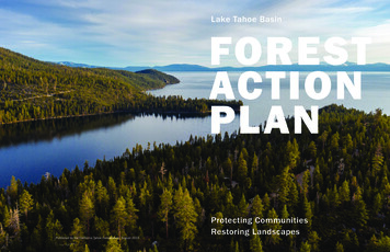
Lake Tahoe BasinFORESTACTIONPLANPublished by the California Tahoe Conservancy, August 2019Protecting CommunitiesRestoring Landscapes
WILDL AND - URBAN INTERFACE TREATMENTSLAKE TAHOE BASIN IGNITIONS 2010–2017THE FORE ST ACTION PL AN (PL AN) CONTAINSthree overarching strategies that support completingand maintaining all wildland-urban interfacetreatments, and implementing large-landscaperestoration:L AKE TAHOE BASIN L AND OWNERSHIP1. Scale up to match the scale of the solution tothe scale of the threat.Develop and Implement LandscapeScale InitiativesStreamline Planning and PermittingCreate Powerline Resilience Corridors2. Build capacity for all phases of the forestlandscape management cycle.Lake TahoeExpand the Restoration WorkforceAdapt for Organizational EffciencyStrategically Use Prescribed FireUSDA Forest ServiceState of NevadaState of CaliforniaPrivate & Local Government155,000 ac7,000 ac13,500 ac28,000 acIncrease Restoration Byproduct Utilization3. Leverage technology for rapid, large-scale,more efcient implementation.OWNERSHIP OF UNDE VELOPEDRE SIDENTIAL LOT SLaunch the Technology Innovation SprintImprove Decision Making through BetterData ManagementEnable Rapid Response through a WildfreCamera Network350 wildfre ignitions(red dots) wererecorded in the LakeTahoe Basin from 2010to 2017. Over 80 percentwere human caused.LAST YEAR BROKE RECORDS for the largest, deadliest,most destructive, and most expensive wildland fres. Moreacres burned in California and Nevada than in any otherstates. Climate change projections suggest that suchlevels of destruction could soon become commonplace.Lake Tahoe straddles the border of California and Nevada,seemingly undisturbed by wildfre. But wildfre, drought, anda potential bark beetle epidemic threaten the communitiesof the Lake Tahoe Basin (Basin) and the treasured landscapethat 24 million visitors enjoy every year.Responding to the increasing threat to our forests, thepartner organizations of the Tahoe Fire and Fuels Team(TFFT) developed this Plan to proactively minimize thegrowing risk. The Plan charts a path for collaborationacross property boundaries to accelerate landscaperestoration and community wildfre protection.ExampleNeighborhoodThe Plan implements the Forest Health focus area of theBasin’s Environmental Improvement Program, the signaturepartnership to restore and protect Tahoe’s natural resources.The vitality and resilience of the Basin’s natural landscapeand human communities have long been inextricably linked.The Washoe Tribe of Nevada and California has a 10,000year history of environmental stewardship in the Basin. TheWashoe Tribe’s unique knowledge and guardianship of theBasin and its plants and animals guide and support partnerrestoration activities.The Plan aligns with state and federal plans andmandates that call for increasing the pace and scale offorest management including Nevada’s Cohesive StrategyImplementation Plan and Forest Action Plan, CaliforniaExecutive Orders B-52-18 and N-05-19, and USDA ForestService Region 5’s Ecological Restoration Leadership Intent.2USDA Forest ServiceStates of NV & CAPrivate & Local Government3,000 lots4,000 lots6,300 lotsWithin Basin neighborhoods over 13,000 small undeveloped lots are intermixed with homes, forming a densepatchwork. The USDA Forest Service, California Tahoe Conservancy, and Nevada Tahoe Resource Team havecompleted nearly 100 percent of initial treatments on these public lots to complement neighbors’ defensiblespace. The TFFT is prioritizing continued maintenance and helping private landowners treat their lots.3
FROM VULNERABILIT Y TO RESILIENCEOver the next five years, the TFFT will treat an additional22,000 acres in the wildland-urban interface (completingall initial treatments) and help residents and businessesachieve nearly 100 percent compliance with defensiblespace requirements.FIRE), Nevada Division of Forestry, and Tahoe RegionalPlanning Agency. Seven fire districts and the TahoeResource Conservation District lead the Tahoe Networkof Fire Adapted Communities. They help prepare familiesand neighborhoods for evacuation, create defensiblespace, and make homes less vulnerable to fire embers.On June 24, 2007, embers from an illegal and abandonedcampfire ignited the most destructive fire in Tahoe’shistory. Stoked by strong winds and overgrown forests,the Angora Fire destroyed 254 homes and structures andburned 3,100 acres within hours. If another large fireoccurs on a summer day, hundreds of thousands of visitorswill overwhelm the Basin’s limited evacuation routes.The Lake Tahoe Basin Multi -Jurisdictional Fuel Reductionand Wildfire Prevention Strategy guides the TFFT ’swork. Accordingly, TFFT partners have treated 57,000acres in the WUI since 2008. These multiple - benefitthinning and prescribed fire treatments connect to formcontinuous areas where fire behavior is reduced andforest health is improved.The TFFT formed in 2008 with the twin aims of reducingfuels in the wildland - urban interface (WUI) and preparingcommunities for wildfire. The partnership involves 21 federal,tribal, state, and local conservation, land management,and fire agencies, including the USDA Forest Service (USFS),California Department of Forestry and Fire Protection (CALFUNDS EXPENDEDACRES TREATED10k 20M9k8k 15M7k6k5k 10M4k3k 5M2k1k——2008 2009 2010 2011 2012 2013 2014 2015 2016 2017 20182008 2009 2010 2011 2012 2013 2014 2015 2016 2017 2018Acres treated lag one to two years behind expenses due to contract timelines. Multiple-year funding from 2008 to 2010 allowedpartners to quickly ramp up treatments. Since then, annual funding has reduced signifcantly.Before 20042014The USDA Forest Service,California Tahoe Conservancy,and Nevada Tahoe Resource Teambegin fuel reduction treatmentson undeveloped public lots2007The TFFT revises theMulti -Jurisdictional Strategyto align with state andfederal prioritiesCalifornia State Parks and NorthLake Tahoe Fire District useprescribed fire to reduce fuelsand improve forest healthThe Angora Fire burns inSouth Lake Tahoe andpartners develop theMulti -Jurisdictional Strategy2017California State Parkscompletes most of its initialWUI treatments and shifts tomaintaining the treatmentswith prescribed freU.S. Forest Service completesplanning for its remaining initialWUI treatments20202025 & beyondNevada Tahoe Resource Teamand Nevada fre districts completetheir initial WUI treatmentsComplete planning forall remaining initial WUItreatmentsMaintain WUI treatmentsand continue implementinglandscape restoration200420082011201620192022Basin fre districts complete CommunityWildfre Protection Plans that identifypriority actions to reduce hazardsThe TFFT forms toredouble communityprotection effortsNevada Tahoe Resource Team begins usingprescribed fre to reduce fuels and improveforest health in Lake Tahoe Nevada State Park.Partners launch theLake Tahoe WestRestoration PartnershipComplete the LakeTahoe West LandscapeRestoration StrategyBegin implementingLake Tahoe Weston-the-ground treatments45
A VISION FOR RESILIENT L ANDSCAPES AND COMMUNITIES1. Homes are built, maintained, and retroftted toresist ignition by fre embers.Residents and visitors alike depend on the Lake Tahoe Basin’srecreation opportunities (and associated economy), clean water,health benefits, wildlife, and natural beauty. Increasing resiliencemeans taking action from the shoreline to the ridgetop.2. Residents and visitors are prepared for evacuation.3. Defensible space surrounds homes to reduce thewildfre threat.4. Forests in the wildland-urban interface (about ¼mile from communities) have tall, healthy treesand little fammable undergrowth.5. The forests beyond form a mosaic of different sizesand types of vegetation, providing diverse habitatfor wildlife.6. Forests near powerlines are managed tosafeguard against ignition, reduce fuels, andimprove forest health.7. Prescribed fres burn mainly on the forest foor,reduce fammable undergrowth, and lead tohealthier and more resilient forests.8. Streams and riparian areas are restored sothat natural processes like fres and foodskeep hardwoods and meadow vegetationhealthy and thriving.
STREAMLINE PL ANNING & PERMIT TINGSCALING UPThe climate crisis is outpacing our forest management.Wildfres in the west are becoming larger and more destructive.Insects have killed 150 million trees throughout the SierraNevada. The Basin cannot address these threats withoutmatching the scale and pace of management to the scaleand pace of climate change. Land managers, fre districts,and regulators are doing this by streamlining planning andpermitting, partnering with utilities, developing landscapestrategies to support very large projects, and sharing analysesand resources across entire regions.DEVELOP & IMPLEMENT L ANDSCAPESCALE INITIATIVESRestore 7,000 acres of California State Parks (CSP) land.CSP has invested in forest management since the 1980swith an emphasis on using prescribed fire for ecologicalbenefit and wildfire hazard reduction. CSP has completedmost initial treatments and is shifting to ongoing rotationmanagement to protect prior investments, maintain treatment effectiveness, and reintroduce fire as an essentialecological process.Following the Angora Fire, the Basin’s fire districts andland managers focused on protecting the most at-riskneighborhoods through dozens of individual projects. Thisdrive—while dramatically successful—cannot on its ownkeep pace with the growing risks posed by climate changeand high severity fires. Accordingly, the agencies arecomplementing WUI treatments with landscape-scaleprojects to restore forest health while reducing fre intensityas it moves from the general forest to residential areas.Restore 80,000 acres through the Greater Upper TruckeeRiver Watershed Partnership. The more heavily-populatedsouth side of the Basin contains extensive forests and theUpper Truckee River and Marsh. The former contributessediment that impairs the Lake’s famed clarity, and the latteris the largest intact wetland in the Sierra. The partnershipis preparing a synthesis of forest, watershed, and recreationprojects to create effciencies for implementation at thelandscape scale.Restore 60,000 acres through the Lake Tahoe WestRestoration Partnership. Lake Tahoe West will increaseresilience along the entire west side of the Basin. LakeTahoe West partners completed a quantitative, LiDAR-basedlandscape resilience assessment—the frst of its kind inthe Basin—and drafted a landscape restoration strategythrough agency, stakeholder, and scientist collaboration.Complete a science - based assessment of the entireBasin. Basin partners plan to adapt Lake Tahoe Westframeworks, indicators, data sets, modeling results, andautomated analyses to the unique ecological conditionsand circumstances faced by land managers around theBasin. These tools will help to rapidly assess how to mostefficiently and effectively increase resilience.Enhance resilience on 7,000 acres through the NevadaTahoe Resource Team (NTRT). Coordinated by the NevadaDivision of State Lands, NTRT partners have been improvingforest resilience and managing wildlife habitat along theeast side of Lake Tahoe since the early 2000s. NTRThas completed initial fuels reduction treatments on over5,200 acres and will continue using a mosaic of thinning,pile burning, and prescribed fre to maintain treatmenteffectiveness and remove hazardous fuels. Recent projectsused cable yarding equipment and helicopters to reducethe environmental impacts of thinning on steep slopes andfacilitate more extensive use of forest restoration byproducts.Basin partners are updating and streamlining planning andpermitting processes that accelerate project implementationwhile enhancing environmental safeguards.Plan large multiple-beneft projects across ownerships.Basin agencies are shifting from planning dozens of smallerprojects—each of which requires separate environmentalreview, permitting, contracting, and monitoring—to singleprojects covering thousands of acres across multipleownerships.Photo: Ben FishComplete a Program Timberland Environmental ImpactReport (PTEIR) for all non-federal lands on the Californiaside of the Basin. Led by CAL FIRE and Basin fre districts,starting in 2020 the PTEIR will provide comprehensiveenvironmental analysis for thousands of acres of projects.CAL FIRE, a key partner in the report, is leading a parallel effortstatewide by conducting programmatic environmental reviewfor the California Vegetation Treatment Program. These premiertools will rapidly increase the amount of environmentallysustainable work on state, local government, and private landsCREATE POWERLINE RESILIENCE CORRIDORSPowerlines are a vital part of the Basin’s infrastructure,but are also a major potential source of wildfre ignitions.Through the Powerline Resilience Corridor strategy, utilitycompanies will address their obligation to remove hazards nearutility lines, while state and federal land managerstreat the surrounding forest.Streamline environmental analyses. The USFS andCalifornia agencies are using new Categorical Exclusion/Exemption authorities under the National EnvironmentalPolicy Act and California Environmental Quality Act to scaleup scientifically-tested, low-impact treatments. Nevadaagencies utilize the state’s streamlined permitting processeswhich provide environmental safeguards through technicaladvisory and review.Prevent ignitions while improving forest health surrounding64 miles of powerlines. NV Energy and Liberty Utilities haveexpanded and accelerated their hazard mitigation alongpowerlines. Liberty Utilities has included the strategy andcommitted funding in its approved Wildfre Mitigation Plan.The Forest Service is completing environmental analysisfor hundreds of acres of resilience corridors in 2019. Thepartnership of land managers and utility companies is creatingnew effciencies by having crews treat public lands at thesame time as they treat utility corridors. Among other benefts,this work will reduce the risk of ignitions originating frompowerlines and facilitate fre suppression while increasingthe forest’s structural diversity.Update local and regional regulations to be consistent withstate and federal direction. State and federal legislation andexecutive orders are rapidly modifying environmental analysisrequirements. Partners are working with the Tahoe RegionalPlanning Agency and the Lahontan Regional Water QualityControl Board to incorporate cutting-edge science andmonitoring into their regulatory revisions.North Yuba ForestResilience ProjectTAHOE-CENTRALSIERRA INITIATIVEDownievilleCamptonville89Western NevadaCounty DefensibleSpace ProjectTruckee80Grass ValleyFrenchMeadowsProjectGo regional through the Tahoe - Central Sierra Initiative(TCSI). Led by the California Tahoe Conservancy, SierraNevada Conservancy, and three national forests, TCSI linkseight landscape collaboratives through a 2.4 million-acreregional resilience initiative. TCSI will overcome the keybarriers to scaling up forest restoration, including inflexiblefunding, limited capacity, and lack of biomass and woodproducts markets.LakeTahoeLake Tahoe WestSouth Fork AmericanRiver Cohesive StrategyPlacerville8SagehenExperimentalForest Project49Nevada TahoeResource Team89Upper TruckeePartnership50Caples EcologicalRestoration Project9
BUILDING CAPACIT YSTRATEGICALLY USE PRESCRIBED FIRELast year California and Nevada each committed their largest-everinvestments in landscape restoration and community protection.To maximize the efficacy of these historic investments, partners mustbuild and sustain their collective capacity throughout each stage of theforest landscape management cycle (see graphic). Four priority areasfor building such capacity include the workforce, organizational efficiency,and the use of prescribed fire and restoration byproducts such as biomass.Prescribed fire is the most cost-effective method oftreatment, and essential to restoring landscapes—mechanical treatment cannot cover enough groundquickly. It also provides substantial ecological benefitsbecause Sierra Nevada forests are evolutionarily adaptedto fire. Some smoke is inevitable, but compared withextreme smoke impacts from large wildfires, landmanagers can avoid significant public health impactsby strategically timing and locating their use of fire.EXPAND THE RESTORATION WORKFORCEEstablish dedicated prescribed fire resources.Prescribed fires can only occur in short seasonal windowsand opportune weather conditions, so pre-planning andresource availability are critical. Partners are poolingresources and developing agreements to establishdedicated crews that will enable burning every day possible.To meet the Basin’s restoration goals, and to contributeto statewide targets, TFFT partners must rapidlydeploy personnel and resources on the landscape.Expanding the restoration workforce will enhance theregional economy and local employment opportunitieswhile promoting healthy and resilient landscapes.Develop a prescribed fre optimization strategy.Building upon the fre and smoke modeling conductedthrough Lake Tahoe West, the strategy will guide howmanagers geographically arrange, time, and sequenceprescribed fres to meet ecological and fuels objectiveswhile mitigating air quality impacts.Hire shared resource crews. These crews will be ableto work across jurisdictions, and can double the annualamount of hand thinning, prescribed fre, feld preparation,and surveys completed in the Basin.Establish a Basin forestry work center and trainingacademy. As a first step, the TFFT is developing a jointcrew training program that will be operational in 2020.This will ensure a steady supply of highly qualifiedprofessionals to carry out restoration work each year.Enhance prescribed fre outreach. The TFFT’s Fire PublicInformation Team is augmenting prescribed fre notifcationsystems and providing resources to minimize publicexposure to smoke.INCREASE RESTORATIONBYPRODUCT UTILIZ ATIONADAPT FOR ORGANIZ ATIONAL EFFICIENCYThe lack of markets for biomass and small-diameter woodthat can be converted to innovative products, such ascross-laminated timber, severely limits economically viablerestoration opportunities. Hauling distance is a criticalfactor in whether costs pencil; most facilities close enoughhave closed, while new ones have struggled to open. Basinpartners are therefore taking action from the local to theregional scale, and promoting innovations for analysis andmaterial processing.Moving from projects to landscapes requires improvingorganizational processes, including training, planning,and contracting, as well as how partners work acrossjurisdictions. Redesigning these systems with collaborationin mind creates operational effciencies, enhances policyconsistency, expands available resources, and builds trustand political will.Pioneer Good Neighbor Authority agreements. The Basinhas two of California and Nevada’s frst project agreementsunder the federal Good Neighbor Authority, which allowsstate agencies to partner with the USFS in restoring andmanaging federal and non-federal lands. These agreementswill accelerate treatments on thousands of urban lots andthe use of specialized cable yarding equipment.INVESTMENTS in personnel, facilities, equipment, and contracts build capacity to proceed throughthe seven stages of the forest landscape management cycle. By strengthening partnerships,technology, and organizational effciency (the hub) land managers can further build sustainablecapacity and proceed through the cycle at greater pace and scale.10Establish collection sites for thousands of tons offorest materials. Hazardous tree removal near homes,roads, and powerlines, undeveloped lot treatments,community chipping programs, and other small projectscreate substantial amounts of woody materials. Suchmaterials typically remain on site to decompose or areburned in slash piles. The TFFT is establishing collectionsites for stockpiling material and facilitating cost-effectivehauling to a facility.Support restoration industry contractors. Landscapeplanning and long-term stewardship contracts providegreater certainties on future workloads, and encourageinvestments in the resources and infrastructure necessary to achieve economies of scale. Master purchasingagreements, such as those used by the State of Nevada,streamline contracting procedures and provide greaterfexibility. The TFFT is hosting a contractor summit in 2019to bring together agency and industry representatives toreview the extensive work desired, minimize biddingconficts and ineffciencies, and coordinate operations.Partner with the private sector. The TFFT’s UtilizationWorking Group is bringing together agency and industryrepresentatives to support existing facilities and pilotemerging technologies that simultaneously bolsterrestoration projects and the Basin’s economy.11
LEVERAGING TECHNOLOGYThe public and private sectors are investing in applyingemerging technologies in the Lake Tahoe Basin, includinghigh-resolution satellite imagery, ground-based LiDAR,and artificial intelligence. These technologies will expandthe scope and quality of planning, accelerate surveysand operations, better evaluate tradeoffs, and measureperformance in near real-time.L AUNCH THE TECHNOLOGYINNOVATION SPRINT Using remote sensing to assess carbon storage andbetter understand the role of large-scale forestrestoration in meeting sequestration targets.Basin and regional partners have launched a TechnologyInnovation Sprint (Sprint) to pilot new technologiesthroughout the Basin, and share results with California,Nevada, and the American West. The Sprint relies ona strong partnership with academia and the privatesectors. The Sprint will improve the quality and efficiencyof every step in the forest landscape management cycle.To engage the private sector, the nonprofit Tahoe Fundis launching the Smartest Forest Fund to invest in innovativeprojects, technologies, and ideas that unlock barriers toincreasing pace and scale. Reaching consensus on a pioneering set of six ResilientLandscape Conditions common to the TCSI landscape,and developing a Resilience Dashboard to track projectperformance and communicate results.IMPROVE DECISION - MAKINGTHROUGH BET TER DATA MANAGEMENTThe Environmental Improvement Program Project Tracker,managed by Tahoe Regional Planning Agency, documentsprogress and priorities for hundreds of forest andwatershed restoration projects. The Tahoe DefensibleSpace Database, jointly managed by CAL FIRE and theTahoe Resource Conservation District, catalogs fireagency inspections and compliance information. Togetherthey serve as crucial data repositories for the Basin’scommunity protection and landscape restoration programs.TFFT partners are linking these data systems, and augmenting them with new remote sensing and monitoring data toprovide open access to the best available information. Suchaccess improves communication about the statusof lands, projects, and prescribed fires, and improvesinteragency decision-making and operations.Accelerate planning. TCSI partners are assessing andrestoring 2.4 million acres. Emerging technologies areessential to meeting this goal. Vibrant Planet, SaloSciences, and Planet Labs are developing the CaliforniaForest Observatory, which combines LiDAR, satelliteimagery, and artifcial intelligence to automate the mappingof forest structure and wildfre risk. This near real-time datavisualization platform will support emergency operationsand accelerate forest restoration planning, implementation,and monitoring.Accelerate resource surveys. The USFS is using acousticrecording devices coupled with remote sensing to betterdetect and assess the habitat of California spotted owls,and to expedite surveying. The USFS will subsequentlyexpand this pilot to other species.GROUND -BASED LIDARREMOTE WILDFIRE CAMERASENABLE RAPID RESPONSE THROUGHA WILDFIRE CAMERA NET WORKImprove operations. A complementary set of tools willimprove the efficiency and effectiveness of operations.Leveraging the Forest Observatory, scientists are creatinga tool that uses modeled, stand-level data to automaticallygenerate vegetation treatment prescriptions. The sameteam is testing how to take these prescriptions and —usinghandheld electronic devices in the field—digitally markwhich trees to remove or protect, and lay out the roads,log landings, and skid trails in ways that minimize erosion.The Basin depends heavily on an effective suppression forceto ensure that frequent wildfre ignitions do not becomedisasters. Since 2013, the pioneering ALERT Tahoe networkof wildfre cameras has provided critical real-time informationon over 50 Basin fres to fre agencies and land managers.The cameras played a critical role in spotting the 2016Emerald Fire in the middle of the night. On the same night, anunrelated arson fre was spotted by the cameras. Crews wereable to quickly respond and suppress both fres before theydamaged nearby homes. The network now covers the greaterLake Tahoe region, and is growing throughout the west underthe name ALERT Wildfre with over 250 cameras in operationtoday. Basin partners continue to update the system andimprove its ability to provide real time smoke detection andmonitoring to speed-up response, better protect public health,and support prescribed fres.Increase restoration byproduct utilization. TCSI partnersare modeling the supplies available from restorationprojects, potential value-added uses, and optimaltransportation routes. The analysis of successful businesscases will help spur private investment. This will supportexpanding existing facilities such as the Loyalton biomasscampus, and re-opening closed facilities such as theCarson City cogeneration plant.Quantify benefts, tradeofs, and performance. Partnersare developing models and tools to better measure thebenefts, costs, and risks associated with scaling up forestrestoration. These include:The GEARS lab at the University of Nevada, Reno isusing Terrestrial Laser Scanning to map three -dimensionalforest structure at the individual plant level and calibrateairborne LiDAR data.The 2016 Emerald Fire as seen by an ALERT Tahoewildfre camera.12 Modeling smoke from prescribed fre and uncontrolledwildfre to improve the precision of public healthnotifcations and help minimize smoke impacts.13
PARTNER INVESTMENTS & SHARED FUNDING NEEDS 2020 – 29PARTNER ORGANIZATIONSTHIS TABLE identifes the investments that TFFT partners have jointly secured and made in fuels reduction and foresthealth since 2008. The table also identifes the full amount needed by federal, state, local, and private partners to jointlyfund the key elements of the plan. These are estimates, however, and do not suggest or refect funding commitments byany project partners. The TFFT agencies will develop a more detailed funding strategy by the end of 2019.Major y2020–24Annually2025–29WILDLAND -URBAN INTERFACETREATMENTSProtect communities by completingand maintaining all treatments andcreating defensible space 150 M(Since 2008) 65 M 10 M 3 MPOWERLINE RESILIENCE CORRIDORS**Prevent ignitions and improve forest healthsurrounding 64 miles of powerlines 5 M(Since 2018) 15 M 2 M 1 MLAKE TAHOE WEST**Restore forests in the 60,000 acrelandscape on the west side of the Basin 6 M(Since 2016) 65 M 8 M 5 MTECHNOLOGY INNOVATION SPRINTPilot new technologies to increasethe pace and scale of forest management 2 M(Since 2017) 3 M 3 M(One-timeinvestment)—TOTAL 163 M 148 M 23 M 9 MPRIVATE , LOCAL , STATE , ANDFEDERAL FUNDING SOURCES Grants authorized by the Southern Nevada PublicLand Management Act Local, state and federal agency appropriations Grants through multiple California andNevada agencies Private funding through conservation organizations,foundations, and utility companies. Nevada and California bond expenditures Appropriations authorized by the Lake TahoeRestoration Act* Includes expended and secured funding.** These initiatives are partially within the wildland-urban interface. The table displays only additional needed investments.14775 - 336 - 0261fire @ tahoercd.orgtahoe.livingwithfire.info15
Lake Tahoe Fire District use prescribed fire to reduce fuels and improve forest health . 2004 Basin fre districts complete Community Wildfre Protection Plans that identify priority actions to reduce hazards . 2007 The Angora Fire burns in South Lake Tahoe and partners develop the Multi -Jurisdictional Strategy . 2008 The TFFT forms to