Transcription
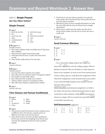
Bi-annual bike news from the City of Oakland, California, reporting on progress implementing Oakland’s Bicycle Plan.22nd Edition, Winter 2018 Circulation 3,168www.oaklandbikes.infoLet Us Count the WaysNearly eight miles (7.9) of new and improved bikeways were installedin neighborhoods east, west, north, and south between September andDecember 2017. Half of this increase was delivered by a citywide pavingcontract, funded by a combination of Measures B & BB, Local Streets andRoads, and State Vehicle Registration funding. (No bike-specific fundingsources were used—that’s your Complete Streets Policy in action, friends.)These newly paved bikeways include:98th Ave (Walnut St to Bancroft Ave): New bike lanes, 0.4 miles,included in the repaving project to calm traffic and improve safety forresidents and the school communities along 98th Ave.Adeline St (10th St to 19th St): New buffered bike lanes, 0.5 miles, thesecond segment of the Adeline St Bikeway to be constructed. (Bikelanes along the remaining sections of Adeline St were approved by CityCouncil in 2012 as part of the West Oakland Specific Plan.) Clay StFruitvale AveBroadway Ter (Broadway to Harbord Dr): New striped bikeway,0.8-miles, upgrading a signage-only route. The design includes mostlybuffered bike lanes, with a climbing bike lane and downhill sharrowswhere the road narrows between Carlton St and Broadway. This bikewayimproves access to the small commercial district at Clarewood Dr,improves pedestrian crossings, and calms traffic on a wide street.Clay St (7th St to 17th St): New buffered bike lanes, 0.5 miles,completing the north-south connection between the on-street Bay Trailat 2nd St (along Washington St) and the Telegraph Ave cycle track, andpassing downtown’s government buildings.Fruitvale Ave (Foothill Blvd to Harold St): We said it couldn’t be doneand that the sharrows installed in 2011 were the way to accommodatebicyclists along this important north-south corridor between theFruitvale and Dimond districts. We were wrong! One mile of bike lanewas installed in the uphill direction along Fruitvale Ave. In the downhilldirection, sharrows were reinstalled, centered in a 13’-wide travel lane.Market St (7th St to 18th St): Buffered bike lanes, 0.6 miles, wereinstalled, an upgrade from the bike lanes installed in June 2007. Look forfuture upgrades to the Market St bikeway.See pages 2-3 for nearlyfour miles of newUT WAIT! THERE’S MORE!bikeways delivered viastand-alone projects.This newsletter and the projects described herein are funded wholly or in part by Oakland’s share of Measure B and BB funds.Measures B and BB are Alameda County’s transportation sales taxes approved by voters in 2000 and expanded in 2014. Five percentof Measure B funds, and 8% of Measure BB funds, are dedicated to bicycle/pedestrian projects and programs throughout the county.For more information, see www2.oaklandnet.com/OAK022502.
10th St Bridge and UndercrossingOne of the last major projects in 2002’s voter-approved Measure DDbond measure, the 10th Street Bridge reconstruction was completed inDecember 2017 after a multi-year construction phase. The project replacedflow-restricting culverts with a clear span bridge and constructed apedestrian and bicycle path underneath, smoothly connecting Lake MerrittBlvd to Channel Park and the Laney College campus. The bridge includesbike lanes, pedestrian-scale lighting, and new sidewalks. Additional grantfunding came from the State Natural Resources Agency, California CoastalConservancy and Wildlife Conservation Board, and the East Bay MunicipalUtility District. A project to close the 10th St bikeway gap between 2nd and4th Aves and extend the bikeway east to 9th Ave is planned for 2018.Martin Luther King Jr Wy On the WayThese new bike lanes between W Grand Ave and 40th St wererecommended in the Martin Luther King Jr & Peralta Street Master Plan(2012). “Substantially completed” in December 2017 (the bike lane lines—but not the symbols—were painted), the 1.2-mile bikeway was installed viaconcurrent streetscape and paving projects. Additional heavy paving, nowunderway (photo, left), will retrofit the stretch betweem 32nd St and I-580.Bus bulb-outs, high-visibility crosswalks, and improved lighting were (arebeing) installed. There are now bike lanes on every major north-southstreet in North/West Oakland between Telegraph Ave and San Pablo Ave,all having been converted from four lanes to three lanes to make space for bicyclists, improve pedestrian safety, and reducespeeding. (Hip tip: on First Fridays skip the pedestrian snarl on Telegraph Ave and thecar congestion on Broadway by using these freshly paved bike lanes.)Upper Broadway: All Over But the ShoutingThe final major segment (Broadway Ter to Keith Ave) of the Broadway Bikewayproposed in the 2007 Bicycle Plan was completed in December 2017, funded by themitigation settlement from Caltrans’ Caldecott Tunnel Fourth Bore Project. In additionto badly needed repaving, the project removed travel lanes to make width for bike lanesand a center-left turn lane. Pedestrian safety improvements included high-visibilitycrosswalks, pedestrian count-down heads at Manila Ave, a “HAWK” (high-intensityactivated crosswalk) signal at Lawton St, and rectangular rapid flashing beacons at TaftAve. To the north, this 0.7-mile facility connects to the cycle track reported in the lastnewsletter, and at the southern end to the buffered bike lanes installed in September2014. This results in a pretty spiffy continuous three-mile bikeway between the NorthOakland Sports Center and 40th St. (The section between 40th St and W MacArthurBlvd along the Kaiser Hospital frontage is the weak link an otherwise continuousfacility that extends south into downtown.)RESOURCESPublic Works Call Center Via phone: (510) 615-5566 online:Suggest a Bike Rack Locationwww2.oaklandnet.com/ReportaProblem Review guidelines and either requestmobile: www.seeclickfix.com/oakland,a rack online or contact us (info onplease report:mailing panel). See4roadway glass, potholes, unsafewww.oaklandbikes.info/bikerack.drainage grates, or other obstructionsOakland’s Bicyclist and Pedestrian4 malfunctioning traffic signalsAdvisory Commission (BPAC)4 abandoned bikes that need removal from Meetings are held the 3rd Thursday ofbike racks, signs and/or meter polesthe month and are open to the public.4 speeding, or to request traffic calming orMore info at www.oaklandbikes.info/bpac.another roadway improvementIOA K L A N DWint er 2018Bicycle & Pedestrian Program Staff Jason Patton, Program Manager Matt Jones, Coordinator Jennifer Stanley, Coordinator David Pene, Assistant EngineerProgram Interns Joshua Ekstedt, Noel Pond-Danchik,Gregory Reft, Eric WilhelmVolunteersPeggy Mooney, Ronnie Spitzer, and . . . you?More info at www2.oaklandnet.com/bfvp.2
Peace Dividend Delivers BikewaysIn December, 1.8 miles of bikeways were completed as part of the redevelopment of the former Oakland Army Base. Thesite is located to the west of the West Oakland residential neighborhoods, roughly bounded by 7th St, W Grand Ave, and theapproach to the Bay Bridge. The redevelopment project includes a new multi-use path on Maritime St, the relocation of thepreviously constructed path along W Burma Rd, bike lanes on the length of the newly constructed E Burma Rd, and—still tocome—0.8 miles of bike lanes on the remaining length of W Burma Rd.The Oakland Army Base was a major west coast hub for shipping cargo in World War II and the Korean War, and forsending US soldiers to Viet Nam. Following the end of the Cold War, the base was closed and transferred to the City ofOakland for redevelopment. The new road infrastructure is being built for logistics facilities that will enable the transfer ofcargo from ship to rail to grow the Port’s capacity while reducing the reliance on trucking. Maritime St and W Burma Rd areboth part of the San Francisco Bay Trail that, at completion, will provide a 500-mile network of continuous paths and trailsaround San Francisco Bay, San Pablo Bay, and the Carquinez Strait.Oakland Learns to ShareVision HumansOaklanders now have over 800 shared bikes to ride with theinstallation of Ford GoBike stations starting in July 2017. As ofDecember, 72 stations were installed on streets, sidewalks andpublic plazas (see location map at www.fordgobike.com). FordGoBike (previously Bay Area Bike Share) is the San FranciscoBay Area’s regional bikeshare program, serving Oakland, SanFrancisco, San Jose, Emeryville, and Berkeley. Users can pick up abicycle at any self-serve station and return it to any other station.Bikes are placed at key destinations and regularly maintained,making it is especiallyuseful for people who areconcerned about storing abike, maintaining a bike, orhaving to lug a bike upstairsor on public transportation.A six-to-four lane road diet on Harrison St (WGrand Ave to 27th St), made room for a key bike laneconnection along two short high-traffic blocks justnorth of Lake Merritt where previously sharrowsmarked the outer travel lane. The Downtown SeniorCenter, Oakland’s largest and oldest senior facility, ison this block and there are schools and senior housingdevelopments in both directions. The project wasdesigned and constructed in 10 weeks in response toa pedestrian fatality at 23rd St. The redesign includeswider, more prominent crosswalks at all threeintersections, the addition of curb ramps to ensureaccessibility, advance stop lines at the signalizedintersections, and, approaching 27th St, the removalof one of two left turn pockets and the addition of aSince July, people inOakland have taken morethan 75,000 rides, withover 500,000 rides takenin the Bay Area, burning156 million calories in theprocess. Users can check out a Ford GoBike via any station’spayment kiosk, the Ford BoBike mobile app, or a with a Clippercard. The fare/usage structure includes options for single rides,and day or annual passes. Ford GoBike’s “Bike Share For All”program provides a one-time 5 annual membership for thoseBay Area residents aged 18 or older currently enrolled in theCalfresh or PG&E CARE programs. Users can sign up onlineat bikeshareforall.org or can pay in cash at the 19th Street andFruitvale BART Bike Stations. Staff from Bike East Bay, theScraper Bike Team, and Cycles of Change attended events aroundOakland to spread the word about bike share and bicycling whilesigning people up for discounted memberships.Partial funding for staff support was provided by theBay Area Air Quality Management District and theAlameda County Transportation Commission.IOA K L A N Dbicycle box. At 23rd St, purple painted bulbouts anda median were installed to reduce crossing distance,slow turning vehicles, and make pedestrians morevisible. (Planters may be added to the purple areas ifa maintenance partner is found.) Finally, the left turnfrom 23rd St, associated with the pedestrian fatality,was removed. Prior to the improvements, one out of10 motorists yielded to people in the crosswalks; afterimplementation, nine out of 10 drivers yielded. Here’s toprioritizing the safety of humans.Wint er 20183
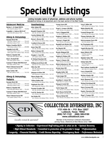
City of Oakland Bikeway Network2016Bikeway Improvements, July-December 20172017Bikeways Pending Construction, 2018BroadwayBroadway TerraceFruitvale AveMartin Luther King Jr WyNote: New paving between27th and 32nd Sts, andI-580 and W MacArthur Blvd.Paving underway between32nd St and I-580.Harrison St10th St UndercrossingMarket StBurma Rd Path10th St BridgeNote: Total reconstructionBurma Rd EastMaritime St Path98th AveAdeline StClay St- New Bike Path- New Bikeway Striping- New Bikeway Striping- Improved Bikeway Striping- Improved Bikeway Striping- New Paving- New PavingCompleted Bikeways (month year)Completed BikewaysBike Path(December(Class 1) 2017)Bike PathLane (Class(Class 1)2)Lane (ClassBike Class 3A)ArterialBoulevardBike ss3B)4)ProtectedBike Lane(ClassProtected BikewaysBike (all classes)See OaklandbikewayBikewaysclass definitionsatwww2.oaklandnet.com/OAK024595See Oakland bikeway class definitions atwww2.oaklandnet.com/OAK024595Bikeways,Adjacent JurisdictionsBikeways, AdjacentExisting JurisdictionsExistingProposed
Bicycling, briefly . . .Upgrading E 12th St Bike LanesWalk Oakland! Map & Guide, 6th EditionThe bike lanes striped on E 12th St (14 th Ave to Fruitvale Ave)in September 2014 were among the first buffered varietyinstalled by the City. Since then, Oakland’s design standardchanged to make buffered bike lanes more prominent.Changes include the addition of door zone buffer striping,conversion of the left-side bike lane stripe from skip tosolid, shortening the length of the right turn merge area, andwidening all bike lane stripes to 6” (some were 4”). At theend of 2017, the bikeway striping on E 12th St was upgradedto reflect the new standard. Upcoming: the AC Transit BusRapid Transit project will add bike lanes on E 12th St (2ndAve to 14 th Ave) and realign the eastbound segment east of14 th Ave, closing the current bike lane gap.The sixth edition of the Walk Oakland! Map & Guidewas released by publisher Rufus Graphics in October2017. In addition to pedestrian routes, paths, stairs, andkey destinations, the map shows bikeways throughoutOakland (those completed through June 2017 plus otherrecommended routes). The map was originally publishedin 2002 as part of the community outreach for the Cityof Oakland’s first Pedestrian Plan. Over the subsequenteditions, City staff have contributed updates and correctionsto help keep the map current. Go to www2.oaklandnet.com/OAK033011#mapsbyothers for a list of bike shops andbookstores throughout Oakland that carry the map.Putting in the RacksRight-Sized Racksfor Pint-SizedCyclistsA Measure DD-fundedproject to upgradeentrances to LakesidePark, Children’sFairyland, and theGarden Center isunderway. At the end of December, 10 new bikeracks were installed, flanking the entrance toFairyland, including four sized for the wee ones withwhom Fairyland is so popular.Like, New WayThe 3rd edition of the City of Oakland’s Guidelinesfor Bicycle Wayfinding Signage was published in September2017. The second edition (2011) added the section onConstruction Detours and made minor adjustments. Thisrevision was more substantial, changing the emphasis to localand nearby destinations, and adding 21 new destinations,including Oakland Public Libraries. The guidelines and a mapof supported destinations are at s Working TogetherIn September 2017, the City of Piedmont completed bicyclistand pedestrian improvements on Linda Ave, completing abikeway connection between the Grand Lake neighborhoodand the Piedmont Ave commercial district. The projectconstructed an uphill bike lane and made beautifulimprovements to two crosswalks at Beach ElementarySchool and Beach Play Field. The new bike lane establishesa continuous connection with bike lanes previously installedon Grand Ave (May 2016), Linda Ave in Oakland (February2017), and Piedmont Ave (November 2013).IOA K L A N DFrom July-December 2017, 140 new bikeparking spaces were installed via Oakland’sby-request CityRacks Bicycle ParkingProgram. This brings the total numberof rack spaces installed in 2017 (via CityRacks only)to 238—and the total number of publicly-accessiblebike parking spaces citywide to 9,900. The CityRacksProgram is fundedby grants from theTransportation Fundfor Clean Air, aprogram of the BayArea Air QualityManagement Districtadministered by theAlameda CountyTransportation Commission. Send location requests! Seewww2.oaklandnet.com/OAK024596#cityracks.Also notable, in December, the Capitol Corridor installed12 new eLockers at the Jack London Amtrak Station inDecember, bringing the total number of BikeLink lockersinstalled in Oakland to 414.The Oakland-to-Alameda ConnectionIn August, a City of Oakland project cleaned up the railroadcrossing, pavement, and bike lane striping on 23rd Avebetween Kennedy St and the Park St Bridge. In additionto paving and striping, the project constructed concreteislands, curb extensions, and lane channelizers to improvethe approaches of the intersecting roadways. New railroadwarning lights and signals will be added that will automaticallytrigger when an oncoming train arrives. Multiple projectsare under development to improve the bikeway connectionbetween the Park St Bridge and Jack London Square. For adetailed overview, see www2.oaklandnet.com/OAK067654.Wint er 20186
In October, staff kicked off the latest update to Oakland’s citywide bike plan, aka “Let’sBike Oakland.” Plan goals are to: update the existing Plan’s vision, goals, and policies witha focus on equity; engage Oaklanders and empower local community organizations to beleaders in this update; develop an action plan with performance measures for increasingthe number of people who bike, decreasing bicyclist crashes, and improving the quality ofbikeways to serve all ages and abilities. Since October, OakDOT: partnered with RideReport, a mobile application that tracks when and where youride your bike, and at the end of a bike trip, asks you to rate your ride. When cyclistsuse the app, the City gets direct feedback on where and when people feel comfortable riding (or not!). To participate,download RideReport at https://ride.report.conducted a citywide, statistically significant survey about biking in Oakland. The survey reached 800 respondents, andwas offered in English, Spanish, and Chinese. Key findings from the survey are: 24% of Oaklanders ride at least once amonth and 68% are very concerned about being in a bike crash. (A public version will be posted on the project websitein early 2018.)held a kick-off meeting for outreach with our community partners, Oakland-based organizations that will holdcommunity workshops and listening sessions this spring. We’re excited to work with these organizations, andencourage you to check out what they each do for Oakland: Bikes4Life, Cycles of Change, East Oakland Collective,Outdoor Afro, and The Scraper Bike Team.To get project updates and learn more about input opportunities go to letsbikeoakland.com.Zone Analysis for Bikeway PlanningOakland is a city of contrasts – by race and income, and also by geography:food culture amidst food deserts and tent cities within blocks of million-dollarbungalows. Oakland is flat and hilly. Downtown is central to just half of thecity; and 88% of Oakland’s BART stations are clustered in 34% of the City’sland area. To understand how we can most effectively serve Oaklanders, theBicycle and Pedestrian Program is analyzing the city as a collection of eightzones, defined primarily by topography and neighborhood identity.Why does this matter to bicycle planning? Citywide averages hide differences that are critical to understandingOakland.Analyzing data by geographical zone can bring these differences into focus.Because of the differences between zones, different zones will have different solutions.The Zone Analysis for Bikeway Planning helps visualize the differences across Oakland with the goal of shaping proposalsand investments that are responsive to the needs of different peoples and areas. The first version was released in November2017 and is available at www2.oaklandnet.com/OAK068239. The analysis will be expanded to include additional topicareas as new questions arise and new datasets become available.The current analysis includes maps and tables to communicate data in the following areas: Socioeconomics: race & ethnicity, income, age, disability, one parent households, rent burdened, language barriers, motorvehicle accessGeography: topography, proximity to downtown, proximity to BARTInfrastructure: pavement quality, bikeways, bicycle parkingBicycle Use: bicycling rates, crashes Work is currently underway to add analyses of the Bicyclist Level of Traffic Stress (LTS), BART station access data, and the“suitability” of Oakland’s streets for bicyclists by combining measures of traffic stress and street slope.IOA K L A N DWint er 20187
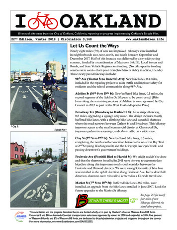
By the NumbersThis is the 14th installment of a feature to track progress implementing Oakland’s Bicycle Plan using themetrics in the table below. (For an explanation of these metrics, please see the Winter 2011 newsletter atwww2.oaklandnet.com/w/OAK026386.)Oakland Bicycle Facilities as of December 31, 2017IDate (as of)Bikeway milesBike parkingspacesBike wayfindingsign assembliesBike-friendlytraffic signalsDecember 31, 2007104.13,22400December 31, 2008106.53,492262December 31, 2009110.84,4282611December 31, 2010112.14,77212516December 31, 2011120.75,30320926December 31, 2012134.36,31534540December 31, 2013141.27,072415127December 31, 2014146.48,023476151December 31, 2015150.68,841518208December 31, 2016155.19,519571220December 31, 2017161.09,900571220OA K L A N DWint er 2018City of Oakland, Bicycle & Pedestrian ProgramOakland Department of Transportation, Safe Streets Division250 Frank Ogawa Plaza, Suite 4344Oakland, CA 94612Phone: (510) 238-3983Email: bikeped@oaklandnet.comWeb: www.oaklandbikes.infoSi desea un ejemplar del boletín del programaciclista de la Ciudad de Oakland en español, porfavor llame 238-3983 o OAK068478)(www2.oaklandnet.com/w/OAK068479)Union Bug #1PRINTED BYSEIUCITY OFOAKLANDMEMBERS LOCAL 1021(www2.oaklandnet.com/w/OAK068480)Union Bug #2PRINTED BYCITY OFSEIUMEMBERSOAKLANDLO CAL 10 21 Save a tree and all that. Switch to electronic-only newsletterdelivery. Email bikeped@oaklandnet.com to get stopped.8
activated crosswalk) signal at Lawton St, and rectangular rapid flashing beacons at Taft Ave. To the north, this 0.7-mile facility connects to the cycle track reported in the last newsletter, and at the southern end to the buffered bike lanes installed in September 2014. This results in a pretty spiffy continuous three-mile bikeway between the .