Transcription
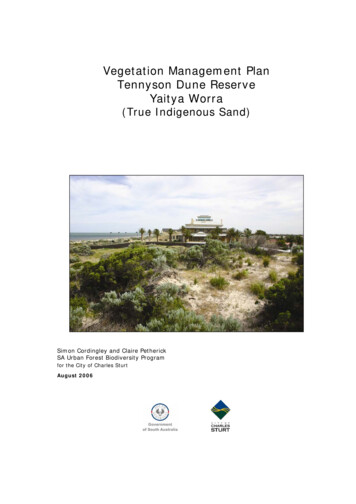
Vegetation Management PlanTennyson Dune ReserveYaitya Worra(True Indigenous Sand)Simon Cordingley and Claire PetherickSA Urban Forest Biodiversity Programfor the City of Charles SturtAugust 2006
VEGETATION MANAGEMENT PLAN, TENNYSON DUNE RESERVEThis Vegetation Management Plan is designed to be a flexible and dynamic document thatshould be adapted according to changes in the dune environment over time and as furtherinformation becomes available.This Vegetation Management Plan has been developed by the SA Urban Forest BiodiversityProgram (Department for Environment and Heritage) in partnership with the City of CharlesSturt as part of Planning SA’s Coast Park initiative.This report may be cited as:Cordingley, S. P. and Petherick, C. E., 2006, Vegetation Management Plan Tennyson Dune Reserve,Urban Forest Biodiversity Program, Adelaide.Information in this document may be copied provided that full acknowledgement is made.ii
VEGETATION MANAGEMENT PLAN, TENNYSON DUNE RESERVETABLE OF CONTENTS1. RESERVE IDENTIFICATION. 22. PURPOSE OF THE PLAN. 23. PLAN CONTEXT . 33.1 COAST PARK .33.2 MANAGEMENT PLANS .43.2.1 Adelaide Metropolitan Coast Park Concept Plan . 43.2.2 City of Charles Sturt Coastal Management Plan 2002-2007. 43.2.3 Adelaide’s Living Beaches – A Strategy for 2005-2025 . 64. BACKGROUND, HISTORY AND STATUS OF RESERVE. 74.1 PHYSICAL DESCRIPTION . 144.1.1 Topography/ Landform. 144.1.2 Soils. 144.1.3 Climate. 154.2 VEGETATION . 154.2.14.2.24.2.34.2.44.2.5Indigenous Vegetation . 15Plant Species Richness . 16Significant Flora . 17Significant Plant Communities . 17Condition . 184.3 FAUNA . 204.3.1 Native Fauna . 204.3.2 Introduced Fauna . 215. ADJOINING LAND USES AND VEGETATION . 216. RESERVE VALUES. 226.1 CONSERVATION VALUE . 226.2 EDUCATION VALUE . 226.3 AESTHETIC VALUE. 226.4 SCIENTIFIC VALUE . 226.5 OPEN SPACE VALUE. 237. RESERVE MANAGEMENT OBJECTIVES . 238. NATIVE VEGETATION MANAGEMENT ISSUES . 248.1 WHOLE RESERVE MANAGEMENT ISSUES . 248.1.18.1.28.1.38.1.48.1.58.1.6Fragmentation . 24Weeds . 25Fire . 34Access and Fencing . 34Erosion . 37Introduced Fauna . agementManagementManagement8.2 MANAGEMENT ISSUES AND STRATEGIES WITHIN EACH MANAGEMENT ZONE . 41Zone 1 - Foredune . 41Zone 2 – Interdune Swale. 44Zones 3a and 3b – Hind Dune Seaward Face . 48Zones 4a and 4b – Hind Dune Ridge. 54Zone 5 - Rehabilitation . 599. SUMMARY OF MANAGEMENT RECOMMENDATIONS/SUGGESTIONS. 6410. IMPLEMENTATION SCHEDULE AND APPROXIMATE BUDGETS . 68GLOSSARY . 74REFERENCES . 76iii
VEGETATION MANAGEMENT PLAN, TENNYSON DUNE RESERVEAPPENDIX 1: CONTEXT . 80INTERNATIONAL . 80NATIONAL . 80Coastal Zone Inquiry .81Australian Coastal Policy .81Coast and Clean Seas .82STATE . 82REGIONAL . 83Adelaide and Mount Lofty Ranges .83SA Urban Forest Biodiversity Program .86ADELAIDE METROPOLITAN COAST . 86Coast Protection Board .87Coast Park .87LOCAL . 87Local Government .87Community Groups .88APPENDIX 2: PLANT SPECIES LIST FOR TENNYSON DUNE RESERVE . 90APPENDIX 3: PRIORITY WEED SPECIES . 93APPENDIX 4: WEEDING CALENDER . 121APPENDIX 5: COMMON WEED REMOVAL TECHNIQUES . 122APPENDIX 6: BUSHLAND WEEDING CODE . 124APPENDIX 7: COASTAL INDIGENOUS SPECIES . 125APPENDIX 8: PRIORITY ACTIONS FOR INDIGENOUS SPECIES WITHINTENNYSON DUNE RESERVE. 157APPENDIX 9: SEED COLLECTION TECHNIQUES AND PROPAGATION METHODS. 163COLLECTION OF NATIVE PLANT MATERIALS . 163APPENDIX 10: REVEGETATION METHODS. 165REVEGETATION OBJECTIVES . 165USING LOCALLY INDIGENOUS SPECIES . 165WHAT TO PLANT WHERE?. 166PLANTING TUBE-STOCK . 166APPENDIX 11: REVEGETATION IMPLEMENTATION SCHEDULE (2007-2011). 168iv
VEGETATION MANAGEMENT PLAN, TENNYSON DUNE RESERVEAcknowledgementsThank you to everyone who has assisted with the preparation of this Management Plan. Yourtime and resources were greatly appreciated. Special thanks need to be made to RonSandercock (Coastal Protection Branch, Department for Environment and Heritage) and AmyBruckman (SA Urban Forest Biodiversity Program) for their efforts in bringing this documentto fruition.GIS AND COMPUTER SUPPORTDarcy Peters (SA Urban Forest Biodiversity Program)BOTANICSJamie Mugridge (Indigeflora)Ron Sandercock (Coastal Protection Branch, Department for Environment and Heritage)HISTORY AND RESERVE STATUSStephen Cox (Coastal Protection Branch, Department for Environment and Heritage)Nick Crouch (Henley and Grange Dunecare)Christopher Naylor (Local Resident)Ron Sandercock (Coastal Protection Branch, Department for Environment and Heritage)PHOTOGRAPHSAll photographs, except where noted are by Simon CordingleyDoug Fotheringham (Coastal Protection Branch, Department for Environment and Heritage)Vicki Hagan (Bush A-new)Ben Moulton (SA Urban Forest Biodiversity Program)Ron Sandercock (Coastal Protection Branch, Department for Environment and Heritage)Michael Smith (Local Resident)GENERALAmy Bruckman (SA Urban Forest Biodiversity Program)Angela Carson (City of Charles Sturt)Brian Caton (Member South Australian Coast Protection Board)Nick Crouch (Henley and Grange Dunecare)Combined Coastal Groups of the City of Charles SturtCommunity Coastal Reference Group, City of Charles SturtSharon Gardner (City of Charles Sturt)Angela Loram (SA Urban Forest Biodiversity Program)Rata Luckens (City of Charles Sturt)Wendy McFadyen (City of Charles Sturt)Mark Mobbs Planning SA)Ben Moulton (SA Urban Forest Biodiversity Program)Ross Oke (SA Urban Forest Biodiversity Program)Renz Piovesan (City of Charles Sturt)Ron Sandercock (Coastal Protection Branch, Department for Environment and Heritage)Jenny Watson (City of Charles Sturt)v
VEGETATION MANAGEMENT PLAN, TENNYSON DUNE RESERVESource: Department for Environment and Heritage1
VEGETATION MANAGEMENT PLAN, TENNYSON DUNE RESERVE1. Reserve IdentificationReserve Name:Tennyson Dune ReserveLocal Government Area: City of Charles SturtLocation:The study area extends northward from BournemouthAvenue, Tennyson to Cormorant Court, West Lakes Shore.The eastern boundary is marked by Military Road andresidential boundaries. The western boundary is the highwatermark. The Reserve location is shown in Figure 1.Area:20.5haReserve Status:Tennyson Dune Reserve is divided into eight allotments andhas several owners and managers, as summarised in Table /managers’.Table 1: Land Ownership and Management Bodies of Tennyson Dune ReserveOwnerUnallotted Crown LandFreehold title by Coastal Protection BoardCrown record dedicated to the Coastal Protection BoardFreehold title by the City of Charles SturtLand ManagerLand Administration BranchCoast Protection BranchCoast Protection BranchCity of Charles Sturt2. Purpose of the PlanWithin the City of Charles Sturt there are a number of management issues whichthreaten the integrity of the region’s coastal native vegetation. These issues have beenidentified as weed and pest animal invasion, pedestrian access, stormwater discharge,erosion and fire. A coordinated approach to management is crucial to prevent furtherdegradation and to enhance the natural biodiversity of these fragile coastalenvironments.Within this context, the City of Charles Sturt has identified the need to produce a seriesof practical, issue specific, management plans to guide the implementation of nativevegetation enhancement works within the dune system.General public consensus is that Tennyson Dune Reserve is classified as a CouncilReserve. For the most part, this is not the case and its care and control has been ashared responsibility of the governing bodies mentioned in Table 1. This Plan attempts toreflect this relationship and has been a collaborative effort between the StateGovernment, City of Charles Sturt and local community groups.This plan features: Site and vegetation community descriptions, including species lists and aerialvegetation maps A weed control plan that includes a list of priority weed species, weed distributionmaps and weed control methodology A revegetation plan detailing a list of suitable species, quantities required andrevegetation methodology Recommendations for addressing native vegetation management issues includingfire, access and fencing, erosion, introduced fauna and stormwater outfall areas2
VEGETATION MANAGEMENT PLAN, TENNYSON DUNE RESERVE Provision of background information, including history, current status and possiblefuture sand management strategies Identification of opportunities for educational activities and signage A timetable for plan implementation with approximate budgets Detailed on-ground focussed appendices to guide in the implementation of theManagement Plan recommendations.The target audience for this plan includes State Government land owners, Local Councilstaff, contractors, community groups such as Coastcare/Dunecare groups and localschools and residents who may play a role in the management of this section of coast. Itis intended that this plan provides the framework for a coordinated rehabilitationprogram for the above-mentioned groups. The plan will help optimise the success of onground works within the dune system from a native vegetation perspective.3. Plan ContextThis plan seeks to address numerous coastal management issues identified in theAdelaide Metropolitan Coast Park Concept Plan (PPK, 2001) and the City of Charles SturtCoastal Management Plan 2002 – 2007 (Kinhill, 1999).3.1 Coast ParkDelivered through Planning SA, the Adelaide Metropolitan Coast Park is a StateGovernment initiative involving partnerships with other State Government agencies,Local Councils and key stakeholder groups. Essentially, Coast Park is a linear parkextending approximately 70km along the Adelaide metropolitan coastline, from SellicksBeach to North Haven. It will link key interest areas to provide a publicly accessible linearpark along the length of the metropolitan coast. Coast Park will link with the RiverTorrens Linear Park, as well as other linear parks in metropolitan Adelaide.Sections completed to date (May 2006) include the coastal walking trail at Marino/HallettCove Conservation Parks, as well as shared-use paths (providing access for pedestrians,cyclists and people with disabilities) at: North and South Esplanades, Glenelg Esplanade at South Brighton and Seacliff West Beach Dunes at Adelaide Shores Coastal strip from Semaphore South through to Taperoo Esplanade, Christies Beach. Ozone Street Carpark, Henley Beach South to Henley Sailing Club, West Beach.As part of the Coast Park initiative, a series of coastal Vegetation Management Plans arebeing produced by the SA Urban Forest Biodiversity Program (UFBP). Planning SA hasmade funds available to the City of Charles Sturt for the production of a series of fourVegetation Management Plans (consistent with other plans developed by UFBP) for thecoastal strip between Chetwynd Street, West Beach and Bower Road, Semaphore Park.This plan is the third in the series. Vegetation Management Plans completed to date are:3
VEGETATION MANAGEMENT PLAN, TENNYSON DUNE RESERVE Henley South and West Beach Dune Reserve (May 2005) Henley Beach to Tennyson Coastal Reserve (January 2006).In addition, Coast Park funding is enabling the provision of technical advice andassistance to land managers to ensure these plans are implemented.3.2 Management PlansSeveral planning documents exist that provide context and direction on the managementof this Reserve.3.2.1 Adelaide Metropolitan Coast Park Concept PlanThe Adelaide Metropolitan Coast Park Concept Plan (PPK, 2001) sets out a number ofpossible strategies and recommended actions for the Coast Park over a ten-year timeframe. The Coast Park vision is to:‘Revitalise and sustain a healthy, diverse and accessible Coast Park to be enjoyed andvalued by present and future generations’.The goals of this initiative are to: Maintain and enhance open space linkages ensuring free, safe and convenientaccess facilities are available for all ages and abilities Recognise, value and reinforce the diversity of the coastline, ensuringdevelopment takes place in appropriate locations and that social, economic andenvironmental values are achieved Provide appropriately for traffic and parking, ensuring convenient access forpeople wishing to use the coast, taking into account the need for safety forpedestrians and cyclists Recognise, value, protect and where possible, enhance sandy beaches, seagrassbeds, remnant dunes, coastal reserves and buffers, and water quality along thecoast Pursue every opportunity to educate the community and decision makers on thevision for, and the special value of the coast, and lessons learnt about themanagement of our coastline.The Concept Plan identifies pressures on Tennyson Dune Reserve as pedestrian access,erosion, the introduction of pest flora and fauna and subsequent pressure on remnantvegetation. The Concept Plan also outlines strategies and responses to these pressuressuch as controlling access to the dunes, identifying, protecting and enhancing areas ofsignificant vegetation and undertaking a weed and feral animal control program.3.2.2 City of Charles Sturt Coastal Management Plan 2002 - 2007The City of Charles Sturt Coastal Management Plan encompasses the Council’s coastalregion, stretching southwards from the City of Port Adelaide Enfield boundary at BowerRoad to the Adelaide Shores Caravan Park (Kinhill Pty Ltd, 1999). The Plan wasdeveloped by Council in response to community concerns about a range of environmentaland social issues within the coastal zone and a mutual desire for the sustainable use ofcommon coastal resources.The key purpose of the Coastal Management Plan is to provide Council with a moreaccurate decision making process for the allocation of resources. It is acknowledged that4
VEGETATION MANAGEMENT PLAN, TENNYSON DUNE RESERVEthe Plan operates within broader policy frameworks (i.e. the Corporate Plan and theMetropolitan Planning Strategy) and as such is not considered a strategic document.The aims of the Coastal Management Plan are to: Identify environmental and coastal management issues in the City of Charles Sturtcoastal area, for the purpose of creating a prioritised action plan for the future; Ensure sustainable resource usage and resource conservation taking intoconsideration the physical, environmental, economic, social, historical, recreationaland cultural attributes of the coastal zone (Kinhill, 1999).Through the Coastal Management Plan, Council, in consultation with an array of keystakeholder groups and individuals, identified four key management areas and associatedgoal as summarised in Table 2.Table 2: Key Management Areas and Goals of the City of Charles Sturt’s Coastal Management PlanKey Management AreasAccessActivitiesConservationCoastal ProcessesGoalsProvision of a formal network of roads, shared-use paths, beach accesspaths, ramps and corresponding support facilities that allow safe access forcyclists, pedestrians, vehicles and boats, (including disabled and all agesaccess where appropriate).A diverse and well managed range of recreational and cultural activities,with minimal impact on other coastal users and that protect and/or enhancethe coastal and marine environments.Ensure biological, social, cultural and heritage values are identified,protected and promoted to enhance biodiversity, coastal amenity, coastalcharacter appreciation and visitor experiences.Pre-emptive management of natural and accelerated coastal processes.These key areas were investigated further and a series of detailed management aspectsand strategies identified under each of these categories. These management aspects are(in no specific order of importance): Beach and water pollution/monitoring Capital works (timing) Cycling (access and safety) General patterns of development Linkages between areas Maintenance Public safety Sand dune protection Sand movement and replenishment Stormwater runoff and pollution.These management aspects and consequent detailed management strategies are theprimary focus of the City of Charles Sturt Coastal Management Plan.The Plan makes the following comments concerning the Tennyson Dunes: ‘ extensive areas of biologically important remnant sand dune found in thevicinity of Estcourt House makes conservation a management priority in thissection’ (Section 2.3) ‘Focus revegetation works on priority areas of sand depletion or vulnerablehabitat, particularly Tennyson Dunes’ (Section 4.3).5
VEGETATION MANAGEMENT PLAN, TENNYSON DUNE RESERVEIn addition to these specific actions, it was recommended that the Management Plan bereviewed on an ongoing basis and the strong communication and coordinating linkbetween Council and those with an active interest in the coast be maintained. As a result,a major recommendation included the establishment of a Community Coastal ReferenceGroup to provide Council with feedback and assistance in the implementation of the Plan.This group began operation in May 2003 and consists of several communityrepresentatives, elected members, Council staff and a member of the Coastal ProtectionBranch.The City of Charles Sturt Coastal Management Plan (Kinhill Pty Ltd, 1999) was adoptedby Council in April 2002 with support for its implementation provided through itsoperating budget. External funding through NHT-Coastcare (Phase 1), Coastal ProtectionBranch Metropolitan Coastal Works, Coastal Protection Branch Small Participation Grantsand the SA Urban Forest’s Million Trees Program has been provided to assist in itsimplementation (refer to Appendix 1).3.2.3 Adelaide’s Living Beaches – A Strategy for 2005-2025In 2000 the Department for Environment and Heritage, initiated a review of themanagement of Adelaide’s Metropolitan coastline on behalf of the Coast Protection Board.This strategy supersedes the previous Report of the Review of the Management ofAdelaide Metropolitan Beaches, 1997. Released in June 2005, it contains the CoastProtection Board’s vision for the next 20 years.The strategy identifies and addresses the issues of dwindling local sand sources, seagrassloss, rising sea levels and the need to bypass sand around the harbours of HoldfastShores and Adelaide Shores.The strategy has five main components:1. Continue beach replenishment2. Recycle sand more effectively using sand slurry pumping and pipelines3. Add course sand from external sources4. Build coastal structures in critical locations5. Integrate sand bypassing at harbours with beach management.It is important to note the following additional aims of the strategy with regards toimplications for dune biodiversity and management: Trial sand slurry pumping methods and investigate how pipelines can be installedunobtrusively behind dunes and at the top of sea walls. Maintain necessary sand dune buffer along the metropolitan coast to provideprotection for two 1-in-100-year average return interval storms, with an allowanceover time for one metre of sea level rise as a consequence of climate change. Thisis in accordance with Coast Protection Board policy and provides for a dry sandybeach amenity above high tide. Sand dune volumes and beach widths are used asmanagement performance indicators. Redistribute the existing sand dune supplies that have built up over the last halfcentury in order to protect development and maintain beach width from KingstonPark to North Haven. Educate the community on the value of recently created dunes as primarily asource of sand to provide protection and beach amenity rather than forconservation of biodiversity. The dunes need to be vegetated to prevent sand drift6
VEGETATION MANAGEMENT PLAN, TENNYSON DUNE RESERVEand this provides a secondary benefit as habitat for birds and animals. Even so, itmust be recognised that the dunes could be eroded away in a storm event. Incontrast, the Tennyson and Minda dunes are remnants of the original Adelaidecoastal dune field and will be preserved and restored accordingly. Nativevegetation at these and other locations will be managed according to current bestpractice and in line with management plans being prepared in conjunction withlocal councils.Appendix 1 provides information on the international, national, state, regional and localcontexts in which this plan has been written and will be implemented.4. Background, History and Status of Reserve‘The tallest of the sandhills are near Estcourt House between the Semaphore and the Grange, theheight probably reaching to about 50 feet. The breadth of the sandhills is only a few hundred yards. Onthe sea-front is a sharp rise immediately eastward of the highest tidal limits. This is followed by ashallow depression (swale) and then usually by the highest part of the dunes, with a fairly sharpdescent on the landward sides, or there may be three rises altogether and two swales. In places thesandhills are bare and of shifting dazzling white sand, but for the most part, except on the actualseafront, they are covered with a vegetation of their own.’ (Cleland, 1932)The aim of this particular section is to provide a history and status of Tennyson DuneReserve within the broader context of a dramatically altered metropolitan coastline.Accent will be upon how urban development has affected natural systems along the coastand how this development influences current management practices.Pre-European HistoryPrior to European settlement in 1836, Adelaide’s metropolitan coastline consisted of analmost uninterrupted 30km stretch of sand dunes, running from Seacliff in the south toOuter Harbour in the north. This dune system ranged between 200 and 300m in widthand up to 10-15m in height. Generally characterised by several parallel ridges withnarrow, often wet, swales in between, the dunes were home to a diverse array of floraand fauna. Very little of these original metropolitan dunes remain, notably only atTennyson and a small section at North Brighton. Immediately behind these dunes were aseries of freshwater wetlands affected by occasional tidal incursions. These freshwaterswamps and lagoons stretched from Kingston Park in the south to the Port River in thenorth (Kraehenbuehl, 1996). They contained very different flora and fauna communitiesto those represented within the dune system proper.The area along Adelaide’s coast was originally inhabited by the Kaurna people. Prior totheir dispossession shortly after European settlement, they were accustomed to movingseasonally between the foothills in winter and the coast during warmer months.The Kaurna name for the land stretching roughly from West Lakes to Gillman is YertaBulti (Land of Sleep or Death). Yaitya Worra is the modern Kaurna name for theTennyson Dunes, meaning literally, ‘true indigenous sand’ (Kaurna Warra Pintyandi,2006).The Port Adelaide Kaurna people lived among the abundant resources the coastalenvironment provided. These included fish, shellfish, crustaceans, birds and native flax,which was essential for making mats, baskets clothing and nets used in the hunting largegame birds and fish (Wanganeen et al, 1996).As the Kaurna people favoured campsites
VEGETATION MANAGEMENT PLAN, TENNYSON DUNE RESERVE 4 Henley South and West Beach Dune Reserve (May 2005) Henley Beach to Tennyson Coastal Reserve (January 2006). In addition, Coast Park funding is enabling the provision of technical advice and assistance to land managers to ensure these plans are implemented. 3.2 Management Plans
