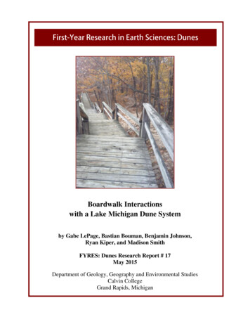
Transcription
North Carolina Sea Grant, September 2003Please save, share or recycle
T A B L EDunesO FC O N T E N T SChapter 1: Introduction . . . . . . . . . . . . . . . . . . . . . . . . . . . . . . . . . . . . . . . . . . .2What is a Dune? . . . . . . . . . . . . . . . . . . . . . . . . . . . . . . . . . . . . . . . . . . . . . . . . . . . . .2Chapter 2: How the Beach Works . . . . . . . . . . . . . . . . . . . . . . . . . . . . . . . . . . . .3Beach Shape . . . . . . . . . . . . . . . . . . . . . . . . . . . . . . . . . . . . . . . . . . . . . . . . . . . . . . . .4Chapter 3: Erosion Types . . . . . . . . . . . . . . . . . . . . . . . . . . . . . . . . . . . . . . . . . .5Seasonal Fluctuations . . . . . . . . . . . . . . . . . . . . . . . . . . . . . . . . . . . . . . . . . . . . . . . . .5Storm-Induced Erosion . . . . . . . . . . . . . . . . . . . . . . . . . . . . . . . . . . . . . . . . . . . . . . . .6Post-Storm Recovery . . . . . . . . . . . . . . . . . . . . . . . . . . . . . . . . . . . . . . . . . . . . . .7Long-Term Erosion . . . . . . . . . . . . . . . . . . . . . . . . . . . . . . . . . . . . . . . . . . . . . . . . . . .8Inlet Erosion . . . . . . . . . . . . . . . . . . . . . . . . . . . . . . . . . . . . . . . . . . . . . . . . . . . . . . . .9Science Versus Myth: Do Dunes Help Stop Long-Term Erosion? . . . . . . . . . . . . . . . .9Chapter 4: Dune Vegetation . . . . . . . . . . . . . . . . . . . . . . . . . . . . . . . . . . . . . . . . . . .11Influence of Climate . . . . . . . . . . . . . . . . . . . . . . . . . . . . . . . . . . . . . . . . . . . . . . . . .12Dune Plant Species . . . . . . . . . . . . . . . . . . . . . . . . . . . . . . . . . . . . . . . . . . . . . . . . . .12Sea Oats . . . . . . . . . . . . . . . . . . . . . . . . . . . . . . . . . . . . . . . . . . . . . . . . . . . . . . .12American Beachgrass . . . . . . . . . . . . . . . . . . . . . . . . . . . . . . . . . . . . . . . . . . . . .13Bitter Panicum . . . . . . . . . . . . . . . . . . . . . . . . . . . . . . . . . . . . . . . . . . . . . . . . . .14Saltmeadow Cordgrass . . . . . . . . . . . . . . . . . . . . . . . . . . . . . . . . . . . . . . . . . . . .14Seashore Elder . . . . . . . . . . . . . . . . . . . . . . . . . . . . . . . . . . . . . . . . . . . . . . . . . .15Fertilizing Tips . . . . . . . . . . . . . . . . . . . . . . . . . . . . . . . . . . . . . . . . . . . . . . . . . . . . .15Fertilizer and Irrigation . . . . . . . . . . . . . . . . . . . . . . . . . . . . . . . . . . . . . . . . . . . . . .16Other Planting Suggestions . . . . . . . . . . . . . . . . . . . . . . . . . . . . . . . . . . . . . . . . . . .16Dune Plant Communities . . . . . . . . . . . . . . . . . . . . . . . . . . . . . . . . . . . . . . . . . . . . .16Science Versus Myth: Do Dune Plants Stop Erosion? . . . . . . . . . . . . . . . . . . . . . . . .17Natural Dune Recovery . . . . . . . . . . . . . . . . . . . . . . . . . . . . . . . . . . . . . . . . . . . . . . .17Chapter 5: Dune Management Practices . . . . . . . . . . . . . . . . . . . . . . . . . . . . . . . . . .20Plant Spacing Guidelines . . . . . . . . . . . . . . . . . . . . . . . . . . . . . . . . . . . . . . . . . . . . .20Sand Fences . . . . . . . . . . . . . . . . . . . . . . . . . . . . . . . . . . . . . . . . . . . . . . . . . . . . . . .21Advantages of Fencing . . . . . . . . . . . . . . . . . . . . . . . . . . . . . . . . . . . . . . . . . . . .23Rope Fencing . . . . . . . . . . . . . . . . . . . . . . . . . . . . . . . . . . . . . . . . . . . . . . . . . . . . . .23Christmas Trees . . . . . . . . . . . . . . . . . . . . . . . . . . . . . . . . . . . . . . . . . . . . . . . . . . . . .23Protecting Beach Accessways . . . . . . . . . . . . . . . . . . . . . . . . . . . . . . . . . . . . . . . . . .24Vehicular Ramps . . . . . . . . . . . . . . . . . . . . . . . . . . . . . . . . . . . . . . . . . . . . . . . . . . . .25Science Versus Myth: Is Beach Scraping Useful for Building Dunes? . . . . . . . . . . . .25Permits . . . . . . . . . . . . . . . . . . . . . . . . . . . . . . . . . . . . . . . . . . . . . . . . . . . . . . . . . . .26Chapter 6: Summary . . . . . . . . . . . . . . . . . . . . . . . . . . . . . . . . . . . . . . . . . . . . . . . .27Related Reading . . . . . . . . . . . . . . . . . . . . . . . . . . . . . . . . . . . . . . . . . . . . . . . . . . . .28Glossary . . . . . . . . . . . . . . . . . . . . . . . . . . . . . . . . . . . . . . . . . . . . . . . . . . . . . . . . . .281
Chapter 1Chapter 1:Introductionshoreline where people, buildings and roads are alreadyin place. However, the practices are not intended to beapplied to undeveloped shorelines where wildlife ornatural area management is the primary goal. In areaswhere the dunes and dune vegetation interact with otherinland grasses, trees and shrubs, different managementapproaches may be needed.Thirty years ago, sand dunes and dune vegetationoften were considered nuisances to be flattened beforestarting coastal development. Fortunately, times havechanged. Dune vegetation is now recognized as an important asset for providing protection from natural hazardsand aesthetic benefits. Although property owners andcommunities are doing a much better job of protecting thedunes, the functions, benefits and limitations of dunes areoften misunderstood.This booklet will describe what dunes and dunevegetation can and cannot do, cutting through some ofthe well-established myths. We will discuss how naturebuilds and destroys dunes and why they are so important.We will look at how we can manipulate the naturalprocesses for the better and sometimes, if we are notcareful, for the worse. The best dune grasses for the NorthCarolina coast are described and tips are given on how toplant and grow them. We also will discuss the best waysto use sand fences and other sand traps.We will give the reader a general view of the bestdune management practices along developed shorelines.The booklet includes plant species, common developmentpractices and regulations in North Carolina. The generalmanagement approaches will apply on any developedWhat Is a Dune?Ocean sand dunes are geologic features that are ina constant state of change — somewhere between buildingin elevation with wind-trapped sand and getting flattenedin an extreme storm or hurricane. Attempts to definea dune for regulatory purposes have proven quite difficultdue to the wide range of evolving features.In this booklet, we will take the broadest view.Dunes are defined as any area landward of the activebeach where dune grasses are the dominant plants. Itmight be a classic dune shape that rises 40 feet in heightand is covered with sea oats, a recent overwash terraceflattened by a hurricane where the buried dune grasseshave yet to pop up through the new sand, or anywherein between.2
Chapter 2Chapter 2:How the Beach WorksTo understand the dunes, you must first understandhow the beach works.Ocean waves dominate the beach. Waves absorbenergy from the wind. Stronger winds and larger stormscreate larger waves. That energy is transmitted across thewater surface by the waves to the coast where the wavesbreak, unleashing that energy on the beach. Wave forcesare very misleading. Most people avoid hurricane windsof 120 miles per hour. Yet the force of a single 2-footwave breaking on a solid, vertical wall is at least threetimes more powerful than the winds of a major hurricane.Fortunately, our relatively thin bodies let the forces goaround us, allowing people to play in the surf.The most important protective feature of the beachand dune system is the submerged offshore slope. As awave moves into shallower water, friction-like factorsinternally affect the wave form, slowing the base of thewave but having less effect on the crest or top of thewave. The decreasing depth causes the wave to increasein height, slow in speed and become much steeper. Atsome point, the crest of the wave is moving too fast forthe bottom of the wave form to keep up. Then the wavebecomes unstable and breaks, dissipating part of its energybefore reforming into a smaller wave.This depth-induced breaking is a relatively predictablewave phenomenon that can be measured on any beach orreproduced in the laboratory wave tank. This descriptionassumes the wave will break when the water depth isroughly equal to the wave height. More precisely, the wavesbreak when the wave height (crest to trough distance) isabout 78 percent of the water depth, as shown in Figure A.Storm winds blowing across large ocean areas cangenerate very large waves. Waves taller than 40 feethave been measured in deep water off the North Carolinacoast during passing hurricanes. One of the largestwaves ever measured was a height of 112 feet duringa Pacific typhoon.Photo 1: Wave height is easiest to observe on fishing piers.Just one of these large waves would be devastatingfor houses and other development near the coast.Fortunately, our relatively flat continental shelf providesprotection from the largest waves. A 40-foot wave willbreak in roughly 40 feet of water several miles offshore,even in the middle of a hurricane. This breaking effect willoccur repeatedly as the wave approaches the beach. By thetime the waves get to buildings on the shoreline, they areusually smaller than 6 feet, even in a hurricane. Therefore,the offshore slope protects the beach and any coastal development from the largest waves.A good place to observe wave effects is on a fishingpier (Photo 1). During a small storm, the seaward endof the pier may get 6- to 10-foot waves. To estimate thewave height, look at the pier pilings, following the waves tothe beach where you can see them break once or twicebefore finally running up the beach face. At low tide, thelast wave break may only be a foot or two in height.0.78 x d wave heightwater levelwater depth (d)Water Depth Controls Wave HeightFigure A: Maximum wave height is controlled by water depth. Shallow water causes the wave to break.3
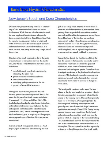
H O WDunesT H EB E A C HW O R K SThe sand’s grain size varies with location acrossthe beach profile. The finest sands are in the dunesand farther offshore in deep water. The sands in theberm and beachface are coarser, with the coarsestfound under the break point at the bottom of thebeachface. On any individual beach, the grain sizedistributions are relatively constant — but can changesignificantly from beach to beach. Fine sands resultin flatter beaches. Coarse sand results in a steeperbeachface. Variations in sand size occur due to thesource of the sand, most often resulting from theunderlying or adjacent geology that is being reworkedby the waves.If ocean conditions were ever constant, theshape of the beach would approach a relativelyconstant or equilibrium shape. In nature, wave heightand water level are constantly changing. The tide isrising and falling. Changing wind conditions areconstantly varying the wave height. The shape of thebeach cannot reach equilibrium, but it continues tomove toward that shape for the present conditions.The adjustments in the beach shape are critical inproviding storm protection for coastal developmentand are second in importance to the wave protectionprovided by the offshore slope.Beach ShapeThe shape of the beach is no accident. It isrearranged constantly by changes in the waves. Figure Bshows the primary parts of the beach. The dune is thevegetated area. The berm is the dry, sandy beach whereyou can place your beach blanket. The beachface is thesteeper sloped area leading to the water, where the wavesare constantly running up. The offshore underwater areais in constant motion also extending at times to deeperthan 30 feet and more than a mile offshore.The primary factors that affect the beach shape onmost days are: the wave height during the last week or so; the water level, including astronomical tide conditionsand recent storm surges; and the grain size of the sand.Higher waves shift sand from the berm into deeperwater, flattening the beachface. Smaller waves move sandback to the berm and steepen the beachface.When higher astronomical tides or small stormsurges raise the water level, smaller waves can causeas much erosion as larger waves at normal water levels.Wider tide ranges tend to create flatter beachfaces.Areas with small or no astronomical tides tend to havesteeper and shorter beachfaces.Vegetation lineDuneBeachfaceBermOffshoreBeach ProfileFigure B: Beach components are illustrated above.4
Chapter 3Chapter 3:Erosion TypesBeaches are products of erosion. They exist becauseof the erosion and recovery of sand as the shorelinesadjust to the forces that shape them. There are manylevels and causes of erosion. To help people understanderosion, it is separated into four types or causes: seasonalfluctuations, storm-induced erosion, long-term erosionand inlet erosion. To make the best dune managementdecisions, it is critical to understand what type or typesof erosion are occurring. Building dunes and plantingvegetation can be very effective in treating some typesof erosion but totally ineffective for others.Seasonal FluctuationsPhoto 2: The vegetation line is established by seasonalfluctuations.Dune grasses grow into the berm all summer.However, during the stormy season, wave-induced erosionreaches the vegetation, undermining plants that are tryingto grow farther seaward (Photo 2). Therefore, the vegetation line represents the landward limit of wave-inducederosion during the last one or two storm seasons.On summer days, it is hard to imagine that theberm is temporarily eroded almost every year. On a typicalNorth Carolina beach, the waterline moves about 75 to100 feet every year due to seasonal fluctuations. Seasonalfluctuations also cause dramatic changes in the elevationof the beach. When most beaches are at the widest,usually in the summer, you can stand at the seaward edgeof the berm at the top of the beachface, and the beachelevation under your feet typically had been 6 to 8 feetlower following the worst storms of the previous year.Although relatively large in scale, the seasonal fluctuations in the beach width are usually not considered tobe erosion. As long as the sand returns for the summer, noone usually worries about the few days when the bermdisappears, and waves cut to the vegetation line. However,understanding the seasonal loss helps homeowners determine where dune building is likely to be successful. Theberm seaward of the vegetation line is controlled by thewater and the waves. Later in the book, there is a sectionon how winds affect dunes. When the competing forces ofwater and wind reshape the beach, the water always wins,Varying weather and storm patterns that reoccurevery year cause seasonal fluctuations in the beach width.Between late fall and early spring, a series of storms withhigher velocity winds from the northeast or “northeasters”occur across the North Carolina coast. These massiveoffshore storms cause larger waves and small storm surgesthat — at least on east-facing beaches — erode the berm.Although no single storm may be particularly noteworthy,they come frequently enough that the berm does not havetime to recover during the periods of smaller waves thatoccur between storms. In contrast, the summer season hasfewer and smaller storms, and the berm is usually widerthan during late fall to early spring.Because most visitors usually go to the beach in thesummer season, they expect to see a wide flat berm. Ifyou could watch the changes in the beach every day ofthe year, there would be a day when closely timed or moresevere storms caused all of the berm to be eroded back tothe seaward line of dune vegetation (Figure C). It is noaccident that the berm isusually backed by arelatively clear andstraight line ofvegetation.Summer bermWorst wintererosionSeasonal Fluctuations5Figure C: Seasonalfluctuations in theberm are due toseasonal changes inwave height andstorm frequency.
DunesE R O S I O NDune scarpT Y P E SPrestorm profileStorm surgeDune and berm erosionStorm ProfileOffshore bar builds fromeroded dune and bermFigure D: Storminduced erosion iscaused by a single,infrequent but severestorm or hurricane.offshore, the depth gets shallower, forcing the waves tobreak farther offshore and gradually slowing the erosion.Storm waves frequently form offshore sand bars. Asthe waves move into shallower water, currents moving inopposite directions are created along the bottom. Sand ispushed toward the crest of the bar from both directions.The larger the waves, the larger the bar and the fartheroffshore it forms. Many beaches have one or more rows ofoffshore bars all year. In those areas, the storm moves thebars farther offshore as sand erodes from the berm anddune, increasing the bar’s size.Conveniently, the bars, with their sand-efficientshapes, cause the waves to break. As the storm continues,the bar builds in height above the original depths. Thus,the water depth over the bar is reduced by the sand supplied by the upper beach. Remember that the water depthcontrols the wave height. As the bar height builds, evensmaller waves are forced to break on the growing bar.Wave heights reaching the upper beach are diminished.Smaller waves result in a slower rate of erosion. The barsact as an increasing filter for the largest waves.Like the seasonal fluctuations, the storm moves thesand toward an equilibrium beach shape, which after someperiod of time, experiences little additional erosion. In thereal world, most storms are far too brief to approach astable shape. But even in the middle of a hurricane, thebeach still moves toward that stable shape.A principal benefit for anyone living near theshoreline is that the dune acts as a storage reservoir fortaking whatever it wants. The wind works with theremaining sand to build the dunes, making it pointless totry to build dunes or plant vegetation on the seasonalbeach. Next year’s fluctuations are certain to remove it.Storm-Induced ErosionFor our purposes, storm-induced erosion is definedas the erosion caused during infrequent, but very severestorms, including the worst hurricanes. Large waves areaccompanied by a rise in water level or storm surge. Thechanges in the beach are shown in Figure D. The breakingwaves create currents along the bottom that move sandfrom the visible beach to submerged areas farther offshore.The average slope of the beach is flattened, spreading outthe incoming breaking waves. Initially the berm is eroded,but since the conditions are much worse than the typicalannual storm, erosion occurs in the dunes.As with seasonal fluctuations, the overall beachslope tends to flatten by moving sand in the upper beachto shallow water just offshore. A comparison of the“before and during shapes” in the figure shows that as thestorm begins, relatively deep waterextends to the shoreline, allowing large waves to reachthe berm and causingrapid erosion. Asmore sand ismovedBerm rebuildingPost-Storm RecoveryBerm moves landward6Figure E: Bermrecovery beginsimmediately followinga severe storm.
DunesE R O S I O NT Y P E SBerm widensVegetation emerges,dune recovery beginsFigure F: Post-stormberm recovery iscomplete with dunerecovery beginning.Dune Rebuildssand that is made available during infrequent but severestorms. The larger the dune, the more time it takes to beeroded by the waves, and the more protection it providesto areas farther landward. If the dunes are large enough,the waves and storm surge are prevented from washingacross the barrier island. Flooding may still occur fromthe backside of the island but not directly from theocean. Even if the dune is breached and the shoreline isoverwashed, the sand stored in the dunes and eroded bythe storm reduces the incoming wave heights comparedto areas without dunes.Both natural and man-made dunes provide significant protection from storm-induced erosion that occursduring infrequent but extremely severe storms, such asa hurricane. Sand dunes provide storm protection. Byusing the techniques described in this booklet, you canmanage dunes and dune grasses and improve the stormprotection on your shoreline.waves and storm surge subside, the beach shape is againout of equilibrium. However, this time the offshore is tooshallow. The smaller waves on the post-storm beach shapeinduce currents along the bottom that push sand backtoward the shoreline.Initially, the bar crest begins to move landward, andthe berm begins to reform (Figure E). Eventually, the lostsand is pushed back into a new and wider berm. Withmore time, the dune recovery begins (Figure F).Ever wonder why the berm is so flat? The berm is afeature of the post-storm recovery during average wavesand tides. Returning sand is pushed up the beachface,where the water percolates into the surface, depositing thesand it carries. At high tide, daily wave runup pushes sandto its maximum elevation, resulting in a flat berm.As noted earlier, the water and the waves control theberm and offshore area. So how does the sand get backinto the dunes? The dunes are too high and too far landward to be reached by daily waves. Dunes are features ofthe wind, making use of those areas not regularlyrearranged by the waves. On most days at the beach, thewind speeds are too slow to move much sand. However, asthe wind speed increases above a certain threshold, thesand starts to move. The threshold on a particular beachdepends on the grain size and composition of the sand.The finer and lighter the sand, the lower the wind speednecessary to move it. That is why dunes tend to have finergrain sizes than wave-dominated parts of the beach.Sand moves by rolling and bouncing along thesurface. The wind energizes an individual sand grain,temporarily knocking it into the air. However, in just afew feet, gravity bounces the grain back to the surface,where it helps knock another grain up into the wind.Most of these hops take place within 6 inches of thebeach surface. When the wind speed increases above thethreshold necessary to move the sand, a layer of movingsand is formed within 6 inches of the surface (Photo 3).If you visit the beach on a windy day, notice that — whileyour ankles are getting sandblasted — only a few grainsmake it as high as your face.Post-Storm RecoveryIf the offshore sand transport was a one-way path,ocean shorelines would disappear extremely rapidly.Fortunately, most of the sand eroded from the berm anddune is moved only a short distance offshore. As thePhoto 3: Wind-blown sand moves just above the sandsurface.7
DunesE R O S I O NSand dunes are formed when several features arepresent. First, there must be a supply of dry sand for thewind to pick up. The post-storm berm is an ideal sandsource. An onshore wind must exceed the velocity threshold to move the local sand. The sand must be transportedto a relatively stable location of beach, landward of theseasonal fluctuations. Finally, to form a dune, there mustbe some barrier to slow the wind speed below the thresholdneeded to move the sand 6 inches just above the sandsurface. When the wind speed is reduced, the wind dropsthe sand, gradually accumulating into a growing dune.This is when the dune vegetation becomes veryimportant. The stems of the dune vegetation slow the windnear the surface, trapping the wind-blown sand. When thedune plant traps sand, it stimulates growth through theaccumulating sand that would kill many other plants,ensuring that the plant remains a continuing sand trap forbuilding the dune elevation. Sand fences and other windbarriers trap sand in the same way, but these barriers areunable to expand with the dune as does other vegetation.Returning to our post-storm beach recovery in FigureF, the wide-recovered berm is a good source of sand. Theeroded dune area is rarely reached by waves. The survivingvegetation spreads to initiate reconstruction of the dune.Summarizing storm-induced erosion: Infrequent butvery severe storms take sand stored in the dunes andtemporarily fill the submerged beach. This helps to knockdown the worst of the storm waves. After the storm, smaller daily waves push the sand back to the berm. The wavescannot reach the dune area, but the wind — with a littlesand trapping assistance from the dune vegetation —rebuilds the dune.The time required for the onshore and offshoremovement of sand depends on theseverity of the storm. Thepreviously defined seasonalfluctuations remove andreplace the bermevery yearT Y P E Sand form the relatively uniform vegetation line establishingthe seaward edge of the dune. A hurricane may causesevere dune erosion in as little as a few hours, but the sandmay take several years to get back to the berm. The slowdune recovery by the wind may take as much as a decadefollowing the worst storms. However, most of the sandeventually returns. Therefore, this booklet’s simplifieddefinition of storm-induced erosion assumes that all ofthe erosion is temporary and will eventually recover.In the simplest terms, sand stored in the dunesbuys time and protection from the worst storms. It takestime for the waves to move sand offshore. The bigger thereservoir of sand, the more time it takes for the waves toconsume the dune. By carefully encouraging larger andproperly placed dunes, the storm protection can beimproved for more landward, natural and man-madefeatures on your beach.Long-Term ErosionThe next type of erosion is long-term or chronicerosion. Over a period of decades or longer, manyshorelines gradually change — either eroding landward oraccreting farther seaward. As long-term erosion continues,the berm width and seasonal fluctuations of the beachremain about the same, but the dune is eroded and retreatslandward. By definition, long-term erosion is permanenterosion occurring over longer periods of time (Figure G).There are many different causes of long-term erosion.In the worst storms, a portion of the rearranged sand maybe carried into water too deep for waves to return it to thebeach. On low shorelines, storms sometimes push beachsand over the island and bury the estuary, with no wayfor overwash sand to return to the active beach.Sand moves on and offshore as depicted in thedrawings and also moves along the shoreline. Thislongshore transport of sand may benefit some sectionsof beach, usually at a cost of long-term erosion elsewhere.Sand is regularly lost into natural inlets. Man-made inletimprovements for navigation can affect the long-shoredistribution of sand transport — and in some cases canLong-term erosionPartial dunerecoveryFigure G: Poststorm berm anddune recoveryis completed,but long-termerosion deficitmoves the bermand dune fartherlandward.Long-Term Erosion8
DunesE R O S I O Ndispose of dredged sand in locations where it cannotreturn to the beach.A less obvious cause of long-term erosion is risingsea level, often presumed to be a constant. In reality, upto a century of tide gage records have measured sea-levelrises in North Carolina to be between .5 and 1.5 feetper century, depending on the gage location. Onaverage that is around 0.01 feet higher each year, animperceptible change.However, as sea-level rise accumulates over thedecades, the changes are seen as long-term erosion. Onthe average beach in North Carolina, historical rises in sealevel are thought to account for about half of the longterm erosion. Many people are concerned that man-madeactions may result in a gradual global warming and anaccelerated rise in sea level. Such long-term changes aredifficult to prove or disprove until well after the changehas started. If global warming raises sea level faster thanhistorical conditions, long-term erosion can be expected toincrease. Climate warming and sea-level rise predictionsvary widely. However, the most likely predictions shouldnot result in catastrophic increases in erosion.It is convenient to measure and discuss long-termerosion as annual averages over a period of decades.The average rate of long-term erosion over the last 50years on North Carolina beaches is about 2 or 3 feet peryear. Rates vary widely along the coast. Some areas havebeen losing more than 20 feet per year, while othershave been gaining sand, accreting at rates of several feetper year. To evaluate long-term erosion at a specific site,you must look at local conditions. Statewide averagesare irrelevant.Focusing on annual averages can be somewhatmisleading. Erosion is a weather-driven phenomenon.Like other weather factors, erosion varies widely from yearto year, above and below the average.Consider rainfall. How often do you have averagerainfall in a year? Most years seem to bring either adrought or a flood. Shoreline change in any given yearis similar. In a bad year, the beach and dune might lose5 or 10 feet, followed by a couple of years of wideningbeaches and growing dunes. In an extreme storm orhurricane, the dune can erode 50 to 100 feet, even onshorelines that are not experiencing long-term erosion.Therefore, long-term erosion rates are most useful whenconsidering issues over periods of a decade or longer.However, much wider short-term changes are normaland should be expected.For example, the average erosion rate can be veryimportant in locating houses, roads or in dune-buildingefforts. Just expect a wide range of changes from year toyear. Do not be misled by a few years of growing bermT Y P E Swidth and dune building. Likewise, do not panic followinga single extreme storm. On most beaches, a substantialrecovery of the eroded beach and dunes can be anticipated. Consider the long-term average annual erosion ratesfor long-range planning but expect frequent reversals oferosion and accretion.Inlet ErosionThe fastest-changing shorelines are usually foundnear unstabilized tidal inlets where there are volatilebalances of tidal currents — which are trying to open thechannels deeper and wider, and opposed by wave-transported sand attempting to close the hole in the islands.This results in a complex series of shoals and channels inthe ocean and inside the
a dune for regulatory purposes have proven quite difficult due to the wide range of evolving features. In this booklet, we will take the broadest view. Dunes are defined as any area landward of the active beach where dune grasses are the dominant plants. It might be a classic dune shape that rises 40 feet in height

