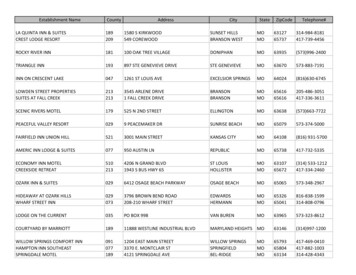
Transcription
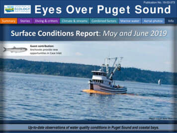
Publication No. 19-03-073Eyes Over Puget SoundSummaryStoriesDiving & crittersClimate & streamsCombined factorsMarine waterAerial photosInfoSurface Conditions Report: May and June 2019Guest contribution:Anchovies provide newopportunities in Case InletPhoto credit Julia BosUp-to-date observations of water quality conditions in Puget Sound and coastal bays.
Summary conditions at a glanceLONG-TERM MARINE MONITORING UNITSummaryStoriesDiving & crittersClimate & streamsCombined factorsMarine waterAerial photosGuest contributionPhillip DionneSteve JeffriesTodd Sandellp.3Anchovies provide new opportunities in Case Inlet.Personal storiesBeach wrack can be a health risk to beachgoers.Julianne RuffnerLaura HermansonTyler BurksJim SheddSkip AlbertsonDr. ChristopherKrembs (Editor)p. 6Climate & streamsp. 9Persistent warm and dry conditions this spring result in lowriver flows. With the snow pack quickly disappearing,Puget Sound will likely be saltier and warmer than normalthis summer. Early upwelling and stagnant water in thesummer may set the stage for a lot of biological activity.Water temperature and food webp. 13In May, average surface water temperatures are warmerthan normal. South Sound and Hood Canal reach optimaltemperatures for geoduck growth.Aerial photographyp. 14By June, the productive season is in full swing. WhileNoctiluca takes advantage of blooms in Central Sound,Case and other finger Inlets in South Sound enjoy hugenumbers of anchovies that attract marine mammals.Editorial assistance provided by: Carol Maloy, Suzan Pool, Ruth Froese.Info
Anchovies provide new opportunities in Case InletSummaryStoriesDiving & crittersClimate & streamsCombined factorsMarine waterAerial photosInfoScientists catch anchovies in shallow and deep water of Case InletTodd Sandell, DFWbeach seiningPhillip Dionne, DFWSteve Jeffries, DFWjuvenile anchovyLarge numbers of juvenile anchovy began to appear in South Sound with warmer water in the fall of 2015 and have beenpresent in annual fall surveys since then. Here is an example of 250K juvenile anchovies caught with only one net set.
Anchovies provide new opportunities in Case InletSummaryStoriesDiving & crittersClimate & streamsCombined factorsMarine waterAerial photosInfoHundreds of California sea lions forage on large schools of anchovy in Case InletIn February, a large group of California sea lions appeared in Case Inlet. Steve Jeffries, a seasoned ResearchScientist with WDFW’s Marine Mammal Investigations, knew why. Since January, he monitored, by boat, thisgroup of 400 to 500 sea lions, harbor seals, harbor porpoise, and long-beaked common dolphins. Heobserved the diverse mammals worked as a team to herd schools of anchovies into deeper areas of CaseInlet. WDFW estimates 800 to 1,000 California sea lion males feed in Puget Sound and Hood Canal eachyear, arriving in late summer and staying until late spring when they return to rookeries in California.
Anchovies provide new opportunities in Case InletSummaryStoriesDiving & crittersClimate & streamsCombined factorsMarine waterAerial photosInfoWhat happened to the California sea lions and anchovies in Case Inlet?The feeding frenzy on anchovies continued until a group of 25 transient killer whales moved intoCase Inlet at the end of March after which only 70–80 sea lions remained south of the Tacoma Narrows.fishfishHerron IslandfishfishfishOrcas reduced the feeding pressureof sea lions on anchoviesHuge schools of anchoviesoccur in North Bay, Case Inletin the spring.Hundreds of sea lions feedon anchovies. Click video(here).Dispersed transient orca pod of 15 individualstravels west past Herron Island.Some anchovies appeared in scat samples of marine mammals. Some were trapped and died on beaches after predatorschased them into shallow water and during outgoing tides. Yet, many remain in South Sound. Like most forage fish speciesin Puget Sound, the abundance of anchovies is not monitored, but this dramatic increase in abundance was hard to miss.
WashingtonBEACHProgram – Eyes on the BeachPersonalFieldImpressionSummaryStoriesDiving & crittersClimate & streamsCombined factorsMarine waterAerial photosInfoBeach wrack can be a health risk to beachgoers.Julianne Ruffner & Laura HermansonLarge piles of organic debris can wash up on beaches. This wrack lingers onbeaches and shallow waters and acts as a reservoir for bacteria. If you come incontact with bacteria in wrack, sand, or water, your risk of getting sickincreases. To prevent you and your family from getting exposed, the BEACHprogram monitors fecal indicator bacteria and advises beachgoers whenbacteria numbers are high. We record the extent of wrack at a beach to betterunderstand its potential risks to human health.Read swimming tips to minimize your risk of illness while visiting our beachesAdvisories areissued if we seehigh bacteria in thewater.Washed up wrackon the beach canharbor bacteria.Signs warn of exposure riskFreeland County Park, Island County
What can you find underwater?SummaryStoriesDiving & crittersClimate & streamsCombined factorsMarine waterAerial photosInfoWhat was the water visibility like for divers?Best visibility in MayBest VisibilityWorst n1(only best visibility shown)Find depths with high/lowvisibilityBest and worst horizontal visibilityat corresponding vertical depth Best visibility occurred in ElliottBay near Seacrest Park (location9) with 49 ft visibility (at 54 ftdepth), despite having poorvisibility near the surface. Poor visibility (no diver icon)occurred in Hood Canal near thesurface (location 11) with muchbetter visibility below. The poster, “Underwater VisibilityMaps – a Tool for Scuba Divers,”is available here.GoodVisibilityPoorThis is a new feature and we are soliciting feedback(skip.albertson@ecy.wa.gov).
What can you find underwater?SummaryStoriesDiving & crittersClimate & streamsCombined factorsMarine waterAerial photosInfoHow can we tell what might be schooling fish vs. seagrass?A.B.schoolingfishGoogle images help us figure it out.Fish move around whereas seagrass don’t.A. Round dark patches in photos taken on 6-4-2019 in Totten Inlet arenot present in Google images (date unknown) and therefore very likelyschooling fish.B.?B. The dark patches are missing in Google images yet other nearshore features are preservedGoogle image
How much water did we get and what can we expect?SummaryStoriesDiving & crittersClimate & streamsCombined factorsMarine waterAerial photosInfoDuring the previous 30 days, Puget Sound air temperatures were above normal, while precipitationwas generally below normal (A). Though some snowpack persists at higher elevations, historicalmonitoring sites show that overall peak mountain snow volumes in 2019 (black line) were belownormal (green line) (B). Persistent warm and dry conditions this spring has also led to the snowpackmelting 1-3 weeks early.A. Northwest Climate ToolboxTemperatureTemperature Anomalyfrom historical mean rangedfrom 1 to 4 F in the PugetSound region during thepast 30 days.B. Washington SNOTEL, USDA/NRCSPrecipitationPrecipitation Anomalyfrom historical meanranged from 0 to -5 inchesin the Puget Sound regionduring the past 30 days.Snow water equivalents for watersheds draining toPuget Sound were below the historical median in2019 (only showing North Puget Sound). SNOTEL(snow telemetry) monitoring sites indicate thatsnowpack is nearly gone.
How much water flows into Puget Sound?SummaryStoriesDiving & crittersClimate & streamsCombined factorsMarine waterAerial photosInfoContinued warm and generally dry conditions has led to rivers receiving early and generally reduced peaks insnowmelt, unless coupled with additional precipitation (trend charts, left). Most stream gages are reportingbelow normal flows and some are the lowest recorded for the date (map, right). These conditions led todrought declarations in some Puget Sound watersheds to occur as early as May 20th, 2019.Select Puget Sound Streamflow TrendsCurrent Streamflow Conditions as of 6/4/2019Daily average discharge, in cubic feet per secondSkagit River near Mt. Vernon(12200500)Snohomish River near Monroe(12150800)Puyallup River at Puyallup(12101500)USGS WaterWatch: CLICK HERE!Current conditions: CLICK HERE!
Climate influences: How well is Puget Sound exchanging its water?SummaryStoriesDiving & crittersClimate & streamsCombined factorsMarine waterAerial photosInfoHistorically, the peaks of coastal upwelling and the freshet are in sync. In 2018, a strong freshet preceded low flows.Fraser RiverThe Fraser River is the major driver ofestuarine circulation and waterexchange between the Salish Sea andthe ocean. Fraser River flows are closeto expected levels. Dramatic snowHigher than normalLower than normalExpectedmelt in May resulted in well belownormal snow pack in BritishColumbia (here).1.5251150.50-0.5-1-1.51945 1950 1955 1960 1965 1970 1975 1980 1985 1990 1995 2000 2005 2010 20155-5-15-25NPGO (x10)PDO/Upwelling IndexThree-year running average of PDO, Upwelling, and NPGO IndicesHow do ocean boundary conditionsaffect the quality of water weexchange with the ocean?Recent years’ warm water is gone(PDO) and upwelling is expected(Upwelling Index anomaly). NPGO,which reflects the surface productivityalong the coast, is expected as well.Pacific Decadal Oscillation Index (PDO, temperature, explanation). Upwelling Index (anomalies) (Upwelling, lowoxygen, explanation). North Pacific Gyre Oscillation Index (NPGO, productivity, explanation).
What influences Puget Sound’s water quality?SummaryStoriesDiving & crittersClimate & streamsCombined factorsMarine waterAerial photosInfoIn the anomaly plot, we want to connect different factors influencing water quality in thecontext of space and time. Conditions leading up to June 2019 were drier with lower riverflows than in Spring 2018. The recent winter has been warmer than the previous two winters,but this February was much colder. Early onset upwelling was a factor in both 2018 and 2019.For recent river and stream inflow, see page 9.Conditions leading up to June:Air temperatures were generallywarmer this year, except in Februaryand early March.Precipitation for the past five monthswas lower than in 2018.Sunshine (opposite of cloud cover) washigher than the previous winter in allareas except near the coast.River flows were low through thewinter.Upwelling was more summer-like inearly spring during 2018 and 2019.ENSO (MEI2) has showed warming.All data are from public sources: UW GRAYSKIES; riverflows from USGS and Environment Canada; indices fromNOAA & UW (PDO).*Upwelling/downwelling Anomalies (PFEL)PDO Pacific Decadal OscillationhigherENSO El Niño Southern OscillationexpectedlowerNo data
Water temperature affects ecosystem performanceSummaryStoriesDiving & crittersLifecyclesTemperatureClimateCan organismsthrive and survive?Climate & streamsCombined factorsMarine waterAerial photosInfoIn May, average surface water temperatures (0 – 30 m deep) were 0.6 Cwarmer than the baseline (1999 – 2016). Optimal temperatures for geoduckgrowth were reached in both South Sound (at expected temperatures) andHood Canal (at 1.2 C above baseline). All basins remained at watertemperatures needed for herring to spawn.Optimal temperatures forPuget Sound organisms*The life cycles of organismsrespond to temperature. Tobe successful, the timing ofearly life stages must line upwith good growth conditions.Temperature is important forgrowth, but also dictates ifcertain organisms canoverwinter in Puget Sound(e.g., Northern anchovy).* Help us get these right. We scoured theliterature for temperatures important tothe success and survival of marineorganisms.Legend:Expected 18-year averageCooler than expectedWarmer than expected
What are the conditions at the surface?SummaryStoriesDiving & crittersClimate & streamsCombined factorsMarine waterAerial photosInfoThe productive season with big algal blooms is in full swing. Noctiluca takes advantage of blooms inCentral Sound and, to a lesser extent, in Hood Canal and Carr Inlet. Case and other finger inlets inSouth Sound enjoy a huge number of anchovies that attract marine mammals. Jellyfish are presentin Budd and Eld Inlets, and macro-algae form along many beaches.Start hereeddyFrontNarrowHammersleyconnectingStateferry crossingInleta tidaleddy in Rich OaklandPassage BayeddyMixing and fronts:Tidal eddies in Rich Passage. Fronts at the fringes of large riverplumes. Mixing of effluent water to the surface in GraysHarbor.PlumeJellyfish and fish:Jellyfish patches present in Budd and Eld Inlets and absent inother places. Numerous schools of fish in south sound inlets.DebrisBloomBloomBloom leaving shallow North Bay at low tideSuspended sediment:Glacial flour entering with the Puyallup River.Visible blooms:Strong brown-green blooms in Central Sound.Red-brown bloom in Sinclair Inlet and North Bay (Case Inlet).Green bloom in Carr Inlet and Quartermaster Harbor.Noctiluca bloom (bright orange) in Central Sound.Debris:Orange-colored organic material of Noctiluca on a large scalein Central Sound and a smaller scale in Carr Inlet and southernHood Canal.
SummaryStoriesDiving & crittersClimate & streamsCombined factorsMarine waterAerial photosComposite map from two flight datesAerial navigation guideSan Juan IslandsPadilla BayStrait ofJuan de FucaWhidbey Basin1Aberdeen,Grays HarborFlight1516Hood Canal1819810642143220Flight ObservationsMain Basin9173South Sound1312Tide data from 6/4/2019 (Seattle):TimePredHigh/Low12:15 AM6.99L5:09 AM10.78H12:17 PM-2.83L7:43 PM11.77H711Sunny and hazyPeople sharing images5Info
1SummaryAerial photography 6-4-2019StoriesDiving & crittersA. 6-4-2019Climate & streamsMarine waterAerial photosInfoB. 3-26-2019bridgeWSDOT reportedMesodinium rubrumbloom, in the Chehalis riverBloomCombined factorsNavigateeffluentCow PointeffluentC. 9-25-2018Cow PointeffluentA. Effluent from Cosmo Specialty Fiber rises to the surface. June 2019. B. March 2019. C. September 2018.Location: Aberdeen (Grays Harbor)
2Aerial photography 5-13-2019SummaryStoriesDiving & crittersA. 2:49 PMfishfishClimate & streamsBoston HarborCombined factorsMarine waterAerial photosB. 1:47 PMGravelly fishfishC. 2:36 PMNorth BayD. 1:53 PMboatfishpensSquaxin Islandfishfishfishfishfishfish?Schools of fish in shallow regions of South Sound. How do we know it’sits fish?Location: A. Budd Inlet, B. Totten Inlet, C. Case Inlet (North Bay), D. Peale Passage (South Sound)Info
3Aerial photography 6-4-2019SummaryStoriesDiving & crittersClimate & streamsA. 11:34 AMCombined factorsNavigateMarine waterB. 1:34 PMfishjellyfishfishjellyfishAerial photosfishjellyfishfishfishfishjellyfish1:54 PMfishD. 1:58 PMBloomC.Gallagher ools of fish in shallow regions of South Sound. HowLocation: A. Budd Inlet, B. Case Inlet, C. Totten Inlet, D. Eld Inlet (South Sound)Info
4Aerial photography 5-13-2019SummaryStoriesDiving & crittersClimate & streamsCombined factorsNavigateMarine waterAerial photosDebrisMaury IslandDebrisVashon IslandboatOrganic debris floating at surface.Location: Quartermaster Harbor (Central Sound), 2:08 AMInfo
5Aerial photography 5-13-2019SummaryStoriesDiving & crittersClimate & streamsA.Combined factorsNavigateMarine waterAerial We share people’s experiences with Noctiluca on the water. Thank you for the great contributions.Location: A. Des Moines Marina, B. Holmes Harbor, C. Edmonds, D. Port Blakely, E. Central SoundInfo
6SummaryAerial photography 5-13-2019StoriesDiving & crittersClimate & streamsCombined factorsNavigateMarine waterferryNoctilucaLarge Noctiluca bloom stretching from Poverty Bay to West Point.Location: Arroyo Heights, Fauntleroy (Central Sound), 2:14 PMAerial photosInfo
7Aerial photography 5-13-2019SummaryStoriesDiving & crittersClimate & streamsCombined factorsNavigateMarine watercabin reflectionsNoctilucaLarge Noctiluca bloom stretching from Poverty Bay to West Point.Location: Shorewood (Central Sound), 2:15 PMAerial photosInfo
8SummaryAerial photography 5-13-2019StoriesDiving & crittersClimate & streamsCombined factorsboatNavigateMarine waterboatNoctilucaLarge Noctiluca bloom stretching from Poverty Bay to West Point.Location: Alki Point, West Seattle (Central Sound), 2:25 PMAerial photosInfo
9SummaryAerial photography 6-4-2019StoriesDiving & crittersClimate & streamsMarine waterAerial photosInfoDebrisboatCombined factorsNavigateBloomNoctilucamacro-algaeRed-brown and turquoise bloom and organic material at the surface. Macro-algae developing on beaches.Location: Pitt Passage, McNeil Island (Carr Inlet), 11:43 PM
SummaryAerial photography 6-4-2019StoriesDiving & crittersClimate & streamsNavigateCombined factorsMarine waterFox IslandWater with red-brown bloom flowing around Fox Island Sand Spit.Location: Fox Island (Carr Island), 11:45 AMAerial photosBloom10Info
11Aerial photography 6-4-2019SummaryStoriesDiving & crittersClimate & streamsCombined factorsNavigateMarine waterAerial photosVashon IslandferryDebrisNoctilucaPlumeBloomboatNoctiluca, dark brown bloom, and glacial flour in the Puyallup River plume reaching westward.Location: Commencement Bay (Central Sound), 11:51 PMInfo
12StoriesDiving & crittersClimate & streamsCombined factorsNavigateMarine waterAerial photosPlumeBloomSummaryAerial photography 6-4-2019Greenish bloom and glacial flour in the Puyallup River plume extending northward.Location: Commencement Bay (Central Sound), 11:51 PMInfo
13Aerial photography 6-4-2019SummaryStoriesDiving & crittersClimate & streamsCombined factorsNavigateMarine waterAerial photosInfoTacomaboatBloomPlumeDash PointGreenish bloom and glacial flour in the Puyallup River plume might be Noctiluca prior to surfacing.Location: Commencement Bay (Central Sound), 11:52 AM
14SummaryAerial photography 6-4-2019StoriesDiving & crittersClimate & streamsCombined factorsNavigateMarine waterMaury IslandPiner PointPlumeNoctilucaNoctiluca and glacial flour in the Puyallup River plume.Location: Maury Island (Central Sound), 11:52 AMAerial photosInfo
15Aerial photography 6-4-2019SummaryStoriesDiving & crittersCombined factorsMarine waterAerial photosB.BloomA.Climate & streamsNavigateBlake IslandbargeBloomWest SeattleDebrisDebrisSeattleBloomC.Dark brown bloom (diatoms) organic material stretching from Edmonds to Commencement Bay.Location: A. Southworth, B. Blake Island, C. Across Elliott Bay (Central Sound), 12:00 PMInfo
16Aerial photography 6-4-2019SummaryStoriesDiving & crittersClimate & streamsboatMarine waterAerial photosBremertonBloomBloommacro-algaeCombined factorsNavigateAnnapolisboatmacro-algaeWater in dark and light green meeting along front. Macro-algae on beaches.Location: Annapolis, Sinclair Inlet (Central Sound), 12:26 PMInfo
17Diving & crittersClimate & streamsNavigateCombined factorsMarine waterAerial photosLittle Skookum InletOyster BayBloomDebrisStoriesBloomSummaryAerial photography 6-4-2019Water with red-brown and turquoise bloom meeting along front.Location: Totten Inlet (South Sound), 1:54 PMInfo
18StoriesDiving & crittersClimate & streamsCombined factorsNavigateMarine waterAerial photosArcadiaboatpensBloomSummaryAerial photography 6-4-2019fishRed-brown bloom and schools of fish.Location: Totten Inlet (South Sound), 1:54 PMfishInfo
19SummaryAerial photography 6-4-2019StoriesDiving & crittersClimate & streamsCombined factorsNavigateMarine waterSteamboat IslandCooper PointboatjellyfishJellyfish aggregations.Location: Eld Inlet (South Sound), 1:57 PMjellyfishAerial photosInfo
20StoriesDiving & crittersClimate & streamsCombined factorsNavigateMarine waterAerial photosGravelly BeachBloomfishjellyfishboatSunset BeachPatches of a red-brown bloom, schools of fish, and jellyfish.Location: Eld Inlet (South Sound), 1:57 PMBloomSummaryAerial photography 6-4-2019jellyfishInfo
Find past editions of EOPS on the next pagesSummaryStoriesDiving & crittersClimate & streamsCombined factorsMarine waterAerial photosInfoWe have published 81 editions!Find all previous Eyes Over Puget Sound editions at the end of this document.Recommended Citation (example for September 2018 edition):Washington State Department of Ecology. 2018. Eyes Over Puget Sound: Surface ConditionsReport, September 17, 2018. Publication No. 18-03-075. Olympia, nts/1803075.pdf.Many thanks to our business partners:Shannon Point Marine Lab (WWU), SwantownMarina, and Kenmore Air.Contact:Dr. Christopher KrembsChristopher.Krembs@ecy.wa.govMarine Monitoring UnitEnvironmental Assessment ProgramWashington StateDepartment of EcologySubscribe to the Eyes OverPuget Sound email listserv.
Month date year,Publication No. 20-03-07XMonth date year,Publication No. 20-03-07XMonth date year,Publication No. 20-03-07XMonth date year,Publication No. 20-03-07XMarch 16 2020,Publication No. 20-03-071Jan 10 2020,Publication No. 20-03-070October 30 2019,Publication No. 19-03-076September 12 2019,Publication No. 19-03-075July 29 2019Publication No. 19-03-074June 4 2019,Publication No. 19-03-073March 26 2019,Publication No. 19-03-072February 21 2019,Publication No. 19-03-071January 10 2019,Publication No. 19-03-070November 6 2018,Publication No. 18-03-075September 17 2018,Publication No. 18-03-074July 16 2018,Publication No. 18-03-073June 28 2018,Publication No. 18-03-072May 22 2018,Publication No. 18-03-025April 19 2018,Publication No. 18-03-071Winter 2018,Publication No. 18-03-070
October 31 2017,Publication No. 17-03-073August 28 2017,Publication No. 17-03-072July 24 2017,Publication No. 17-03-071June 6 2017,Publication No. 17-03-070December 31 2016,Publication No. 16-03-079November 22 2016,Publication No. 16-03-078September 26 2016,Publication No. 16-03-077August 24 2016,Publication No. 16-03-076July 20 2016,Publication No. 16-03-075June 27 2016,Publication No. 16-03-074May 2 2016,Publication No. 16-03-073April 6 2016,Publication No. 16-03-072March 16 2016,Publication No. 16-03-071February 8 2016,Publication No. 16-03-070December 30 2015,Publication No. 15-03-080December 14 2015,Publication No. 15-03-079October 6 2015,Publication No. 15-03-078September 21 2015,Publication No. 15-03-077August 8 2015,Publication No. 15-03-076July 6 2015,Publication No. 15-03-075
June 8 2015,Publication No. 15-03-074April 29 2015,Publication No. 15-03-073March 24 2015,Publication No. 15-03-072February 17 2015,Publication No. 15-03-071January 28 2015,Publication No. 15-03-070December 30 2014,Publication No. 14-03-080November 17 2014,Publication No. 14-03-079October 29 2014,Publication No. 14-03-078September 16 2014,Publication No. 14-03-077August 18 2014,Publication No. 14-03-076July 28 2014,Publication No. 14-03-075June 23 2014,Publication No. 14-03-074May 12 2014,Publication No. 14-03-073April 21 2014,Publication No. 14-03-072March 24 2014,Publication No. 14-03-071February 4 2014,Publication No. 14-03-070December 31 2013,Publication No. 13-03-081November 21 2013,Publication No. 13-03-080October 28 2013,Publication No. 13-03-079September 11 2013,Publication No. 13-03-078
August 21 2013,Publication No. 13-03-077July 15 2013,Publication No. 13-03-076June 17 2013,Publication No. 13-03-075May 20 2013,Publication No. 13-03-074April 8 2013,Publication No. 13-03-073Mar 25 2013,Publication No. 13-03-072February 26 2013,Publication No. 13-03-071January 15 2013,Publication No. 13-03-070December 13 2012,Publication No. 12-03-081November 8 2012,Publication No. 12-03-080October 8 2012,Publication No. 12-03-079September 11 2012,Publication No. 12-03-078August 27 2012,Publication No. 12-03-077July 31 2012,Publication No. 12-03-076June 12 2012,Publication No. 12-03-075May 14 2012,Publication No. 12-03-074April 23 2012,Publication No. 12-03-073March 19 2012,Publication No. 12-03-072February 27 2012,Publication No. 12-03-071January 30 2012,Publication No. 12-03-070
December 5 2011,Publication No. 11-03-082November 15 2011,Publication No. 11-03-081October 17 2011,Publication No. 11-03-080September 12 2011,Publication No. 11-03-079August 8 2011,Publication No. 11-03-078July 6 2011,Publication No. 11-03-077June 20 2011,Publication No. 11-03-076June 6 2011,Publication No. 11-03-075May 4 2011,Publication No. 11-03-074April 27 2011,Publication No. 11-03-073
Washington BEACH Program - Eyes on the Beach. Advisories are issued if we see high bacteria in the water. Washed up wrack on the beach can harbor bacteria. Freeland County Park, Island County. Large piles of organic debris can wash up on beaches. This wrack lingers on beaches and shallow waters and acts as a reservoir for bacteria. If you come in