Transcription
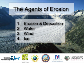
The Agents of Erosion1.2.3.4.Erosion & DepositionWaterWindIce1CaliforniaScience Project
1. Erosion and DepositionUSGSErosion is the physical removal andtransport of material by mobileagents such as water, wind or ice.The three common agents of erosionare: water wind Ice2USGSNWSThese agents are mobile at theEarth’s surface and are responsiblefor the transport of sediment.
Erosion and mass wasting appearto be similar processes but havedistinctly different causes.USGSThe movement of sediment byerosion requires mobile agentssuch a water, wind and ice. That is,the sediment is transported by themovement of the agents.3USGSMass wasting (commonly referred to aslandslides) involves the transfer of rockand soil downslope under the influence ofgravity. Gravity is the key factor in masswasting and the movement of materialdoes not require a mobile agent.
Weathering results in two types of products:1. solid particles (sand grains, clay minerals, etc.)2. dissolved constituents in waterThese different types of sediment result in two fundamentallydifferent types of sedimentary rocks:1. detrital (clastic) sedimentary rocks - formed from transportedsolid particles (detritus or clasts).2. chemical sedimentary rocks - formed by the precipitation ofdissolved substances by either inorganic or biologic processesriver rockssalt flat
Particle Size Classification of Detrital Sedimentary RocksSize Range (mm)Particle Name 256Boulder64 - 256Cobble4 - 64Pebble2-4Granule1/16 - 2Sand1/256 - 1/16Silt 1/256ClaySediment NameRock NameGravelConglomerateor BrecciaSandSandstoneMudShale orMudstone
Erosion (transport of sediment) usually ends with the depositionof sediments (and soil). Deposition occurs when the forcesresponsible for erosion are no longer sufficient to transport thesediment.There are awide variety ofenvironmentson the Earth’ssurface wherethe depositionof sedimentsoccur as theresult of fluvial(rivers), aeolian(wind) andglacial (ice)erosion.6Wikimedia: Minkenorton
The particle shape may indicateinformation about origin andtransport (rounded v. angular).Sizes of particles can provideuseful information about theenvironment of deposition: Gravels are found in highenergy environments such asmountain streams and somebeaches. Sands are found inintermediate energyenvironments such as beachesand river deposits. Clays are found in quietenvironments such as lakes andthe deep ocean.
2. Erosion by WaterWater is the most efficient andeffective agent for erosion.Erosion by water commonly occurs intwo different geologic settings:1. Coastlines – erosion that occurson coastlines is due to the actionof ocean currents, waves, andtides.2. Streams and Rivers – erosioncommonly occurs along the bankof the stream. A stream is any sizechannelized body of runningwater (small creeks to giantrivers).USGS
Streams are able to transport sediment very long distances. Thereare different types of material carried by a stream depending onthe size and chemical properties.1) Dissolved load - transport of ions and chemicals in solution responsible for the saltiness of the sea.2) Suspended Load - typically the largest load - clays, silt and finesand. This material settles out when the river slows (settlingvelocity) usually in an ocean or lake.3) Bed Load - the material thatis transported along theriver bed - rolling, slidingand saltation - where theparticles bounce or skipalong the river bed.
The sediment found in a river bed isevidence of the type of sediment that isbeing transported.The sediments found in a river bed areindicative of the energy of the river.The stream gradient is the grade or thedrop in elevation of a stream (as aratio) and is usually expressed asfeet/mile or m/km. The higher thegradient, the greater the energy in thestream.Very high energy mountain streams cantransport large particles, boulders andgravel whereas lower energy streamscan only transport more fine sedimentsuch as silt and clay.10
Streams will erode the surface by cuttingdownward and tend to form V-shapevalleys. Rivers with steep gradients tendto form steep walls. Rivers with shallowergradients tend to form broader valleys.Geographer OnlineNPSUSGSWhen a stream has a very shallowgradient (nearly flat), most of theerosion is lateral (side to side) andsediment is deposited forming floodplains. The stream valley can bevery broad and gentle.
USGSNOAAStreams form a widevariety of landforms due toerosion and the depositionof sediments.Alluvial fans and deltas arelandforms that result fromthe deposition ofsediments. They aresimilar structures, and differmainly by being depositedeither above or belowwater. They are formedfrom the deposition of thesediment carried by theriver it flows into a canyonor flatter plain (fan) or anocean or a lake (delta).
3. Erosion by WindCompared to running water andglaciers, wind erosion is relativelyinsignificant as an agent of erosion.It is more effective in dry landscompared to humid environments.The photo to the right (NASA)shows a small dust storm blowingNASAfrom Sudan onto the Red Sea.In the 1930's, large dust stormsoccurred in the midwest of theU.S. - "Dust Bowl." This occurredbecause of poor soil practices(elimination of vegetation) and asevere drought.13NOAA
The transport of sediment by wind differs from running water intwo important ways:1. Wind's lower densitycompared to watermakes it less capable ofpicking up and depositingcoarse material2. Wind is not confined tochannels - it can spreadover large areas.The suspended load ofwind consists of silt andclay particles - small andplaty grains may takedays to settle down.NASA satellite image of dust storm blowingoff the Sahara Desert across theMediterranean Sea toward Italy.
Stephen A. Nelson (Tulane)Desert pavement develops as a result of deflation leaving thesurface covered with pebbles and cobbles. Other processesmay also lead to the development of desert pavement.Mark A. WilsonIn arid regions, wind erodes thesurface through a process calleddeflation. Deflation lowers the surfaceby removing the finer grain material(sand, silt, clay) and leaving thecoarser material.
NSFThe wind sculpted rock to the leftin the Dry Valleys, Antarctica.Thomas WilkenWind erodes by abrasion whichcan cause interesting shapes.The figure to the right shows theerosion (abrasion) of the lowersofter limestone forming theseshapes in the Libyan desert.Abrasion can be thought of as atype of mechanical weathering.Wind carrying sand particles can abrade surfaces, creatingstrange shapes and giving them a smooth polished appearance.
Sand DunesWind commonlydeposits sand inmounds or ridgescalled dunes.NPSDunes commonly form arounda clump of vegetation or arock - where the wind velocityis decreased (wind shadow).The wind drops its sedimentload making the obstacle evenlarger - self-propagatingprocess.
Many dunes have anasymmetrical profile: steep leeward (downwind)slope gentle windward slopeJohn W. JohnstonSands move up the gentle slope by the force of the wind. At thecrest, the wind velocity decreases and sand grains fall out andaccumulate on the leeward side.The leeward slope is about 34 - the angle of repose for drysand.This process of dune development results in the dunes migratingin the direction of the wind.
As the sand is deposited onthe leeward side, the sand isinclined in the direction that thewind is blowing. These slopinglayers are called cross beds.John W. JohnstonThe photo depicts asandstone in ZionNational Park thatshows preservedsand dunes. Note thewell-preserved crossbeds.NPS
4. Erosion by IceGlaciers cover nearly 10 % of the Earth (decreasing steadily), butin the past, about 30% was covered.They are responsible for the basic character of: European and Southern Alps (NZ). Cape Cod & Long Island. Yosemite Valley, Glacier National Park, Grand Tetons Hudson Bay, Great Lakes, Fiords of Norway & Alaska20Frank Paul, University of ZurichNASA
A glacier is a thick ice mass that originates on land by theaccumulation, compaction and recrystallization of snow. Glaciers are capable of flow, and therefore move downhillunder the force of gravity. When ice accumulates to greater than 50 m thick, the icebelow 50m can flow. The ice above 50 m remains brittle,below it is ductile.50mBrittle (fractures)BedrockDuctile (flows)
Glacial ErosionAs sediment-laden ice moves over rocks, it abrades (polishes)them and may leave grooves or glacial striations on the rocksurface.Tom Lowell NSIDCUSGSGlacial abrasion can bethought of as a type ofmechanical weathering.
Glacial LandformsIce as an agentof erosion canmove largequantities of rockand sculpt thesurface withlandforms thatare distinctive toglacial erosion.Wikipedia: Surachit
NPSNPSGlaciated ValleysPrior to glaciation,mountain valleys aretypically V-shaped fromstream erosion.During glaciation they aredeepened and widen creating a U-shapedvalley.After a glacier melts orretreats, it may be furthermodified by a stream andform a V-shaped valley
Glacial DepositsThe general term for all types of glacial materials is glacial drift.Drift can be broken into 2 groups:1) Glacial Till - material that is deposited directly by a glacier andis not sorted by size , and;2) Stratified Drift or Outwash - deposited by meltwater from theglacier and the sediment is sorted according to size.Glacial drift isdeposited in a widevariety of landforms Hans Hillewaert / CC-BY-SA-3.025
26Wikipedia: AudriusaUSGSBBCMoraines are a deposit ofsediment that forms from thedirect action of a glacier.The figure on the right showsthe different types ofmoraines that can be formed.The image below showslateral moraines exposedafter the retreat of the glacier.
The sediment found in a river bed is evidence of the type of sediment that is being transported. The sediments found in a river bed are indicative of the energy of the river. The stream gradient is the grade or the drop in elevation of a stream (as a ratio) and is usually expressed as feet/mile or m/km. The higher the