Transcription
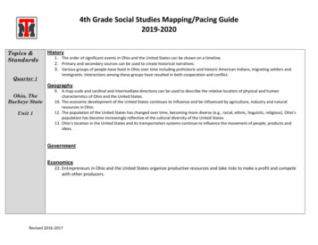
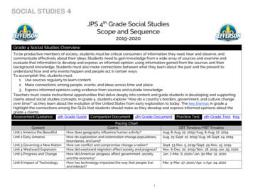
SOCIAL STUDIES 4JPS 4th Grade Social StudiesScope and Sequence2019-2020Grade 4 Social Studies OverviewTo be productive members of society, students must be critical consumers of information they read, hear and observe, andcommunicate effectively about their ideas. Students need to gain knowledge from a wide array of sources and examine andevaluate that information to develop and express an informed opinion, using information gained from the sources and theirbackground knowledge. Students must also make connections between what they learn about the past and the present tounderstand how and why events happen and people act in certain ways.To accomplish this, students must:1. Use sources regularly to learn content.2. Make connections among people, events, and ideas across time and place.3. Express informed opinions using evidence from sources and outside knowledge.Teachers must create instructional opportunities that delve deeply into content and guide students in developing and supportingclaims about social studies concepts. In grade 4, students explore “How do a country’s borders, government, and culture changeover time?” as they learn about the evolution of the United States from early exploration to today. The key themes in grade 4highlight the connections among the GLEs that students should make as they develop and express informed opinions about thegrade 4 claims.Assessment Guidance 4th Grade Guide Companion Document 4th Grade Document Practice Test 4th Grade Test, KeyPacing ChartContentUnit 1 America the BeautifulUnit 2 Early AmericaUnit 3 Governing a New NationUnit 4 Westward ExpansionUnit 5 Progress and ChangeUnit 6 Impact of TechnologyClaimsHow does geography influence human activity?How do exploration and colonization change populations,boundaries, and land?How can conflict and compromise change a nation?How did westward migration affect society and progress?How did American progress affect government, society,and the economy?How has technology impacted the way that people liveand interact?1CBT Timeline/PBT TimelineAug. 8-Aug. 22, 2019/Aug. 8-Aug. 27, 2019Aug, 23-Sept. 12, 2019/Aug. 28-Sept. 24, 2019Sept. 13-Nov. 5, 2019/Sept. 25-Nov. 15, 2019Nov. 6-Dec. 20, 2019/Nov. 18, 2019-Jan. 29, 2020Jan. 7-Mar. 6, 2020/Jan. 30-Mar. 31, 2020Mar. 9-Mar. 27, 2020/Apr. 1-Apr. 24, 2020
SOCIAL STUDIES 4Unit 1: America the Beautiful(11 Days – CBT/14 Days – PBT)OverviewDescription: Students explore a series of maps of the United States spanning history and learn about the geography, culture,and economic activities of regions within the United States.ClaimStudents develop a claim to respond to this overarching question: How does geography influence human activity?Key Connections Climate and Geography shape the economies of the five regions of the United States.The environment of the U.S. has been affected by human factors and natural processes.Unit Terminology and ToolsContent Vocabularycolonial; Pre-Columbian; territory; political; precipitation; compass rose;cardinal directions; intermediate directions; hemisphere; latitude; longitude;physical characteristics; region; natural resources; erosion; impact;migration; topographic; population continents (Africa, Antarctica, Asia,Australia, Europe, North America, South America), oceans (Pacific, Atlantic,Southern Indian, Arctic), Equator, regions (West, Southwest, Midwest,Southeast, Northeast), physical features (mountains, canyons, forests,desert, plains), waterways (rivers, bayous, coasts, lakes), natural resources2
SOCIAL STUDIES 4(gold, minerals, coal, oil, seafood, timber, grazing land, fur, soil/farmland),ports, natural disasters (tornadoes, hurricanes, floods, forest fires,earthquakes, volcanoes, mudslides, thunderstorms), land alterations (roads,dams, levees, canals, irrigation, waste, mining), geography, climate,economy, map types (physical, political, topographic, road, climate,resource, population), map title, map key/legend, compass rose, distancescale, coordinates, gridsDBQ Project CorrelationCLEVER: n/aStudies Weekly CorrelationCLEVER: USA Studies Weekly: Ancient America to the Present, Weeks 11-12Supplemental MaterialDiscovery Education: States, American Geography, Location, Size, andRegions of the U.S.WorldBook Online: What is a Map? How to Measure DistanceAssessments LDOE Unit 1 Assessment: Students will write an essay answering the question: How do geography and physical featuresimpact economic activities and cultures? JPS Unit 1 AssessmentEssential GLEsEssential content represents the most important concepts to be taught in eachunit. Teachers should spend the majority of their time teaching the essentialcontent.3
SOCIAL STUDIES 44.5.1 Compare and contrast thedistinguishing physical characteristicsof the five regions of the UnitedStates.Priority Concepts and ContentCompare and contrast the physical characteristics within each region, andbetween regions: West: mountains, coastline, farmland, forest Southwest: deserts, canyons, farmland Midwest: plains, rivers, farmland Southeast: bayous, rivers, coastline, mountain ranges, farmland Northeast: coastlines, waterways, natural deep harbor ports4.5.2 Analyze how physicalcharacteristics of a region shape itseconomic development.Priority Concepts and ContentDescribe the main natural resources in each region, and their impact on thepopulation and economy of that region: West: gold/materials, seafood, timber, seaports on the coast, mining Southwest: metals/minerals, grazing land, farm resources, oil, adobebuilding materials, inland ports Midwest: coal mining, agriculture, fertile soil, fur Southeast: seafood, oil, agriculture, seaports, rivers, coal, fertile soil Northeast: forests, seafood, natural deep harbor seaports, rivers, furs4.6.1 Illustrate how natural processeshave created and/or changed thephysical characteristics of places inthe United States.Priority Concepts and Content Explain what causes erosion, and how erosion has changed the physicalcharacteristics of coastal areas in the U.S. Identify natural disasters common to each U.S. region (tornadoes,hurricanes, floods, forest fires, earthquakes, volcanoes, mudslides, severethunderstorms) and explain why that natural disaster is likely to occur in thatregion. Explain how natural disasters have changed the physical characteristics ofthe five regions in the U.S. Explain how rivers have impacted farmland by contributing fertile soil.4
SOCIAL STUDIES 44.6.2 Describe the human impact onthe land and bodies of water of thefive regions of the United States.Ancillary GLEsPriority Concepts and Content Explain ways in which humans have altered the land in each of the fiveregions of the U.S. (roads, dams, levees, canals, irrigation systems, waste,pollution, mining, cattle grazing).Ancillary content represents skills that are used in support of bigger ideas,review content within a unit, and historical thinking skills. Ancillary contentshould not be cut from instruction.4.1.4 Produce clear and coherentwriting to: compare and contrast pastand present viewpoints on a givenhistorical topic; conduct simpleresearch; summarize actions/eventsand explain significance; differentiatebetween the five regions of the UnitedStatesPriority Concepts and ContentOptions to cover 4.1.4 in this unit: Conduct simple research on the geography of the five regions of theUnited States. Compare and contrast the geography, climate, and economies of thefive regions of the United States. Differentiate between geography, climate, and economies of the fiveregions of the United States.4.4.1 Locate and label continents,oceans, the poles, hemispheres, andkey parallels and meridians on a mapand globe.Priority Concepts and Content Label the 7 continents (Africa, Antarctica, Asia, Australia, Europe, NorthAmerica, South America), 5 oceans (Pacific, Atlantic, southern, Arctic, Indian),North Pole, South Pole, and Equator on a blank map.4.4.2 Locate and label on a map themajor physical features of each of thefive regions of the United States andsummarize how they affect theclimate, economy, and population ofeach region.Priority Concepts and Content Name the five regions of the U.S. (West, Midwest, Southwest, Southeast,Northeast), and locate and label them on a map. Locate and label on a map the major physical features of each U.S.Region, and how these physical features affect the region’s population andeconomy. West: Pacific Ocean, Rocky Mountains, Cascade Mountains Southwest: Grand Canyon, border with Mexico5
SOCIAL STUDIES 4 Midwest: Ohio River, Mississippi River, Great Lakes, Great Plains Southeast: Appalachian Mountains, Mississippi river, GulfCoast/Atlantic Coast Northeast: Atlantic Coast and waterways, Niagara Falls Describe the climate of each of the regions of the U.S., and explain howthe climate impacts the economy and population of each region.4.4.3 Identify the states of each of thefive regions of the United States.Priority Concepts and Content Name the states that are in each region, using a map.4.4.4 Measure approximate distance ona map using scale to the nearesthundredth mile.Priority Concepts and Content Measure the distance between different places on a map using a scale.4.4.5 Determine the approximatelongitude and latitude coordinates ofvarious locations in the United States.Priority Concepts and Content Using a map, determine the approximate longitude and latitudecoordinates of teacher selected locations in all five regions of the UnitedStates.4.4.6 Interpret various types of mapsusing a key/legend, compass roseincluding cardinal and intermediatedirections, latitude/longitude, andscale.Priority Concepts and Content Explain what information maps give us using physical, political,topographic, road, climate, resource, and population maps, and giveexamples of when each type of map is best used. Proficiently use each feature of a map: title, key/legend, compass rose,cardinal and intermediate directions, and scale. Explain the purpose of latitude and longitude lines. Identify places on the map using latitude and longitude coordinates.4.4.7 Use mental mapping to constructa map of the United States regions andthe world to include map elements(title, compass rose, legend/key, scale).Priority Concepts and Content Create a key/legend and label/color each region of the U.S. on a map.6
SOCIAL STUDIES 44.5.3 Identify and explain how thephysical characteristics of a regioninfluenced human settlement.Priority Concepts and Content Explain how physical features limited human migration and settlement(mountains, deserts, and crossing large waterways created barriers to traveland migration before railway technology). Explain how rivers and waterways promoted settlement and migration.Topic 1: The Many Maps of the United StatesBefore students can analyze the connection between geography and human activity, they need to understand how mapsare used to learn about a specific area. In Unit One, students gain a basic understanding of world and US geography, andpractice reading & interpreting a variety of world and US maps. Students learn to use different types of maps so that theyare later equipped to make connections between them.GLEsEssential:N/AAncillary:4.1.4; 4.4.1; 4.4.4; 4.4.5; 4.4.6Key Questions What information do maps tell us about a given area? How do we read a map? Why do we use maps?Timeline: 5 Days (CBT)/7 Days (PBT)The activities below were created by the LDOE as sample lessons for this topic.Additional information for each topic can be found in the Priority Concepts andContent section of the Essential and Ancillary GLEs.7
SOCIAL STUDIES 4Exploring Maps1. Say: “This year we are going to learn how a country’s borders and people change over time. One tool we will use is amap.”2. Explain to students that a map is a drawing that shows what places look like from above and where they are located.Say: “I would like you to think about why maps are necessary. Work with a shoulder partner to discuss why people usemaps and write your answer in the space provided in the Students Resource Book.” Encourage students to use theconversation stems at the beginning of the Student Resource Book during their discussions and provide evidence fromtheir background knowledge to support their answers. Upon completion, ask several students to share their responseswith the class. Additional guiding questions include:a. What did people do before GPS and cell phones?b. What information do maps give us?3. Display a series of world and U.S. maps. (See links below.) Using the sources in the Student Resource Book, havestudents work with a shoulder partner to analyze the maps, noting similarities and differences in the spaces provided.a. Pre-Columbian world mapb. Columbus, Magellan, and De Gama 1482-1522c. Modern World Mapd. Early Colonial Map of Americae. U.S. Territory 1810f. Modern U.S. Map4. Select several pairs to share their responses with the class.Using Map Tools5. Say, “This year, we will continue to practice our map skills as we explore the changing United States. We will learn whythese maps and boundaries of countries keep changing even when the land stays the same.”6. Project a modern world map. Say: “A map has useful features, such as a title, legend, compass rose, and scale.” Reviewthe following features with students and have them brainstorm the function of each feature. Ask: “When might we need touse this feature?”8
SOCIAL STUDIES 4a. Title: the name or type of map, including any dates or noted time periodb. Map legend: a list of shapes and symbols used on a map with an explanation of eachc. Compass rose: a symbol that shows direction (north, east, south, west, southeast, northeast, southwest, andnorthwest) on a map.d. Scale: gives the ratio between distance on a map and the corresponding distance on the ground7. Continue to project a modern world map. Have students turn to the Outline Map of the World in their Student ResourceBooks. Have each student point to the seven continents and five oceans on the map as they are projected to the class.Then, instruct students to refer to the directions on the previous page to complete the Outline Map of the World. Say:“Using the map on the next page, complete the following tasks: Color the seven continents green Color the five oceans blue Label the North Pole and the South Pole Trace the equator in red Write a title Draw a compass rose Create a legend8. On a projected world map, point out important information (Ex. Where North America is located in relation to othercontinents, that South America is located below North America, that Europe is located across the Atlantic Ocean from theUnited States, that Australia is an island, that Antarctica is the most southern continent, etc.)9. Show students a globe, if available, and point out the differences between the globe and a two-dimensional map.Remind them that the Earth is round.10. Have students work with a shoulder partner to verbally practice using cardinal and intermediate directions to describewhere different places are in relation to Louisiana. (Ex. Canada is north of Louisiana. Australia is southeast of Louisiana.) Askstudent pairs to correctly label the compass rose in their Student Resource Books, and then, create a question and answerusing a cardinal or intermediate direction. Instruct student pairs to pose their questions to another pair and answer eachother’s questions using a map in the Student Resource Book – one student in the pair can state the answer while the other9
SOCIAL STUDIES 4demonstrates on a map. This can be accomplished by students rotating around the room to other paired students or byrotating to the front of the classroom so all students can witness the questions and map demonstrations.11. Say: “Maps don’t just tell us where places are in relation to one another. They also tell us how far apart they are. Using amap and a scale, we can measure the distance between any two places in the world without even leaving our classroom.”Using the “Map of the United States” in the Student Resource Book, have students complete the accompanying “MapScale” activity.12. Have students use the “Location Map” in the Student Resource Book to create a map scale using centimeters and/orinches. Students should then label their city and measure the distances between their hometown and various cities aroundthe world as identified in the Student Resource Book. (Students can use the global map scale or adapt this resource fromNational Geographic to aid in this activity.)13. Have the students turn to the “Map of the United States With Water Boundaries” in the Student Resource Book toidentify the major bodies of water that serve as boundaries on the map. Then, instruct students to draw a compass rosewith cardinal and intermediate directions on the map.Latitude and Longitude14. Say: “So far we know that maps tell us where places are in relation to one another and how far apart they are, but whatif we need to find the exact location of a place? Lines of latitude and longitude help us to plot exact locations on a map.”15. Instruct students to turn to the “Latitude and Longitude Map” in the Student Resource Book. Ask students: “What do youthink is the purpose of the lines you see on the map?”16. Using a wall map or projected map, model how lines of latitude and longitude should be read. Instruct students toselect one line of latitude to trace with a green crayon. Then, instruct them to select one line of longitude to trace with ared crayon. Next, provide students with several coordinates and have them identify specific places on their maps, locatingthe closest continent to the given coordinates.10
SOCIAL STUDIES 417. Have students turn to The World: Latitude and Longitude in the Student Resource Book. Allow students to practicelocating various places by working through the questions on the page. Upon completion, have students share theirresponses with a shoulder partner or in a small group.Comparing Maps18. Say: “Now we have the tools to find specific places on a map, estimate how far apart places are, and navigate a mapusing directions and lines of latitude and longitude. Maps can do more than just tell us where places are. Different types ofmaps can give us all different kinds of information.”19. Have students turn to the “Types of Maps” section (See links below.) in the Student Resource Book or distribute an atlaswith several different types of maps of the U.S. Have students work with a shoulder partner or in small groups to identifyeach type of map and its purpose by interpreting the map tools.a. Types of Maps: Physical Map of the United Statesb. Types of Maps: General Map with Highwaysc. Types of Maps: Political Map with Statesd. Types of Maps: Satellite Viewe. Types of Maps: Population Densityf. Types of Maps: Rivers and Lakes20. Using the maps from the “Types of Maps” section of the Student Resource Book, have students work with a shoulderpartner or in small groups to fill in the “Intro to Maps Graphic Organizer.” Identify the column referencing “natural or humanfeatures” and inform students that some man-made aspects change over time but many natural features stay the same.”21. Prepare for a gallery walk by establishing “Comparing and Contrasting Maps” stations with side-by-side maps. Use thefollowing links to print maps for the stations: (Note: The maps can also be found in the Student Resource Book.)a. Station 1 : Pre-Columbian world map & Known at the Time of Columbusb. Station 2: U.S. Territory 1810 & Modern U.S. Mapc. Station 3: U.S. Precipitation Map & U.S. product mapd. Station 4: U.S. Population Density Map & Louisiana Profile Mape. Station 5: Satellite Map & General Reference Mapf. Station 6: New Orleans in 1849 & Modern Day New Orleans11
SOCIAL STUDIES 422. Refer to the gallery walk document for expectations and procedures. Have students turn to the “Gallery Walk GraphicOrganizer” in the Student Resource Book. Model the expectations for comparing maps during the gallery walk. Remindstudents to use terms and vocabulary from the unit (Ex. cardinal directions, scale, types of maps) to describe thedifferences and similarities in maps when completing the Gallery Walk Graphic Organizer.23. Divide students into groups, or give them a choice of group assignment. Assign each group to a starting station. Explainthe rules of a gallery walk, including how much time they will have at each station, in which direction they should rotate,and the signal for rotation. Remember to give students a 30 second warning before they rotate.Topic 2: Regions of the U.S.Students apply their newly acquired map skills to learn about the five regions of the United States. During the study ofeach region, students connect regional geography, physical features, and climate to economic activities and culture. Bythe end of the unit, students have the current day schema to approach a historical study of the United States and makeconnections between historical events and contemporary regional identities.GLEsEssential4.5.1; 4.5.2; 4.6.1; 4.6.2Ancillary4.1.4; 4.4.2; 4.4.3; 4.4.7; 4.5.3Key Questions What is life like for people living in each region of the U.S.? How has geography and land influenced the way people live?12
SOCIAL STUDIES 4Timeline: 6 Days-CBT/7 Days PBTThe activities below were created by the LDOE as sample lessons for this topic.Additional information for each topic can be found in the Priority Concepts andContent section of the Essential and Ancillary GLEs.Map Skills1. Say: “Now that we have learned how to use different types of maps, we can use these maps to learn more about specificregions of the United States of America. Using these maps and other sources, we will take a trip to each region of theUnited States without even leaving our classroom. Throughout the year, we will learn more about the history of eachregion and trace how historical events shaped the regions.”2. Have students turn to the “regional map” in their Student Resource Book. Project a regional map of the United States. Say:“A region is an area with similar characteristics. The United States is made up of five regions, and each contains multiplestates.” Have students turn to the outline map of the U.S. in their Student Resource Book. Say: “Using the regional map as aguide, trace each region of the United States on your outline map. Then, label and color the five regions and create akey/legend to identify each area.”Life in Various Regions3. Say: “Let’s explore what life is like in each of the five regions of the United States and determine how the land influencesthe lives of the people living in those areas. We will start at home.” Have students look at the regional map in their StudentResource Books and ask them: “In which region is Louisiana located?” Instruct students to point to the Southeast on theirregional map of the U.S. Using the projected map, identify the Southeast Region and its states: Alabama, Arkansas, Florida,Georgia, North Carolina, South Carolina, Louisiana, Virginia, West Virginia, Mississippi, Kentucky, and Tennessee.4. Read or project the following definition: “Physical features are natural characteristics on the surface of the Earth.” Instructstudents turn to “Earth’s Physical Features” in the Student Resource Book. Have students work with a shoulder partner or insmall groups to brainstorm examples of “physical features” found on Earth. (Ex. mountains, bodies of water, deserts, etc.)Upon completion of the brainstorming session, have students share their responses with the whole class.5. Have students turn to the “Physical Map of the U.S.” in the Student Resource Book. Instruct them to compare the physicalmap to the regional map and circle major physical features of the Southeast Region directly on the map. (Note: If possible,project the regional map for students to review during this activity.) Also, project interesting photographs of land, cities,13
SOCIAL STUDIES 4famous landmarks, regional activities, etc. from the region. Say: “These resources give you a hint of what life is like in theSoutheast Region. Now, you are going to use your new skills to make connections between life in the region and itsgeography.”6. Project a regional map of the U.S. and remind students that they are focusing on the Southeast Region. Group studentsinto pairs and have them complete the “Southeast” section of the “Regions of the United States Graphic Organizer” in theirStudent Resource Book using the regional resources provided. Circulate to check for accuracy.7. Repeat this process (Ex. projection of region and states, search for physical features of the region, photographs, and mapanalysis) for the remaining four regions of the United States. (See links below.) With each new region, have students makeconnections between regional features. Possible guiding questions include: What are the differences between the Appalachian Mountains and the Rocky Mountains? What is the difference between the climate in the Midwest and Northeast?a. Northeast Regionb. Midwest Regionc. Southwest Regiond. Western Region8. Have students turn to the “Let’s Discuss and Respond” section of the Student Resource Book. Allow them to work insmall groups to discuss how life might be different for people in various regions and write their responses in the spaceprovided. Remind students they may use the sources in the Students Resource Book, such as the “Types of Maps” sectionand the “Regions” section. Have students use evidence from the sources to support their claims. For example, “Based onthe population map, I think most of the people in the Northeast live in cities or urban areas, but many people in theMidwest live on farms. The map clearly shows that there is a low population density in many states in the Midwest.”9. Have students complete the “Let’s Write” section in the Student Resource Book in which they will respond to thefollowing prompt: “Which region of the United States would you most like to visit and why?”Natural Disasters10. Say: “Now that we have a little more background knowledge about each region, let’s explore how humans and theenvironment interact in each region. We will start with physical processes – how the Earth impacts people.”14
SOCIAL STUDIES 411. Introduce students to physical processes impacting the earth by having them read “The Influence of Weather” in theStudent Resource Book. As students read, they should annotate the text and record notes on the causes and effects oferosion and weathering. Facilitate a discussion with students to ensure they understand what they have read. Possibleguiding questions:a. What causes erosion?b. How can erosion be controlled?c. How do humans contribute to the erosion process?d. What are some places that have been impacted by erosion?12. Say: “These physical processes are generally slow and can shape the land for many years. However, there are alsoways that nature impacts our lives in a faster, more immediate way.”13. Say: “Turn to the “Natural Disasters” section of the Student Resource Book. Work with a partner to discuss which of thefollowing natural disasters are most likely to occur in Jefferson Parish: tornadoes, hurricanes, floods, forest fires,earthquakes, volcanoes, or severe thunderstorms.” Have students work with a partner to analyze pictures of variousnatural disasters in the Student Resource Book (See links below.) and answer the following questions:a. How does land change after a natural disaster?b. How do natural disasters impact the lives of people living in the area? Hurricane Matthew Hits Haiti Signs of Katrina Linger in the Marshes (Interactive Map) Tropical Storm Bill from the International Space Station Volcanoes National Park, Hawaii Cajun Navy Rescues People in SE Louisiana after Flooding Firemen Battle Wildfire The Remains of the Bank, Spooner, Minn. after Forest Fire Lava Flows onto the Street in Hawaii after Kilauea Volcano Eruption Eruption of Mt. St. Helens, Washington, May 18, 1980 South Napa Earthquake 2014 Aerial View of a Portion of the San Andreas Fault15
SOCIAL STUDIES 414. Once students have completed the activity, ask several groups to share their responses. Then, project a map of theUnited States and point out some of the areas where natural disasters are most likely to occur. (Ex. tornadoes in theMidwest, hurricanes on the Gulf of Mexico and Atlantic coasts, earthquakes along the West coast, and volcanoes in theWest or Pacific region.) Discuss why one type of natural event is more likely to occur in one region than another region. Forexample, explain that many hurricanes off the west coast of Africa travel across the Atlantic and into the Gulf of Mexico,gathering force along the way. (Note: As an extension activity, students can be divided into groups to research a naturaldisaster and create a poster illustrating the impact the disaster might have on the area.)Humans and the Environment15. Say: “Natural disasters can greatly alter the environment, geography, and people’s lives. Now, we will explore wayspeople alter the environment.” Read this statement: “People should be able to modify land and bodies of water to benefithuman development even if it has a negative impact on animals and plants.” Allow students to respond to the statementin the “Let’s Write” section of the Student Resource Book or discuss in pairs. Select several students to share theirresponses.16. Say: “What are some ways people modify the environment?” Solicit student responses, and write their answers on theboard. Show videos or clips of humans altering the environment. (See links below.) Working with a shoulder partner or ingroups, have students review the sources in the Student Resource Book to select one example of how humans modify theenvironment. Working with a shoulder partner, have students discuss the positive and negative impacts these modificationshave had on the environment. Then, instruct students to wr
SOCIAL STUDIES 4 1 Grade 4 Social Studies Overview To be productive members of society, students must be critical consumers of information they read, hear and observe, and communicate effectively about their ideas. Students need to ga