Transcription
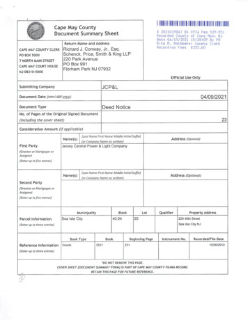
iiiiiiiiiiiiiiiiiiiiii iiiiiiiiiiiiiiiiiiCape May CountyDocument Summary Sheet 2021029367 Bk X976 Pgs 529-551Recorded County of Care flay? NJDate 06/15/2021 15:38:09 By PNRita 11. Rothbersf County ClerkReturn Name and AddressCAPE MAY COUNTY CLERKPC BOX 5000Recording FeesRichard J. Conway, Jr., Esq.Schenck, Price, Smith & King LLP 255.00220 Park Avenue7 NORTH MAIN STREETCAPE MAY COURT HOUSEPO Box 991Florham Park NJ 07932NJ 08210-5000Official Use OnlySubmitting CompanyJCP&LDocument Date (mm/dd/yyyy)04/09/2021Document TypeDeed NoticeNo. of Pages of the Original Signed Document23(includins the cover sheet)Consideration Amount (if appticable)(Last Name First Name Middle Initial Suffix)Address (Optional)Name(s)(or Company Name as written)First PartyJersey Central Power & Light Company(Grantor or Mortgagor orAssignor)(Snter up to five names)(Last Name First Name Middle Initial Suffix)Name(s)Address (Optional)(or Company Name as written)Second Party(Grantee or Mortgagee orAssignee)(Enter up to five names)MunicipalityBlockSea Isle CityParcel InformationLot40.0420Property AddressQualifier220 40th StreetSea Isle City NJ(Enter up to three entries)Book TypeReference InformationDeedsBook3521Beginning PageInstrument No.231(Enter up to three entries)'DO NOT REMOVE THIS PACE.COVER SHEET[DOCUMENT SUMMARY FORM]IS PART OF CAPE MAY COUNTY FILING RECORD. RETAIN THIS PAGE FOR FUTURE REFERENCE.Recorded/File Date12/26/2012
Return Address;Schcnck. Price. Smith & King, LLPAttn; Richard J. Conway. Jr.220 Park Avenue, P.O. Box 991Florham Park. NJ 07932Instrument NumberDEED NOTICEIN ACCORDANCE WITH N.J.S.A. 58:108-13, THIS DOCUMENT IS TO BERECORDED IN THE SAME MANNER AS ARE DEEDS AND OTHER INTERESTS INREAL PROPERTY.Prepared by:[Signature]Richard J. Conway Jr. Esq. Schenck. Price. Smith & King LLP[Print name below signature]Recorded by:[Signature, Officer of County Recording Office][Print name below signature]DEED NOTICEThis Deed Notice is made as of the 9th day of April. 2021, by Jersey Central Power &Light Company,300 Madison Avenue, P.O. Box 1911, Morristown, New Jersey 07962(together with his/her/its/their successors and assigns, collectively "Owner").1. THE PROPERTY. Jersey Central Power & Light Company,located at 300 MadisonAvenue, P.O. Box 1911, Morristown, New Jersey 07962 is the owner in fee simple of certainreal property designated as Block 40.04 Lot 20, on the tax map of the City of Sea Isle City, CapeMay County; the New Jersey Department of Environmental Protection Program Interest Number(Preferred ID)for the contaminated site which includes this property is G000006130; and theproperty is more particularly described in Exhibit A, which is attached hereto and made a parthereof(the "Property").2. REMEDIATION.i. Robert P. Blauvelt, LSRP License No. 575013 has approved this Deed Notice as aninstitutional control for the Property, which is part of the remediation of the Property.
ii. N.J.A.C. 7:26C-7 requires the Owner, among other persons, to obtain a soil remedialaction permit for the soil remedial action at the Property. That permit will contain themonitoring, maintenance and biennial certification requirements that apply to the Property.3. SOIL CONTAMINATION. Jersey Central Power & Light Company has remediatedcontaminated soil at the Property, such that soil contamination remains at certain areas oftheProperty that contains contaminants in concentrations that do not allow for the unrestricted use ofthe Property. Such soil contamination is described, including the type, concentration and specificlocation of such contamination, and the existing engineering controls on the site are described, inExhibit B, which is attached hereto and made a part hereof. As a result, there is a statutoryrequirement for this Deed Notice and engineering controls in accordance with N.J.S.A. 58:10813.4, CONSIDERATION. In accordance with the remedial action for the site which includedthe Property, and in consideration ofthe terms and conditions ofthat remedial action, and othergood and valuable consideration. Owner has agreed to subject the Property to certain statutoryand regulatory requirements that impose restrictions upon the use ofthe Property, to restrictcertain uses ofthe Property, and to provide notice to subsequent owners, lessors, lessees andoperators of the Property ofthe restrictions and the monitoring, maintenance, and biennialcertification requirements outlined in this Deed Notice and required by law, as set forth herein.5A. RESTRICTED AREAS. Due to the presence ofcontamination remaining atconcentrations that do not allow for unrestricted use, the Owner has agreed, as part oftheremedial action for the Property, to restrict the use ofcertain parts ofthe Property (the"Restricted Areas"); a narrative description ofthese restrictions is provided in Exhibit C, whichis attached hereto and made a part hereof. The Owner has also agreed to maintain a list of theserestrictions on site for inspection by governmental officials.58. RESTRICTED LAND USES. The following statutory land use restrictions apply to theRestricted Areas:i. The Brownfield and Contaminated Site Remediation Act, N.J.S.A. 58:108-12.g(I0),prohibits the conversion ofa contaminated site, remediated to non-residential soilremediation standards that require the maintenance of engineering or institutional controls, toa child care facility, or public, private, or charter school without the Department's priorwritten approval, unless a presumptive remedy is implemented; andii. The Brownfield and Contaminated Site Remediation Act, N.J.S.A. 58:108-12.g(12),prohibits the conversion ofa landfill, with gas venting systems and or leachate collectionsystems, to a single family residence or a child care facility.5C. ENGINEERING CONTROLS. Due to the presence and concentration of thesecontaminants, the Owner has also agreed, as part ofthe remedial action for the Property, to theplacement of certain engineering controls on the Property; a narrative description of theseengineering controls is provided in Exhibit C.]
6A. CHANGE IN OWNERSHIP AND REZONING.i. The Owner and the subsequent owners, lessors, and lessees, shall cause all leases,grants, and other written transfers of an interest in the Restricted Areas to contain a provisionexpressly requiring all holders thereof to take the Property subject to the restrictionscontained herein and to comply with all, and not to violate any ofthe conditions ofthis DeedNotice. Nothing contained in this Paragraph shall be construed as limiting any obligation ofany person to provide any notice required by any law, regulation, or order ofanygovernmental authority.ii. The Owner and the subsequent owners shall provide written notice to the Departmentof Environmental Protection on a form provided by the Department and available atwww.ni.gov/srp/forms within 30 calendar days after the effective date of any conveyance,grant, gift, or other transfer, in whole or in part, ofthe Owner's or subsequent owner'sinterest in the Restricted Area.iii. The Owner and the subsequent owners shall provide written notice to the Department,on a form available from the Department at www.ni.gov/srp/forms. within thirty (30)calendar days after the owner's petition for or filing ofany document initiating a rezoning ofthe Property to residential.6B. SUCCESSORS AND ASSIGNS. This Deed Notice shall be binding upon Owner andupon Owner's successors and assigns, and subsequent owners, lessors, lessees and operatorswhile each is an owner, lessor, lessee, or operator ofthe Property.7A. ALTERATIONS,IMPROVEMENTS,AND DISTURBANCES.i. The Owner and all subsequent owners, lessors, and lessees shall notify any person,including, without limitation, tenants, employees oftenants, and contractors, intending toconduct invasive work or excavate within the Restricted Areas, ofthe nature and location ofcontamination in the Restricted Areas, and, ofthe precautions necessary to minimizepotential human exposure to contaminants.ii. Except as provided in Paragraph 7B, below, no person shall make, or allow to bemade, any alteration, improvement, or disturbance in, to, or about the Property whichdisturbs any engineering control at the Property without first retaining a licensed siteremediation professional. Nothing herein shall constitute a waiver ofthe obligation ofanyperson to comply with all applicable laws and regulations including, without limitation, theapplicable rules ofthe Occupational Safety and Health Administration.iii. A soil remedial action permit modification is required for any permanent alteration,improvement, or disturbance and the owner, lessor, lessee or operator shall submit thefollowing within 30 days after the occurrence ofthe permanent alteration, improvement, ordisturbance:
(A)A Remedial Action Workplan or Linear Construction Project notification andFinal Report Form, whichever is applicable;(B)A Remedial Action Report and Termination of Deed Notice Form; and(C)A revised recorded Deed Notice with revised Exhibits, and Remedial ActionPermit Modification or Remedial Action Permit Termination form and Remedial ActionReport.iv. No owner, lessor, lessee or operator shall be required to obtain a Remedial ActionPermit Modification for any temporary alteration, improvement, or disturbance, provided thatthe site is restored to the condition described in the Exhibits to this Deed Notice, and theowner, lessee, or operator complies with the following:(A)Restores any disturbance of an engineering control to pre-disturbance conditionswithin 60 calendar days after the initiation ofthe alteration, improvement or disturbance;(B)Ensures that all applicable worker health and safety laws and regulations arefollowed during the alteration, improvement, or disturbance, and during the restoration;(C)Ensures that human exposure to contamination in excess of the remediationstandards does not occur; and(D)Describes, in the next biennial certification the nature ofthe temporary alteration,improvement, or disturbance, the dates and duration ofthe temporary alteration,improvement, or disturbance, the name of key individuals and their affiliationsconducting the temporary alteration, improvement, or disturbance, the notice the Ownergave to those persons prior to the disturbance.7B. EMERGENCIES. In the event of an emergency which presents, or may present, anunacceptable risk to the public health and safety, or to the environment, or an immediateenvironmental concern, see N.J.S.A. 58:100-2, any person may temporarily breach anengineering control provided that that person complies with each ofthe following:i. Immediately notifies the Department of Environmental Protection ofthe emergency, bycalling the DEP Hotline at 1-877-WARNDEP or 1-877-927-6337;ii. Hires a Licensed Site Remediation Professional (unless the Restricted Areas includesan unregulated heating oil tank)to respond to the emergency;iii. Limits both the actual disturbance and the time needed for the disturbance to theminimum reasonably necessary to adequately respond to the emergency;iv. Implements all measures necessary to limit actual or potential, present or future risk ofexposure to humans or the environment to the contamination;
V. Notifies the Department of Environmental Protection when the emergency orimmediate environmental concern has ended by calling the DBF Hotline at 1-877WARNDEP or 1-877-927-6337; andvi. Restores the engineering control to the pre-emergency conditions as soon as possible;andvii. Submits to the Department of Environmental Protection within 60 calendar days aftercompletion ofthe restoration ofthe engineering control, a report including:(a)the nature andlikely cause ofthe emergency;(b)the measures that have been taken to mitigate the effectsofthe emergency on human health and the environment;(c)the measures completed orimplemented to restore the engineering control; and (d)any changes to the engineeringcontrol or site operation and maintenance plan to prevent reoccurrence of such conditions inthe future.8. TERMINATION OF DEED NOTICE.i. This Deed Notice may be terminated only upon recording a Department-approvedTermination ofDeed Notice, available at N.J.A.C. 7:260 Appendix C,with the office oftheCounty Clerk of Cape May County, New Jersey, expressly terminating this Deed Notice.ii. Within 30 calendar days after recording a Department-approved Termination of DeedNotice, the owner ofthe property should apply to the Department for termination ofthe soilremedial action permit pursuant to N.J.A.C. 7:260-7.9. ACCESS. The Owner,and the subsequent owners, lessors, lessees, and operators agree toallow the Department, its agents and representatives access to the Property to inspect andevaluate the continued protectiveness ofthe remedial action that includes this Deed Noticeand to conduct additional remediation to ensure the protection of the public health and safetyand of the environment if the subsequent owners, lessors, lessees, and operators, during theirownership, tenancy, or operation, and the Owner fail to conduct such remediation pursuant tothis Deed Notice as required by law. The Owner, and the subsequent owners, lessors, andlessees, shall also cause all leases, subleases, grants, and other written transfers of an interestin the Restricted Areas to contain a provision expressly requiring that all holders thereofprovide such access to the Department.10. ENFORCEMENT OF VIOLATIONS.i. This Deed Notice itself is not intended to create any interest in real estate in favor ofthe Department of Environmental Protection, nor to create a lien against the Property, butmerely is intended to provide notice ofcertain conditions and restrictions on the Property andto reflect the regulatory and statutory obligations imposed as a conditional remedial actionfor this site.ii. The restrictions provided herein may be enforceable solely by the Department againstany person who violates this Deed Notice. To enforce violations of this Deed Notice, the
Department may initiate one or more enforcement actions pursuant to N.J.S.A. 58:10-23.11,and N.J.S.A. 58:IOC, and require additional remediation and assess damages pursuant toN.J.S.A. 58:10-23.11, and N.J.S.A. 58:IOC.11. SEVERABILITY. If any court of competentjurisdiction determines that any provision ofthis Deed Notice requires modification, such provision shall be deemed to have beenmodified automatically to conform to such requirements. If a court of competent jurisdictiondetermines that any provision ofthis Deed Notice is invalid or unenforceable and theprovision is of such a nature that it cannot be modified, the provision shall be deemed deletedfrom this instrument as though the provision had never been included herein. In either case,the remaining provisions ofthis Deed Notice shall remain in full force and effect.12A.EXHIBIT A. Exhibit A includes the following maps ofthe Property and the vicinity:i. Exhibit A-1: Vicinity Map - A map that identifies by name the roads, and otherimportant geographical features in the vicinity ofthe Property (for example, USGS Quadmap, Hagstrom County Maps);ii. Exhibit A-2: Metes and Bounds Description - A tax map of lots and blocks as wells asmetes and bounds description ofthe Property, including reference to tax lot and blocknumbers for the Property;iii. Exhibit A-3: Property Map - A scaled map ofthe Property, scaled at one inch to 200feet or less, and if more than one map is submitted,the maps shall be presented as overlays,keyed to a base map; and the Property Map shall include diagrams of major surfacetopographical features such as buildings, roads, and parking lots.12B. EXHIBIT B. Exhibit B includes the following descriptions ofthe Restricted Areas:i. Exhibit B-1: Restricted Area Map — A separate map for each restricted area thatincludes:(A)As-built diagrams of each engineering control, including caps, fences, slurrywalls,(and, if any)ground water monitoring wells, extent ofthe ground waterclassification exception area, pumping and treatment systems that may be required as partof a ground water engineering control in addition to the deed notice;(B)As-built diagrams of any buildings, roads, parking lots and other structures thatfunction as engineering controls; and(C)Designation of all soil and all upland sediment sample locations within therestricted areas that exceed any soil standard that are keyed into one ofthe tablesdescribed in the following paragraph.ii. Exhibit B-2: Restricted Area Data Table - A separate table for each restricted area thatincludes either(A)or(B)through (F):
(A)Only for historic fill extending over the entire site or a portion ofthe site and forwhich analytical data are limited or do not exist, a narrative that states that historic fill ispresent at the site, a description ofthe fill material (e.g., ash, cinders, brick, dredgematerial), and a statement that such material may include, but is not limited to,contaminants such as PAHs and metals;(B)Sample location designation from Restricted Area map (Exhibit B-1);(C)Sample elevation based upon mean sea level;(D)Name and chemical abstract service registry number of each contaminant with aconcentration that exceeds the unrestricted use standard;(E)The restricted and unrestricted use standards for each contaminant in the table;and(F)The remaining concentration ofeach contaminant at each sample location at eachelevation.12C. EXHIBIT C. Exhibit C includes narrative descriptions ofthe institutional controls andengineering controls as follows:i. Exhibit C-I: Deed Notice as Institutional Control: Exhibit C-1 includes a narrativedescription ofthe restriction and obligations ofthis Deed Notice that are in addition to thosedescribed above, as follows:(A)Description and estimated size in square feet of the Restricted Areas as describedabove;(B)Description of the restrictions on the Property by operation ofthis Deed Notice;and(C)The objective ofthe restrictions.ii. Exhibit C-2: Soil Cover: Exhibit C-2 includes a narrative description ofthe clean soilcover and concrete improvements as follows:(A)Description ofthe engineering control;(B)The objective ofthe engineering control; and(C)How the engineering control is intended to function.13. SIGNATURES. IN WITNESS WHEREOF,Owner has executed this Deed Notice as ofthe date first written above.
ATTEST:Jersey Gent/al Power & Light CompanyA corporationof New JerseyBy—/ByDaniel"M unlaWilliam R. BeachCorporate SecretaryDirector, Real Estate for FirstEnergy Service Companyon behalf of Jersey Central Power & Light CompanySTATE OFJVrJ-Sjj I U» V1CSS.:COUNTY OF1 certify that on Aot/I 920 3j , Daniel M. Dunlap personally came before me, andthis person acknowledged under oath, to my satisfaction, that:(a) this person is the Corporate Secretary of Jersey Central Power & Light Company, thecorporation named in this document;(b) this person is the attesting witness to the signing of this document by the proper corporateofficer who is the Director, Real Estate, for FirstEnergy Service Company on behalf of JerseyCentral Power & Light Company, an authorized officer of the corporation;(c) this document was signed and delivered by the corporation as its voluntary act and wasduly authorized;(d) this person knows the proper seal of the coiporation which was affixed to this document;and(e) this persot ned this proof to attest to the truth of these facts.[SignattDaniel M. Dunlap, Corporate SecretarySigned and sworn before me on / pr;j 9 , 2031, Notary PublicCommonweallh of Pennsylvania - Notary SealBrad R.Gillott. Notary Public[P,int nama/ tSif d CountyMy commission axpirs s February 11,2023Commission number 1196829Member,Pennsyivenia Asaociatiort of Notaries
%f\ !A4, X . 4f."s . X.\* / **;V'I-VJ\ \\ t\J.-.fV:ieeS vistoM - eJnsvJyenne; to rtflsewnommoOoijdu b pM 4}oi!]c .n bsi8yinuoO bnsteiofl WCSOS,rf yieindp eiiqxe n'oipplmmoo yMeS8 8 9dmunno 8ei nmoOeeiictokl lo noiJsboBfiA Blnsvivenns 1 ,i0(}rn»M
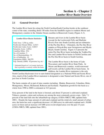
J ' i'iVJw Ir; * '. ;«\v*'. LUI A \BAY:'''\ » v'"t.r0§;l il&- AI. \m/ '-'v:';y '' ' — c/KAK::3C \\\. - -. / ?Cx L V StRltaJ«r -V- ".-ll - -,A?'' \\ i s -i T-UJi/SesL Isle City;:; r IIslai dH- A .7#f / \V— - V?Ak. - \-"J ifIf ylibiSOURCE:1. USGS TOPOGRAPHIC MAP ACCESSED VIA ARCGIS ONLINESERVICES.SCALE. FEETDeed Notice - 220 40th StreetSea Isle City Former MGPnoil)Sea Isle City, New JerseySRP PI #0000006130VICINITY MAPSEA ISLE CITY TAXBLOCK 40.04 LOT 20220 40TH STREETSEA ISLE CITY, NJCurrent OwnerJersey Central Power & Light CompanyMorristown, New JerseyJ:\Projects\JCP&L\Sea Isle Clty\2019 Deed Notice\220 40th-Site Location.mxdProject 1610583December 2020Exhibit A-1
Sea Isle City former MGPExhibit A-2.1 aDeed NoticeExhibit A-2.1 220 40th StreetUSA HK AOk A&s.Blocfc40.04,Lot20/W\ VARGOVimJ ASSOCIATESSurveying and MappingPROPERTY DESCRIPTIONTAX LOT 20,BLOCK 40.04CITY OF SEA ISLE CITYCAPE MAY COUNTY,NEW JERSEYALL THAT CERTAIN tract or parcel ofland situate in the city of Sea Isle City, County of Cape Mayand State of New Jersey, bounded and described as follows:BEGINNING at a point for a comer in the southerly line of 40* Street(60' wide)at the division linebetween tax lots 20 and 21, Block 40.04, said beginning point having New Jersey State PlaneCoordinate System(NAD '83) grid values ofN 118,134.70 feet, E 437,299.38 feet; thence1. South 32 44' 19" West, along said division line between tax lots 20 and 21, block 40.04, adistance of 110.00 feet to a point for a comer in the division line between tax lots 8, 9,20 and21, block 40.04; thence2. North 57 15' 41" West, along the division line between tax lots 8 and 20, block 40.04, adistance of 50.00 feet to a point for a comer in the division line between tax lots 8,14,20 and28, block 40.04; thence3. North 32 44' 19" East, along the division line between tax lots 20 and 28, block 40.04, adistance of 110.00 feet to a point for a comer in the southerly line of40 Street; thence4. South 57 15'41" East, along said southerly line of40* Street, a distance of50.00 feet to thepoint and place of BEGINNING.CONTAINING within said bounds 5,500 Square Feet(0.126 acres), more or less.This description is prepared in accordance with a map entitled "Map of Survey, Tax Lot 20, Block40.04, City of Sea Isle City, Cape May County, New Jersey", prepared by Vargo Associates, datedDecember 19,2019, and noted thereon as project number 02219-20.December 19,2019Prepared by:gri/,Robert E. VargoProfessional Land SurveyorNJ License #GS 432612771 Delsea Drive PO Box 647 Franklinvilie, NJ 08322P 856.694.1716 * F 856.694.3102 govargo.com
Exhibit A-2.lb#VARGOASSOCIATESSurveying and MappingDEED RESTRICTIONPART OF TAX LOT 20,BLOCK 40.04SEA ISLE CITY,CAPE MAY COUNTY,NEW JERSEYALL THAT CERTAIN tract or parcel of land and premise, situate in the City of Sea Isle City, County of CapeMay and State ofNew Jersey, bounded and described as follows:BEGINNING at a point in the southerly line of40th Street(60 feet wide), said point being in the division linebetween tax lots 20 & 21,block 40.04, said beginning point having New Jersey State Plane Coordinate System(NAD '83)grid values ofN 118,134.70 feet, E 437,299.38 feet; thence:1. South 32 44'19" West, along said division line, a distance of 33.81 feet to a point in the same;thence2. North 57 03'03" West,passing through tax lot 20, block 40.04,a distance of50.00 feet to a point in thedivision line between tax lots 20 and 19, block 40.04; thence3. North 32 44'19" East, a distance of 33.63 feet to a point in the southerly line of40th Street; thence4. South 57 15'41" East, along said line of40th Street, a distance of50.00 feet to the point and place ofBEGINNING.CONTAINING within said bounds 1,686 square feet, more or less.December 9,2020Prepared by:Robert E. VargoProfessional Land SurveyorN.J. License #432612771 Delsea Drive PO Box 647 Franklinvlile, NJ 08322P 856.694.1716 F 856.694.3102 govargo.com
P.O.B.DEED RESTRICTION(60' WIDE)S57'15'4r'ECONCRETE WALKFNN 118.134.70E 437.299.3850.00'ON.S57'13'41't 50.00'' I fe I / Hi/ I;i/I/ 3///7-/'OfER-!lEAD PECK/I 'n ;ll\ ;§l\\r- '' / \r\/ DEED RESTRICTION; AREA 1.686 S.R.IIItI1 : 1 1 1TAX LOT 19 jN5r03'03'W 80.00'TAX BLOCK 40.04LOT 20/ 2203 STORYFRAMEDUPLEX! l IIDECK\I VINYL J'FENCE I,SHOWEROVER-iHEAD DECK s'HOWERSTALL2 STORYFRAME BLDC. &GARAGECONCRETE RETAINING\ WALL0.2' FNC \ METAL F :NCE ALONGTOP OF WALLQ, t.O,",i/N57 15 41 WO-cn .n/T50.00CONCRETE RAMPVINYL FENCE ALONGTOP OF WALLBASE MAP OBTAINED FROM SURVEY OF PLAN OF DEEDRESTRICTION TAX LOT 20, BLOCK 40.04, SEA ISLE CITY. CAPEMAYCOUNTY, NEWJERSEY, PREPARED BY ROBERT E.VARGO, P.L.S. VARGO ASSOCIATES, INC., NEWJERSEY, N.J.LAND SURVEYOR LIC. NO. GS 43261, SCALE: 1" 20', DATEDDECEMBER 2. 2020.SCALE, FEETDeed Notice - 220 40th StreetPROPERTY MAPSea Isle City Former MGP SiteSEA ISLE CITY TAXSea Isle City, New JerseyBLOCK 40.04 LOT 20SRP PI# G000006130Jersey Central Power & Light CompanyMorristown. New JerseyGEIProject 1610583220 40TH STREETSEA ISLE CITY. NJDecember2020Exhibit A-2.2\\mtl-pzcc-1\ P:\Project\JCP&L\SIC\1610583 D6ed No{ice 220 40th Stree{.elwg - 12/14/2020
4 0 T HSTRE\ET( e 0 W S D E) 'LEGEND:' A liii'-- i.PROPERPi'LINE - CONCRETE CURBCONCRETE WALKSANITARY SEWER LINEOVERHEADLINEOVER-HEAD DECKLOTWATER METER LINE20# 2203 STORYFRAME DWG.\ NOTES:BASE MAP OBTAINED FROM SURVEYOF TAX LOT 20OVER-HEAD DECKBLOCK 40.04, SEA ISLE CITY, NEW JERSEY, PREPAREDBY ROBERT E. VARGO, L.S., VARGO ASSOCIATES, INC.,NEW JERSEY. N.J. LAND SURVEYOR LIC. NO.43261 .SCALE: 1" 30'. DATED DECEMBER 19, 2019HORIZONTAL DATUM IS N.A.D, 1983 AND VERTICALDATUM ISN.A.V.D 1988.BLOCK 40.04SCALE. FEETDeed Notice - 220 40lh StreetPROPERTY MAPSea Isle City Former MGPSEA ISLE CITY TAXSea Isle City. New JerseyBLOCK 40.04 LOT 20SRPPI#G000006130urrent OwnerJersey Central Power & Light CompanyMorristown, New JerseGEIProject 1610583220 40TH STREETSEA ISLE CITY. NJDecember2020Exhibit A-3\\mtl-pzcc-1\ P;\Project\JCP&L\ IC\ xhlbit A-3 Property Maps.dwg - 8/20/2020
Exhibit B-1(a)220 40TH STREET PROPERTYBOUNDARYRESTRICTED AREALOT 20A # 220SUBSURFACE SOIL SAMPLESABOVE THE NJDEP RESIDENTIALDIRECT CONTACT SOIL3 STORYFRAME DWG,REMEDIATION STANDARD(RDCSRS)CONCRETE CURB—GGAS LINESANITARY SEWER LINEhti l lOVERHEAD LINEWATER METER LINE—CONCRETE IMPROVEMENTr,-ASTONE IMPROVEMENT; V'iBLOCK 40.04 YyITTj,' L--' ,NOTES:1.Soil sample compared to NJDEP RDCSRS;Remediation Standard N.J.A.C. 7:26D, May 2013;Amended September 2017.SCALE, FEETDeed Notice - 220 40th StreetSea Isle City Former MGP SiteRESTRICTED AREA MAPSEA ISLE CITY TAXSea Isle City. New JerseyBLOCK 40,04 LOT 20SRPPI#G000006130urrent OwnerJersey Central Power & Light CompanyMorrlstown, New JerseGElProject 1610583220 40TH STREETSEA ISLE CITY, NJDecember 2020Exhibit B-1 (a)\\MTL3L-LW1NK P:\Project\JCP&L\SlC\1610583 DEED NOTICE SEA ISLE,dwg - 7/15/2020
Morristown, NewJerseJersey Central Power & Light CompanyDecember 2020Exhibit B-1(b)\\mtl-p2cc-1\ P:\Project\JCP&L\SIC\1610583-Deed Notice Detalls.dwg - 1/2/2020Project 1610583220 40TH STREETSEA ISLE CITY. NJSRP PI #0000006130GEISEA ISLE CITY TAXBLOCK 40.04 LOT 20Sea Isle City Former MGPSea Isle City, New JerseyCurrent OwnerRESTRICTED AREA DETAILSDeed Notice - 220 40th Street2\ DETAILMtv STONE IMPROVEMENTMtV CONCRETE IMPROVEMENTSOIL COVER:STONE IMPRpyEMENTJ Ntv' ''T\ DETAILSOIL COVERCONCRETE IMPROVEMENT
SRSCAS91-20-32172171717NRDCSRSGEI Consultants, Inc.PAH - Polycyclic aromatic hydrocarbonsJ - Constituent identified; value Is approximatedU - Not detected above the reporting limit shownmg/kg - milligrams per kilogramft0.148 U0.148 U0.148 U0.148 U0.100 J9.791/18/2010B-4060.353 U0.353 U0.353 U0.353 U0.170 J23.33/10/2010ft-4.8-5.3B-406 (9.5-10)B-4083/11/2010ft-4.8-5.3B-408{9.5-1D)July 2020Exhibit B-2-1 Restricted Area Data Table Block 40.04 Lot 20H:\TECH\project\JCP&L\Sea Isle CltytRemediatlon 2014-2015\218-220 RAR\Deed Notices\220 40th Street\Exhibit B\IS BOLD Indicates that the detected result value exceeds RDCSRSRDGSRS - Residential Direct Contact Soil Remediation StandardNRDCSRS - Non-Residential Direct Contact Soil Remediation oranthenePAHs(mg/kg)NaphthaleneSample DateElevation Unit(amsl)-1.8-2.3Start ElevationEnd ElevationB-298B-298(6.5-7)Sample NameLocation NameSea Isle City, New Jersey220 40th StreetBlock 40.04, Lot 20Deed NoticeExhibit B-2: 220 40th Street Soil Sample Analytical Results
Exhibit CSea Isle City Former MGP SiteBlock 40.04, Lot 20Sea Isle City, Cape May CountyExhibit C(Includes)Exhibit C-1- Narrative Description of Institutional ControlExhibit C-2- Narrative Description of Engineering Controls
Exhibit C-1Exhibit C-1Deed NoticeBlock 40.04, Lot 20Sea Isle City, Cape May County, New JerseyNarrative Description of Institutional Control for Restricted Area of Block 40.04. Lot 20Institutional controls are hereby placed on a portion of the property at 220 40* Street, TaxBlock 40.04, Lot 20 as identified on the tax map of Sea Isle City, New Jersey as shown on ExhibitB-l(a) and as further described in this deed notice. A description of the controls and maintenanceprocedures applicable to the Restricted Area are presented below.(A)Description and Estimated Size of the Restricted AreaThe property {as set forth on Exhibit A)is located on the site identified as 220 40* StreetBlock 40.04, Lot 20 on the tax map of Sea Isle City. The property is bounded by the 40* Street right of way to the northeast,to the southeast by a residential property identifiedas 218 40 * Street Block 40.04 Lot 21,to the southwest by the Sea Isle City MunicipalBuilding at 233 John F. Kennedy Boulevard Block 40.04 Lot 9, and to the northwest by aresidential duplex identified as 222 40** Street Block 40.04, Lots 27 and 28. The northernportion of the parcel is designated as restricted use due to soil Impacts associated withmanufactured gas plant(MGP)o
Book Type Book Beginning Page Instrument No. Recorded/File Date Deeds 3521 231 12/26/2012 'DO NOT REMOVE THIS PACE. COVER SHEET [DOCUMENT SUMMARY FORM] IS PART OF CAPE MAY COUNTY FILING RECORD. RETAIN THIS PAGE FOR FUTURE REFERENCE. Instrument Number Return Address; Schcn