Transcription
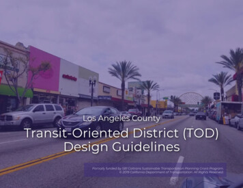
Los Angeles CountyTransit-Oriented District (TOD)Design GuidelinesPartially funded by SB1 Caltrans Sustainable Transportation Planning Grant Program. 2019 California Department of Transportation. All Rights Reserved.
PART IACounty of Los Angeles TOD Design GuidelinesPART IIAAcknowledgmentsCounty of Los Angeles Department of Public WorksGruen AssociatesHank HsingCivil Engineer, Project ManagerAdam Maleitzke, AICPDirector of PlanningElaine KunitakeEngineerElaine Carbrey, AIA, AICPAssociate PartnerRazmik MartirosyanAdministrative AidDRAFTOrlando GonzálezSenior Planner/DesignerKamille Parks, AICP CandidateUrban Planner/DesignerCounty of Los Angeles Department of RegionalPlanningMi KimSupervising Regional PlannerNorman Ornelas Jr.Regional PlannerJames DrevnoRegional PlannerKOA (Lead Consultant)Joel FalterPrincipalBrian Marchetti, AICPProject Manager, Senior Transportation Planner2DTAKuda WekweteSenior Vice PresidentDonna SeguraVice PresidentKatherine Padilla & AssociatesKatherine Padilla-Otanez, MBA, CCPM, DVBE,MBEOwner and Managing PrincipalJo RoselThelma HerreraBCDEPART IIIPART IVAA
PART ICounty of Los Angeles TOD Design GuidelinesAPART IIABCDEPART IIIPART IVAADRAFTLos Angeles CountyTransit-Oriented District (TOD)Design GuidelinesPartially funded by SB1 Caltrans Sustainable Transportation Planning Grant Program. 2019 California Department of Transportation. All Rights Reserved.3
PART IACounty of Los Angeles TOD Design GuidelinesPART IIABCDPART IIIPART IVAAETable of ContentsPART I: OverviewPART II: Design GuidelinesPART IPART IIPART IIPART IISECTIONSECTIONSECTIONSECTIONAAIntroduction 9Executive Summary 10Introduction 11Goals of the Guidelines 12Planned Rail Lines and StationAreas 13Existing Plans and Policies 14The Need for RegionalCollaboration 16Benefits of TOD 17How to Use This Document 184BCDRAFTGeneral Guidelines Building Typologies andStation Area TypologiesGuidelinesand Guidelines4735 21 Mix of Uses and Densities/Intensities 22Built Form and ArchitecturalDesign 24Open Space and Urban Design 28Mobility and Complete Streets 30Identify Your Station Area 36Urban Mixed-Use TOD 40Urban Residential TOD 41Mixed-Use Job Center TOD 42Institutional TOD 43Regional Retail Center TOD 44Open Space-Dominated TOD 45How to Use the Building DesignGuidelines 48Select Appropriate BuildingTypologies 49Lower Density 50Medium Density 56Higher Density 62
PART IACounty of Los Angeles TOD Design GuidelinesPART II: Design Guidelines (cont.)PART IIAPART III: Case StudyBCDEPART IIIPART IVAAPART IV: AppendixPART IIPART IIPART IIIPART IVSECTIONSECTIONSECTIONSECTIONDAEDRAFTComplete StreetOpen Space and PublicGuidelinesRealm Guidelines 69 77How to Use the Open Space/Public Realm Guidelines 70How to Use the Complete StreetsDesign Guidelines 78Open Space Typologies 71Street Design 81Intersections 85Streetscape Infrastructure 90Amenities 93Other 95AOpportunities andConstraints AnalysisExisting ConditionsReport 117This section will be 99completedfollowing publicPublic Outreach 100input from Stakeholder andLand Use Profile 108Community MeetingsThis section will becompleted following publicinput from Stakeholder andCommunity Meetings Urban Design Profile 110Mobility Profile 1125
PART ICounty of Los Angeles TOD Design GuidelinesAPART IIADRAFTTHIS PAGE HAS BEEN INTENTIONALLY LEFT BLANK6BCDEPART IIIPART IVAA
PART I: Overview
County of Los Angeles TOD Design GuidelinesJump to“ImportantSections”PART IAPART IIADRAFTTHIS PAGE HAS BEEN INTENTIONALLY LEFT BLANK8BCDEPART IIIPART IVAA
County of Los Angeles TOD Design GuidelinesJump to“ImportantSections”PART IAPART IIASECTION IADRAFTBCDEPART IIIPART IVAAIntroduction9
County of Los Angeles TOD Design GuidelinesJump to“ImportantSections”PART IAPART IIA01 Executive SummaryDRAFTIN PROGRESS10BCDEPART IIIPART IVAA
Jump to“ImportantSections”County of Los Angeles TOD Design GuidelinesPART IAPART IIABCDEPART IIIPART IVAA02 IntroductionThe Los Angeles (LA) County General Plan Transit-Oriented Districts(TOD) Program was developed to enable transit-supportive uses andinfrastructure in unincorporated communities near existing and newtransit facilities.The Program was developed to update planning of unincorporatedcommunities near existing and new transit facilities. A half-mile radiusaround each potential new transit station is used for a preliminary studyarea, which is then refined later as part of a seperate Specific Plan effort.The LA County TOD Design Guidelines (TOD Guidelines) establish aframework for promoting high quality, affordable housing, increasedmobility and accountability, improved and safe infrastructure, increasedhousing choices, healthy benefits through walking and biking, andreduced greenhouse gas (GHG) emissions. The Guidelines supplementthe provisions of the General Plan and local zoning. They will also serveas a basis for developing Specific Plans for each station area as thecorridors are implemented, a process that will offer the community morein-depth community outreach and analysis. Formulation of a market and economic development strategy,which includes zoning suggestions and identify future needsassessment involving capital improvement opportunities andstrategies for the Atlantic/Whittier Station Area. Identification and analysis of potential funding sources for TOD andactive transportation. Establishment of the potential for Tax Increment Financing (TIF)districts (Enhanced Infrastructure Financing Districts, CommunityRevitalization and Investment Authority, etc.).DRAFTThe TOD Guidelines planning process includes the following: Review of existing conditions for pedestrians, motorists, bicyclistsand transit users in the TOD area such as demographics, zoningconditions, parking, circulation patterns, and transit services/facilities. Evaluation of applicable County policies and plans. (SeeExisting Conditions Report in Appendix) Use of the Atlantic/Whittier Station in East Los Angeles as a testcase for the Design Guidelines, building in a robust public outreachprocess. Extrapolate those findings into the Guidelines to considerfor future potential rail stations. Establishment of TOD guidelines generally for the station area,as well as specific interventions and associated design guidelinesand best practices through a review of best practices on land use,urban design, transportation, and architecture (setbacks, heights,streetscape view, etc). Development and implementation of a community engagementstrategy to encourage public participation, and stakeholderinvolvement, ownership, and buy-in.11
County of Los Angeles TOD Design GuidelinesJump to“ImportantSections”PART IAPART IIA03 Goals of the GuidelinesThese Transit-Oriented District (TOD) Design Guidelines are a tool toimplement the Los Angeles County (LA County) General Plan and areintended to guide the design of new development and infill projects forTODs in the unincorporated areas of LA County. The preparation of futureSpecific Plans and these Guidelines include recommendations, bestpractices, and precedents for high-quality transit-oriented development.The goals of these Design Guidelines are those of the County’s GeneralPlan Transit-Oriented District Program, which have been paraphrasedbelow:12345612Increase walking, bicycling, and transit;DRAFTFacilitate compact, mixed-use development;Increase economic activity;Facilitate the private investment of infrastructureimprovements;Streamline the environmental review process for futureinfill development projects;{Additional goals to be added later from the outreachprocess}BCDEPART IIIPART IVAA
County of Los Angeles TOD Design GuidelinesJump to“ImportantSections”PART IPART IIAABCDEPART IIIPART IVAA04 Planned Rail Lines and Station AreasSince 1990, the Los Angeles County Metropolitan TransportationAuthority (Metro), responsible for the County transportation system, hasimplemented premium rail and busway lines including the Blue line,the Red Line, Purple Line, Metro Green Line, Metro Gold Line, the MetroOrange Line, Metro Silver Line and the Metro Expo Line. These transitservices are provided in addition to the existing and planned bus system.With the passing of Measure M in 2018, the voter-approved half-centsales tax, Metro is currently evaluating locations for three transit corridorsand extensions of existing transit corridors through unincorporatedLA County. Along these corridors, there are five additional rail stationsin unincorporated LA County, and another five rail stations locatedin neighboring jurisdictions that include unincorporated LA Countyland within a half-mile radius. These corridors and stations include thefollowing:ADRAFTEastside Transit Corridor Phase 2Stations: BBAtlantic/WhittierSanta AnitaPeckThe Shops at MontebelloNorwalkLambertCommercePurple Line ExtensionACMeasure M Transit ProjectsSource: LA County Department of Regional PlanningStations: CWestwood/VA HospitalWestwood/UCLAWest Santa Ana BranchStations: Florence/Salt LakeThese three corridors are shown in the figure at right. Maps of allproposed station areas can be found in the Appendix.These potential new rail stations present the County with an opportunityto enhance and transform communities through public and privateinvestment in all types of housing (including affordable), retail, office,open-space, other community amenities and infrastructure. In addition,active transportation and first/last-mile projects around new transitstations could be implemented with each jurisdiction’s Measure Mcommitment to fund 3% of the total project cost, among other potentialfunding sources. The Design Guidelines can be applied to existing andfuture station areas with unincorporated LA County land.13
Jump to“ImportantSections”County of Los Angeles TOD Design GuidelinesPART IAPART IIABCDEPART IIIPART IVAA05 Existing Plans and PoliciesThere are several existing regulatory documents in place which affectthe development of existing and future TODs in unincorporated LosAngeles County. These documents are summarized briefly below:Plans and Policies all Unincorporated Los AngelesCountyLos Angeles County General Plan (2015)The 2035 Los Angeles County General Plan, adopted in 2015, providesa policy framework for guiding jobs and housing growth, within theunincorporated areas of Los Angeles County. See the Appendix for a fullsummary.Housing Element (2014)The Housing Element of the General Plan determines the existing andprojected housing needs of the unincorporated areas, establishes goals,policies and implementation programs that guide decision making onhousing needs, and implements actions that encourage the privatesector to build housing. See the Appendix for a full summary.Los Angeles County CodeThe Complete Streets Policy aims to ensure that streets form acomprehensive and integrated transportation network promoting safeand convenient travel for all users while preserving flexibility, recognizingcommunity context, and using design guidelines and standards thatsupport best practices. See the Appendix for a full summary.Los Angeles County Model Design Manual for LivableStreets (2011)The Los Angeles County Model Design Manual is based on completestreets principles that design streets for people of all ages and physicalabilities and accommodate all travel modes. See the Appendix for a fullsummary.Los Angeles County Draft Vision Zero Action Plan (2019)DRAFTThe Subdivision Ordinance (Title 21 of the Los Angeles County Code)generally regulates the internal design of streets, lots, public utilitiesand other similar infrastructure in each new subdivision. The ZoningOrdinance (Title 22 of the Los Angeles County Code) regulates singlelot restrictions such as use, height, and requirements for setbacks andparking. See the Appendix for a full summary.Los Angeles County Bicycle Master Plan (2012)The County Bicycle Master Plan guides the development andmaintenance of a comprehensive bicycle network and set of programsthroughout the unincorporated communities of the County of LosAngeles for 20 years (2012 to 2032). See the Appendix for a full summary.Los Angeles County TOD Access Study (2013)The purpose of the TOD Access Study is to assess the station accesscapacity and needs within nine proposed TODs in Los Angeles County.The proposed stations are part of the Green, Blue and Gold Lines withthe Sierra Madre Villa Gold Line Station being the only Gold Line stationstudied. See the Appendix for a full summary.14Metro Complete Streets Policy (2014)The County of Los Angeles does not have an adopted Vision Zeroprogram, however the County has released a draft Vision Zero ActionPlan to guide a new traffic safety initiative focused on eliminating trafficrelated deaths on unincorporated County roadways by 2035. See theAppendix for a full summary.Parks Needs Assessment (2016)The Countywide Parks Needs Assessment was designed to quantify theneed for parks and recreational resources. See the Appendix for a fullsummary.On-Demand Personal Mobility Devices Pilot Program (2019)The County of Los Angeles will be implementing the On-DemandPersonal Mobility Devices (Devices) Pilot Program to supporttransportation alternatives, reduce greenhouse gases, and connectto transit. Devices will allow on-demand shared personal mobilitycompanies to operate on unincorporated County streets which will assistthe County in the management of its transportation network. See theAppendix for a full summary.
County of Los Angeles TOD Design GuidelinesJump to“ImportantSections”PART IAPART IIABCDEPART IIIPART IVAAPlans and Policies for only the Atlantic/WhittierStation AreaEast Los Angeles 3rd Street Plan (2014)The 3rd Street Plan is a vision plan that sets forth a comprehensive setof strategies and design guidelines consistent with the goals, objectives,and policies of the County of Los Angeles General Plan and the East LosAngeles Community Plan. See the Appendix for a full summary.East Los Angeles 3rd Street Form-Based Code Specific Plan(2014)This Form-Based Code Specific Plan (Form-Based Code or ordinance) isestablished as the primary means to implement the East Los Angeles3rd Street Plan. See the Appendix for a full summary.East LA Community Plan (1988)DRAFTThe community plan establishes a framework of goals, policies andprograms that is designed to provide guidance to those makingdecisions affecting the allocation of resources and the pattern, density,and character of development in East Los Angeles. See the Appendix fora full summary.Other Related PlansSCAG 2016-2040 Regional Transportation Plan/SustainableCommunities Strategy (2016 RTP/SCS)The Regional Transportation Plan/Sustainable Communities Strategy(2016 RTP/SCS or Plan) is a long-range visioning plan that integratesland use and transportation, and balances future mobility and housingneeds with economic, environmental and public health goals. See theAppendix for a full summary.National Association of City Transportation Officials(NACTO) Urban Street Design GuideThe Urban Street Design Guide provides the blueprint to NACTO’smission of making streets safer, more livable, and more economicallyvibrant. See the Appendix for a full summary.15
County of Los Angeles TOD Design GuidelinesJump to“ImportantSections”PART IAPART IIABCDEPART IIIPART IVAA06 The Need for Regional CollaborationRegional collaboration is paramount for the success of the TOD Programand Design Guidelines to achieve continuous safe and comfortableconnectivity (walking and bicycling) to the existing and proposed transitstations requires collaboration with cities within the half-mile area.Shared JurisdictionsEach of the proposed station areas include significant land area outsideof unincorporated LA County which are subject to the jurisdiction of localcities. At a minimum, the County should extend invitations to commenton the development of related guidelines, active transportation plans,and specific plans to residents and other stakeholders in adjacentjurisdictions within the half-mile radius. The jurisdictions which haveland area within the proposed half-mile station areas are:City of South El MonteThe City has land area which comprises the majority of the The Shops atMontebello half-mile station area. The station is located in Montebello.City of CommerceThe City has minimal land area in the Atlantic/Whittier half-mile stationarea and land area which comprises the vast majority of the Commercehalf-mile station area. The proposed Atlantic/Whittier station is locatedin unicoprorated LA County but the proposed Commerce station islocated in the City of Commerce.City of Santa Fe SpringsThe City has some land adjacent to the Norwalk half-mile station areaand has land area which comprises the majority of the Lambert halfmile station area. The proposed Lambert station is located in Santa FeSprings.City of Huntington ParkThe City has land area which comprises the majority of the Florence/16City of Los AngelesThe City has minor land area in the Westwood/VA Hospital half-milestation area and a considerable amount of land area in the Westwood/UCLA station area. The proposed VA Hospital station is located inunincorporated LA County but the proposed UCLA station is located inthe City of Los Angeles.Neighboring CitiesIn addition, collaboration with neighboring cities in planning andimplementing more transit-supportive land uses with intensities anddensities will be necessary for the TOD’s success at realizing the benefitsof TOD.DRAFTThe City has land area which comprises a significant portion of the SantaAnita and Peck half-mile station areas. The proposed Santa Anita stationis located in unicorporated LA County but the proposed Peck station islocated in South El Monte.City of MontebelloSalt Lake half-mile station area. The proposed station is located inHuntington Park.
County of Los Angeles TOD Design GuidelinesJump to“ImportantSections”PART IAPART IIABCDEPART IIIPART IVAA07 Benefits of TODCatalyst for economic development: TODs can act as a catalyst fornearby properties to invest in development and take advantage of thehigher land use density, customer base and walkable TOD community.Health benefits: By providing more opportunities for walking andbicycling, TODs areas can lower rates of obesity, heart attacks, and otherchronic health conditions.Redevelopment: TODs can be used to redevelop vacant or underutilizedproperties and declining auto-oriented neighborhoods.Enhanced sense of community: Bringing more people and businessescloser in a pedestrian environment creates an activity hub, as TODsenhance community engagement and activity.Increased property value: TODs can be used to revitalize the area within1/2 mile of the station resulting in increased property values.Reduced per capita infrastructure costs: TODs help reduceinfrastructure costs due to compact and infill development that, ona per capita basis, is less expensive to service relative to auto-baseddevelopment.Enhanced public safety: Creating more active pedestrian places usedthroughout the day and evening promotes natural surveillance, whichcan lead to lower crime rates.Quality of life: Reducing the driving time for long automobilecommutes, enables commuters to repurpose this time or other activities.Revenue for transit systems: Increased ridership leads to additionalrevenues for transit service.DRAFTReduced household spending: By reducing auto, parking and travelcosts, TODs contribute to an expansion of household net income, whichcan instead be invested in the community. Households that use transitand reduce the need for one car can save up to 1,000 per car per year(SCAG RTP/SCS Performance Measures, 2015).Increased transit ridership: By decreasing driving and creating awalkable environment, TODs will increase transit ridership and mayresult in less roadway congestion with new development.Improved air quality and energy consumption: Decreased auto tripslead to lower emissions which results in improved air quality.Conservation of land and open space: TODs are compactdevelopments, and therefore, consume less land than lower-intensity,auto-oriented development.Expanded housing and employment choices: TODs provide a diversityof housing and employment types in conveniently close proximity to thetransit station.Greater mobility choices: By creating activity nodes linked by transit,TODs increase mobility options in congested areas. Young people, theelderly, those without cars or not wanting to drive also have mobilityoptions.17
Jump to“ImportantSections”County of Los Angeles TOD Design GuidelinesPART IAPART IIABCDPART IIIPART IVAAE09 How to Use This DocumentWho Am I?What do I want to accomplish?What can I do?Important SectionsII A II B II C II D II E III A*Elected/AppointedOfficial Improve city through policies and/or physicalimprovements Meet the needs of constituents Understand existing conditions of station area Approve a project Public-private partnership (P3)City/CountyPlanner Contribute to a successful and impactfulproject Engage with developers applicants Develop TOD-supportive policies Understand existing conditions of station area Respond to residents, business, and/or localorganizations needs Manage a project Recommend a project Apply for grant for publicimprovements Recommend approval of a projectLocalBusinessOwner Buy property Develop a project Rehabilitation of storefronts/buildings Provide bicycle and transitsupportive amenitiesDeveloper/PropertyOwner Build a project that benefits the community Generate profit Develop more effectively integrated projectsinto station areas Understand characteristics of my station area CommunityOrganizer /Activist Lead community outreach efforts Advocate for transit-supportiveprojectsLocalResident Learn about urban planning best practices Define a project need Improve my neighborhood Provide feedback on a project Preserve and enhance the character and transit Advocate for transit-supportivesupportive qualities of my neighborhoodprojects Understand characteristics of my station areaArchitecture/ Planning /LandscapeConsultantDRAFTBuild a project that benefits the communityGenerate profitGrow customer baseRetain and build upon local revenuesUnderstand characteristics of my station areaImprove neighborhood for local residentsChampion engagement and social changeUnderstand characteristics of my station areaImplement walkable neighborhoods Learn about new planning trends, tools, andmetrics Design a project that is both transit, pedestrian,and cyclist friendlyAcquire key sitesDevelop a projectPublic-private partnership (P3)Work with county to entitle, permit,and seek approval for projects Design compact infill TOD projects Incorporate amenities thatsupport the use of transit/improvewalkability in my projects Design active transportationimprovements* Please Refer to Section III for additional considerations for the Atlantic/Whittier station area18XXXXXXXXXXXXXXXXXXXXXXXXXXXXXXXXXXXXX
PART II: Design Guidelines
County of Los Angeles TOD Design GuidelinesJump to“ImportantSections”PART IAPART IIADRAFTTHIS PAGE HAS BEEN INTENTIONALLY LEFT BLANK20BCDEPART IIIPART IVAA
County of Los Angeles TOD Design GuidelinesJump to“ImportantSections”PART IAPART IIABCDEPART IIIPART IVAADRAFTSECTION IIAGeneral Guidelines21
County of Los Angeles TOD Design GuidelinesJump to“ImportantSections”PART IAPART IIABCDEPART IIIPART IVAA01 Mix of Uses and Densities/IntensitiesCompact development with a mix of uses places more people in walkingdistance of the station. This concentration fosters walking, bicycling,and shared modes between uses to minimize auto trips and pollution.Introducing transit-supportive uses to a TOD can further support multimodal transportation and an active, vibrant neighborhood. Transitsupportive uses include retail, restaurants, outdoor cafes, grocery stores,bookstores, neighborhood services, daycare, multi-family residential,affordable housing, offices, entertainment, hotel, medical clinics,recreational facilities, fitness clubs, educational facilities, regionalhospitals, and other uses that cater to the needs of transit users,residents and employers.Pasadena, CA; GuidelinesMix of UsesRecommendedDRAFT1Market Rate Housing: Remove barriers to the construction ofmarket-rate housing.2Affordable Housing: Develop innovative strategies to introduceaffordable housing into a TOD: Remove maximum density and height restrictions foraffordable housing projects and affordable housing inmixed-use developments with improved transportationinfrastructure and public amenities/benefits. Preserve and increase the amount of affordable housing bytechniques such as rent stabilization, inclusionary zoningordinances, development of County-owned land, and Countyprograms now in effect.3Proportion of Uses: Vary the proportion of mix of uses in a halfmile area depending on the characteristics of an individual area.4Transit Supportive Uses: Provide transit-supportive uses thatgenerate high pedestrian activity support multiple trips, fosteran active environment throughout the day and increase transitridership.East Los Angeles, CA; Source: GruenNot RecommendedLos Angeles, CA; 22Source: GruenRecommendedSource: GoogleLos Angeles, CA; Source: Gruen
County of Los Angeles TOD Design Guidelines5Economic Development: Balance new economic developmentwith support for local business and current residents.6Tailor Designs to Reflect Uniqueness of an Area: Vary the designcharacter of developments based on the land use and urbandesign theme envisioned, unique characteristics of a specificgeographic location, and sensitive existing features and context.Jump to“ImportantSections”PART IAPART IIABCDEPART IIIPART IVAANot RecommendedCompact Development7Joint Development: Coordinate with Metro Joint Developmentfor development on County-owned land.8Infill Development: Remove barriers to infill development onsmall lots by reducing parking, height, setbacks, and otherrequirements.9Whittier, CA; Source: GoogleRecommendedDRAFTCompact Development: To encourage compact development inTODs: Allow the highest densities and intensities permitted in thearea directly around the transit station Provide minimum densities and floor area ratios for newdevelopment Provide incentives for additional densities if public benefitsare provided such as affordable housing, streetscapeimprovements, and reduced parking. Provide incentives for lot consolidation Allow two to four housing units per parcel in lower densityresidential areas within the half-mile TOD area depending onthe size of lots, infrastructure, and amenities in the area.Fort Collins, CO; Source: GoogleNot RecommendedRecommendedEast Los Angeles, CA; Source: GruenEast Los Angeles, CA; Source: Gruen23
County of Los Angeles TOD Design GuidelinesJump to“ImportantSections”PART IAPART IIABCDEPART IIIPART IVAA02 Built Form and Architectural DesignThe design of buildings at or near the transit stop plays a key role inthe attractiveness, activity, and safety of the area. In areas designatedfor mixed-use, pedestrian-friendly architectural design is preferable atthe ground floor along the pedestrian realm. The pedestrian realm isgenerally a 12’-30’ area located between the face of the curb of a streetand the face of the building. It includes parkways, sidewalks, and anylandscaped areas, and can include public or private areas.Camarillo, CA; GuidelinesBuilding and Site Access24Source: GruenNot RecommendedDRAFT1Lighting for Adjacent Uses: Avoid lighting that interferes withresidential uses.2Lighting for Security: Place lighting to accent façades at nightand provide security and wayfinding for public and private openspaces.3Service Entries: Service entries should be oriented to the side orrear of the building.4Secondary Building Access: Provide secondary access frominternal pathways or adjacent streets or alleys where appropriate.5Visibility: Design entryways to be highly visible and well-lit.6Primary Building Access: Orient primary building access to thestreet.El Monte, CA; Source: GoogleRecommendedFullerton, CA; Source: Gruen
Jump to“ImportantSections”County of Los Angeles TOD Design Guidelines7Active Uses: Use clear glass rather than dark tinted glass orreflective along ground level frontages of retail/restaurants andactive uses to increase a buildings visual and physical interactionwith those on the sidewalk and create a safer and more vibrantpedestrian environment.8Visual Interest at Street Level: Design the form of buildings andarchitectural details to create visual interest for pedestrians at thestreet level using techniques such as:10APART IIABCDPART IIIPART IVAAENot RecommendedGround Floor Uses and Design9PART I Staggering the frontage of the building; Recessing doors and windows;East Los Angeles, CA; Providing varied display windows;Recommended Providing awnings, louvers, and canopies for weatherprotection and shade; and Visually extending interior spaces outside through pavingand glazing.Source: GruenDRAFTAwnings: Where appropriate, use awnings for sun protection fora distinctive identity and for visual interest along the pedestriancenter: Mount awnings so as to respect the architecture andcharacter of a building and its function. Project awnings over doors and windows and not blank walls. Open ended awnings are preferred over closed in awnings. Encourage creative steel, canvas, and glass awnings withsignage incorporated. Source: GoogleNot RecommendedRecommendedEast Los Angeles, CA; Source: GruenOrenco Station, OR; Street-side design: Design buildings with walk-up orderwindows, bar style seating along the façade.Sustainable Development11Energy Efficient Designs: Consider passive solar and ventilationtechniques, as well as specification of “green” materials inbuilding design and site planning.Source: Gruen25
County of Los Angeles TOD Design GuidelinesJump to“ImportantSections”PART IAPART IIABCDEPART
intended to guide the design of new development and infill projects for . and convenient travel for all users while preserving flexibility, recognizing community context, and using design guidelines and standards that support best practices. See the Appendix for a full summary. Los Angeles