Transcription
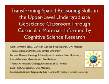
Transforming Spatial Reasoning Skills inthe Upper-Level UndergraduateGeoscience Classroom ThroughCurricular Materials Informed byCognitive Science ResearchCarol Ormand, SERC, Carleton College & Geoscience, UW-MadisonThomas F. Shipley, Psychology, Temple UniversityBarbara Dutrow, Geology & Geophysics, Louisiana State UniversityLaurel Goodwin, Geoscience, UW-MadisonThomas A. Hickson, Geology, University of St. ThomasBasil Tikoff, Geoscience, UW-MadisonKinnari Atit, Kristin Gagnier, & Ilyse Resnick, Psychology, Temple University
Outline The problem Our solution Insights from cognitive science research Curricular implementation in upper-division geology courses Research questions and study design: evaluating our curricularmaterials Data Conclusions
The Problem“Spatial thinking is pervasive: it is vital across a wide range ofdomains of practical and scientific knowledge; yet it is underrecognized, undervalued, underappreciated, and therefore underinstructed.”Learning to Think Spatially, National Research Council, 2006“Spatial thinking – you can’t leave home without it.”The People’s Guide to Spatial Thinking, Sinton et al., 2013
The ProblemDistribution of Vandenberg & Kuse (1978) Mental Rotation pre-test scores for students inMineralogy, Structural Geology, and Sedimentology/Stratigraphy courses.
The ProblemScores on the Geologic Block Cross-sectioning Test vs. the Vandenberg & Kuse Mental Rotation Test (N 142).Although R 0.40, indicating a statistically significant correlation of these two skills, some students who excel atvisualizing a cross-section through a geologic block diagram have weak mental rotation skills.
Context Spatial visualization is a key skill for understanding and solvingmany geological problems Undergraduate geoscience students, including students inupper-level courses, bring a wide range of spatial skills to theclassroom Spatial skills are malleable (e.g., Sorby, 2009; Uttal et al., 2013) SILC (the Spatial Intelligence &Learning Center) studies thedevelopment of spatial thinkingskills and is particularlyinterested in spatial thinking inthe geosciences
Our solution: curricular materials informed bycognitive science research (the Spatial Workbook) Premise: Use strategies/tools from cognitive science research(e.g. Gentner and Markman, 1994; Goldin-Meadow, 2011) todevelop curricular materials that will boost students’ spatial skills 3D sketching and predictionGestureAnalogical reasoningProgressive alignment** Progressive alignment is the process of moving from the comparison ofvery similar to less similar objects, in order to identify salient differences.
Our Research Questions Can curricular materials informed by cognitive science researchboost students’ domain-general spatial thinking skills (their abilityto perform abstract spatial tasks)? Can these materials booststudents’ domain-specificspatial thinking skills (theirability to reason aboutspatially complex geologicalconcepts and problems)? Will these gains be greaterthan the improvement wetypically see over the courseof a semester?
Our solution: curricular materials informed bycognitive science research (the Spatial Workbook)Strategies/tools from cognitivescience research:Upper-level geosciencecourses:3D sketching and predictionGestureAnalogical reasoningProgressive alignmentMineralogyStructural GeologySedimentology &StratigraphyX
Our solution: curricular materials informed bycognitive science research (the Spatial Workbook)
Examples from the Workbook 3D cleavage patterns around folds: Sketch bedding/cleavage intersections, in outcrop view What would you look for, in the field, to distinguish transectingcleavage from axial planar or fanning cleavage?Images from the course textbook, StructuralGeology, Haakon Fossen (2010), University Press
Examples from the Workbook
Examples from the Workbook Misconception: Strain is (always) 2-dimensional Exercise: Calculate thecross-sectional area ofdeformed layers atdifferent stages ofdeformation. Is the areaconstant? Why or whynot? Students compare 2 setsof images: 2D and 3DstrainImage from Dixon, John M. and Liu, Shumin, Centrifugemodeling of the propagation of thrust faults, in ThrustTectonics (Ken R. McClay, ed.), 1992
Examples from the Workbook
Examples from the Workbook
Examples from the Workbook
Examples from the Workbook
Examples from the Workbook
Outline The problem Our solution Insights from cognitive science research Curricular implementation in upper-division geology courses Research questions and study design: evaluating our curricularmaterials Data Conclusions
Our Research Questions Can curricular materials informed by cognitive science researchboost students’ domain-general spatial thinking skills (their abilityto perform abstract spatial tasks)? Can these materials booststudents’ domain-specificspatial thinking skills (theirability to reason aboutspatially complex geologicalconcepts and problems)? Will these gains be greaterthan the improvement wetypically see over the courseof a semester?
Classroom Study DesignParticipants: Structural Geology at UW-Madison (N 31; N 34; N 32) Mineralogy at Louisiana State University (N 15; N 17; N 26) Sedimentology & Stratigraphy at the University of St. Thomas (N 18; N 8)All courses, all years: Administer pre- and post-tests of spatial thinking skills, focusing on mentalrotation and penetrative thinking (visualizing interiors)Document instructional strategies, materialsCollect data from student performance on embedded assessments (e.g., examquestions that require discipline-based spatial thinking)Collect student data from registrars (SAT/ACT scores, GPAs, course grade)Timeline: 2011-2012: Baseline year; no changes in instruction 2012-2013: Pilot implementation; draft exercises in Mineralogy and Structure 2013-2014: Full scale implementation in all 3 courses
Spatial Thinking Testsa. Mental rotation(MRT-A)b. Mental slicing:geometric solids(Planes ofReference)c. Slicing: mineralsd. Slicing: geologicblock diagramse. Water level
Baseline data, Structural Geology,UW-MadisonN 31
Spatial test scores, Structural Geology,baseline vs. implementation
Spatial test scores, Mineralogy,baseline vs. implementation
Spatial test scores, Sed/Strat,baseline vs. implementation
Our Research Questions Can curricular materials informed by cognitive science researchboost students’ domain-general spatial thinking skills (their abilityto perform abstract spatial tasks)? Can these materials booststudents’ domain-specificspatial thinking skills (theirability to reason aboutspatially complex geologicalconcepts and problems)? Will these gains be greaterthan the improvement wetypically see over the courseof a semester?
Embedded assessments, StructuralGeology, UW-MadisonWhat is it we want students to be able to DO after this course?
Embedded assessments, StructuralGeology, UW-MadisonWhat is it we want students to be able to DO after this course?
Embedded assessments, StructuralGeology, UW-MadisonWhat is it we want students to be able to DO after this course?
Embedded assessments, StructuralGeology, UW-MadisonWhat is it we want students to be able to DO after this course?
Embedded assessment scores, UW-MadisonStructure, baseline vs. implementationEmbedded Assessments10.9***0.80.7**0.60.50.40.30.20.10year 1 year 3 year 1 year 3 year 1 year 3 year 1 year 3 year 1 year 3 year 1 year 3 year 1 year 3 year 1 year 3 year 1 year 3 year 1 year 3 year 1 year 312345678910Final Grade
Conclusions We can boost students’ domain-specific spatial thinking skills,beyond the gains they would “normally” get from takinggeoscience courses. While students’ domain-general spatialskills also show improvement, these gains are statistically thesame as the gains we see in our baseline data. Teaching spatial thinking in the context of discipline-basedexercises has the potential to transform undergraduate STEMeducation by removing one significant barrier to success.
l
ReferencesGentner, D., and Markman, A.B. (1994). Structural alignment in comparison: No differencewithout similarity. Psychological Science, v. 5, pp. 152-158.Goldin-Meadow, S. (2011). Learning through gesture. WIREs (Wiley InterdisciplinaryReviews): Cognitive Science, v. 2, n. 6, pp. 595-607.National Research Council (2006). Learning to think spatially—GIS as a support system inthe K-12 curriculum. Washington DC: National Academies Press. 313 pp.Sinton, D.S., Bednarz, S., Gersmehl, P., Kolvoord, R. and Uttal, D. (2013). The People’s Guideto Spatial Thinking: National Council for Geographic Education. 81 pp.Sorby, S. (2009). Educational Research in Developing 3-D Spatial Skills for EngineeringStudents: International Journal of Science Education, v. 31, n. 3, pp. 459-480.Uttal, D.H., Meadow, N.G., Tipton, E., Hand, L.L., Warren, C., and Newcombe, N.S. 2013. Themalleability of spatial skills: A meta-analysis of training studies. Psychological Bulletin,139:352-402.Vandenberg, S.G., and Kuse, A.R. (1978). Mental rotations, a group test of three-dimensionalspatial visualization. Perceptual and Motor Skills, 47, 599 – 604.
Learning to Think Spatially, National Research Council, 2006 “Spatial thinking – you can’t leave home without it.” The People’s Guide to Spatial Thinking, Sinton et al., 2013 . The Problem Distribution of Vandenberg & Ku