Transcription
ERDC TR-19-26ERDC 6.2 Geospatial Research and Engineering (GRE) ARTEMIS STO-RArmy Terrestrial Environmental Modelingand Intelligence System, ARTEMISEngineer Research andDevelopment CenterJohn Eylander, Sally Shoop, Elias Deeb, Carrie Vuyovich,Steven Peckham, Sandra LeGrand, Robyn Barbato, TheodoreLetcher, D. Keith Wilson, Andmorgan Fisher, John Nedza,Dhiren Khona, Michael Paquette, Jerry Bieszczad, andChristian BordenApproved for public release; distribution is unlimited.December 2019
The U.S. Army Engineer Research and Development Center (ERDC) solvesthe nation’s toughest engineering and environmental challenges. ERDC developsinnovative solutions in civil and military engineering, geospatial sciences, waterresources, and environmental sciences for the Army, the Department of Defense,civilian agencies, and our nation’s public good. Find out more at www.erdc.usace.army.mil.To search for other technical reports published by ERDC, visit the ERDC online libraryat http://acwc.sdp.sirsi.net/client/default.
ERDC 6.2 Geospatial Research andEngineering (GRE) ARTEMIS STO-RERDC TR-19-26December 2019Army Terrestrial Environmental Modeling andIntelligence System, ARTEMISJohn Eylander, Sally Shoop, Elias Deeb, Carrie Vuyovich, Steven Peckham, SandraLeGrand, Robyn Barbato, Theodore Letcher, and D. Keith WilsonU.S. Army Engineer Research and Development Center (ERDC)Cold Regions Research and Engineering Laboratory (CRREL)72 Lyme RoadHanover, NH 03755-1290Andmorgan Fisher, John Nedza, Dhiren Khona, and Michael PaquetteU.S. Army Engineer Research and Development Center (ERDC)Geospatial Research Laboratory (GRL)7701 Telegraph RoadAlexandria, VA 22315-3864Jerry BieszczadCreare, LLC16 Great Hollow RoadHanover, NH 03755-3116Christian BordenAtmospheric and Environmental Research, Inc.131 Hartwell AvenueLexington, MA 02421-3105Final ReportApproved for public release; distribution is unlimited.Prepared forUnderAssistant Secretary of the Army for Acquisitions, Logistics, and Technology103 Army PentagonWashington, DC 20314-1000ERDC 6.2 Geospatial Research and Engineering (GRE) Army TerrestrialEnvironmental Modeling and Intelligence System Science TechnologyObjective–Research (ARTEMIS STO-R) under Work Item ARTEMIS CRREL T42053HJ0, Funding Account Number U4357509
ERDC TR-19-26AbstractThe Army Terrestrial Modeling and Intelligence System (ARTEMIS) research program focused on developing innovative methods of fusingweather data from authoritative sources with geospatial content and services to fill a number of identified Army capability gaps. The tools developed within the ARTEMIS research program can support operations anywhere in the world, supporting Army Global Land Operation’s needs. Weovercame technology challenges that limited the use of gridded weatherproducts and digital terrain products with Army tactical decision aids,providing relevancy to the impacts of weather and terrain on military operations beyond the current methods of delivering weather impacts on thebattlefield via PowerPoint briefings. The project benefited from the recentavailability of higher-resolution global soil texture, digital elevation models, and land use and land cover datasets provided by the National Geospatial-Intelligence Agency. Teams working on the ARTEMIS research program developed tools and capabilities that integrated weather digital products into the Army Geospatial Enterprise–compliant systems to deliverfused all-weather and all-season military decision aids (e.g., maneuver,austere entry, sensor performance, and other typical terrain analysis tasks)in a method that supports risk-based assessments.DISCLAIMER: The contents of this report are not to be used for advertising, publication, or promotional purposes. Citation of trade names does not constitute an official endorsement or approval of the use of such commercial products.All product names and trademarks cited are the property of their respective owners. The findings of this report are not tobe construed as an official Department of the Army position unless so designated by other authorized documents.DESTROY THIS REPORT WHEN NO LONGER NEEDED. DO NOT RETURN IT TO THE ORIGINATOR.ii
ERDC TR-19-26iiiContentsAbstract . iiFigures and Tables .ivPreface .viAcronyms and Abbreviations .viiExecutive Summary .xWhat was the problem? . xWhat barriers did we overcome to solve this problem? . xiHow did we overcome those barriers? . xiiWhat are the capabilities we developed? . xiiiQuantitative metrics . xivTransitions . xvTeams and laboratories . xvi1Introduction . 11.1 Background . 11.2 Objective . 21.3 Approach . 32Technical Description. 72.1Models . 82.1.1Description of approach . 82.1.2Terrain analysis numerical modeling testbed . 82.1.3Snow remote-sensing and numerical-modeling research . 122.2 Terrain phenomenology research . 182.2.1Dust research . 182.2.2Biosentinels research . 212.3 Weather-informed mobility . 232.4 Remote assessment for ingress/egress locations . 262.5 Sensor performance . 292.5.1Improved acoustics in EASEE . 292.5.2EASEE Web Services design . 342.5.3Integration of a four-dimensional weather system support to EASEE . 352.6 Validation of tools and quantitative metrics. 383Summary of ARTEMIS Major Accomplishments .423.1 Technical Transitions . 433.2 Using ARTEMIS tools for direct Army support. 444Conclusion .45References . 47Report Documentation Page
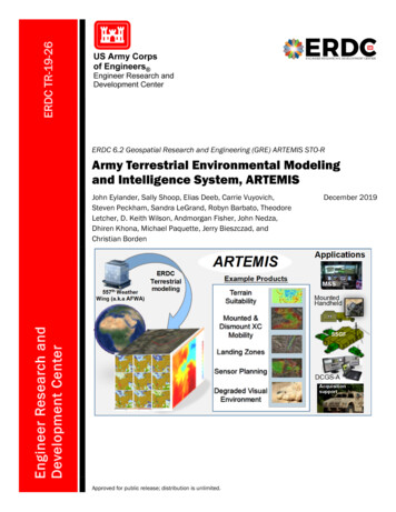
ERDC TR-19-26ivFigures and TablesFigures1High-level operational concept graphic of the ARTEMIS project. The project wasdesigned to pull weather data in from the U.S. Air Force 557th Weather Wing andthen to compute higher-resolution weather and terrain products that would beused in military decision aids (middle column of box). The military decision-aidproducts would then be integrated into geographical information systems (rightcolumn of box). Example products are listed on the far right side . 52Diagram of the LIS software framework, provided by Sujay Kumar at NASA (pers.comm.). The software is organized with a core set of software managementmodules and drivers (LIS Core) and abstractions that include the various landsurface models, data assimilation methods, meteorological input options, etc.The abstractions are controlled through the LIS configuration file a user modifiesprior to executing the model .103Volumetric soil moisture (left image) and relative soil moisture (right image) fromUSAF’s 557th Weather Wing, produced by the Land Information System model.Volumetric soil moisture is the measure of water quantity per unit volume of soiland contains the units of m3/m3. Relative soil moisture is a unitless measure ofthe relative wetness of the soil related to the soil’s water-holding capacity .104CRREL snow water equivalent charting technology as generated by the USAF’s14th Weather Squadron. The red line is the current year’s snow water equivalent(SWE), the purple line is the prior year’s SWE, and the green dashed linerepresents the average SWE for the domain. The light blue region on the graphrepresents the standard deviation range of the climatological period, and thedark blue lines represent the maximum and minimum values observed for thewatershed .135Snow-covered (blue shading) area map produced from VIIRS satellite data usingsnow detection algorithms developed by CRREL and run operationally by the U.S.Air Force 557th Weather Wing. The red lines are watershed boundaries forAfghanistan. CRREL improved the snow cover mapping algorithms andtransitioned the technology to the USAF within the ARTEMIS project.146Snowfall, snowmelt, and snow sublimation simulations from the WRF (leftcolumn) and LIS (right column) models. The sublimation results from LIS arehigher than from WRF . 177DRTSPORE model output showing predictions of soil microbial activity from highresolution digital elevation models and weather forecasts over a 10-day periodover Kandahar .238GeoWATCH overview. GeoWATCH predicts global weather-impacted terrainconditions, including soil moisture, soil strength, and vehicle speed, at tacticalscale resolution. It features open-standard data formats and transmissionprotocols, enabling access from any networked device. 249Diagram outlining the components of the GRAIL toolbox development, includingthe user input and field validation studies (after Shoop and Wieder 2018) . 2710Potential C-130 assault landing zone sites at Fort Hunter Liggett, California,located by the GRAIL Tools from (Shoop and Wieder 2018). The key in the upperleft indicates the orientation (compass degrees) of the runway.28
ERDC TR-19-26v11Drop zones for 50 and 150 foot radius locations in Fort Hunter Liggett, California(Shoop et al. 2018). The color key in the upper right of both images labels thelocations suitable for drop zones (yellow colors) versus unsuitable zones (gray) .2812Web-based user interface for the EASEE system. The graphical illustration on theright side of the image is acoustic propagation of an Army helicopter flying alonga path through a valley near Fort Huachuca, Arizona, that ends at the base. Theuser interacts with menus along the top of the display, including weatherinformation, asset type, sensor model, and other information about the sensorsand environment. The left side contains asset information about the height ofthe flight path. The user can use the slider bar in the lower left to look at theresults over time as well as overlay some weather information .3513. Diagram of the EASEE Web Services software describing the flow of data andmethods used to feed data to compute EASEE products in a web servicesplatform. 3714. Two illustrations of using EASEE running in a web services environment (showing overFort Huachuca, Arizona, and the surrounding area) by using the GeospatialWeather Services capability to support weather impacts. The weather scenario isfor 11–13 November 2011 and includes temperature, winds, humidity, cloudcover information (including base height, coverage), and Army IntegratedWeather Effects Decision Aid rules. During the period, a frontal passage causeda change in weather that influenced acoustic propagation. Both model runs arefor a helicopter flight path. The difference in weather conditions causes adifference in acoustic propagation between the two time periods. The image onthe left includes weather conditions from 14-November-2011 at 1400 UTC whilethe image on the right is weather conditions from 13-November-2011 at 2200UTC .3815Comparison of GeoWATCH soil moisture products with TDR data from theTarrawarra watershed in Australia. For each of the six dates shown, ranging fromdry to saturated soil conditions, the image on the left is the initial USAF 25 kmLIS product. The middle image is the downscaled soil moisture from GeoWATCH,and the image on the right is the TDR measured soil moisture. (Audette et al.2017).4016GeoWATCH output for the Nevada National Security Site. The region of darkerblue colors extending from the upper right towards the middle of the imageexists in a coarse-grained wash. Soil-moisture measurements for this regionwere much lower than the model-estimated values . 41Tables1Metrics Technical Readiness Levels (TRLs) and pre- and post-ARTEMIS metricsachieved during the 4-year span of the project .39
ERDC TR-19-26PrefaceThis study was conducted for the Assistant Secretary of the Army for Acquisition, Logistics, and Technology under the U.S. Army Engineer Research andDevelopment Center (ERDC) 6.2 Geospatial Research and Engineering (GRE)Applied Research Program’s Army Terrestrial-Environmental Modeling andIntelligence System Science Technology Objective–Research (ARTEMIS STOR), Work Item ARTEMIS CRREL T42 053HJ0, Funding Account NumberU4357509, “ARTEMIS Army Terrestrial Environmental Mode.”The work was performed by the Force Projection and Sustainment Branch(CEERD-RRH), the Terrestrial and Cryospheric Sciences Branch (CEERDRRG), and the Signature Physics Branch (CEERD-RRD) of the Researchand Engineering Division (CEERD-RR) and the Lidar and WetlandsGroup and the Terrain and Ice Engineering Group of the Remote Sensing/GIS Center of Expertise (CEERD-RS), ERDC Cold Regions Researchand Engineering Laboratory (CRREL), and the Data Signature and Analysis Branch (CEERD-TRS), the Data Representation Branch (CEERDTRR), and the Information Generation and Management Branch (CEERDTRG) of the Topography, Imagery, and Geospatial Research Division(CEERD-TR), ERDC Geospatial Research Laboratory (GRL). At the timeof publication, Mr. Justin Putnam was Acting Chief, CEERD-RRH; Dr.John Weatherly was Chief, CEERD-RRG; Dr. Andrew Niccolai was Chief,CEERD-RRD; Mr. J. D. Horne was Chief, CEERD-RR; Dr. Elias Deeb waslead for the Lidar and Wetlands Group; Mr. Stephen Newnan was lead forthe Terrain and Ice Engineering Group; Mr. David Finnegan was Chief,CEERD-RS; Ms. Jennifer Smith was Chief, CEERD-TRS; Mr. Vineet Guptawas Chief, CEERD-TRR; Mr. Jeffrey Murphy was Chief, CEERD-TRG; andMs. Martha Kiene was Chief, CEERD-TR. The Deputy Director of ERDCCRREL was Mr. David B. Ringelberg, and the Director was Dr. Joseph L.Corriveau. The Deputy Director of GRL was Ms. Valerie Carney, and theDirector was Mr. Gary Blohm.We would like to thank the research staff at the Jornada ExperimentRange, specifically Dr. Nicholas Webb and Mr. Brad Cooper, for site access. We would also like to thank Ms. Ashley Mossell, CRREL, for soilsanalysis support.COL Teresa A. Schlosser was the Commander of ERDC, and Dr. David W.Pittman was the Director.vi
ERDC TR-19-26viiAcronyms and Abbreviations3-DThree DimensionalAFWAAir Force Weather AgencyARTEMISArmy Terrestrial Environmental Modeling and Intelligence SystemCFSClimate Forecast SystemCFSRClimate Forecast System ReanalysisCRRELCold Regions Research and Engineering LaboratoryDMRT-MLDense Media Radiative Transfer for Multi LayersDoDDepartment of DefenseDRTSPOREDynamic Representation of Terrestrial Soil Predictions ofOrganisms’ Response to the EnvironmentDSRCDistributed Supercomputing Resource CenterDUST-CLOUDDynamic Undisturbed Soils Testbed to Characterize Local Originsand Uncertainties of DustEASEEEnvironmental Awareness for Sensor and Emitter EmploymentEDCEnvironmental Data CubeEHFExtremely High FrequencyERDCU.S. Army Engineer Research and Development CenterEWSEASEE Web ServicesFYFiscal YearGALWEMGlobal Air-Land Weather Exploitation ModelGEARGeocentric Environment for Analysis and ReasoningGeoWATCHGeospatial Weather Affected Terrain Conditions and HazardsGISGeographical Information System
ERDC TR-19-26viiiGPUGraphics Processing UnitGRAILGeospatial Remote Assessment for Ingress LocationsGREGeospatial Research and EngineeringGRLGeospatial Research LaboratoryGWXGeospatial Weather ServicesHPCHigh Performance ComputingITLInformation Technology LaboratoryKMLKeyhole Markup LanguageKNEEKNEE is not EASEE in its EntiretyKNLKnights LandingLISLand Information SystemMODISModerate Resolution Imaging SpectroradiometerNASANational Aeronautics and Space AdministrationNATONorth Atlantic Treaty OrganizationNCARNati
1 High-level operational concept graphic of the ARTEMIS project. The project was designed to pull weather data in from the U.S. Air Force 557th Weather Wing and then to compute higher-resolution weather and terrain products that would be used in military decision aids (middle column of box). The military decision -aid