Transcription
STANDARD LEGEND1995Date of issue: October 1995The copyright of this document is vested in Shell International Exploration and Production B.V., The Hague, the Netherlands. All rights reserved.This document may be reproduced, stored in any retrieval system or transmitted in any form or by any means without the prior written consent of the copyrightowner, except for the purpose of commercial exploitation.SHELL INTERNATIONAL EXPLORATION AND PRODUCTION B.V., THE HAGUEFurther copies can be obtained from SIEP, Document Centre if approved by the custodian of this document.
INTRODUCTIONThe Shell Exploration & Production Standard Legend 1995 is the Shell standard for symbols, abbreviations,display formats and terminology applied in hydrocarbon exploration and petroleum engineering. Thebeginnings of the document can be traced back for some 60 years and consequently its contents reflectboth long established and recently introduced practices, as well as international conventions. Some contentsof this document are also to be found in the "AAPG Sample Examination Manual" (Swanson, 1981).The aim of this document is to promote a standard for communication within Shell's worldwide operatingorganisation, and within industry and academia. The document is also available on a CD-ROM (inserted inthe back cover). However, for copyright reasons the CD-ROM does not include the fold-out figures.Appendix 7 contains a short guide on its use. Symbols which are individually numbered can be copied fromthe CD-ROM into other applications.This Standard Legend 1995 is a revision of the 1976 edition. Definitions have been largely omitted; forthese, the user is referred to the "Glossary of Geology" (Bates & Jackson, 1987) and the "GeologicalNomenclature" (Visser, 1980).The contents of the various chapters are:-Chapter 1.0 General contains sections on Rules for Abbreviations, Report Presentation, and StandardDocuments, such as Mud Log, Electrical Log Displays, Well Completion (Composite) Log, Well Proposal,Well Résumé, Play Maps and Cross-sections.-Chapter 2.0 Wells and Hydrocarbons comprises sections such as Well Symbols on Maps and Sections,Well Bore Symbols, Hydrocarbon Shows, Hydrocarbon Fields and Surface Hydrocarbon Seeps.-Chapter 3.0 Topography is based mainly on international conventions.-Chapter 4.0 Geology contains the key sections Lithology, Rock Description, and Stratigraphy includingSequence Stratigraphy. Two stratigraphical charts, 'Geological Data Tables Cenozoic - Mesozoic andPalaeozoic', are enclosed.The section Depositional Environments includes abbreviations and colour codes for palaeobathymetry,and a terminology for detailed facies analysis.The section Palaeogeographical Maps proposes two standards, one for basin scale maps and one forcontinental/global scale maps.The section Structural Geology includes a subsection on Trap Description.-Chapter 5.0 Geochemistry deals with source rocks, their evaluation, maturity and burial.-Chapter 6.0 Geophysics is a major chapter including Gravity and Magnetics. The section Seismic alsoencompasses entries on Seismic Interpretation including Seismic Attribute Maps and SeismicStratigraphy, and Well Shoot and Vertical Seismic Profile.-The Alphabetical Index and the Alphabetical Listing of Abbreviations are to be found at the end of thisdocument, together with a number of Appendices, including one on the RGB/CMYK values of thevarious colours to be used.The 1995 edition is the result of a multidisciplinary effort by a group of geologists, stratigraphers,geophysicists, geochemists, petroleum engineers and operations engineers from SIEP, Research andOperating Companies striving for consensus without dogma.The Project Steering Group, compiler and contributors hope that this new edition will be as widely used asits 1976 predecessor.The Shell Standard Legend 1995 is classed as a non-confidential document.The Hague, September 1995.
The Project Steering Group for the Standard Legend 1995 was:R. BuchananP.A.B. MarkeP.J.D. van DitzhuijzenB.M. ReinhardtJ.R. FreakeL.L. WakefieldD.L. LoftusG.J. WilliamsThe main contributors were:J.W. BurggraaffH.P. MohrT.J. FaulknerJ.C. MondtP.S. FeatherstoneM.A. NaylorG.E.A. FoubertE.J.M. OverboomE.A. HaanY.M. QuillienMs B.K. HoweM.W. ShusterP.J.F. JeansG.S. SteffensG.W.M. LijmbachM. WannierThe final draft was reviewed by the Steering Group, Exploration/Production staff of Shell Research B.V.,and the following OpCos:Brunei Shell Petroleum Co Sdn BhdShell UK Exploration & Production LtdNederlandse Aardolie Maatschappij B.V.The Shell Petroleum Development Co of Nigeria LtdPetroleum Development Oman LLCSabah Shell Petroleum Co Ltd/Sarawak Shell BhdSupport was also received from Draughting, Desk-Top Publishing, Information Technology and Editing staff:E.P.J. ClavauxJ.H. LekC. van den EndeE.C.M. SchmidtMs J.J. HillebrandtJ.J. WachtersR.M. HolsnijdersA.N.R. WrightAcknowledgements for granting copyrights are due to Professor W.B. Harland (Cambridge),Dr B.U. Haq (Washington), and Nederlandse Aardolie Maatschappij B.V.Compiler and Editor: W.G. WittSponsor: D.L. Loftus
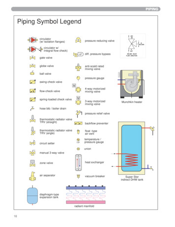
CONTENTS LIST1.0 GENERAL1.1 Rules for Abbreviations1.2 Report Presentation1.3 Standard Documents1.3.1 Mud Log1.3.2 Electrical Log Displays1.3.3 Well Completion (Composite) Log1.3.4 Well Proposal1.3.5 Well Résumé1.3.6 Play Maps and Cross-sections2.0 WELLS AND HYDROCARBONS2.1 Well Symbols on Maps and Sections2.1.1 Surface Location Symbols2.1.2 Subsurface Location Symbols2.1.2.1 Technical Status2.1.2.2 Hydrocarbon Status2.1.2.3 Production Status2.1.2.4 Injection Status2.1.2.5 Completion Status2.1.2.6 Geological/Structural Information2.1.2.7 Type of Well2.1.3 Deviated Holes2.1.4 Horizontal Holes2.1.5 Multilateral Holes2.1.6 Multilateral Horizontal Holes2.2 Well Bore Symbols2.2.1 General Drilling Data2.2.2 Formation Lithological Sampling and Dip Data2.2.3 Casing and Cementations2.2.4 Completion Methods2.2.5 Formation Treatment2.2.6 Production Test Results and Data2.2.7 Lithology2.2.8 Hydrocarbons, Gases and Waters2.2.8.1 Gas2.2.8.2 Oil2.2.8.3 Solid Hydrocarbons2.2.8.4 Formation Waters2.2.8.5 Vintage Hydrocarbon Show Symbols2.3 Hydrocarbon Show Reporting2.4 Hydrocarbon Fields and Prospects on Maps and Sections, Colour Coding2.5 Surface Hydrocarbon and Water Seeps (Shows) on Maps2.5.1 Gas2.5.2 Oil2.5.3 Solid Hydrocarbons2.5.4 Surface Water Springs, Seepages
2.5.5 Mud Volcanoes3.0 TOPOGRAPHY3.1 Survey Datum3.2 Survey Reference Points3.2.1 Horizontal Control Points3.2.2 Vertical Control Points3.2.3 Other Position Markers3.2.4 Survey Control Lines3.3 Boundaries3.3.1 Political Boundaries3.3.2 Concession Boundaries3.3.3 Area Limits Offshore3.3.4 Area Limits on Land3.4 Artificial Features3.4.1 Linear Features3.4.2 Point Features3.4.3 Area Features3.4.4 Offshore Structures and Markers3.4.5 Informative Symbols3.5 Natural Features3.5.1 Linear Features3.5.2 Point Features3.5.3 Area Features3.5.4 Environmental Maps3.6 Elevation Contours3.7 Bathymetric Contours4.0 GEOLOGY4.1 Photogeology4.1.1 Morphological Features4.1.2 Geological Features4.2 Lithology4.2.1 Order of Description4.2.2 Siliciclastics4.2.2.1 Framework Composition4.2.2.2 Siliciclastic Lithotypes4.2.3 Carbonates4.2.3.1 Carbonate Classification4.2.3.2 Carbonate Lithotypes4.2.4 Mixed Siliciclastics-Carbonates4.2.5 Evaporites4.2.6 Organic-rich Rocks4.2.7 Miscellaneous Sediments4.2.8 Igneous Rocks4.2.8.1 Intrusive (Plutonic) Rocks4.2.8.2 Dykes, Sills
4.2.8.3 Extrusive (Volcanic) Rocks4.2.8.4 Ophiolites4.2.9 Metamorphic Rocks4.2.10 Lithological Colour Symbols4.3 Rock Description4.3.1 Texture and Composition4.3.1.1 Grain Size4.3.1.2 Sorting4.3.1.3 Roundness4.3.1.4 Sphericity4.3.1.5 Compaction4.3.1.6 Non-skeletal Particles4.3.1.7 Non-skeletal Particle Texture and Size4.3.1.8 Pellets and Coated Grains4.3.1.9 Skeletal Particles4.3.1.10 Compositional Siliciclastics Classification4.3.2 Porosity and Permeability4.3.2.1 Fabric Selective Porosity4.3.2.2 Non-fabric Selective Porosity4.3.2.3 Relative Timing of Porosity Generation4.3.2.4 Porosity (qualitative by visual estimate)4.3.2.5 Permeability (qualitative)4.3.2.6 Archie Classification4.3.2.7 Archie Porosity Types4.3.3 Colour Description4.3.3.1 Colours4.3.3.2 Modifying Adjectives4.3.4 Accessory Minerals4.3.5 Fossils4.3.5.14.3.5.24.3.5.34.3.5.4Fossils, GeneralFossils, SpecificIchnofossilsOrganogenic Structures4.3.6 Stratification and Sedimentary Structures4.3.6.1 Bed Thickness4.3.6.2 Bedding Appearance4.3.6.3 Character of Base of Bed4.3.6.4 Miscellaneous Terms4.3.6.5 Large Sedimentary Features4.3.6.6 Cross-bedding4.3.6.7 Ripplemarks on Bedding Planes4.3.6.8 Horizontal Lamination4.3.6.9 Wavy/Irregular/Lenticular Stratification4.3.6.10 Graded Beds4.3.6.11 Lineations on Bedding Planes4.3.6.12 Soft Sediment Deformation4.3.6.13 Syndepositional Marks and Miscellaneous Structures4.3.7 Post-depositional Features4.3.7.1 Miscellaneous Post-depositional Features4.3.7.2 Diagenetic Structures4.3.7.3 Nodules/Concretions4.4 Stratigraphy4.4.1 Lithostratigraphy4.4.1.1 Lithostratigraphical Terminology4.4.1.2 Lithostratigraphical Gaps4.4.2 Biostratigraphy4.4.2.1 Zonal Terminology
4.4.2.2 Zones/Zonation4.4.2.3 Quantity Symbols for Distribution Charts4.4.3 Chronostratigraphy and Geochronology4.4.4 Sequence Stratigraphy4.4.5 Stratigraphical Boundaries on Maps4.4.5.1 General4.4.5.2 Layer Maps4.4.6 Gaps and Unknown Formations4.4.6.1 Gaps on Columnar Sections and Stratigraphical Tables4.4.6.2 Gaps on Layer Maps4.5 Depositional Environments4.5.1 Biostratigraphical Charts4.5.1.1 Abbreviations4.5.1.2 Colour Coding4.5.2 Maps and Sections, Colour Coding4.5.3 Facies Terminology4.5.3.1 Clastic Facies4.5.3.2 Carbonate Facies4.6 Palaeogeographical Maps4.6.1 Basin Scale Maps4.6.2 Continental/Global Scale Maps4.7 Structural Geology4.7.1 Faults, General Aspects4.7.2 Faults on Surface Geological and Horizon Maps4.7.2.1 Symbols for Fault Types4.7.2.2 Re-activated Faults4.7.2.3 Fault Reliability and Heave4.7.2.4 Horizon Contours4.7.2.5 Fault-Contour Relationships4.7.3 Folds and Flexures4.7.4 Dip and Strike Symbols on Surface Geological Maps4.7.4.1 Bedding4.7.4.2 Miscellaneous Structural Features4.7.5 Structural Cross-sections4.7.6 Trap Descriptions4.7.6.1 Basic Trap Elements4.7.6.2 Trap Styles in Different Tectonic Settings4.7.7 Closures on Play, Lead and Prospect Maps4.7.7.1 Structural Closure4.7.7.2 Non-structural Closure5.0 GEOCHEMISTRY5.1 Source Rocks5.1.1 Source Rock Type5.1.2 Source Rock Evaluation5.1.2.1 Interpretation of Rock Eval Data5.1.2.2 Van Krevelen Classification of Kerogen Types5.2 Source Rock Maturity and Hydrocarbon Generation5.2.1 Maturity Zones5.2.2 Burial Graph5.2.3 Maturity vs. Depth Graph
6.0 GEOPHYSICS6.1 Seismic6.1.1 Seismic Acquisition and Location Maps6.1.2 Seismic Processing and Display6.1.2.1 Side Label6.1.2.2 Data along Section6.1.2.3 Polarity Conventions6.1.3 Seismic Interpretation6.1.3.1 Interpreted Seismic Sections6.1.3.2 Seismic Attribute Maps6.1.3.3 Seismic Stratigraphy6.1.3.4 Seismic Contour Maps6.1.4 Well Shoot and Vertical Seismic Profile6.2 Gravity6.3 MagneticsReferencesAlphabetical IndexAlphabetical Listing of AbbreviationsAppendices1. Chronostratigraphical Units, Ordered by Age2. Chronostratigraphical Units, Alphabetical3. Chronostratigraphical Units, Abbreviations, Alphabetical4. Colours, Names and RGB/CMYK Values5. Definitions of Depth Measurements6. Thickness Definitions7. The CD-ROM Version
1.0 GENERAL1.1 Rules for AbbreviationsAbbreviations are used by the Royal Dutch/Shell Group of Companies on (geological) maps and sections,on well logs, in fieldbooks, etc. In all these cases brevity is essential to record the information in a limitedspace.When using abbreviations adherence to the following rules is essential:1. Initial letters of abbreviationsThe same abbreviation is used for a noun and thecorresponding adjective. However, nouns begin with acapital letter, adjectives and adverbs with a small letter.2. Singular and pluralNo distinction is made between the abbreviation of thesingular and plural of a noun.3. Full stop (.)Full stops are not used after abbreviations.4. Comma (,)Commas are used to separate groups of abbreviations.Example:sandstone, grey, hard, coarse grained,ferruginous— Sst, gy, hd, crs, fe5. Semi-colon (;)Semi-colons are used to separate various types of rockswhich are intercalated.Example:shale, brown, soft with sand layers, finegrained, glauconitic— Sh, brn, soft; S Lyr, f, glc6. Dash (-)Dashes are used to indicate the range of a characteristic.Example:fine to medium, grey to dark grey— f - m, gy - dk gy7. Plus ( )Used as an abbreviation for “and”.Example:shale and sand— Sh S8. Plus - minus ( )Used as the abbreviation for “more or less” or“approximate”.Example:shale with approximately 25 % sand— Sh 25 % S9. UnderliningUsed to add emphasis to an abbreviation.Examples:very sandy — swell bedded — bdvery well sorted — srt10. BracketsUsed to indicate diminutive adjectives or adverbs andindefinite colours.Examples:slightly sandy — (s)bluish grey — (bl) gypoorly sorted — (srt)
1.2 Report PresentationPreparation of ReportsGeneral RemarksA certain degree of uniformity in the presentation of reports is desirable. In order to facilitate filing, therecommended format should be A4 (210 x 297 mm 8.25 x 11.75 inches; size used in USA and Canada 8x 10.5 inches). For the cover (and the title page) of the report, adhere to the local company rules withrespect to the use of colours, logo, copyright and confidentiality clauses, etc.The following suggestions are offered regarding the layout:TextA report should have a title page and a contents page, following the general lines of specimens as shownon the Figures in this chapter.A ‘summary’ or ‘abstract’ should be given at the beginning of the report. Along with this, also give the‘keywords’ as a quick reference to the report and its various subjects.The pages of the report should be numbered with arabic numerals, while the contents page(s) can benumb
- Chapter 4.0 Geology contains the key sections Lithology, Rock Description, and Stratigraphy including Sequence Stratigraphy. Two stratigraphical charts, 'Geological Data Tables Cenozoic - Mesozoic and Palaeozoic', are enclosed. The section Depositional Environments includes abbreviations and colour codes for palaeobathymetry,