Transcription
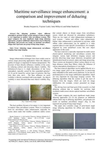
Maritime surveillance image enhancement: acomparison and improvement of dehazingtechniquesBranka Stojanović, Vojislav Lukić, Saša Milićević and Srđan Stanković dehazingproblem wheredifferentAbstract—Theatmospheric particles brings certain amount of noise to imagesis very important in outdoor video surveillance systems. Thispaper compares the most significant single image dehazingapproaches, proposes additional enhancement step in dehazingalgorithms, and presents test results on maritime surveillanceimages that represents one group of long-range images.Index Terms—dehazing; image enhancement, surveillanceimaging, long-range imaging.I. INTRODUCTIONImage enhancement techniques have been widely used invarious image processing applications where the subjectivequality of images is important for human interpretation. Thepresence of haze directly influences visibility of the scene,by reducing contrast and obscuring objects visibility. Thedefinition of a haze is “a slight obscuration of the loweratmosphere, typically caused by fine suspended particles”[1]. It can be caused by various types of particles, like fog,mist, dust, rain, snow The haze influence on scenevisibility is directly correlated with scene depth – far objectsvisibility is more obscured than near objects visibility (Fig.1).Fig. 1 Typical hazy imageThe haze problem, because of its nature, is very importantin outdoor video surveillance systems. There is a continuousneed for surveillance video enhancement, especially forscenes taken under bad weather conditions and/or scenesBranka Stojanović, is with Institute Vlatacom, Milutina Milankovića l:branka.stojanovic@vlatacom.com).Vojislav Lukić, is with Institute Vlatacom, Milutina Milankovića l:vojislav.lukic@vlatacom.com).Saša Milićević, is with Institute Vlatacom, Milutina Milankovića l:sasa@vlatacom.com).Prof. dr Srđan Stanković, is with Institute Vlatacom, MilutinaMilankovića 5, 11070 Belgrade, Serbia; (phone: 381-11-3771100, e-mail:srdjan.stankovic@vlatacom.com).that contain objects at distant ranges from surveillancesensor, which are obscured by atmosphere turbulences.There are two types of video enhancement techniques insuch systems – online and offline video enhancement.Online video enhancement is performed in real-time, whileoffline video enhancement can be applied to a videosegment taken in some specific circumstances, for example,triggered by some predefined events like new objectappearance in the scene.The haze removal is especially important for multi-sensorelectro-optical monitoring and surveillance systems thatintegrate various high definition imaging sensors andprovide ultra-long range target detection, recognition andidentification based on sensors, optics and image processing.These systems are designed to detect various objects at verylarge distances (more than 20km), where the influence ofvarious atmospheric disturbances is very high.The haze removal algorithms can be applied directly on arow image signal, prior to the compression, in processingunits embedded at the multi-sensor platforms. It can also beperformed prior to the image stabilization algorithms, whichare very important for long-range imaging systems. Thedehazing algorithms help the system to get the most offeatures from the images, which are used for imagestabilization (for example, corners presented on imagescene).The driving force and final goal of this research is to finddehazing solution that is suitable for real-time highresolution multi-sensor electro-optical maritime surveillancesystems.This paper compares the most significant single imagedehazing approaches [2] [3] [4], proposes an additionalenhancement step in dehazing algorithms, and presents testresults on maritime surveillance images 1 (Fig. 2), thatrepresent one group of long-range images.The paper also considers usage of prior-based singleimage dehazing algorithms for offline and online videoprocessing.Fig. 2 Maritime surveillance hazy images examples1Maritime surveillance images used in this paper are obtained withVLATACOM Multi Sensor Imaging System 2 [16]Proceedings of 4th International Conference on Electrical, Electronics and Computing Engineering,IcETRAN 2017, Kladovo, Serbia, June 05-08, ISBN 978-86-7466-692-0pp. EKI3.5.1-5
The paper is organized as follows. The Section IIdescribes the image dehazing problem, including theexisting approaches, the haze imaging model and thedehazing problem formulation, together with typicaldehazing algorithm components. Section III presentsstatistical and visual comparison of the tested dehazingmethods. The Section IV proposes an additionalenhancement step to the exisiting approaches and presentsvisual results for this additional step. The Section V listsconclusions and future work in this research area.map that is subsequently used to recover the hazefree image.B. Haze Imaging ModelThe haze imaging equation is given by:𝐼(𝑥) 𝐽(𝑥)𝑡(𝑥) 𝐴(1 𝑡(𝑥)),(1)II. IMAGE DEHAZING PROBLEMA. Existing approachesThe dehazing problem is a typical computer visionproblem. All the existing approaches, in order to dehaze asingle image, require some additional information regardingthe image itself, like additional images of the same scene, oradoption of some priors related to hazy image settings. Theexisting approaches can be categorized as follows [2]:- Multi-image approaches – The approaches wheremultiple images of the same scene, taken underdifferent settings (like polarization), are required. Wefound these approaches unsuitable for real-timeapplications.- Prior-based approaches – The approaches where alldata required for dehazing is present on the hazyimage itself. These approaches impose extraconstraints using some “priors” – some knowledge orassumptions known beforehand. The main goal ofthese approaches is to find a suitable prior. A priorcan be some statistical/physical properties, orheuristic assumptions.The multi-image approaches require strict sceneconditions, which may not be available in practice – theyfail in processing dynamic scenes, especially taken bymoving camera [2]. Because of this, together with theadditionally required processing time and setup complexity,we found prior-based approached more suitable for real-timeapplications.There are three most important prior based approaches forcolor image dehazing:- Dark channel prior (DCP) model, originally proposedin [2] by He et al., and significantly improved in [5],by the same group of authors. It is based on certainstatistics of haze-free outdoor images - the authorsassume that in most of the image local regions whichdo not cover the sky, very often some pixels havevery low intensity (close to zero) in at least one RGBcolor channel. A number of variants of the originalDCP model has been proposed in the literature [6] [7][8] [9] [10] [11] [12] [13] [14].- Color attenuation prior (CAP) model [3], proposedby Zhu et al. constructs a linear relationship betweenthe scene depth and the hazy image, with parametersof the model learned by a supervised method.- DehazeNet (DNET) model [4], proposed by Cai etal., utilizes a trainable CNN (Convolutional NeuralNetwork) based end-to-end system for mediumtransmission estimation. DehazeNet takes a hazyimage as input, and outputs its medium transmissionFig. 3 Haze imaging modelwhere:- x (x,y) represents coordinates (x,y) of a pixel’sposition in the image; it is a 2D vector.- I represent the hazy image; it is a 3D vector of thecolor (RGB) at a pixel.- J represents the scene image radiance; it is a 3D RGBvector of the color of the light reflected by the scene;it represents the image that need to be reconstructed the haze-free image.- t is the transmission map or transparency of the haze;it is a 2D vector of scalars in the range [0, 1]; forexample t(x) 0 means a completely hazy andopaque pixel, t(x) 1 means a haze-free pixel.- A is the atmospheric light; it is a 3D RGB vectorusually assumed to be spatially constant. It is oftenconsidered as “the color of the atmosphere, horizon,or sky”The haze is formed by the particles in the atmosphere,like dust, sand, water droplets, or ice crystals absorbing andscattering light, like numerous tiny light sources. The termJ(x)t(x) in (1) is called direct attenuation. The light reflectedfrom an object is partially absorbed by the particles in theatmosphere and is attenuated. The airlight is due to particlesplaying the role of light sources.Thickness of the haze t(x) is directly related to the scenedepth - the distance of the scene objects to the observer d(x).It is found that the haze transmission t is physicallyrelated to the depth d in a following manner:𝑑(𝑥)𝑡(𝑥) 𝑒𝑥𝑝 ( 0𝛽(𝑧)𝑑𝑧),(2)where, β is the scattering coefficient of the atmosphere(determined by the physical properties of the atmosphere).In all proposed dehazing approaches it is assumed that thephysical properties of the atmosphere are homogenous - andthe scattering coefficient β is a spatial constant, which leadsto the following:𝑡(𝑥) 𝑒𝑥𝑝( 𝛽𝑑(𝑥)),(3)or equivalently:𝑑(𝑥) ln 𝑡(𝑥)𝛽.(4)
C. Problem Formulation and Dehazing ProceduresThe goal of haze removal algorithms is the following:given the input hazy image I, recover the scene radianceimage J, and usually t and A.Based on the physical model described above, the typicaldehazing workflow includes the calculation of transmissionmap and atmospheric light, which are used to restore thehaze-free images.The wide class of dehazing algorithms can bedecomposed into three components (Fig. 4).1. The transmission map estimator which is used tocompute t in Equation (1).2. The atmospheric light estimator which is used tocalculate A in Equation (1).3. The haze-free image generator which generates thehaze-free image based on estimated t and A.𝑡(𝑥) exp( 𝛽(𝜔0 𝜔1 𝑣(𝑥) 𝜔2 𝑠(𝑥))).(6)The DNET approach [4] directly estimates thetransmission map from the hazy image, based on apreviously trained CNN, called DehazeNet:𝑡(𝑥) DehazeNet(𝐼(𝑥)).(7)The transmission map estimator also provides the basicprocessing data for the atmospheric light estimation. If theatmospheric light is required in the process on transmissionmap estimation, it is temporarily assumed that it takes thevalue of 1 [2].2) Atmospheric Light EstimatorA common method to design the atmospheric lightestimator is extracted from the physical model described in(1), in the following manner: when t tends to zero, (1)becomes𝐴 𝐼(𝑥). This shows that A can be estimated byI(x) at pixel x where t(x) is small enough:𝐴 𝐼(𝑥),𝑡(𝑥) 𝑡𝑡ℎ𝑟𝑒𝑠ℎ𝑜𝑙𝑑 .(8)Given the described model in Equation (8), theatmospheric light estimator utilizes a hazy image and itsestimated transmission map as an input for computation ofthe atmospheric light A.In practice, all three described approaches [2] [3] [4]estimate the atmospheric light in the following manner:- the algorithm picks the top 0.1 percent brightestpixels in the transmission map,- the algorithm then selects the pixel with highestintensity in the corresponding hazy image I amongthese brightest pixels (on t) as the atmospheric lightA.3) Haze-Free Image GeneratorHaze-free image generator generates the haze-free imageJ with previously estimated transmission map t and theatmospheric light A. J is computed from (1) as follows:𝐽(𝑥) 𝑡(𝑥) 𝐴.(9)To avoid too much noise, t(x) is usually [2] [3] [4]restricted by a lower bound t0 0.1:Fig. 4 Dehazing procedure1) Transmission Map EstimatorTransmission map estimator computes the transmissionmap (or the depth map) by inputting a hazy image into adehazing method. This part of algorithm is the mostimportant and specific for every approach. It is also the mostprocessing time consuming.The DCP approach [2] estimates the transmission t(x)based on color channel Ic of hazy image I, and atmosphericlight of color channel Ac by the following:𝑡(𝑥) 1 min𝑦 Ω(𝑥) (min𝐶𝐼(𝑥) 𝐴𝐼𝐶 (𝑦)𝐴𝐶).(5)The CAP approach [3] calculates the transmission mapbased on the linear coefficients ω0, ω1 and ω2, the valuechannel v and saturation channel s by:𝐽(𝑥) 𝐼(𝑥) 𝐴𝑚𝑎𝑥{𝑡(𝑥),𝑡0 } 𝐴.(10)Similar to the atmospheric light estimator, the haze-freeimage generator is common and generally used in theexiting dehazing methods [2] [3] [4].III. COMPARISON OF IMAGE DEHAZING SOLUTIONSThe described methods were tested on 100 hazy images inHD resolution (1280 720 pixels), on quad-core CPU. Themain goal of this testing was to measure the averageprocessing time of algorithm components for all threemethods, in order to estimate whether they can be used forreal-time video processing in surveillance systems. Theresults of this testing are given in the following table.
TABLE IDEHAZING AVERAGE PROCESSING TIME COMPARISONProcessing time (s)Transmission map (%)Atmospheric light (%)Scene radiance (%)DCP4,529721CAP4,269064DNET8,739532The Table I shows that DNET is the most time consumingmethod, while CAP is the fastest algorithm, generallyspeaking.The most time consuming process is the transmission mapestimation, which takes more than 90% of processing timefor all three approaches.It can also be concluded that these methods cannot beused for real-time video processing in frame-by-frameprocessing manner without certain process parallelization.The optimal parallelization methods will be part of ourfuture research goals.IV. ADDITIONAL IMAGE ENHANCEMENTAdditionally, this paper proposes an additional imageenhancement step that can be used with any existingdehazing approach. The proposed image enhancementmethod is an additional sharpening of image using theunsharp-mask technique [15]. The unsharp-mask methodutilizes an adaptive filter in the correction path. Theobjective of the adaptive filter is to emphasize the mediumcontrast details in the input image more than large-contrastdetails such as abrupt edges, so as to avoid overshoot effectsin the output image [15]. This simple step takes aroundadditional 3 seconds of processing time (HD images, quadcore CPU), but provides sharpened images, that visuallylook better than images dehazed without this enhancementstep.systems.From the results presented in this paper it can beconcluded that the tested dehazing methods can besuccessfully used for offline video processing applications,in the frame-by-frame processing manner. Theseapplications are usually triggered by some predefinedevents, like new object appearance in the scene, or suddenvisibility degradation, caused, for example, by fog or smoke.The application in real-time video processing systemsrequires process parallelization that should include usage ofmulti-core GPU units and FPGA platform. The optimalparallelization methods will be a part of our future researchactivities.It can also be concluded that unsharp-mask brings visibleenhancement of the images, with an additional processingcost, and that it can be used for video processing in offlinemode.The dehazing methods for real-time video processing willbe part of our future research activities.REFERENCES[1] O. E. Dictionary, „Oxford English dictionary online,“ JSTOR, 2007.[2] K. He, J. Sun / X. Tang, „Single Image Haze Removal Using DarkChannel Prior,“ IEEE transactions on pattern analysis and machineintelligence, pp. 2341-2353, 2011.[3] Q. Zhu, J. Mai / L. Shao, „A fast single image haze removal algorithmusing color attenuation prior,“ IEEE Transactions on ImageProcessing, t. 24, br. 11, pp. 3522--3533, 2015.[4] B. Cai, X. Xu, K. Jia, C. Qing / D. Tao, „Dehazenet: An end-to-endsystem for single image haze removal,“ IEEE Transactions on ImageProcessing, t. 25, br. 11, pp. 5187--5198, 2016.[5] K. He, J. Sun / X. Tang, „Guided image filtering,“ IEEE transactionson pattern analysis and machine intelligence, t. 35, br. 6, pp. 1397-1409, 2013.[6] S. Pei / T. Lee, „Nighttime haze removal using color transfer preprocessing and dark channel prior,“ u Image Processing (ICIP), 201219th IEEE International Conference on, 2012.[7] K. B. Gibson, D. T. Vo / T. Q. Nguyen, „An investigation of dehazingeffects on image and video coding,“ IEEE Transactions on ImageProcessing, t. 21, br. 2, pp. 662--673, 2012.V. DEHAZING METHODS APPLIED TO MARITIMESURVEILLANCE IMAGES[8] J. Yu, C. Xiao / D. Li, „Physics-based fast single image fog removal,“u Signal Processing (ICSP), 2010 IEEE 10th International Conferenceon, 2010.The results of described dehazing methods applied tomaritime surveillance images, and examples obtained withadditional enhancement step after the original dehazingprocess, are presented on Fig. 5.It can be concluded from these examples that the DCPmethod provides more details on the objects on the scene,but the other two methods (CAP and DNET) provide morereal-life like images, where DNET has a more stable output.It can also be concluded that the unsharp-mask brings avisible enhancement to the images, with an additionalprocessing cost.[9] C. Xiao / J. Gan, „Fast image dehazing using guided joint bilateralfilter,“ The Visual Computer, t. 28, pp. 713-721, 2012.VI. CONCLUSION[14] G. Meng, Y. Wang, J. Duan, S. Xiang / C. Pan, „Efficient imagedehazing with boundary constraint and contextual regularization,“ uProceedings of the IEEE international conference on computer vision,2013.The image dehazing problem, as a typical computervision problem, is very important in outdoor surveillancesystems, especially for long-range imaging, where thereexists a strong need to extract as much of a detail as possiblefrom images objects at long distances (for example morethan 20km). The multi-sensor electro-optical monitoring andsurveillance systems, that includes the maritime surveillancesystems, are one typical example of long-range imaging[10] J. Tarel / N. Hautiere, „Fast visibility restoration from a single color orgray level image,“ u In Computer Vision, 2009 IEEE 12thInternational Conference on , 2009.[11] C. Ancuti, C. Ancuti, C. Hermans / P. Bekaert, „A fast semi-inverseapproach to detect and remove the haze from a single image,“ u AsianConference on Computer Vision, 2010.[12] L. Kratz / K. Nishino, „Factorizing scene albedo and depth from asingle foggy image,“ u Computer Vision, 2009 IEEE 12thInternational Conference on , 2009.[13] K. Nishino, L. Kratz / S. Lombardi, „Bayesian defogging,“International journal of computer vision, t. 98, br. 3, pp. 263-278,2012.[15] A. Polesel, G. Ramponi / V. J. Mathews, „Image enhancement viaadaptive unsharp masking,“ IEEE transactions on image processing, t.9, br. 3, pp. 505--510, 2000.[16] V. Institute, „Border protection - land,“ VLATACOM Institute, 2017.Available: n-land.
(a)(b1)(b2)(c1)(c2)(d1)(d2)Fig. 5 Image dehazing and unsharp-mask: (a) original image, (b1) DCP, (b2) DCP&unsharp-mask, (c1) CAP, (c2) CAP&unsharp-mask, (d1) DNET, (d2)DNET&unsharp-mask
approaches, proposes additional enhancement step in dehazing algorithms, and presents test results on maritime surveillance images that represents one group of long-range images. Index Terms—dehazing; image enhancement, surveillance imaging, long-range imaging. I. INTRODUCTION. Image enhancement techniques have been widely used in