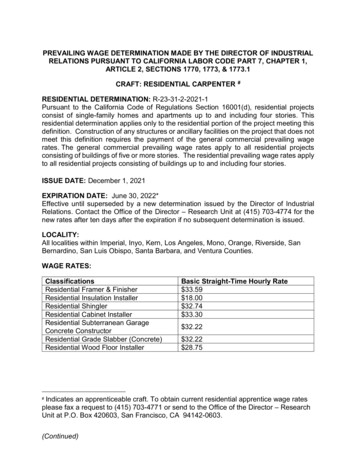
Transcription
by Alexander Din and Peter HanDoes the Inclusion of ResidentialNo-Stat Addresses Along RuralPostal Carrier Routes ImproveVacancy Rate Estimates?Alexander DinPeter HanU.S. Department of Housing and Urban DevelopmentThe views expressed in this article are those of the authors and do not represent the official positions orpolicies of the Office of Policy Development and Research, the U.S. Department of Housing and UrbanDevelopment, or the U.S. Government.AbstractBlighted housing is a problem in communities throughout the United States. Many definitions of blight anddata sources attempt to quantify and measure blight. One common measure of housing blight is housingvacancy, and one common data source for housing vacancy is the U.S. Department of Housing and UrbanDevelopment (HUD) Aggregated U.S. Postal Service (USPS) Administrative Data on Address Vacancies(USPS address data). This dataset provides granular and timely data into active and vacant housing.However, the USPS address data is not without its flaws. The label “not-a-statistic” (“no-stat”) to describehousing that is vacant, under construction, or otherwise not receiving mail is an ambiguous designationand has puzzled researchers. It is not possible to discern between no-stat for blight versus no-stat fordevelopment in the data. This error may lead researchers to false conclusions about housing vacancy orneighborhood characteristics of high housing vacancy areas if the housing vacancy rate is not accuratelycalculated. The label no-stat has even attracted Congressional attention to decipher no-stat for blightversus no-stat for development.1See 116th Congress. 2019. “H. Rept. 116-106 – Departments of Transportation, and Housing and Urban Development, andRelated Agencies Appropriations Bill, 2020.” h-congress/house-report/106/11Cityscape: A Journal of Policy Development and Research Volume 24, Number 2 2022U.S. Department of Housing and Urban Development Office of Policy Development and ResearchCityscape 69
Din and HanAbstract, continuedOne clue regarding no-stat addresses has not been investigated until this study. Letter carriers that workin rural postal carrier routes are instructed to label vacant addresses as no-stat (HUD, 2010; USPS,2019, 2013). No-stat addresses along rural routes (rural no-stats) are likely vacant addresses. This studytests if the inclusion of residential rural no-stat addresses better approximates the vacancy rate from theAmerican Community Survey (ACS) by benchmarking two measures of housing vacancy from the USPSaddress data: long-term (6 months or greater) residential address vacancy and long-term residentialvacancy plus residential rural no-stats. Because this research involves rural postal carrier routes, itcompares the two USPS-derived vacancy rates against the ACS vacancy rate and uses Rural-UrbanCommuting Area (RUCA) code geographies as a measure of rurality. The USPS vacancy rate that includesresidential rural no-stats more closely approximates the ACS vacancy rate overall. The improvement isparticularly better in non-core census tracts mostly served by rural postal carrier routes rather than citypostal carrier routes.IntroductionHousing vacancy is a problem in many communities throughout the United States (Accordino andJohnson, 2000; GAO, 2011). Structures that have been vacant for longer periods of time are a goodproxy for blight (Duke, 2012). Housing vacancy and blight have been linked to a number ofnegative phenomena such as reduced property values (Han, 2014), unpaid revenue collection(Accordino and Johnson, 2000), poor health outcomes (Katz, Barrie, and Carey, 2014; South,Holh, and Kondo, 2018; Wang and Immergluck, 2018), and crime (Branas et al., 2011; Branas etal., 2018; Garvin, Cannuscio, and Branas, 2013; Jay et al., 2019; Larson et al., 2019).Policymakers have sought help from analysts and researchers to identify housing vacancies andblight in their communities to remediate problems caused by housing vacancies. Hindering theirefforts is that housing vacancy and blight data can be difficult to measure and collect. Definingblight itself is a challenging concept to establish (Gordon, 2004). Gathering data on housingvacancy and blight is also challenging, particularly at granular levels of detail. Other data sourcessuch as 311 calls for service or housing vacancy often serve as a proxy to identify blight.There are several sources of housing vacancy and blight data. Some local jurisdictions use 311 callsas a proxy for blight (Athens et al., 2020), whereas a small number of other jurisdictions mayconduct surveys (Berland et al., 2020). The Housing Vacancy Survey (HVS) by the U.S. CensusBureau provides some useful information about vacant housing, but the survey is not granular; themost detailed estimates are at the metropolitan statistical area-level. The Census Bureau, throughthe decennial Census and American Community Survey (ACS), also collects information onhousing vacancies down to the neighborhood-level (census tract), which may be considered themost accurate housing vacancy data source (Molloy, 2016). However, census data is not withoutissues to analysts and policymakers. To achieve granularity, the Census Bureau uses statistical70 Measuring Blight
Does the Inclusion of Residential No-Stat AddressesAlong Rural Postal Carrier Routes Improve Vacancy Rate Estimates?sampling from 5-year rolling surveys to generate neighborhood-level data. There is also a dataavailability delay, as detailed data on neighborhood characteristics are released at the end of theyear following the last year of data collection (Census Bureau, 2022).2An alternative source of housing vacancy data at the census tract level is the HUD Aggregated U.S.Postal Service (USPS) Administrative Address Data on Vacancies (USPS address data). In additionto delivering the mail, letter carriers also collect delivery status information about the addressesproviding near real-time data about housing vacancies. The advantage of this dataset is that theinformation is collected daily by a workforce that serves every address in the United States and isreleased shortly after the end of each quarter.3USPS address data provides unique, neighborhood-level insight into housing vacancy throughoutthe United States. However, housing vacancy estimates from USPS address data are frequentlylower than from the ACS produced by the Census Bureau for a given area. Because the ACS andUSPS use different data collection sources and methods, it should not be expected that thesedatasets exactly match up. The source of the discrepancy may be related to the fact that the USPSuses two separate indicators for unoccupied housing. The first is the label “vacancy,” used when astructure is habitable, but the mail has not been collected for 90 days or longer. The second label is“not a statistic” (no-stat) which can indicate housing vacancy but may also indicate otherconditions such as a home under construction, two addresses merged, served by a post office box,demolished, or some other condition. There are no other variables in the data provided by theUSPS that describe why an address is listed as no-stat.Investigation into no-stat addresses could assist in estimating vacancy rates with USPS addressdata. Addresses along rural postal carrier routes are listed as no-stat if they are vacant for 90 daysor longer (HUD, 2010; USPS, 2019, 2013). Postal routes are described as city or rural; thedesignation is not necessarily a description of geography but is instead a description of paystructure. Letter carriers that work on city routes are paid an hourly wage whereas their rural routecounterparts are paid by a formula based on mileage and the number of stops. Because lettercarriers are instructed to mark vacant addresses as no-stat when the address is served by a ruralcarrier route, the inclusion of rural no-stats into the vacancy rate estimation will improve the USPSvacancy rate estimate. In this analysis, the USPS vacancy rate estimate is compared to the vacancyrate estimate from the American Community Survey.This study contributes to the literature in two ways. This is likely the first article investigatingresidential addresses coded as no-stats by the USPS along the rural postal carrier routes (ruralno-stats). First, the study examines residential addresses on rural postal carrier routes and whetherthey match with the addresses on rural areas by Rural-Urban Commuting Area (RUCA) codes.RUCA codes are neighborhood-level extensions of the Office of Management and Budget’s (OMB)definition of metropolitan, micropolitan, and non-metropolitan statistical areas. This is to establishif areas served by rural postal routes are considered rural by other metrics and because data onrural housing vacancy and blight is sparse (Eisenberg, 2018). Second, the study investigates the2The 2015–2019 5-Year American Community Survey dataset was released in December 2020.For example, data collected between October 1 and December 31 is delivered to HUD from the USPS in early January, andHUD typically posts fourth quarter data by the end of January.3Cityscape 71
Din and Handifferences and correlations between neighborhood-level estimates of housing vacancy from theCensus Bureau and no-stat addresses along rural routes by RUCA code are investigated. Theanalysis used data from the Census Bureau as a point of comparison against USPS address databecause of the data’s availability at small geographic scales and the frequent use of census data insocial science research, including housing vacancy.The structure of this article is divided as follows: The next section reviews the literature regardingUSPS address data. The subsequent section describes the datasets used in the analysis. Theanalytical strategy and results are reported after that. The last section discusses analysisimplications and future work plans.BackgroundStudies over the last several decades debated what to do about vacant, abandoned, and blightedstructures and property. Primarily, research into vacant and abandoned structures and the propertyhas been associated with poor financial impacts and economic stagnation or decline (GAO, 2011;Han 2014; Mallach, 2012; Wang and Immergluck, 2019; Whitaker and Fitzpatrick IV, 2013) anddeclining populations (Lee and Newman, 2017), whereas some researchers also note the potentialbenefits of leaving vacant properties as they are (Kelleher et al., 2020), research on vacant lots andstructures generally focuses how to transform the abandoned site into something more useful.The need for data has grown as more communities seek to address vacant housing problems;several studies utilize USPS address data to monitor and evaluate address vacancy as a proxy forblight. Silverman, Yin, and Patterson (2013) explored long-term (6 months or longer) residentialvacancy patterns in Buffalo, New York. Long-term vacancy increased as poverty rates, the share ofrenters receiving rental assistance, and the share of the Black population increased. Immergluck(2015) analyzed neighborhood characteristics associated with long-term vacancy to explore thehousing market recovery between 2011–2014. Although the United States generally experienced ahousing market recovery during this period, Immergluck observed that the recovery in long-termvacancy rates lagged in poor neighborhoods. Recently, Harrison and Immergluck (2021) used theUSPS address data to analyze neighborhood vacancy trends in the largest 200 metros in the UnitedStates with “hyper-vacancy” which represents census tracts with 8.0 percent or greater residentialvacancy and found a decline in these neighborhoods from 9.4 percent of all census tracts in thestudy area in 2012 to 7.5 percent in 2019. These studies use residential addresses that are listed asvacant, not no-stat, for 6 months or longer.Molloy (2016) investigated long-term vacancy in metropolitan areas to measure excess housingsupply noting the mismatch between the housing supply and demand could rise if the communityincludes a significant number of seasonal vacant homes and other homes intentionally left vacantwith no negative neighborhood consequences. Then Molloy employs a unique filter to USPSaddress data to align with the data from the Census Bureau. Molloy included no-stat addresses butdid not differentiate the data by postal route type—city or rural. Until now, Molloy’s methodologyof aggregating vacant addresses and no-stat addresses to determine the vacancy rate has not beencorroborated or duplicated, especially for rural areas.72 Measuring Blight
Does the Inclusion of Residential No-Stat AddressesAlong Rural Postal Carrier Routes Improve Vacancy Rate Estimates?Although a few studies concerning vacant and abandoned properties have been conducted toinclude rural regions as part of a broader study, most research on long-term vacancy and blight hasbeen conducted on a single city, region, or large metropolitan area (Harrison and Immergluck,2020; Hollander, 2011; Newman et al., 2016; Silverman, Yin, and Patterson, 2013). Rural areas inthe United States have distinct socioeconomic characteristics and unique challenges concerninghousing issues. Rural areas differ in housing needs and the resources they possess to address them.Rural areas have had declining population growth and out-migration for decades (Dobis et al.,2021). Johnson and Lichter (2019) observed that rural blight faces unique challenges such asdrastic population and resource decline, as 17 percent of non-metropolitan counties had lost overhalf their peak populations compared to about 1 percent of metropolitan counties losing the samepopulation in 2010. During the last century, rapid suburbanization of the United States also led toa population decrease across many rural areas, including people leaving agrarian communities andexiting urbanized communities in largely rural areas. Analysis found no studies using USPS addressdata to analyze vacant and/or blighted housing specifically in rural areas, although a few may haveincluded some rural areas as part of broader metropolitan regions. This article closes theknowledge gap by examining the vacant and abandoned residential addresses along the rural postalcarrier routes using the merged USPS address data and 2015–2019 5-Year ACS data.DataHUD Aggregated USPS Administrative Data on Address Vacancies (USPS Address Data)The primary dataset used in this analysis is the HUD Aggregated United States Postal Service (USPS)Administrative Data on Address Vacancies (USPS address data). This dataset contains administrativeinformation collected by the Postal Service’s letter carriers. In addition to delivering mail, lettercarriers also collect information about the addresses to which they are delivering the mail to improvedelivery. These data points primarily concern if mail can be delivered to an address. Letter carrierscollect this information which is imputed into the USPS’s Address Management System (AMS). Thisdata is aggregated to the ZIP 4 geographic level, which is then provided to HUD. A single ZIP 4centroid can be thought of as a block of rowhomes, a cul-de-sac, or a single floor of an apartmentbuilding. One ZIP 4 centroid typically has between one and 24 residential addresses.4 Only ZIP 4records which are associated with a residential, business, or other address type are provided to HUD.Postal box-only ZIP 4 records are not included in the dataset and the subsequent data productsreleased by HUD. In the fourth quarter of 2019, there were more than 37 million records in theZIP 4 extract containing over 154 million residential addresses.HUD uses a sublicense to share USPS address data to government entities and other non-profitresearchers. The data is aggregated to census tracts per the interagency agreement with the USPS.The USPS address data include counts of addresses where mail cannot be delivered. Letter carrierslabel these addresses either as no-stat or vacant; both indicate mail delivery is not possible at theaddress. There are also data points that describe how average length of vacancy or no-stat statusesThese are the 1st and 99th percentiles for residential addresses for ZIP 4 records with at least one residential address. Themedian is three residential addresses per ZIP 4. The maximum value was 1,038 residential addresses.4Cityscape 73
Din and Hanand other new descriptive fields such as the USPS preferred state and city names, count of newaddresses during that quarter, and addresses served by a drop stop (Din, 2021).Addresses labeled as no-stat can be listed for multiple reasons, including potential vacancy, thedemolition of a building (the address is kept in AMS), or new construction housing that has notyet begun to receive mail. The USPS states the following potential reasons why an address may belabeled no-stat (USPS, 2013)— New housing developments Vacant delivery points on rural routes Addresses for delivery points in gated communities (identified with a drop count on theaddress where all mail is delivered)Vacant addresses are addresses that have not collected mail for 90 days or longer. The descriptionvacant may be a proxy for blight but is not necessarily blight itself. For both descriptors, no-statand vacant, the USPS tracks how long an address has been in that status. Multiple variablesdescribe the length of vacancy in the data. In the literature, researchers generally divide the datainto short-term vacancies, (fewer than 6 months) and long-term vacancies, (greater than 6 months)because some level of short-term vacancy might be indicative of a healthy housing market(Mallach, 2018). The analysis focuses on long-term vacancies; short-term vacancies may also bemore difficult to pick up by a survey like the ACS.This study used the Carrier Route ID (CR) variable to identify ZIP 4 records along rural routes.The CR variable is a four-character variable that describes the route that a ZIP 4 falls along. Carrierroutes indicate a pay structure. Letter carriers working rural routes are paid based on a formula(USPS, 2022), unlike city letter carriers who receive an hourly wage. Therefore, rural defined bythe USPS is a description of the pay structure, not geography. The first character in the variabledescribes the type of route. The possible values for the first character of the CR are— B – P.O. Box C – City Delivery G – General Delivery H – Contract Rural Route R – Rural RouteThe study identified residential addresses along rural routes by analyzing ZIP 4 records with a CRvalue that began with either “H” or “R.” For the fourth quarter of 2019, there were slightly morethan 151 million residential addresses in the USPS address data, of which approximately 36.7percent were either along a rural route or contracted rural route. Addresses were aggregated to thecensus tract level for linkage with RUCA code and ACS datasets. Unlike the census tractaggregation file normally made available to governments and nonprofit researchers, the data are74 Measuring Blight
Does the Inclusion of Residential No-Stat AddressesAlong Rural Postal Carrier Routes Improve Vacancy Rate Estimates?sorted by postal carrier routes. Calculating the share of residential addresses that are along a rural(including rural contract) route allowed identification of USPS address data by route type.Rural-Urban Commuting Area CodesThe most recent RUCA codes are based on the 2010 Decennial Census; the 2006–2010 5-Year ACS,and codes categorize U.S. census tracts into 10 primary codes using measures of population density,urbanization, and daily commuting. Although similar in concept with the Office of Management andBudget’s (OMB) classification of county-level metropolitan (metro) and non-metropolitan(nonmetro) areas, RUCA codes identify urban cores and adjacent territories by using census tracts asgeographical building blocks to differentiate urban and rural areas. Census tracts equivalent to urbanareas are defined as metropolitan areas and classified as code 1, but Census tracts equivalent tourban clusters area defined as micropolitan and small town cores, so they are classified as codes 4and 7, respectively. RUCA codes were chosen to analyze rural geography because they describeevery census tract in the United States. This allows researchers to identify rural areas in metropolitancounties and urban areas in micropolitan counties and small-town areas (Hart, Larson, and Lishner,2005). For a full description of each RUCA code, refer to exhibit 1.Exhibit 1Primary Rural-Urban Commuting Area Codes, n MetropolitanRural-UrbanCommuting Area(RUCA) CodeClassification DescriptionMetropolitan area core: primary flow within an urbanized area (UA)Metropolitan area high commuting: primary flow 30% or more to a UAMetropolitan area low commuting: primary flow 10% to 30% to a UAMicropolitan area core: primary flow within an urban cluster of 10,000 to 49,999 (large UC)Micropolitan high commuting: primary flow 30% or more to a large UCMicropolitan low commuting: primary flow 10% to 30% to a large UCSmall town core: primary flow within an urban cluster of 2,500 to 9,999 (small UC)Small town high commuting: primary flow 30% or more to a small UCSmall town low commuting: primary flow 10% to 30% to a small UCRural areas: primary flow to a tract outside a UA or UCNot coded: Census tract has zero population and no rural-urban identifier informationSource: U.S. Department of Agriculture (USDA) Economic Research Service (ERS)American Community Survey Vacancy EstimatesACS started in 2004 to replace decennial census sample data as the primary source for detailedpopulation and housing data and provide data more frequently. The survey’s sample size of over 2million households is sufficient to provide annual estimates for nonmetro areas by state. However,for smaller geographic units such as census tracts, the Census Bureau aggregates and estimates theCityscape 75
Din and Hanaverage of 5 years of annual surveys (Census Bureau, 2021). This article uses the most recent5-year aggregate data at the time this article was written, covering 2015–2019.This analysis uses the ACS code Occupancy Status (B25002) to derive a vacancy rate. The codeB25002 provides three variables (1) a count of total housing units, (2) the count of occupiedhousing units, and (3) the count of vacant housing units (ACS, 2021). This study calculated therate of vacant housing at the census tract level for all 50 states and the District of Columbia. Next,the study merged ACS vacancy estimates with the USPS address data and RUCA codes at thecensus tract level. It was not expected that either the estimated ACS vacancy rate or the estimatedUSPS vacancy rate would represent the true vacancy rates of any geographical unit in a timeperiod. Large differences between the two data sources were treated as problematic; theneighborhood-level ACS data was used as a point of comparison because of the wide availabilityand usage of census data.AnalysisAlignment Between USPS Carrier Route Types and RUCA CodesThis study evaluated whether Census tracts with a greater share of residential addresses along ruralpostal carrier routes represent the rural areas in the United States. Even though rural carrier routesare designated as a formula-based pay structure rather than a geographical representation, ruralcarrier routes could also account for non-urban areas as well. Whereas some rural studies usemetro-nonmetro county classification by the OMB to analyze rural America, this analysis usedRural-Urban Commuting Area (RUCA) codes because it is a more delineated classification systemincorporating population density, urbanization, and daily commuting at the census tract level. Thestudy assessed alignment between the rural postal carrier routes and RUCA codes in terms ofresidential and no-stat addresses in each category.This study calculated the share of residential and no-stat addresses along rural postal carrier routesby RUCA code shown in exhibit 2. Codes 1, 4, and 7 provide the total address counts formetropolitan, micropolitan, and small town cores, respectively. Census tracts are included in thesecores if more than 30 percent of their population is in the urbanized area or urban cluster. Thesethree columns comprise most residential addresses in their respective groupings of metropolitan,micropolitan, and small town communities. In metropolitan areas (codes 1, 2, and 3, commonlyreferred to as metro by OMB definition), 87.5 percent of all residential addresses are in the core(see column 1 in exhibit 2), whereas even in small towns approximately 70.3 percent reside in thecore. In these metropolitan, micropolitan, and small town cores, residential addresses along ruralpostal carrier routes make up a smaller share of residential addresses compared with thesurrounding commuting areas, ranging from 23.9 percent in metropolitan cores to 35.1 percent inmicropolitan cores, and 44.4 percent in small town cores.76 Measuring Blight
Exhibit 2Count of USPS Address Data by Rural-Urban Commuting Area Code, lAddressesAlong RuralCarrier RoutesShare67MicropolitanCore: primaryHighLowCore: primaryflow within ancommuting: commuting:flow withinurban clusterprimary flow primary flowan urbanizedof 10,000 to30% or more 10% to 30%area (UA)49,999to a UAto a UA(large UC)Highcommuting:primary flow30% or moreto a large UC89Small TownCore: primaryLowflow within ancommuting:urban clusterprimary flowof 2,500 to10% to 30%9,999to a large UC(small UC)Highcommuting:primary flow30% or moreto a small UC10RuralAreasLowPrimary flowcommuting:to a tractprimary flowoutside a UA10% to 30%or UCto a small 4,410769,8654,660,4461,354,968612,9824,716,662 7.0%88.3%36.7%Total 74,17819,344,024Total No-StatResidentialAddressesAlong RuralCarrier eSources: 2019 fourth quarter USPS address data merged with USDA ERS defined RUCA codes; calculations performed by the authorsCityscape 77Does the Inclusion of Residential No-Stat AddressesAlong Rural Postal Carrier Routes Improve Vacancy Rate Estimates?TotalResidentialAddresses5
Din and HanThe number of addresses on rural postal carrier routes and the total number of addresses in eachRUCA category is more similar in the commuting areas surrounding the metropolitan, micropolitan,and small town cores. In codes 2, 5, and 8—areas of high-commuting in metropolitan,micropolitan, and small towns, respectively—the share of residential addresses along rural postalcarrier routes represents most residential addresses in each category. In high-commuting censustracts in metro areas, residential addresses along rural postal carrier routes comprise 85.5 percent. Incomparison, nearly all residential addresses in high-commuting micropolitan and small town censustracts are along rural routes at 94.1 percent each. In low-commuting census tracts (codes 3, 6, and9), the share of residential addresses along rural routes again rises to 91.4, 95.1, and 97.0 percent inmetropolitan, micropolitan, and small town census tracts, respectively. In completely rural areas(code 10), where the only commuter flow is to an area outside of an urbanized area or urbanizedcluster, 88.3 of residential addresses are along rural routes.Overall, about one-third, 36.7 percent, of all residential addresses are along the rural postal carrierroutes. In comparison, nonmetro areas by OMB definition contain only 16.9 percent of allresidential addresses. This analysis aligned rural postal carrier routes by utilizing RUCA codes,which identified non-urban core or cluster areas more precisely. The residential addresses alongcity routes tend to be concentrated in urbanized areas or urban clusters, particularly inmetropolitan and micropolitan areas. The smaller the overall community is, such as micropolitanor small town communities, the greater the share of addresses is along the rural routes. At the sametime, as commuting into urbanized areas or urban clusters falls, the share of addresses along ruralpostal carrier routes rises. The residential no-stat addresses total and along the rural postal carrierroutes have a similar trend as well. This study checked the persistence of these results over time bycalculating the proportion of residential addresses along rural postal carrier routes by RUCA codefrom 2012 to 2021, as shown in exhibit 3. This study uses years 2012 through 2021 because thiswas the full range of data available and after some adjustment of the use of no-stat addresses by theUSPS in their Move to Competitive Street Addressing program.78 Measuring Blight
Exhibit 3Share of Residential Addresses Along Rural Carrier Routes by RUCA Code, 201920202021Core: primary flow within an urbanized area 4.3%High-commuting: primary flow 30% or more to a 6%Low-commuting: primary flow 10% to 30% to a 5%Core: primary flow within an urban cluster of 10,000 to49,999 (large .5%High-commuting: primary flow 30% or more to a large 1%Low-commuting: primary flow 10% to 30% to a large 2%Core: primary flow within an urban cluster of 2,500 to 9,99943.7%(small UC)44.0%42.8%43.0%43
data. Addresses along rural postal carrier routes are listed as no-stat if they are vacant for 90 days or longer (HUD, 2010; USPS, 2019, 2013). Postal routes are described as city or rural; the designation is not necessarily a description of geography but is instead a description of pay structure.