Transcription
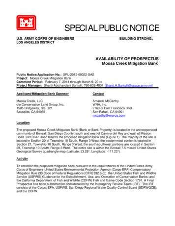
SPECIAL PUBLIC NOTICEU.S. ARMY CORPS OF ENGINEERSBUILDING STRONG LOS ANGELES DISTRICTAVAILABILITY OF PROSPECTUSMoosa Creek Mitigation BankPublic Notice/Application No.: SPL-2012-00022-SASProject: Moosa Creek Mitigation BankComment Period: February 7, 2014 through March 9, 2014Project Manager: Shanti Abichandani Santulli; 760-602-4834; on Bank SponsorContactMoosa Creek, LLCc/o Conservation Land Group, Inc.1505 Bridgeway, Ste. 121Sausalito, CA 94965Amanda McCarthyWRA, Inc.2169-G East Francisco BlvdSan Rafael, CA 94901mccarthy@wra-ca.comLocationThe proposed Moosa Creek Mitigation Bank (Bank or Bank Property) is located in the unincorporatedcommunity of Bonsall, San Diego County, south and west of Camino del Rey and east of MissionRoad. Old River Road bisects the proposed mitigation bank site (Figure 1). The majority of the site islocated in Section 20 of Township 10 South, Range 3 West; the easternmost portion is located inSection 21, Township 10 South, Range 3 West; the south/southwest portions are located in Section29, Township 10 South, Range 3 West. The entire site is within the Bonsall 7.5-minute United StatesGeological Survey quadrangle map (Latitude: 33.28 , Longitude: -117.22 ).ActivityTo establish the proposed mitigation bank pursuant to the requirements of the United States ArmyCorps of Engineers-United States Environmental Protection Agency (Corps-EPA) CompensatoryMitigation Rule (33 Code of Federal Regulations [CFR] 332.8(d)); the United States Fish and WildlifeService (USFWS) Guidance for the Establishment, Use, and Operation of Conservation Banks; andthe California Department of Fish and Wildlife (CDFW) Fish and Game Code Section 1797. A FinalProspectus has been submitted for consideration by the Interagency Review Team (IRT). The IRTconsists of the Corps, EPA, USFWS, San Diego Regional Water Quality Control Board (SDRWQCB),and the CDFW.
This Special Public Notice is a reissuance of the January 13, 2014 Special Public Notice for the sameproposed mitigation bank to ensure proper distribution and notification to all interested parties,including adjoining property owners.Furthermore, the Bank Sponsor, Moosa Creek, LLC, care of Conservation Land Group, Inc. (CLG),will hold a public meeting on February 24, 2014 at 6:00 PM at the San Luis Rey Downs Golf CourseClubhouse to present their proposal and address any questions about the proposed project.The San Luis Rey Downs Golf Course Clubhouse is located at 31474 Golf Club Drive, Bonsall,California 92003.Interested parties are hereby notified that a prospectus has been received for a proposed mitigationbank for compensatory mitigation for Department of the Army permits. Interested parties are invited toprovide their views on the proposed prospectus, which will become a part of the record and will beconsidered in the decision to authorize or not authorize the proposed mitigation bank.Comments should be mailed to:U.S. Army Corps of EngineersRegulatory DivisionSouth Coast Branch, Carlsbad Field OfficeAttn: Shanti Abichandani Santulli5900 La Place Court, Suite 100Carlsbad, California 92008Alternatively, comments can be sent electronically to: Shanti.A.Santulli@usace.army.mil.Evaluation FactorsThe decision whether to authorize the proposed mitigation bank will be based on an evaluation of theprobable impact, including cumulative impacts, of the proposed activity on the public interest. Thatdecision will reflect the national concern for both protection and utilization of important resources. Thebenefit which reasonably may be expected to accrue from the proposal must be balanced against itsreasonably foreseeable detriments. All factors which may be relevant to the proposal will beconsidered including the cumulative effects thereof. Factors that will be considered includeconservation, economics, aesthetics, general environmental concerns, wetlands, cultural values, fishand wildlife values, flood hazards, flood plain values, land use, navigation, shoreline erosion andaccretion, recreation, water supply and conservation, water quality, energy needs, safety, foodproduction and, in general, the needs and welfare of the people. In addition, if the proposal woulddischarge dredged or fill material, the evaluation of the activity will include application of the EPAGuidelines (40 CFR 230) as required by Section 404 (b)(1) of the Clean Water Act (CWA).The Corps is soliciting comments from the public; federal, state, and local agencies and officials;Indian tribes; and other interested parties in order to consider and evaluate the impacts of thisproposed activity. The District Engineer (DE) will review the comments received in response to thisnotice and make a written initial evaluation as to the potential of the proposed mitigation bank toprovide compensatory mitigation. To make this decision, comments are used to assess impacts onendangered species, historic properties, water quality, general environmental effects, and the otherpublic interest factors listed above. Comments are used in the preparation, if applicable, of an2
Environmental Assessment and/or an Environmental Impact Statement pursuant to the NationalEnvironmental Policy Act. Comments are also used to determine the need for a public hearing and todetermine the overall public interest of the proposed activity. In addition, all comments will bedistributed to the members of the IRT and the sponsor within 15 days of the close of the commentperiod. The DE and the IRT members will also have the opportunity to comment to the sponsor. Afterconsidering comments from the DE, the IRT, and the public, the Bank Sponsor will prepare a draftinstrument and submit it to the DE.BackgroundOn April 10, 2008, the Corps and the EPA published the Final Rule on Compensatory Mitigation forLosses of Aquatic Resources (“Mitigation Rule”), which went into effect June 9, 2008. The rulereplaced most previous guidance concerning compensatory mitigation.Consistent with the requirements of the rule at 33 CFR 332.8(d), the Bank Sponsor has submitted aprospectus to the Corps for the purpose of establishing and managing a mitigation bank consistentwith the Mitigation Rule. The Corps seeks comments from interested parties on the prospectus. Thispublic notice provides a summary of the mitigation bank prospectus submitted by the applicant. Thefull prospectus is attached to this notice with select figures. The full document may also be obtainedfrom the Corps by contacting Shanti Abichandani Santulli at Shanti.A.Santulli@usace.army.mil or(760) 602-4834. All figures and appendices can be obtained by accessing the Corps’ Regulatory Inlieu Fee and Bank Information System (RIBITS) website at http://geo.usace.army.mil/ribits/index.html(enter website, filter view to Los Angeles District, click on “Existing Banks & ILF Sites,” click on“Moosa Creek Mitigation Bank,” click on “Cyber Repository” in top right corner.)ObjectivesThe proposed mitigation bank is approximately 185 acres and currently supports approximately 37.96acres of wetlands and 5.72 acres (5,645 linear feet) of non-wetland waters. Implementation of theproposed mitigation bank will rehabilitate and re-establish riverine wetlands, depressional seasonalwetlands, wetland riparian, and non-wetland riparian, and restore and permanently protect coveredhabitat to mitigate for impacts authorized under the CWA Section 404 and 401, Section 1602 of theCalifornia Fish and Game Code, the Endangered Species Act (ESA), California Endangered SpeciesAct (CESA), and the California Environmental Quality Act (CEQA). Covered Habitat is defined in theFinal Prospectus as habitat of concern or habitat upon which a special-status species depends for itscontinued viability.The mitigation bank proposes to: Re-establish and rehabilitate wetland, stream and riparian habitat.Restore and preserve covered habitat for at-risk species known to occur, currently orhistorically, on the proposed mitigation bank site.Assist in the recovery and eventual removal of these species from their respective specialstatus lists.Allow the sale of compensatory mitigation and conservation credits, with approval fromappropriate agencies, as off-site mitigation for authorized impacts to regulated resourceswithin the respective service area.Service Area3
The proposed service area for Section 404/ 401 impacts (Figure 2) consists of the following subwatersheds as described by the 10-digit Hydrologic Unit codes:1807030303Lower San Luis Rey River1807030302Middle San Luis Rey River1807030304Escondido Creek1807030305San Marcos Creek—Frontal Gulf of Santa Catalina1807030205Santa Margarita River (including Camp Pendleton)1807030104San Onofre Creek—Frontal Gulf of Santa CatalinaEstablishment and Operation of the ProgramAfter completion of the Public Notice comment period, a BEI will be submitted for review by the IRT.The Bank establishment requires the following actions: The BEI must be fully executed by all of the applicable Signatory Agencies, The Conservation Easement has been accepted by a Grantee approved by the Corps andother applicable Signatory Agencies and recorded in the Official Records of the county inwhich the Bank Property is located, and; The Bank Sponsor has complied with its obligation to furnish the following financialassurances:o A Construction Security ensures that any construction will be completed as proposed.o A Performance Security ensures that constructed habitat will function as planned.o An Interim Management Security ensures that the Bank will be managed during habitatestablishment.o Letters of credit are submitted to and approved by the holding agency to satisfyfinancial assurance requirements.o An Endowment Fund ensures that there is adequate funding to provide for the financialrequirements of the long-term management of the Bank in accordance with the Longterm Management Plan.As part of the process of establishing a mitigation bank, the IRT would determine the types andnumber of potential credits that may be generated. Upon meeting either administrative milestones(e.g., BEI completion, funding of long-term management endowment) or performance-basedmilestones (e.g., 1-year, 3-year, 5-year conditional assessments), potential credits then becomereleased credits and are available for sale. In addition to the final IRT approvals of the Prospectus andBEI, the Bank Sponsor would also need to obtain the appropriate federal, state, and local permitsrequired to implement the restoration activities. The Bank Sponsor would submit an application forDepartment of the Army permit(s) should the proposed bank activities involve a discharge of dredgeor fill material within waters of the U.S. The Corps would complete consultation, if appropriate, underthe ESA, the National Historic Preservation Act, and other applicable laws, prior to any permitauthorization.Qualifications of the SponsorMoosa Creek, LLC, care of CLG, is overseeing the bank entitlement process and will serve as thelead contact for consultations with the signatory agencies. CLG will also manage the proposedmitigation bank once it is certified and operational, including handling mitigation credit sales andreporting to the signatory agencies. CLG specializes in facilitating and managing conservation and4
mitigation land transactions. CLG is thoroughly familiar with issues pertaining to real estate mattersincluding conservation easements, mineral rights, title encumbrances, hazardous waste issues andother related issues that need to be addressed as part of the establishment of a mitigation bank. CLGalso has extensive experience working in partnership with non-profit land conservancies that arepotential conservation easement holders for the proposed Bank Property.WRA, Inc. has been selected by the Bank Sponsor to support the entitlement of the Bank. WRA staffhas experience with a wide variety of habitat enhancement techniques, management tools, monitoringmethods, and bank design and entitlement. WRA has completed over 60 successful restorationand/or mitigation projects that have involved the combined input from hydrologists, engineers, agencystaff, and the public. WRA has prepared mitigation plans for a variety of systems, including wetlandhabitats (including tidal wetlands, freshwater marshes, vernal pools, and seasonal wetlands) andupland habitats (including riparian habitats and serpentine grasslands).Additional details are provided in the Prospectus, available online at the following link:http://geo.usace.army.mil/ribits/index.html. After clicking on the link,please follow the below steps: Under the Navigation Heading, click on “Banks & ILF Sites” Using the yellow drop-down arrow under the Banks and ILF Sites heading, filter state to “CA” Scroll down the alphabetized listing and click on “Moosa Creek Mitigation Bank” Click on “Cyber Repository” located underneath the frog image Click on “Documents for Review” Both the Prospectus and all figures and appendices are available in this folder. Please note thatthese files are large and may take several minutes to download.The Prospectus is also available at the Corps’ Los Angeles office at the address above.For additional information please call Shanti Abichandani Santulli at 760-602-4834 or via e-mail atShanti.A.Santulli@usace.army.mil . This public notice is issued by the Chief, Regulatory Division.Regulatory Program Goals: To provide strong protection of the nation's aquatic environment, including wetlands. To ensure the Corps provides the regulated public with fair and reasonable decisions. To enhance the efficiency of the Corps’ administration of its regulatory program.U.S. ARMY CORPS OF ENGINEERS – LOS ANGELES DISTRICTLos Angeles District Corps of EngineersRegulatory Division, Carlsbad Field Office5900 La Place Court, Suite 100Carlsbad, CA 92008WWW.SPL.USACE.ARMY.MIL5
Detail AreaBank PropertyAppendix A.Figure 1. Bank Property Location MapMoosa Creek Mitigation BankSan Diego County, CAPath: L:\Acad 2000 Files\22000\22159\gis\ArcMap\Final Prospectus\Fig1 LocMap 20130522.mxd.01Miles2Date: May 2013Map By: Chris ZumwaltBase Source: ESRI World Streetmap
CamiDnoReleyCamMoosa CreekMitigation BankSan Diego County,CaliforniainoDelRey76 «GolfubClDrAppendix A.Figure 3.Current Aerial Photographof Bank PropertyRveidr RLegendBank Property.0300600FeetMap Date: May 2013Map By: Chris ZumwaltAerial: NAIP 2012Path: L:\Acad 2000 Files\22000\22159\gis\ArcMap\Final Prospectus\Fig3 2012Aerial 20130523.mxd1,200
Moosa CreekMitigation BankSan Diego County,CaliforniaAppendix A.Figure 5.USGS TopographicMap.05001,000FeetLegendBank PropertyPath: L:\Acad 2000 Files\22000\22159\gis\ArcMap\Final Prospectus\Fig5 USGS Topo 20130523.mxdMap Date: May 2013Map By: Derek ChanBase Source: USGS2,000
Moosa CreekMitigation BankSan Diego County,CaliforniaAppendix A.Figure 7.100-Year Flood ZoneMap.LegendBank Property05001,000FeetFlood Zone0.2 Percent Annual Chance Flood Hazard100-year Flood ZonePath: L:\Acad 2000 Files\22000\22159\gis\ArcMap\Final Prospectus\Fig7 FloodZone 20130612.mxdMap Date: June 2013Map By: Derek ChanBase Source: FEMA, USGS2,000
Moosa Creek, LLC . c/o Conservation Land Group, Inc. 1505 Bridgeway, Ste. 121 . Sausalito, CA 94965 . Contact . Amanda McCarthy . WRA, Inc. 2169-G East Francisco Blvd . San Rafael, CA 94901 . mccarthy@wra-ca.com . Location . The proposed Moosa Creek Mitigation Bank (Bank or Bank Property) is located in the unincorporated