Transcription
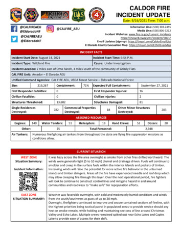
CALDOR FIREINCIDENT UPDATEDate: 9/16/2021 Time: 7:00 ALFIRE AEUInformation Line: (530) 303-2455Media Line: (530) 806-3212Incident Websites: www.fire.ca.gov/current ail Updates (sign-up): https://tinyurl.com/CaldorEmailListEl Dorado County Evacuation Map: https://tinyurl.com/EDSOEvacMapINCIDENT FACTSIncident Start Date: August 14, 2021Incident Start Time: 6:54 P.M.Incident Type: Wildland FireCause: Under InvestigationIncident Location: 2 miles east of Omo Ranch, 4 miles south of the community of Grizzly FlatsCAL FIRE Unit: Amador – El Dorado AEUUnified Command Agencies: CAL FIRE AEU, USDA Forest Service – Eldorado National ForestSize:219,267Containment:71%Expected Full Containment:September 27, 2021First Responder Fatalities:0First Responder Injuries:16Civilian Fatalities:0Civilian Injuries:2Structures Threatened:13,682Structures Damaged:81Single ResidencesDestroyed:782Commercial PropertiesDestroyed:18Other Minor StructuresDestroyed:203ASSIGNED RESOURCESEngines:140Water Tenders:Other:Air Tankers:2551Helicopters:18Total Personnel:Hand Crews:52Dozers:282,948Numerous firefighting air tankers from throughout the state are flying fire suppression missions asconditions allow.CURRENT SITUATIONWEST ZONESituation Summary:Incident Information:EAST ZONESITUATION SUMMARY:It was hazy across the fire area overnight as smoke from other fires drifted northward. Thewinds were generally light (5 to 10 mph) diurnal and drainage driven. Fuels will continue tosmolder and creep in the surface fuels within the interior islands and pockets of timber.Increasing winds will raise the potential for more active fire behavior in the unburnedislands and timber stringers. Areas of the fire have experienced needle and leaf drop whichmay allow creeping fire through this layer. Over the next operational period, fire fighterswill look to continue to construct control lines and mitigate hazard in and aroundcommunities and roadways to “make safe” for repopulation efforts.Weather was favorable overnight, with cold and moderately humid conditions and windsfrom the south/southwest at gusts of up to 20 mph.Overnight, firefighters continued to improve and secure contained sections of fireline, withthe highest priorities being tactical patrol in populated areas to provide service should anyheat or smoke remain, while holding and maintaining sections of line around ChristmasValley and Echo Lakes. Multiple crews remained spiked out near Echo Lakes and CaplesLake to provide ease of access for their shift.
Today, fire crews will continue to build containment on the fire by working west from EchoLakes into Desolation Wilderness and continuing to construct line in the Trimmer Peak,Convict Meadows and Margaret Lake areas.USFSFOREST INFORMATIONThe Region-wide Forest closure order will be terminated at 11:59 PM September 15, 2021 MORE: https://bit.ly/3Aewyw2 El Dorado National Forest: The Eldorado National Forest forest-wide closure (03-2114) remains in effect until September 30. Access and orders will be refined over time.MORE: https://www.fs.usda.gov/eldorado/ LTBMU: The Lake Tahoe Basin Management Unit closure order (19-21-05) remains ineffect for the following backcountry areas: Desolation Wilderness, Meiss Country,Barker Pass and McKinney/Rubicon through Sep. 19, 2021. Access and orders will berefined over time. MORE: https://www.fs.usda.gov/ltbmu/A Burned Area Emergency Response Team (BAER) has started evaluating the Caldor Firearea. This is a rapid assessment of burned watersheds by a BAER team to identifyimminent post-wildfire threats to human life and safety, property, and critical natural orcultural resources on National Forest System lands and take immediate actions toimplement emergency stabilization measures before the first post-fire damaging events.EVACUATIONSAMADOR COUNTYAMADOR COUNTY – ORDERS ZONE 4A- South of Highway 88 alongthe Amador/El Dorado County Linefrom Dufrene Road, north of the linedue East from Dufrene Road to theAmador/Alpine County Line, west ofthe line due south from Highway 88 tothe east end of Salt Springs Reservoir. ZONE 5A- South of Highway 88 alongthe Amador/El Dorado County Line,north of the line due east fromDufrene Road to the Amador/ AlpineCounty Line, east of the line due southfrom Highway 88 to the east end ofSalt Springs Reservoir, west of theAmador/Alpine County Line.AMADOR COUNTY – WARNINGS ZONE 4B- South of Dufrene Road due eastto the Amador/Alpine County Line, northof the Amador/Calaveras County Line,west of Panther Creek Road, east of theline due south from Highway 88 to theeast end of the Salt Springs Reservoir ZONE 5B- South of Dufrene Road due eastto the Amador/Alpine County Line, northof the Amador/Calaveras County Line,west of the Amador/Alpine County Line,East of the line due south from Highway88 to the east end of the Salt SpringsReservoir.View the interactive evacuation map here: https://tinyurl.com/AmadorEvacEVACUATIONSEL DORADO COUNTYEL DORADO COUNTY – ORDERS CAPLES CREEK - This section is south of Highway 50 east of Kyburz up to 41 MilestoneTract and south all the way to Highway 88 between 1 mile east of Mormon EmigrantTrail up to Caples Lake following the County Line. DESOLATION - This section extends south of the Placer County Line in the area of theRubicon Trail between Spider Lake and Sourdough Hill and extends south intoDesolation Wilderness all the way to Highway 50 to include the areas of RockboundLake, Rubicon Reservoir, Highland Lake, Horseshoe Lake, Schmidell Lake and TwinLakes south to Highway 50 between Wrights Lake Road and Twin Bridges. The easternedge of this area is in line with Clyde Lake and Pyramid Lake.Page 2 of 5
DESOLATION EAST - The area north of Echo Lake, following the Desolation Wildernessnorth staying west of Fallen Leaf Lake, Cascade Lake and Emerald Bay up to the PlacerCounty Line DESOLATION NORTH - This is the area of Desolation Wilderness south of the PlacerCounty Line extending to Emerald Bay but staying within Desolation Wilderness. GRIZZLY FLAT PROPER - The community of Grizzly Flats remains closed, with access viapermit only. South of the intersection of Cosumnes Mine Road and Sciaroni Road,north and east of the intersection of Grizzly Flat Road and Blue Mountain Road, west ofthe intersection of Capps Crossing Road and Cypress Point Drive. HEAVENLY - The entire Heavenly property and lands, extending northeast to the AlpineCounty Line and to the Nevada State line. HELL HOLE - Northeast of Highway 89, west of the Alpine County line, and south ofTahoe Paradise Golf Course. MET TO HWY 88 - South of Mormon Emigrant Trail to Highway 88. West on Highway88 to Hams Station. NORTH ECHO - North of Highway 50 between Twin Bridges and Echo Summit,extending to the north just past Upper Echo Lake. SOUTH ECHO - South of Highway 50 starting at Camp Sacramento to the top of EchoSummit then proceeding due south to the Alpine County Line. TRIMMER - The area east of Pioneer Trail to the Alpine County Line stopping south ofHeavenly Ski Resort, excluding all residences off Pioneer Trail. US 50 SOUTH TO KYBURZ - South of Highway 50 from Ice House Road to Silver ForkRoad, to include the community of Kyburz, excluding the area south of the south forkof the American River. East of Mormon Emigrant Trail to Highway 88.EL DORADO COUNTY – WARNINGS: CALDOR - East of North South Road, West of Service Road 09N78A, north of the MiddleFork of the Cosumnes River, south of Caldor Crystal Basin B: From Ice House Road east to the border of desolation wilderness andfrom the Placer County line, south to Granite Springs Road and the area south ofGranite Springs Road to Highway 50 at Wrights Lake Road CHRISTMAS VALLEY - All residences accessed from Highway 89 south of Highway 50 inMeyers through Christmas Valley and including all of South Upper Truckee. FALLEN LEAF C - The area of Fallen Leaf Road from Tahoe Mountain Road into the endof Fallen Leaf Road. The privately owned residences are open to be occupied underthis warning. The US Forest Service permitted residences must get an exemptionpermit from the US Forest Service prior to returning and that will likely be in the formof a day pass only. GREATER GRIZZLY EAST - South of Mormon Emigrant Trail, west of North South Road,north of Omo Ranch Road, east of the intersection of Omo Ranch and Slug Gulch Road,south of the Community of Blue Mountain, east of the intersection of Capps CrossingRoad and Cypress Point Road. MEYERS - All residences in Meyers north of Highway 89 and east of Highway 50 toinclude all streets accessed from Apache, Mandan, following Pioneer Trail northeastjust past Elks Club. PI PI - East of North South Road from Omo Ranch to Cat Creek and east to Highway 881 mile east of Omo Ranch Road.Page 3 of 5
EVACUATIONSALPINE COUNTYSOUTHEAST POLLOCK - North of Park Creek Road to Highway 50, east Fresh Pond toIce House Road. Due south from Ice House to the intersection of Mormon EmigrantTrail Intersection and west along Mormon Emigrant Trail Intersection to the Park CreekMormon Emigrant Trail Intersection.WASHOE MEADOWS / NORTH UPPER TRUCKEE - All streets accessed from NorthUpper Truckee Road which is north of Highway 50 stopping at Sawmill and Lake TahoeBlvd on the north side. This includes all residences on Sawmill and the residences tothe west of Highway 50 in Meyers to include Country Club, Bakersfield, East S andHopi.THE FOLLOWING STREETS IN EL DORADO COUNTY - Grizzly Flat Road between SteelyRidge Road and Blue Mountain Road. Cosumnes Mine Road between String CanyonRoad and the North Fork of the Cosumnes River. String Canyon Road between GrizzlyFlat Road and Eagle Hill Road.View the interactive evacuation zone and road closure map here:https://tinyurl.com/ElDoradoEvacALPINE EVACUATION WARNINGS: Zone 19 & Zone 20 - Highway 88 Pickett’s Junction south to Kirkwood and theAlpine/Amador County Linea. All areas to the west of Highway 88i. Red Lake, Caples Lake, Kirkwoodb. Wilderness and forested areas south of 88 and west of Blue Lakesii. Sisters, Fourth of July Peak, Fourth of July Canyon, Devils Corral, WinnemuccaLake, Frog Lake, Emigrant Peak, Elephants Back Zone 21A – Highway 89 at Pickett’s Junction west to the Alpine/El Dorado County Line Zone 22A – Pickett’s Junction Northeast to Fay Luther Canyona. Horse Thief Canyon to Fay Luther Canyon Zone 23 – Blue Lakes Rd. Upper Blue Lake, Burnside Lake & Rd., Elephants Graveyard,“The Patch”a. Forestdale Rd from Junction 88 to Upper Blue LakeALPINE COUNTY – ROAD CLOSURES & CONDITIONS UPDATE: Highway 88 has reopened from Pickett’s Junction to Kirkwood Meadows Dr.a. Highway 88 from Kirkwood Meadows Drive Westbound will remain closed at thistime due to fire activityView the interactive evacuation map here: https://tinyurl.com/AlpineEvacCOOPERATING AGENCIESAlpine County Sheriff's Department, Amador County Sheriff's Office, AT&T, Barton Health, Cal EMSA, Cal Guard, Cal OES Fire,Cal Trans, Campora, Carson City BLM, CCC, CDCR, CHP, Douglas County Sheriff's Office, El Dorado County Dept of Agriculture,El Dorado County Dept of Planning and Building, El Dorado County DOT, El Dorado County EMSA, El Dorado County Fire, ElDorado County OES, El Dorado County Office of Education, El Dorado County Sheriff's Office, El Dorado Hills FD, El DoradoIrrigation District, Fallen Leaf CSD Fire Department, Grizzly Flats Community Services District, Heavenly Ski Resort, KirkwoodMountain Resort, Liberty Utilities, Marshall Medical Center, Mosquito Fire Department, Nevada Department of EmergencyManagement, Nevada Department of Public Safety, Nevada Department of Transportation, Nevada Division of EmergencyManagement, Nevada Division of Forestry, Nevada Highway Patrol, North Lake Tahoe Fire Protection District, North TahoeFire Protection District, NV Energy, Paragon Gaming LLC, PG&E, Pioneer FD, Shingle Springs Band of Miwok Indians FD, Sierraat-Tahoe, SMUD, South Lake Tahoe EOC, South Lake Tahoe Fire Department, South Lake Tahoe Police Department, SouthPage 4 of 5
Lake Tahoe Public Utility, District, SWRCB, Tahoe Douglas Fire Protection District, Verizon, Volcano Telephone, WashoeEmergency Operations Center, Washoe Tribe of Nevada and California.To learn more about wildfire preparedness visit:www.readyforwildfire.orgPage 5 of 5
CALDOR FIRE INCIDENT UPDATE Date: 9/16/2021 Time: 7:00 a.m. INCIDENT FACTS Incident Start Date: August 14, 2021 Incident Start Time: 6:54 P.M. Incident Type: Wildland Fire Cause: Under .