Transcription
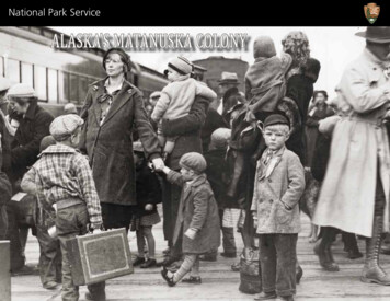
National Park ServiceALASKA’S MATANUSKA COLONY
The Department of the Interior (DOI) conserves and manages the Nation’snatural resources and cultural heritage for the benefit and enjoyment of theAmerican people, provides scientific and other information about naturalresources and natural hazards to address societal challenges and createopportunities for the American people, and honors the Nation’s trustresponsibilities or special commitments to American Indians, Alaska Natives,and affiliated island communities. DOI, https://www.doi.gov/about.The National Park Service preserves unimpaired the natural and culturalresources values of the National Park System for the enjoyment, education, andinspiration of this and future generations. The Park Service cooperates withpartners to extend the benefits of natural and cultural resource conservationand outdoor recreation throughout this country and the world.In keeping with our mission and programs, National Park Service staff preparedAlaska’s Matanuska Colony to help share a nationally significant story with thepublic and to support local community historic preservation stewardship.Published by the United States Department of the Interior, National Park Service,through the Government Printing Office. First Printing 2020.Front cover photograph: Matanuska colonists arriving atrailroad station, Palmer, May 23, 1935. Mary Nan Gamble.Photographs, 1935-1945, Alaska State Library-HistoricalCollections, ASL-P270-224.Back cover photograph: Colonist hauling logs for his cabin,1935. Mary Nan Gamble.Photographs, 1935-1945, Alaska StateLibrary – Historical Collections, ASL-P270-637.
ALASKA’S MATANUSKA COLONYBy Darrell LewisEdited by Janet ClemensGraphic Design by ArchgraphicsU.S. Department of the InteriorNational Park ServiceAlaska Regional OfficeHeritage Assistance Program
INTRODUCTIONThe story of the Matanuska Colony begins withthe Great Depression. Following the stockmarket crash of October 29, 1929, thousandsof banks and businesses failed, putting 25% ofAmerica’s workforce, over 15 million people, outof work. In 1930, as the financial crisis grippedthe nation, a severe drought swept across theGreat Plains. Farmers that had been strugglingwith low prices caused by over production werepowerless as their crops and soil dried up andblew away. Vast areas of farmland, as much as100 million acres, were made unusable. Withthe drought, farmers faced great difficultiesgrowing crops, and many lost their farms.“The land just blew away. We had to gosomewhere.”—Kansas minister on the road toCalifornia with his family, June atures/dustbowlgreat-depression/Farmer and sons walking in the face of a duststorm. Cimarron County, Oklahoma, 1936. Library ofCongress Prints and Photographs Division.
Lines stretched for blocks at soup kitchens in cities across the nation andmillions of people lost their homes. Hundreds of shanty towns sprung up inparks and vacant lots in cities across the nation. Many families were brokenup as millions of men and boys went out in search of work. In the Great Plainshuge dust storms darkened the skies. People caught in a dust storm comparedit to having a shovel of fine sand thrown into their face. Over the next ten yearsabout 3.5 million people migrated out of the Great Plains states to find workand better living conditions.Unemployed men lined up outside a depression soup kitchenopened in Chicago by Al Capone. ca. 1930 https://commons.wikimedia.org/wiki/Category:Soup kitchens#/media File:Unemployed men queued outside a depression soup kitchenopened in Chicago by Al Capone, 02-1931 - NARA - 541927.jpgThe double blow of financial collapse and extreme drought was more thanany state could manage on its own. United States President Herbert Hoover’sresponse was to focus on rescuing banks and industry. He believed that thiswould result in a trickle-down effect that would pull the nation out of thedepression. This may have eventually worked but the dire circumstances of theAmerican people could not wait. Franklin D. Roosevelt ran for president in1932 promising relief; promising direct assistance to the people. He wonnearly 60% of the vote, coming into office in 1933 with a mandate for action.The Farm Security Administration’s efforts in reaching out to help farm families impactedby the Depression included these exhibit posters titled “from” and “toward.” 1939. FarmSecurity Administration, Office of War Information Photograph Collection (Library ofCongress). Reproduction number LC-USZ62-122719.To ease the country’s economic problems PresidentRoosevelt spearheaded a series of relief, recovery andreform programs that were called “The New Deal”. Theprograms included the Resettlement Administration,Federal Emergency Relief Administration (FERA), andFarm Security Administration which were aimed at gettingdisplaced families off government provided relief andinto resettlement communities. Nearly 100 resettlementcommunities were established under these programs,including one in the Territory of Alaska called theMatanuska Colony. Today, much of the original MatanuskaColony remains that tells the story of the valley pioneersand the New Deal resettlement program.
THE GOVERNMENT’S NEW RElATIONSHIP WITH AMERICANSPresident Roosevelt’s New Deal relief, recovery, and reform programs changed theU.S. government’s relationship with the American people in dramatic ways. Forthe first time the U.S. government took an active role in ensuring the welfare ofthe citizens. Through the creation of the social security program workers wereguaranteed a pension for the first time and unemployment insurance provided anincome when workers became unemployed. Bank reforms such as the creationof the Federal Deposit Insurance Corporation protected people’s bank deposits.Through relief programs such as the Works Progress Administration and CivilianConservation Corps jobs were created for millions of out-of-work people. While therelief programs ended as the economy improved many of the reforms remained inplace and have been expanded.BACk-TO-lAND MOVEMENT:THE ROOTS OF NEW DEAl RESETTlEMENTAt the heart of the New Deal resettlement program was a growing support for gettingback to America’s agricultural roots, called a back-to-land movement. These movementsare not unique to the United States and often follow periods of great change andunrest. This was the case after the Civil War when the nation experienced increasingindustrialization and urbanization. The complexities and inequalities of a growing andchanging economy led many people to seek a simpler way of life. Throughout the late1800s and early 1900s a number of philanthropists and religious leaders embraced thisagrarian philosophy, establishing a number of small farm colonies across the nationaimed at relieving poverty and promoting a simpler lifestyle. The Great Depressionwas a powerful catalyst in favor of these ideals. The desperation of the times and theprogressive ideals of many in the Roosevelt Administration brought the back-to-landphilosophy into mainstream thinking. President Roosevelt signed the National IndustrialRecovery Act into law in June 1933, which included a provision for implementation of ahomestead program. Two months later the Division of Subsistence Homesteads, the firstNew Deal resettlement agency, was formed to provide safe residences for urban poor onsmall plots of land that would allow them to grow their own food.
““AmidAmid all our hopeshopes of industrial greatness,grgreeatneatness,ss, thethe land isthethe onlyonly realitreality.realityy. And,And, in hardhard times—etimetimes—everybodys—evverybodbodyy cancan seeseeit—cit—canit—canan seesee that the man wwhoho ownsowns the land, tills thetheland, liveslives bylivby the land, is thethe onlyonly indepeindeindependentpendendentnt man.”man.”—William E. Smythe, founder of the Little Landers movement,San Diego Union,Union, July 29, 1908.1908.The Union Colony of Colorado in 1870 was part ofAmerica’s early back-to-land movement. The Colonywas known for its success with irrigation. Here eightchildren (ages seven to twelve years) that work inthe fields pose for a photo on a sugar beet farm nearGreeley, Colorado, July 1915. Library of Congress Printsand Photographs Division.
”Nobody was interested in these people. They didn’t belong toany farm organization and usually their better off neighborseither used them for part time help or sharecroppers or somesuch way as this, and they were simply not interested in theirwelfare. They were an abandoned lot of people.”—Rexford Tugwell, Director of the Resettlement 714 from an interview by RichardDowd for the Archives of American Art New Deal and theArts Project on January 21, 1965.Nearly one-hundred New Deal Resettlement Communities were constructed from 1933 to 1940. Green dots represent farm communities and the red dotsrepresent non-farm communities. The Matanuska colonists traveled a long distance from the Upper Midwest, across the country by train, and then by shipto Alaska and finally by train to the colony site in Palmer. Shown are the distances that Matanuska colonists had to travel from San Francisco and Seattleto Alaska, after travelling from St. Paul, Minnesota. Map created by Vicki S. Vaden, Cumberland Homesteads, Tennessee, 2017. Adapted, with author’spermission, by Darrell Lewis, Historian, National Park Service.
RESETTlEMENT COMMUNITIES—TAIlORED TO FITDuring it’s nearly ten years in existence the New Deal resettlementprogram moved about 15,000 families into various types of plannedcommunities. Most New Deal resettlement communities wereestablished to assist farmers and workers displaced by the depressionand drought, to move farmers to better farmland, as well as to givetenant farmers an opportunity to own land, to get low-income familiesinto better housing, to provide laborers and factory workers with ahome and some land to grow their own food. The communities variedwidely in size, ranging from as small as ten homes to as large as nearly900 homes. Some were little more than a collection of homesteads neara town, while others were complete communities. The governmentworked hard to bring assistance to those in need, without burdeningthem with having to move great distances. Most resettlementcommunities were established within ten miles of those they wereintended to help. There were a few instances in which the families hadto move across their state or to a neighboring state but these were rare.Tupelo Homesteads in Mississippi, 1935. This settlement consisted of 35 three-acre subsistence homesteads. Note that each of the homes have the samedesign. Library of Congress Prints and Photographs Division.
In keeping with the back-to-land movement philosophy everyresettlement community had some kind of farming or gardeningelement. Some communities were planned for large scale farming wherefarmers made their living growing and selling farm goods. Some weredesigned with small garden plots so that laborers could supplementtheir income by growing their own food, and others provided a few acresto each family for subsistence farming. They were often constructednear towns to take advantage of existing infrastructure such as schools,hospitals, and stores. A few, like the Matanuska Colony, were completetowns that included schools, administration buildings, staff houses,hospitals, and factories or processing facilities. To get people off ofgovernment assistance and into new homes the government had towork quickly. To make planning and construction easier, buildingdesigns were often similar from one colony to the next. This planningincluded the expectation that each community member would workcooperatively for the benefit of the entire community.Children at play in Greenhills, Ohio, 1939. Note the mixed duplex and apartment stylehomes in the background. Greenhills was a garden city consisting of 737 homes andfarms. Garden cities provided housing for factory workers and were surrounded bya green belt that consisted of farms and open land. Library of Congress Prints andPhotographs Division.
Arthurdale, near Reedsville, West Virginia was the firstresettlement community established. Completed in 1937,Arthurdale consisted of 165 homesteads, established to assistout-of-work coal miners in the area. Constructed around acommunity center that included a school, health center, generalstore, and other services, each homestead included a large gardenintended to allow families to supplement their factory incomewith home grown food. Three factory buildings, a furniturefactory, a forge, and a tractor assembly plant were established onthe outskirts of Arthurdale. Another resettlement communitywas Dyess Colony, established in Mississippi County, Arkansas. Itwas similar to Arthurdale in that it was a complete community,however it was intended to provide tenant farmers and sharecroppers an opportunity to own land, and thus had no industrialfocus. Because of the concentration on farming as the primarysource of income, plots were larger, typically about 40 acres in size.Fairbury Farmsteads near Fairbury, Nebraska represented a moremodest effort to assist struggling families. Consisting of ten eightacre farmsteads and a 75-acre cooperative farming area, FairburyFarmsteads was intended to provide families on governmentassistance with an opportunity to improve their standard of livingthrough cooperative and individual farming.Homesteader at work in the cooperative furniture factory in Arthurdale, 1937. Arthurdale was establishedto assist unemployed coal miners in West Virginia. Library of Congress Prints and Photographs Division.
THE RESETTlENT PROGRAMAND AFRICAN-AMERICAN FAMIlIESAfrican-AmericanAfricanAmerican colonistscolonists at workwwororkk in a cooperativecoopercooperatiativve gardengardengarden at Gee’s Bend FarmsFarms in Alabama, 1939. Homes and farm buildings areare visible in the background.backgrbackground.ound. Gee’s Bendwaswas one of 17 resettlementresettlement communitiescommunities established toto assist African-AmericanAfrican-American families. LibraryLibrary of CongressCongressCongress Prints and PhotographsPhotPhotogrographsaphs Division.Division.
In 1930, two-thirds of all African-American farmers wereeither sharecroppers or day laborers, and 77% did not owntheir land. Initially, the New Deal hurt African-Americanfarmers. The Agricultural Adjustment Administration’s policyof paying land owners to plow up cotton fields or leave themfallow caused about 200,000 African-American owners,sharecroppers, and workers to be displaced. When thisbecame apparent, some of these policies were reversed andothers implemented to help relieve poverty. The resettlementprogram established 17 communities providing relief for2,000 African-American families living in the Southern U.S.Students rehearsingrehearsing the maypolemaypoledance for MaydanceMay Day,DaDayy, Gees Bend,Alabama, MayMay 1939. LibraryLibrary ofCongrCongressongressess Prints and .
WHY A RESETTlEMENT COMMUNITY IN AlASkA?
The Matanuska Colony did not follow the establishedpattern of the resettlement program of bringingassistance to those in need. There were nodire reasons within the Territory to establish aresettlement colony in Alaska. Farming in Alaskawas essentially a subsistence endeavor. There wereno out-of-work tenant farmers or share croppersin need of assistance. The devastating drought thatdestroyed crops and carried soil away in the GreatPlains States did not impact Alaska. The fishing andmining industries had been impacted by the GreatDepression but the effect was mild when compared tothe large numbers of those unemployed in the UnitedStates. Unlike most communities where the colonistsmoved to the next county or maybe across the state,Alaska was the only resettlement community in whichthe settlers had to travel thousands of miles to start anew life.The decision to establish a colony in Alaska waslargely economic and strategic. From the Departmentof Interior’s perspective, an increase in Alaska’spopulation would help the territory to becomeeconomically self-supporting. At the same time, theWar Department was looking to bolster Alaska’sdefenses in response to Japan’s increasinglyaggressive expansion. In planning for a build-up ofmilitary personnel, the development of large-scalefarming in the Territory would provide a morereliable and secure food source.View of Matanuska Valley, 1918. H.G.Kaiser, Alaska Railroad Collection;Anchorage Museum, B1979.002.AEC.G1001-AEC.G.1002 (two photosstitched together as a panorama).
THE DENA’INA—INDIGENOUS INHABITANTSThe mild climate and resources of the Matanuska Valleyhave long drawn people to the area. The Dena’inaAthabascans, the only coastal Athabascan group, displacedan earlier people in the area about 1,500 years ago.The Dena’ina hunted, fished, and gathered foodthroughout Southcentral Alaska. By the late 1700s,approximately 5,000 Dena’ina lived in semi-permanentvillages in the region.The Russian colonists introduced diseases which hada devastating effect on the Dena’ina population. Afterthe U.S. purchase of Alaska in 1867, Euro-Americansbegan moving into the Territory. In 1880, the U.S. Censusidentified seven Dena’ina villages in the Matanuska Valley.Soon gold seekers moved into the Matanuska Valley,followed closely by traders and merchants, and then byhomesteaders in the 1910s.During the 1920s, with their populations greatlydiminished by disease and loss of traditional hunting andfishing grounds, the Dena’ina abandoned many of theirvillages and moved into more permanent villages suchas Tyonek and Eklutna to be closer to schools, hospitals,stores and churches.Dena’ina Chief Stephan of Knik, serving from the 1890s to the 1910s. Shown wearingground squirrel parka, ceremonial headdress, and dentalium shell bandolier, andstanding in front of log building, circa 1907. C.B.M., Louis Weeks Collection; AnchorageMuseum, B2003.019.149.Today, opportunities to learn about the Dena’inaAthabascan in the Anchorage area include visiting theEklutna Village, Alaska Native Heritage Center, Anchorage Museum at Rasmuson Center, Dena’ina Civic and Convention Center, and the outdoorsculpture of Grandma Olga Nicolai Ezi, located at a former fish camp site along Ship Creek.
Dena’ina boys at Knik showing offoff their catch, ca. 1900. Knik was a Dena’ina village andsupply town for the WillowWillow CreekCreek Mining District, located about twenty miles west of thefuture site of the Matanuska Colony. Library of CongressfutureCongress Prints and Photographs Division.
AGRICUlTURE—AN EARlY SUCCESSIN THE MATANUSkA VAllEYThe Matanuska Valley is located in southcentral Alaska about 40 milesnorth of Anchorage. In 1934, when President Franklin D. Rooseveltdecided to establish a resettlement community in Alaska, the Valleywas considered to have good agricultural potential. Surrounded bymountains on three sides, the Valley is a broad basin drained by theMatanuska and knik Rivers. The mountains help shelter the Valleyfrom the severe winter temperatures of interior Alaska and from thestorms that come up from the Gulf of Alaska. Good soil, long summerdaylight hours, mild temperatures, and low precipitation make theMatanuska Valley one of the best places in Alaska for agriculture.Men and child with horse drawn potato digger in use,Matanuska Valley, Alaska, October 1918. H.G. Kaiser, AlaskaRailroad Collection; Anchorage Museum, B1979.002.AEC.G968.
Following gold discoveries in the mountains north of the MatanuskaValley in 1896, knik, a Dena’ina village about 20 miles from the futuresite of Palmer, became the supply town for the gold mines. In 1900,George Palmer, agent in charge of the Alaska Commercial Companystore at knik, planted a garden behind the store to see what he couldgrow. He had great success and within a short time other businessmenplanted gardens. By 1906, two small farms were selling produce tominers and villagers in the area. Demand for vegetables continuedto grow and by 1914 about 500 acres wereunder cultivation. Agriculture and coal fieldsin the mountains north of the future town siteof Palmer prompted the government to selecta route through the Matanuska Valley for theAlaska Railroad. As railroad constructionprogressed through the Valley from 1915-17strong demand for vegetables led to a surgein farming. When a 38-mile spur line wasconstructed north from the main line of therailroad to the coal fields in 1916, Matanuska, asmall town formed at the junction of the mainline and the spur line, and Palmer, a railroadsiding was established on the spur line aboutsix miles north of Matanuska. Homesteadersquickly established farms along the railroadtracks between Matanuska and Palmer. Inspring 1917, four-hundred settlers rushed toplant more potatoes and a record 1,300 tons ofpotatoes were produced that year.As farming and mining evolved, a crudesystem of trails were cut across the Valley.By 1934, the Alaska Road Commission wasmaintaining about 100 miles of graded roadsin the Matanuska Valley. knik had long beenabandoned, and Matanuska Junction andWasilla with populations of about 50 and 100,respectively, were the only towns in the Valley.It would be another two years before a road connected the MatanuskaValley and Anchorage. A freight train consisting of an engine, freightcar, and passenger car ran between Anchorage and Palmer once aweek. In emergencies an Alaska Railroad motorcar could transporta sick or injured person to Anchorage for care. Everything needed tobuild the colony would have to be carved from the land or brought infrom outside the territory.Except for ten miles of graveled roads most of the roads in the Matanuska Valley were graded dirt aspictured above in this 1934 image. View of horse drawn wagon coming down road, Matanuska Valley,Alaska. Oct. 1918. H.G. Kaiser, Alaska Railroad Collection; Anchorage Museum, B1979.002.AEC.G959.
ALASKA RAILROAD—EARlY BOOSTER FOR SETTlEMENT IN AlASkAThe government believed that more settlers along the railroad tracks wouldincrease demand for railroad passenger and freight services, and helpdecrease the Alaska Railroad’s debt. This view of a Matanuska Valley farmnear Palmer is an example of the kind of settlement the railroad was tryingto encourage, October 9, 1918. H.G. Kaiser, Alaska Railroad Collection;Anchorage Museum, B1979.002.AEC.G985.
The Alaska Railroad, completed in1923, provided a major year-roundlink from the port town of Seward,north to Anchorage, Palmer, and theinterior city of Fairbanks. The railroad,however, running a persistent debt,believed that increased settlementalong the railroad corridor wouldprovide a solution.Alaska’s population of 65,000 in 1916,had steadily decreased due to declinesin the mining and fishing industries,followed by World War I as men leftthe Territory to join the military.Following the war, few men returnedto Alaska, deciding instead to stayin the continental U.S. to enjoy theeconomic boom of the 1920s.The Matanuska Agricultural Experiment Station (building inbackground) was established in 1915. The U.S. Department ofAgriculture established several experiment stations in the Territory todetermine agricultural potential and to encourage farming. Imagetaken ca. 1920. Jack H. Floyd Collection; Anchorage Museum,B1957.005.188.The railroad and its promoters considered varioussettlement ideas to encourage newcomers to Alaska.In 1922, Territorial Governor Scott Bone made the firstpublic mention of a colonization plan in connection withthe railroad. In 1928, Otto Ohlson, General Managerof the Alaska Railroad, initiated a campaign to attractMidwestern farmers to Alaska. He convinced M.D.Snodgrass, Matanuska Agricultural Experiment StationManager and enthusiastic supporter of farming inAlaska, to lead the effort. By fall 1929, there were morethan 2,000 inquiries received and the effort seemedto be working. When the Great Depression struck inOctober of that year, the interest in Alaska farming driedup. A few farmers did move to Alaska, but most wereunable to sell their crops or farms at prices to make themove possible.While the Great Depression initially hadlittle effect on the Territory, soon Alaskawas caught up with the nation’s woes aswell as with efforts in providing relief tostruggling farmers." each adult farmer [is] worthabout 700.00 a year to the railroad.Enough of [that] kind of farmerwould make this railroad pay."—Captain Hughes, Alaska Railroad, 1924
DESPERATE TIMES—THE CUTOVER REGIONMany families struggled to make endsmeet during the Great Depression,such as Art Simplot family, shown infront of their house near Black RiverFalls, Wisconsin, 1937. Lee, Russell,1903-1986, photographer, FarmSecurity Administration-Office of WarInformation Photograph Collection,Library of Congress Prints andPhotographs Division.
“The encouragement of people by the land promotors, representingrailroad and logging companies and other large landholders tosettle the cutover lands heaped tragedy on tragedy.”—Vernon Jenson, Professor, Cornell University, 1945Clearing Cutover land required time and resources that many families did not have.Lon Allen and daughter sawing log on farm near Iron River, Michigan,1937. FarmSecurity Administration-Office of War Information Photograph Collection.The Matanuska colonists were selected from the relief rollsof the upper Midwestern states of Minnesota, Michigan, andWisconsin. Many of these people were already strugglingwhen the Great Depression struck. From 1870 to 1920,logging and mining had been the mainstays of these states.Millions of acres were clear cut, leaving a treeless, brushcovered landscape, dotted with tree stumps, called theCutover Region. As logging ended timber companies and landspeculators began marketing the land as farmland. It didnot matter that much of the land, with its thin, sandy layer oftopsoil was not well suited for farming. They misrepresentedits farming potential and sold the land cheaply. ManyEuropean immigrants and migrant families bought CutoverRegion land because it was cheap and discovered thatestablishing a farm was more difficult than they had beenled to believe. Unable to make a living off their farms, manybecame stranded and dependent on government relief tosurvive. Drought compounded the problem, making thesituation worse. In 1935, federal officials identified the areaas “one of the nation's critical social and economic problems,”observing that 70% of the population of Michigan’s UpperPeninsula were receiving government assistance. The NewDeal programs provided needed relief to these people.In selecting the colonists for the Matanuska Colony,Federal Emergency Relief Administration (FERA) officialsdrew comparisons between Alaska’s climate and that ofScandinavia, noting that Scandinavians were very successfulfarmers. They observed that the climate, soil, and agriculturalconditions of the Matanuska Valley were comparable to thoseof the northern Midwest and that many people from thisregion were of Scandinavian descent. FERA officials believedthat because of these similarities Midwestern people wouldbe best suited for the strenuous pioneer life and already havea knowledge of dairy and truck farming. In March 1935,county social workers were given the task of selecting a poolof possible applicants for the project.
THE JOURNEY NORTH—A NEW lIFE BECkONSAlaska bound Colonist family on board the St. Mihiel,Mihiel, leaving San Francisco, May 1, 1935. Dorothea Lange, Photographer, Farm Security Administration-Office of War Information Photograph Collection.
In April and May 1935, two hundredfamilies made the journey from Minnesota,Wisconsin, and Michigan to southcentralAlaska’s Matanuska Valley to start their newlives. They traveled in two groups from St.Paul, Minnesota by train to San Francisco,California or Seattle, Washington. From SanFrancisco and Seattle they travelled north,aboard the St. Mihiel, an Army transportship, through Alaska’s Inside Passage toSeward where they boarded an AlaskaRailroad train for the final leg of theirjourney to Palmer. Many had little time toprepare for the trip and most had nevertraveled so far from home. Nontheless thegeneral mood was one of excitement anddetermination."Give us a chance at that Alaska! Itwill take hard work, but we'll beworking for ourselves. And thatmakes the difference. This is a newlease on life for all of us."—Waldo Fox, former Michigan farmer,trapper and fox raiser, Ironwood DailyGlobe, May 17, 1935St. Mihiel leaving San Franciscowith first group of colonists onboard, May 1, 1935. DorotheaLange, Photographer, FarmSecurity Administration -Officeof War Information PhotographCollection.Colonist family on train in St. Paul,Minnesota getting ready to leavefor San Francisco, April 26, 1935.Dorothea Lange, Photographer,Farm Security Administration-Office of War InformationPhotograph Collection.
POSITIVE PROPAGANDAScene from Broadway play “200 Were Chosen,” November 1936. University of Iowa. Libraries. University Archives, Frederick W. KentCollection, 1866-2000, bldgs166-0002.jpg.The New Deal resettlement program was unpopular amongmany in Congress who saw it as wasteful, inefficient, andlacking a clearly defined mission. For some, communitieslike the Matanuska Colony were viewed as communistic andradical because of the collectivist nature of their governance.Resettlement program administrators needed positive newsto help foster support for the program and the MatanuskaColony provided that opportunity. Photographers andcinematographers traveled with the colonists, filming manyaspects of their experience. News of the colonists’ voyagewas reported widely in newspapers. Alaska’s mystique andthe long distance that the Matanuska colonists h
In keeping with our mission and programs, National Park Service staff prepared . Graphic Design by Archgraphics . U.S. Department of the Interior National Park Service . Shown are the distances that Matanuska colonists had to travel from San Francisco and Seattle to Alaska, after travelling from St. Paul, Minnesota. Map created by Vicki S .