Transcription
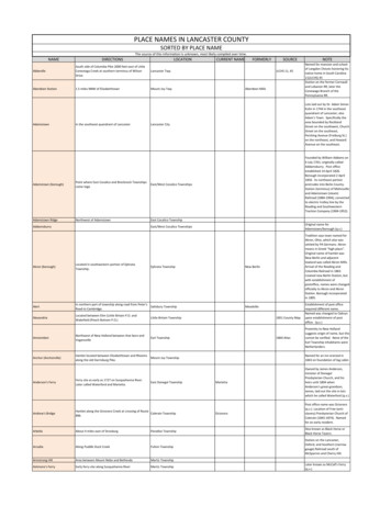
PLACE NAMES IN LANCASTER COUNTYSORTED BY PLACE NAMENAMEDIRECTIONSThe source of this information is unknown, most likely compiled over time.LOCATIONAbbevilleSouth side of Columbia Pike 2000 feet east of LittleConestoga Creek at southern terminus of WilsonDrive.Lancaster Twp.Aberdeen Station1.5 miles NNW of ElizabethtownMount Joy Twp.AdamstownIn the southeast quandrant of LancasterFORMERLYSOURCEJLCHS 11, 45Aberdeen MillsNOTENamed for mansion and schoolof Langdon Cheves honoring hisnative home in South Carolina11(JLCHS) 45Station on the former Cornwalland Lebanon RR, later theConewago Branch of thePennsylvania RR.Lancaster CityLots laid out by Dr. Adam SimonKuhn in 1744 in the southeastquandrant of Lancaster; alsoAdam's Town. Specifically thearea bounded by RocklandStreet on the southwest, ChurchStreet on the southeast,Pershing Avenue (Freiburg St.)on the northeast, and HowardAvenue on the southeast.Founded by William Addams on4 July 1761; originally calledAddamsburry. Post officeestablished 14 April 1826.Borough incorporated 2 April1850. Its northeast portionprotrudes into Berks County.Station (terminus) of Mohnsvilleand Adamstown (steam)Railroad (1884-1904); convertedto electric trolley line by theReading and SouthwesternTraction Company (1904-1952).Adamstown (borough)Point where East Cocalico and Brecknock Townshipscome togeEast/West Cocalico TownshipsAdamstown RidgeNorthwest of AdamstownEast Cocalico TownshipAddamsburryCURRENT NAMEEast/West Cocalico TownshipsOriginal name forAdamstown/borough (q.v.)Ephrata TownshipTradition says town named forAkron, Ohio, which also wassettled by PA Germans. Akronmeans in Greek "high place".Original name of hamlet wasNew Berlin and adjacentlowland was called Akron Mills.Arrival of the Reading andColumbia Railroad in 1863created new Berlin Station, butwith establishment ofpostoffice, names were changedofficially to Akron and AkronStation. Borough incorporatedin 1895.Akron (borough)Located in southwestern portion of EphrataTownship.AlertIn northern part of township along road from Peter'sSalisbury TownshipRoad to Cambridge.AlexandriaLocated between Elim (Little Britain P.O. andWakefield (Peach Bottom P.O.)New BerlinMeadvilleLittle Britain Township1851 County MapEstablishment of post officerequired different name.Named was changed to Oakrynupon establishment of postoffice. (q.v.)Proximity to New Hollandsuggests origin of name, but thiscannot be verified. None of theEarl Township inhabitants wereNetherlanders.AmsterdamNorthwest of New Holland between that boro andVogansvilleEarl TownshipAnchor (Anchorville)Hamlet located between Elizabethtown and Rheemsalong the old Harrisburg Pike.Mount Joy TownshipNamed for an inn erected in1843 on foundation of log cabin.East Donegal TownshipMariettaOwned by James Anderson,minister of DonegalPresbyterian Church, and hisheirs until 1804 whenAnderson's great-grandson,James, laid out the site in lotswhich he called Waterford (q.v.)OctoraroPost office name was Octoraro(q.v.). Location of Free (antislavery) Presbyterian Church ofColerain (1845-1874). Namedfor an early resident.Anderson's FerryFerry site as early as 1727 on Susquehanna River.Later called Waterford and Marietta.Andrew's BridgeHamlet along the Octoraro Creek at crossing of RouteColerain Township896.ArbellaAbout 4 miles east of Strasburg1864 AtlasParadise TownshipAlso known as Black Horse orBlack Horse Tavern.Station on the Lancaster,Oxford, and Southern (narrowgauge) Railroad south ofMcSparren and Cherry Hill.ArcadiaAlong Puddle Duck CreekFulton TownshipArmstrong HillArea between Mount Nebo and BethesdaMartic TownshipAshmore's FerryEarly ferry site along Susquehanna RiverMartic TownshipLater known as McCall's Ferry(q.v.)
AshvilleLocated east of Pine GroveAvataBachmantown1 mile southwest of SoudersburgLittle Britain TownshipTayloriaWest Donegal Twp.RheemsEast Lampeter Twp.Village along the SusquehannaRiver laid out in 1813 by HenryBrenneman and John Haldeman.Named to honor CommodoreWilliam Bainbridge, naval heroof the young republic. OriginallyBainbridge extended south toRace Street. The portion southof Race Street was developed byJohn Smith and John Seiple, andwas called Centreville. Laterboth villages were combinedwith the name Bainbridgesurviving.Located on the old Pennsylvania Canal and RoyaltonBranch of the former Pennsylvania Railroad.Conoy TownshipBalmerstownHamlet southeast of Talmage, northeast of CenterSquare, along Carpenter's Run.West Earl TownshipAlong Old Harrisburg Pike southeast of LandisvilleBard's HillBainbridgeSunnysideEast Hempfield Twp.Upper Leacock Twp.Also known as Snake Hill.Extends from Hunsecker nearthe conestoga River eastward toLeacock then in a northwestdirection along Bushong Road tothe Conestoga River nearStormstown.Village along the New Holland PikeBarney Google RowRow of dilapidated houses west of 500 block of SouthLancaster CityDuke Street.Upper Leacock TownshipBarevilleBarrensFulton TownshipBarr's QuarriesQuarryville BoroughBarrsvilleFulton-Little Britain TowBarrsvilleBart Post OfficeBart TownshipGeorgetownEstablished in 1738 from Drumore TownshipBartvilleA post office hamlet near the Colerain Township linealong the road from Puseyville to Nine Points.Batten's CornersNamed for early residents.This town was a mining hamletnamed for Charles Bamford,Englishman who developed thelead and zinc mines andsmelting works located adjacentto village and on present site ofKellogg plant.BarevilleBart TownshipRheemsHamlet named for JacobBachman, cabinetmaker andundertakerBainbridgeBamford, BamfordvilleHamlet named for Phineas Ash.Barrens1858 Scott MapEasternmost community of the"Tri-town group" (Leacock,Leola, Bareville); settled early19th century by Andrew andMartin BareNamed for comic stripcharacter. Removed in slumclearance project of 1960's.A broad band approximatelytwo (2) miles wide of gentlesloping hills and lowlandsdivided by the Conowingo Creekin lower Fulton Twp. Stands ofcedar trees characterize theBarrens.See Quarryville.Former name of Wrightsdale(q.v.)The official post officedesignation for Georgetown(q.v.)Bart TownshipTaken from Sadsbury Twp. in1744 and then included presentEden Twp. which was formed in1855. Bart allegedly was namedto honor sir William Keith,Baronet (abbreviated Bart) whowas governor of Pennsylvania,1717 -1726.LeolaEarly name of Leola.Bart TownshipUpper Leacock TownshipBaumgardnerPost office hamlet near Quarryville Branch of thePennsylvania RailroadPequea TownshipBaumgardner StationStation along the Quarryville Branch (nowabandoned) of the Pennsylvania Railroad atBaumgardner Post OfficePequea TownshipBausmanOn South side of Millersville Pike, west of CharlesRoadLancaster TownshipBean HillNear Thonsville off Wabank Road (extension ofWabank Street), northwest of Second Lock ofConestoga Navigation CompanyLancaster TownshipBeartownIn southwestern corner of township along Route 322 Caernarvon TownshipNamed for ThomasBaumgardner, local mill ownerand entrepreneur in 1870.BausmanPost office village laid out earlyin 20th century on Bausmanfarm by Charles O. LynchRolling hill named for numerousbean patchesNamed for tavern sign; formerlya post office town.
Station on the formerPennsylvania Railroad line thatconnected the Lancaster-NewHolland Branch to the EastBrandywine and WaynesburgRailroad that terminated atWaynesburg (Honey Brook). Ithad its own post office knownofficially as Narvon Post Office.Beartown StationA short distance south of Beartown on the formerPennsylvania RailroadBell BankNear Octoraro Creek downstream from Andrews'BridgeBellaire StationStation hamlet along the former Conewago Branch ofMount Joy Townshipthe Pennsylvania Railroad.Near the Dauphin County line atintersection of PA Route 241and Milton Grove Road.Post office hamlet one mile southeast of LeamanPlace where Quarry Road intersects Belmont Road.Bellemonte was on the formerPennsylvania Railroad until thetracks were moved north to theLancaster Pike to reduce curves.BellemonteBellevueBenton StationNorthwestern portion of Gap (q.v.) along Route 30(Lancaster Pike)Station along the Columbia and Port Deposit RR atmouth of Benton Hollow Run; Southwest of GreenePost OfficeCaernarvon TownshipNarvonHamlet is west of Bell's Bridge,where Mount Eden Roadcrosses Octoraro Creek. Namedfor Bell family, landowners.Colerain TownshipParadise TownshipSalisbury TownshipDrumore TownshipJacksonville & PuddingE & E 1046It was called Jacksonville andPuddington as well. Itsresidents' fondness for puddingsallegedly provided the originalname, and the hero of NewOrleans furnished the moreformal name, neither of whichenjoyed much favor. ReubenChambers, the eccentric editorof the Palladium, christianed thevillage Bethania of Biblical fame.BethaniaAlong the Strasburg-Gap Pk. near the R.R. west of Gap Salisbury TownshipBethelIn extreme northwestern corner of township, east ofLittle Britain TownshipRoute 222 and west of Fairmount.Name Biblical in origin.BethelstownArea between South Queen and South Water Sts. andLancaster Citysouth of West Strawberry Streets. Now the 4th Ward.Community developed bySamuel Bethel in what wouldbecome Lancaster city.BethesdaIn southwestern part of township, 2 miles northeastof HoltwoodMartic TownshipThe name is biblical in origin.Strasburg BoroughHow the village that wouldbecome Strasburg earned theunfortunate name that means"beggar houses" we cannot besure, but it was thought to bean improvement over theoriginal appellation of Hell'sHole. See Strasburg.BettlehausenBeverly StationBillmeyer, BillmyerStation on the former Cornwall and Lebanon R.R.,later the Conewago Branch of the PennsylvaniaRailroad.Company village at limestone quarry south of LocustGroveStrasburgMount Joy TownshipLocated 5 miles northeast ofAberdeen StationConoy TownshipLimestone was quarried andburnt to make lime by JohnHaldeman in 1845. By 1894operations under the John E.Baker Co. had progressed to thepoint where the employeesconstituted a "company town"The name was Derived fromMrs.Baker, maiden nameBillmeter. Quarrying operationsceased in 1957 and the pit waspermitted to fill up with waterin 1961.Conoy TownshipBicentenBinkleyHamlet at Binkley's Bridge and Binkley's Mill on theConestoga RiverManheim TownshipBinkleyBoth built by Christian Binkley inthe late 18th century; originallythe New Holland Turnpikecrossed over the bridge butafter its last destruction in theearly 1930s the road wasrerouted farther south. A postoffice operated out of theBinkley Tavern.Bird-in-HandPost office and R.R. station village along OldPhiladelphia Pike (King's Highway)East Lampeter TownshipBird-in-HandName derived from early innsign.BirdsNorth of Camargo in Northwest corner of EdenTownshipEden TownshipBitnervilleSouth of Columbia Avenue between Rider and WestAvenuesLancaster Township1851 MapAllegedly large flocks of birdsroosted in stand of trees.Named for Abraham Bitner,developer. Also known asWatch P.O. owing to itsproximity to Hamilton WatchCompany.
Black Barren, Black BaronBlack HorseFulton TownshipParadise TownshipBlack Oak HillLocated in Furnace Hills east of Cannon Hill andSeglock Run.Clay TownshipMiddle Creek is east of BlackOak Hill or Swartzaichle Barrick.Black RockAlong the West Branch of the Octoraro Creek nearthe Quarryville-Kirkwood RoadColerain TownshipCharcocal iron furnace and forgehamletBlackburnHamlet one (1) mile northeast of Mechanic Grovealong road connecting Puseyville to Route 222.East Drumore TownshipBlainsportBlue BallBlue RockOn Route 897 northwest of ReinholdsP.O. village at intersection of routes 322 and 23South of and adjacent to Washington BoroughBlue Rock FerryWest Cocalico TownshipEast Earl TownshipBonviewAlong Susquehanna RiverMartic TownshipBoughter's Row100 block of South Prince Street opposite St. Mary'sCatholic ChurchLancaster CityOn Route 625, south of the PA Turnpike (I-76)Brecknock TownshipBowmanvilleHamlet in southernmost part of townshipEast Earl TownshipBrecknock TownshipBrennemansBriartownBrickervilleEstablished in 1740 from Cocalico TownshipUS 322 & PA 501At junction of Routes 340 and 462 east of the city ofLancasterBridgevilleAlong 322BridgevilleAt intersection of Stacktown Road and Promontory south of mouth of Fishing CreekJust south of the intersection of Route 772 (NewportRoad) and Route 272 (Oregon Pike)Located near Hammer Creek north, northeast ofLexingtonStation at Silver SpringNorth of Lititz along Clay Rd. at Lexington Rd.Named for Samuel Bowman,early settler who was earlystorekeeper and justice of thepeace.Named for numerous Bowmanfamilies that lived there.BowmansvilleBridgeportSimpsonEast Earl TownshipAlso Sorrel Horse or FettervilleCTBP; 1864-1875MapsConoy TownshipSalisbury TownshipDrumore TownshipWest Earl TownshipWest Hempfield TownshipWarwick TownshipAt intersection of Routes 272 and 372Drumore TownshipBuena VistaAt intersection of Buena Vista Road and Mt. VernonRoad south of Route 340 (Old Philadelphia Pike)Salisbury TownshipColerain TownshipMarietta BoroughStrasburg TownshipConestoga TownshipPequea TownshipProperly, Ridgeville. One ofseveral designations for Lobatoor Stackstown.Scott 1823 MapBrownstownHamlet also known as BrubakerValleyElizabeth TownshipBuckBuyerstownBuzzard's GloryBuzzard's RockHoltwoodEast Lampeter TownshipBrecknock TownshipEasternmost section of Marietta1 1/2 miles south of StrasburgSouth of Shenk's FerryNorth of MarticvilleHamlet east of Churchtown between the ConestogaRiver and the Chester County lineOn Route 772 (Newport Road)Early name for White OakHollowAlso known as Boneview andMcCall's Ferry.White Oak HollowBrickervilleBrush TownButtertownBlue Rock was laid out 1814 byJoseph Charles. Named forlimestone outcrop; also knownas Charlestown.CharlestownMount Joy TownshipCaervarvon TownshipElizabeth TownshipGhost town in Brecknock Township nearBowmansvilleBull's HillBungletown (Moraviantown)Bunker Hill RidgeBurkholder's FerryBurnt MillBlue BallEden TownshipBowmansvilleBrinton's HollowBrown's PinnacleThe village grew up around theinn, Sign of the Blue Ball, builtby Robert Wallace in 1766.Route 322 (Old Paxtang Rd.) wasa heavily traveled wagon roadfrom Phila. via Downingtown toHarris Ferry, & Carlisle. Route23 (Horseshoe Rd.) now knownas the New Holland Pike, carriedtraffic between Lancaster andthe Schuylkill Valley.Manor TownshipLocated along Route 23 east northeast of Churchtown Caernarvon TownshipBridgeportReinholdsvilleManor TownshipBoggy HollowBoweryFormerly known asReinholdsville; the village waslaid out by John Ober and called"White Hall" in early 19thcentury. During 1850's SquireBenjamin Reinhold had villagenamed for himself. Owing toconfusion caused by ReinholdsStation about 2 miles south ofReinholdsville, the name waschanged to Blaisport supposedlyto honor James G. Blaine,prominent national Republicanpolitical figure, whoseforefathers lived in LancasterCounty.BrunnervilleSee Chapter Six in "The Peopleof Bowmansville" by Charles D.Spotts.Yellow HillName taken from name or signof tavern formerly located here.BuckE&E 684Caernarvon TownshipSalisbury TownshipEast Hempfield TownshipManor TownshipPromontory in Turkey Hill
ByerlandPequea TownshipCabbage HillThe 8th Ward of the city of LancasterCaernarvon TownshipCainsCaliforniaCamargoCambridgeCamp LancasterEstablished in 1729On Route 340 (Old Philadelphia Pike)Canes PointCannon HillCarter's HillCashtownCasseltownCat Tail VillageCatfishCedar GroveCedar HillCedar Lane P.O.Center SquareCentervilleCentral ManorCentre ChurchCentre SquareNorth of Quarryville on Carmargo RoadNorth of Route 340 (Old Philadelphia Pike0Finger of land creating bend in the Conestoga Riverbetween Wabank and Thonesville, between Secondand Third LocksHill in northeastern corner of township betweenFurnace Run and Seglock Run, NNE of ElizabethFurnaceLancaster CityKnown locally as Stick Barrick(PA. German).Elizabeth TownshipThe "Face on Carter's Hill" was alandmark for many years; it wasa plaster face or mask displayedin a high window in KateCarter's house.Located along Conowingo Road (Route 222) south ofFulton TownshipNew TexasTwo and a half miles east of IntercourseBetween Bethesda and Tucquan CreekNorth of Old LineSouth of TalmageManor TownshipRapho TownshipLeacock TownshipManheim TownshipMartic TownshipFulton TownshipEast Earl TownshipRapho TownshipEast Hempfield TownshipManor TownshipEast Earl TownshipWest Earl TownshipCentrevilleMount Joy TownshipBetween Chestnut Level and BethelManor TownshipCherry HillChestnut GroveChestnut HillChestnut HillChestnut LevelChickentownChickiesChickies RidgeFulton TownshipWest Donegal TownshipSadsbury TownshipWest Hempfield TownshipDrumore TownshipConoy TownshipWest Hempfield Twp.West Hempfield TownshipWest of Elizabethtown, west of NewvilleKreadyvilleSee Sporting HillSee OregonSee Sensenig1823 Scott's MapDrumore TownshipCharlestownRapho TownshipChristiana BoroChurchtownChurchtown Road StationClayClay TownshipClearfieldSadsbury TownshipCaernarvon TownshipCaernarvon TownshipClay TownshipOn Route 23On Route 322Established in 1853 from Elizabeth TownshipClonmellSee also Lobato, etc.See ChikiswalungoSouth of AdamstownOriginal name of creek whichflanked Rapho Township; theIndian name allegedly means"Place of the Crabs". The namealso is spelled Chicques andChiques or Chiquesalungoalthough these forms are notconsidered correct. Dr. SamuelS. Haldeman, a notedorthographer, claimed thecorrect spelling wasChikiswalungo and theacceptable abbreviated formwas Chikis. To further simplifymatters, Dr. Haldemanapproved the use of Chickies asa pragmatic alternative toChikis.Chartered 3/1/1894Erb'sProvidence TownshipColerain TownshipBrecknock TownshipSouthern extension ofBainbridgeOne of several names for MiltonGroveAlso known as Blue Rock (q.v.)Chickies Rock eastward to KinderhookStation near mouth of Chikiswalungo Creek along Pa.RR and Marietta Branch of the Reading and Columbia East Donegal TownshipRailroadChikiswalungoClover HillC.W. near Rocky SpringsPequea TownshipConoy TownshipChickies StationThe HillSalisbury TownshipCaernarvon TownshipEden TownshipSalisbury TownshipLancaster/West Lampeter TownshipsCentrevilleCentrevilleKnown also as simply "The Hill,"so-called from the hill---onwhich the heavily-Germancommunity is located. CabbageHill allegedly referred to thelarge amount of cabbagepatches cultivated in theneighborhood. "The Hill"community dates from the mid19th century when theareasouth and west of Dinah's Hill(Vine, Mulberry and WestStrawberry Streets) was settledby German and Irish immigrantsbecause low-cost housing nolonger was available in theearlier workingclassneighborhood of the 7th Ward.Mombert p. 351P.O. in Colerain Township. Alsoon 1864 Atlas
ClovertownCocalico HouseCocalico P.O.At intersection of Route 897 and Cocalico RoadWest Cocalico TownshipWest Cocalico TownshipCock's CombPromontory on Welsh MountainCaernarvon TownshipCoffee GossColemanvilleColerain(e) P.O.CollinsNear MaytownOn Route 324East Donegal TownshipConestoga TownshipColerain(e) TownshipColerain TownshipCollins' StationBetween Falmouth and BainbridgeConoy TownshipColumbiaConcordConestoga Center P.O.On Susquehanna RiverNear GordonvilleWest Hempfield TownshipLeacock TownshipConestoga TownshipConestoga JunctionConestoga TownshipConewago FallsConewago StationCordelia P.O.Cordelia StationCoulter's CornerCoveCow TownCramptownCresap's FerryCross KeysCrow HillCully's FallsCutler's PointDadoDekanogah (Conejoholo)Denver BoroughDevil's Race TrackDiamond StationDiller (Weavertown)DillervilleDinah's HillDissler P.O.DisstonDog PumpDogtownDonegal SpringsDonervilleDorsey StationDrumore CenterDrumore Post OfficeDrumore TownshipFalmouthEden TownshipTaken from West DonegalTownship, established in 1842.Established in 1842 from Donegal TownshipA hamlet located on the ridge of Chestnut Hillnorthwest of Ironville and northeast of Columbia.Station along Reading and Columbia RR southeast ofCordelia, the hamlet, and Ironville or Cordelia PostOffice1/2 mile north of BartvilleLocated along the Little Chickies Creek north ofMount Joy Borough, at the Mount Joy Water WorksS. Elizabeth St., MaytownCreswell Post OfficeCreswell StationRailroad and canal station (Lock#5) known earlier as Collins'Mill.Chartered 2/25/1814Junction of Pennsylvania RR with Cornwall & LebanonWest Donegal TownshipRR west of Elizabethtown near Conewago Creek.Conoytown or Conoy Indian TownCook's LandingAlong Susquehanna RiverCoopersvilleCopenhefferBetween Florinel and Silver SpringCordeliaAlso known as Cock's CombRocksNear MaytownPoint at which New Holland Branch of the oldPennsylvania Railroad left the main line east of theEast Lampeter Townshipbridge over the Conestoga River.Originally part of Chester County, established in 1729as part of Lancaster CountyConoy TownshipConnors MillConoy TownshipNeighborhood around countryhome of J.A. Myer; alsoCloverton.Immediately west of Norwood & north of the IronvilleWest Hempfield TownshipPikeConoy TownshipFulton TownshipSadsbury TownshipWest Hempfield TownshipWest Hempfield TownshipWest Hempfield TownshipIronvilleWest Hempfield TownshipBart Township1851 MapMount Joy TownshipEast Donegal TownshipLittle Britain TownshipManor TownshipAlso called Blue RockNamed for Postmaster GeneralJohn A.J. Creswell (1869-1874);Port Deposit native andDickinson College graduate.Manor TownshipStation along the Columbia and Port Deposit RRbetween Turkey Hill and Washington Boro; west ofCresswell Post Office"Situated upon a hill on the road leading fromMountville to Petersburg [now E. Petersburg] "On Susquehanna River between Fite's Eddy Stationand Fishing CreekNear Hershey Meetinghouse on Pequea CreekNear Washington Boro2 miles southeast of BowmansvilleNear AkronHamlet located about 1 mile SW of Ellsworth,between Intercourse and New HollandNorthwest of the city of LancasterPart of the 8th Ward of the city of LancasterSoutheast of LititzManor TownshipLeacock TownshipWest Hempfield TownshipE&E p.882Martic TownshipSalisbury TownshipManor TownshipWest Cocalico TownshipBrecknock TownshipEphrata TownshipSo called because of the numberof crows that once roostedthere.Named for the Cutler family thatlived in the areaDrumore TownshipBucher ThalChartered 9/4/1900Earl TownshipManheim TownshipArea located around Vine,Mulberry, and West StrawberryStreets. Named for DinahMcIntyre, former slave of theMatthias Slough family andfortuneteller at Slough's WhiteSwan tavern, who lived onStrawberry Street.Lancaster CityClay TownshipWarwick TownshipSalisbury TownshipFulton TownshipEast Donegal TownshipWest Hempfield TownshipStation on the Lancaster, Oxford and Southern RRbetween McSparren and Peach Bottom (Peters Creek Fulton TownshipPost Office).Located along Route 272 between Buck and ChestnutEast Drumore TownshipLevelDrumore TownshipOriginal township, established in 1729Dry TavernBrecknock TownshipDry WellsDrytownEden TownshipMartic TownshipBetween Rawlinsville and BethesdaIntercourseHopelandMillportSite of Asbury AME ChurchDonervilleFishing CreekDrumore TownshipSee Brecknock Township,Muddy Creek
DrytownDundeeDurlachEarl TownshipEast of Route 501 north of LititzNorth of Route 322 and south of the PA Turnpike (I76)Original township, established in 1729EarltownEarlvilleEast Cocalico TownshipEast ColumbiaEast Donegal TownshipEast Drumore TownshipEast Earl P.O.East Earl TownshipEast Hempfield P.O.East Hempfield TownshipEast Lampeter TownshipEast PetersburgEastlandEby'sEdenEden TownshipEdisonvilleEdwin P.O.Eldora StationElimElizabeth TownshipElizabethtownElliott's CornersEllsworth P.O.ElmElm LawnElstonville P.O.Elstow (Sahm's Store)Engletown (?)Enterprise P.O.Ephrata BoroEphrata TownshipErbdaleErb'sErb's MillFairfieldEstablished in 1838 from Cocalico TownshipEstablished in 1838 from Donegal TownshipEstablished in 1886 from Drumore TownshipEast of New Holland, south of Route 897Established in 1851 from Earl TownshipEstablished in 1818 from Hempfield TownshipEstablished in 1841 from Lampeter TownshipWarwick TownshipEarl TownshipEarl TownshipNew HollandWest Earl TownshipTalmageEstablished in 1838 from Cocalico TownshipHamlet adjacent to ClayEast Hempfield TownshipWest Lampeter TownshipLeacock TownshipPenn TownshipParadise TownshipPenn TownshipPenn TownshipConoy Township?East Lampeter TownshipEphrata TownshipTucquan Creek & River RoadAlong Slate Hill Road, south of Furniss RoadFairland P.O.At intersection of Fairland Road and Lexington RoadPenn TownshipFairmountAt intersection of Cedar Hill Road and Fairmount Road Little Britain TownshipFederal SpringFern CliffFern GlenFertilityFetterville P.O.Fiddler's GreenFifth LockNorth of Washington BoroOld Clay Street, LancasterAlong Conestoga River East Bank opposite CanesPoint, 3000 feet south of intersection of Bean HillRoad and Wabank Road.Benton Hollow Run at Susquehanna RiverRock Run at SusquehannaLocation of Lock 5 of Conestoga Navigation alongConestoga River at Rock HillWest Earl TownshipManor TownshipEast Earl TownshipConoy TownshipWest Hempfield TownshipWest Earl TownshipLancaster CityEast PetersburgChartered 1/1/1947Also called TurniptownElizabethtownElmChartered 4/13/1872Goodstown1851 MapBird-in-HandEphrata BoroChartered 8/22/1891ClayFairland P.O.FairmountTerre HillFalmouthCf. ConestogaNavigation Map rollNeffsvilleManor-Conestoga Twps.Fifth LockAlso site of hydroelectric plantFirst LockLock 1 was .75 mile south ofLancaster city and adjacent tothe South Sewerage TreatmentPlant along the New DanvillePikeLancaster/West Lampeter TFishing Creek StationAt mouth of Fishing Creek and Susquehanna RiverDrumore TownshipFivepointvilleFlickinger's StoreEast PetersburgDrumore TownshipDrumore TownshipEast Lampeter TownshipEast Earl TownshipManheim TownshipLocation of Lock 1 of the Conestoga NavigationSystem on the Conestoga RiverFive Points1899 AtlasLancaster TownshipFirst LockFite's Eddy StationEarliest name of New Hollandfrom c.1730 to c.1760; NewDesign replaced the nameEarltown about 1760, and thepresent name of New Hollandwas adopted about 1772.East Earl TownshipOn Route 23 (New Holland Pike) northeast of the cityManheim Townshipof LancasterEstablished in 1855 from Sadsbury TownshipW.Lampeter&Strasburg TwpFulton TownshipStation along the Lancaster, Oxford and SouthernRailroad (narrow gauge) near Edwin Post Office inFulton Townshipnorthern Fulton TownshipNear Oak HillLittle Britain TownshipEstablished in 1757 from Warwick TownshipEast end of VintageAt intersection of Route 72 and Newport RoadEllis & EvansWest Hempfield TownshipLittle Britain TownshipSalisbury TownshipIntersection of Route 222 and Penn Grant RoadLexingtonClay TownshipClay TownshipClay TownshipMartic TownshipDrumore Farmersville P.O.FeagleyvilleRapho Post Office? SeeNewtownRapho TownshipAlong the Columbia and Port Deposit RR southeast ofFernglen Post Office, and a short distance south ofDrumore TownshipSusquehannock State ParkJunction of Groffdale Church, Wissler, Fairmount,West Earl TownshipGroffdale and Amishtown RoadsOn Route 897Brecknock TownshipWest Cocalico TownshipSee also Sorrel HorseFive PointsCocalicoAlso called Dry Tavern
FlorinMount Joy/East Donegal ToFlorinelWest Hempfield TownshipForge HillHill adjacent to Lebanon County in Furnace Hills;located between Furnace Run on the east andHammer Creek on the west. North of Route 322.ForneyvilleFourth LockFrey's FallsFrogtownFruitvilleFrysvilleFulton HouseFulton TownshipFulton's FerryBetween Highville and Safe HarborOn Muddy CreekEstablished in 1844 from Little Britain TownshipFultonvilleFunk's DivisionEast of Washington BoroManor-Conestoga TownshipManor TownshipMartic TownshipManheim TownshipEphrata TownshipFulton TownshipA short distance downstreamwas hydroelectric plant on sie offormer paper mill. SeeSlackwater.Fourth LockMarticvilleFulton Township1851 MapManor TownshipScott 1823Range of hills along Lancaster-Lebanon CountiesPenn,Elizabeth,Clay TwpsFurniss P.O.Gable's ParkOff of Manor Ave./Millersville PikeDrumore TownshipManor TownshipRidge extending ENE from Gap100 block of East Fulton StreetSalisbury TownshipSalisbury TownshipLancaster CityGast's CourtOff of 400 block of Manor Street to Lafayette StreetLancaster CitySeven miles NE of QuarryvilleGibson's Cross RoadsBart TownshipCTBP ?Upper Leacock TownshipGobbler's KnobGockley P.O.Golden AcresGoodstownGoodville P.O.Gordonville P.O.Goshen P.O.Gossler GreenGovernor Hood HillGovernor's StablesGraeff's LandingGravel HillStrasburg TownshipWest Cocalico TownshipEast Hempfield TownshipLeacock TownshipEast Earl TownshipLeacock TownshipFulton TownshipColumbia BoroughRapho TownshipConoy TownshipLancaster TownshipEphrata TownshipNear SchoeneckBetween Centerville and BamfordNorthern part of the townshipNear AkronEarly designation for Bainbridge;also known as Logan's FerryGap HillGeorgetownLittle Britain TownshipGlenolaFulton HouseSee Stoner's FerryOn boundary line betweenFulton and Little BritainTownships along road fromWakefield to Kirk's MillsPart of the South Mountainfoothills. Named from numerouscharcoal iron furnaces in vicinityin late 18th and early 19thcenturies.Conoy TownshipGap HillGap P.O.Garrecht's RowGeorgetownLancaster Journal5/22/Conestoga TownshipFurnace HillsGalbraith's FerryForneyvilleNewspaper says: A post officehas been established atForneyville, in Earl township,Lancaster County, called "WestEarl Post Office,: John Forney,Esq. Post MasterElizabeth TownshipEarl TownshipLocation of Lock 4 of the Conestoga Navigation nearcrossing over the Conestoga River of SlackwaterMillersville Road south of Milllersville.Mount JoyVillage now incorporated withMount Joy Boro; it had its originas Hertzlertown when ChristianHertzler laid out lots in 1812.Officially the hamlet was namedSpringville, and later when apost office was established itwas named Spring Garden. In1880 the prevalence of placesnamed Springville and theSpring Garden prompted thenew name of Florin.LeolaEllsworthEnglsideHardscrabbleLaid out in 1819 by SamuelFerguson. Name originunknown. Also known earlier asHa
along the old Harrisburg Pike. Mount Joy Township Named for an inn erected in 1843 on foundation of log cabin. Anderson's Ferry Ferry site as early as 1727 on Susquehanna River. Later called Waterford and Marietta. East Donegal Township Marietta; Owned by James Anderson, minister of Donegal Presbyterian Church, and his heirs until 1804 when


![What's in a Name? Book of Mormon Language, Names, and [Metonymic] Naming](/img/33/whats-in-a-name-book-of-mormon-language-names-and-metonymic.jpg)