Transcription
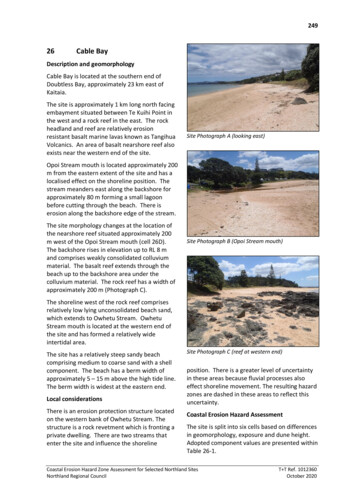
24926Cable BayDescription and geomorphologyCable Bay is located at the southern end ofDoubtless Bay, approximately 23 km east ofKaitaia.The site is approximately 1 km long north facingembayment situated between Te Kuihi Point inthe west and a rock reef in the east. The rockheadland and reef are relatively erosionresistant basalt marine lavas known as TangihuaVolcanics. An area of basalt nearshore reef alsoexists near the western end of the site.Site Photograph A (looking east)Opoi Stream mouth is located approximately 200m from the eastern extent of the site and has alocalised effect on the shoreline position. Thestream meanders east along the backshore forapproximately 80 m forming a small lagoonbefore cutting through the beach. There iserosion along the backshore edge of the stream.The site morphology changes at the location ofthe nearshore reef situated approximately 200m west of the Opoi Stream mouth (cell 26D).The backshore rises in elevation up to RL 8 mand comprises weakly consolidated colluviummaterial. The basalt reef extends through thebeach up to the backshore area under thecolluvium material. The rock reef has a width ofapproximately 200 m (Photograph C).Site Photograph B (Opoi Stream mouth)The shoreline west of the rock reef comprisesrelatively low lying unconsolidated beach sand,which extends to Owhetu Stream. OwhetuStream mouth is located at the western end ofthe site and has formed a relatively wideintertidal area.The site has a relatively steep sandy beachcomprising medium to coarse sand with a shellcomponent. The beach has a berm width ofapproximately 5 – 15 m above the high tide line.The berm width is widest at the eastern end.Local considerationsThere is an erosion protection structure locatedon the western bank of Owhetu Stream. Thestructure is a rock revetment which is fronting aprivate dwelling. There are two streams thatenter the site and influence the shorelineSite Photograph C (reef at western end)position. There is a greater level of uncertaintyin these areas because fluvial processes alsoeffect shoreline movement. The resulting hazardzones are dashed in these areas to reflect thisuncertainty.Coastal Erosion Hazard AssessmentThe site is split into six cells based on differencesin geomorphology, exposure and dune height.Adopted component values are presented withinTable 26-1.Coastal Erosion Hazard Zone Assessment for Selected Northland SitesNorthland Regional CouncilT T Ref. 1012360October 2020
250Histograms of individual components andresultant CEHZ distances using a Monte Carlotechnique are shown in Figure 26-1 to Figure 264.with the calculated values, although lines havebeen dashed around stream entrances to reflectthe increased uncertainty due to fluvialprocesses.Coastal Erosion Hazard Zone widths arepresented within Table 26-2 to 26-4 and Figure26-5. CEHZ’s have been mapped in agreementFigure 26-6 shows the available historicshorelines for Cable Bay.Table 26-1 Component values for Erosion Hazard AssessmentSite26. Cable BayCellCell MinDune/Cliffelevation (mabove toe orscarp)Stable angle(deg)Long-term (m)-ve erosion ve accretionClosure slope(beaches)SLR 2080 (m)SLR 2130 (m)26FEChainage, m (from .0450.045Max0.0260.0260.0260.250.0250.025RCP 2.60.160.160.160.160.160.16RCP 4.50.210.210.210.210.210.21RCP 8.5M0.330.330.330.330.330.33RCP8.5H 0.510.510.510.510.510.51RCP 2.60.280.280.280.280.280.28RCP 4.50.420.420.420.420.420.42RCP 8.5M0.850.850.850.850.850.85RCP8.5H 1.171.171.171.171.171.17ModeCoastal Erosion Hazard Zone Assessment for Selected Northland SitesNorthland Regional CouncilT T Ref. 1012360October 2020
251202020802130Figure 26-1 Histograms of parameter samples and the resultant shoreline distances for 2020, 2080 and 2130timeframes for cell 26A202020802130Figure 26-2 Histograms of parameter samples and the resultant shoreline distances for 2020, 2080 and 2130timeframes for cell 26B202020802130Figure 26-3 Histograms of parameter samples and the resultant shoreline distances for 2020, 2080 and 2130timeframes for cell 26CCoastal Erosion Hazard Zone Assessment for Selected Northland SitesNorthland Regional CouncilT T Ref. 1012360October 2020
252202020802130Figure 26-4 Histograms of parameter samples and the resultant shoreline distances for 2020, 2080 and 2130timeframes for cell 26D202020802130Figure 26-5 Histograms of parameter samples and the resultant shoreline distances for 2020, 2080 and 2130timeframes for cell 26E202020802130Figure 26-6 Histograms of parameter samples and the resultant shoreline distances for 2020, 2080 and 2130timeframes for cell 26FCoastal Erosion Hazard Zone Assessment for Selected Northland SitesNorthland Regional CouncilT T Ref. 1012360October 2020
253Table 26-2 Coastal Erosion Hazard Zone Widths for 2020SiteProbability of CEHZ (m) 16-1726. 7-18Coastal Erosion Hazard Zone Assessment for Selected Northland SitesNorthland Regional -21-22-23T T Ref. 1012360October 2020
254Table 26-3 Coastal Erosion Hazard Zone Widths Projected for 2080SiteCell26. Cable26ARCP 6-43-36-38-42-31-48T T Ref. 1012360October 20208.5 26F-5-9Coastal Erosion Hazard Zone Assessment for Selected Northland SitesNorthland Regional Council8.5 26E4.6MaxCEHZ18.5 26D-4-799%8.5 26C2.6MinProbability of CEHZ (m) Exceedance26B8.5 8.5
255Table 26-4 Coastal Erosion Hazard Zone Widths Projected for 2130Site26. CableCell26ARCP scenario8.5 26D8.5 26E8.5 70-46-52-68-81Max8.5 26C2.6MinProbability of CEHZ (m) Exceedance26B8.5 tal Erosion Hazard Zone Assessment for Selected Northland SitesNorthland Regional CouncilT T Ref. 1012360October 20208.5
26F26E26B26D26APath: P:\1012360\WorkingMaterial\GIS\CEHZ maps\1012360 CEHZ001 v2.mxd Date: 29/05/2020 Time: 6:09:35 am26CLEGEND2019 ShorelineCell ExtentCEHZ1CEHZ2CEHZ3Notes: Dashed CEHZ indicates greater uncertainty aroundstream mouths and backshore topography.Northland 0.4m Rural Aerial Photos (2014-2016).0A4 SCALE 1:4,0000.10.2 (km)!DRAWNCHECKEDAPPROVEDNORTHLAND REGIONAL COUNCILJJOU May.20Coastal Erosion Hazard AssessmentCable BayARCFILE1012360 CEHZ001 v2.mxdSCALE (AT A4 SIZE)105 Carlton Gore Rd, Newmarket, Aucklandwww.tonkintaylor.co.nz1:4,000PROJECT No.1012360FIGURE No.Figure 26-7Site: 26Rev.1
26F26C26EPath: P:\1012360\WorkingMaterial\GIS\CEHZ maps\1012360 Historicv2.mxd Date: 9/06/2020 Time: 9:26:30 AM26A26B26DLEGENDCell Extent2019 ShorelineHistoric 1966/06/151948/04/09Notes: Dashed CEHZ indicates greater uncertainty aroundstream mouths and backshore topography.Northland 0.4m Rural Aerial Photos (2014-2016).0A4 SCALE 1:4,0000.10.2 (km)!DRAWNCHECKEDAPPROVEDNORTHLAND REGIONAL COUNCILJJOU Jun.20Historic ShorelinesCable BayARCFILE1012360 Historicv2.mxdSCALE (AT A4 SIZE)105 Carlton Gore Rd, Newmarket, Aucklandwww.tonkintaylor.co.nz1:4,000PROJECT No.1012360FIGURE No.Figure 26-8Site: 26Rev.1
Coastal Erosion Hazard Zone Assessment for Selected Northland Sites T T Ref. 1012360 Northland Regional Council October 2020 . Cable Bay is located at the southern end of Doubtless Bay, approximately 23 km east of Kaitaia. The site is approximately 1 km long north facing embayment situated between Te Kuihi Point in the west and a rock reef in .