Transcription
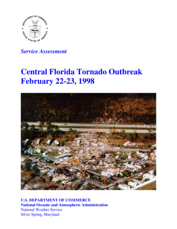
Service AssessmentCentral Florida Tornado OutbreakFebruary 22-23, 1998U.S. DEPARTMENT OF COMMERCENational Oceanic and Atmospheric AdministrationNational Weather ServiceSilver Spring, Maryland
Cover: Aerial view of the Ponderosa RV park in Kissimmee, Florida, showing a narrow path ofnearly total destruction. Three permanent structures in the park (office, laundry, shower/bathhouse) provided safe shelter. However, numerous fatalities occurred in this park. Photo courtesyof Robert Sheets.
Service AssessmentCentral Florida Tornado OutbreakFebruary 22-23, 1998June 1998U.S. DEPARTMENT OF COMMERCEWilliam M. Daley, SecretaryNational Oceanic and Atmospheric AdministrationD. James Baker, AdministratorNational Weather ServiceJohn J. Kelly, Jr., Assistant Administrator
PrefaceThe devastating tornadoes that struck central Florida the night of February 22-23, 1998,resulted in a decision by the National Weather Service (NWS) to conduct a Service Assessment.Service Assessments and their subsequent reports are used by the NWS to examine theperformance of its offices in providing timely warnings, accurate forecasts and other services toenable the public to minimize loss of life and property damage.The findings and recommendations developed by the Service Assessment Team will beincorporated into the ongoing process of improving NWS products and services to the citizens ofthe Nation.John J. Kelly, Jr.Assistant Administrator forWeather ServicesJune 1998ii
Table of ContentsPagePreface . . . . . . . . . . . . . . . . . . . . . . . . . . . . . . . . . . . . . . . . . . . . . . . . . . . . . . . . . . . . . . . .iiService Assessment Team . . . . . . . . . . . . . . . . . . . . . . . . . . . . . . . . . . . . . . . . . . . . . . . . . .ivAcronyms . . . . . . . . . . . . . . . . . . . . . . . . . . . . . . . . . . . . . . . . . . . . . . . . . . . . . . . . . . . . . .vEvent Summary . . . . . . . . . . . . . . . . . . . . . . . . . . . . . . . . . . . . . . . . . . . . . . . . . . . . . . . . . .1Facts, Findings and Recommendations . . . . . . . . . . . . . . . . . . . . . . . . . . . . . . . . . . . . . . . . .11Appendix A . . . . . . . . . . . . . . . . . . . . . . . . . . . . . . . . . . . . . . . . . . . . . . . . . . . . . . . . . . . . . A-1Appendix B . . . . . . . . . . . . . . . . . . . . . . . . . . . . . . . . . . . . . . . . . . . . . . . . . . . . . . . . . . . . . B-1iii
Service Assessment TeamThe NWS assembled this Service Assessment Team to analyze the overall warning processand to evaluate the services provided by the NWS to the state, county and local governments; themedia; and the public in Florida. The team traveled to Florida for the period February 25 - March2, 1998. Team members collected information and interviewed the Next Generation WeatherRadar (NEXRAD) Weather Service Office (NWSO) Melbourne staff; state, county and localemergency management personnel; law enforcement; other local officials; the media; and residentsof the impacted areas. Additional information was collected from the Storm Prediction Center(SPC) and Weather Service Headquarters (WSH). All of the information was then compiled andevaluated culminating in this report.The team was comprised of the following individuals:Lynn P. MaximukTeam Leader, Meteorologist in Charge (MIC), NWSO Pleasant Hill,MissouriDonald W. BurgessChief, Operations Training Branch, Operational Support Facility (OSF),Norman, OklahomaGary R. WoodallWarning Coordination Meteorologist (WCM), Meteorological ServicesDivision, Southern Region Headquarters, Fort Worth, TexasJames B. LushineWCM, NEXRAD Weather Service Forecast Office (NWSFO) Miami,FloridaPatrick J. SlatteryPublic Affairs Specialist, Central Region Headquarters, Kansas City,MissouriWalter G. Peacock, PhDAssociate Director for Research, International Hurricane Center, FloridaInternational University, Miami, FloridaOther valuable contributors include:William H. LernerWSH, Office of Meteorology, Silver Spring, MarylandRainer N. DombrowskyWSH, Office of Meteorology, Silver Spring, MarylandJoseph T. SchaeferDirector, SPC, Norman, OklahomaPeter A. BrowningScience and Operations Officer (SOO), NWSO Pleasant Hill, MissouriLinda S. KremkauTechnical Editor, WSH, Office of Meteorology, Silver Spring, Marylandiv
SOOSPCSPSSVSTDATDWRWCMWDSSWSHWSR-88DWISEAutomated Field Observing SystemAutomated Weather Interactive Processing SystemConsole Replacement SystemCounty Warning AreaEmergency Alert SystemState Satellite Communication SystemEastern Standard TimeFederal Aviation AdministrationFalse Alarm RatioHazardous Weather OutlookIntegrated Terminal Weather SystemMeteorologist in ChargeNext Generation Weather RadarNational Oceanic and Atmospheric AdministrationNational Severe Storms LaboratoryNOAA Weather RadioNational Weather ServiceNEXRAD Weather Service OfficeNEXRAD Weather Service Forecast OfficeOperational Support FacilityPersonal ComputerProbability of DetectionPrincipal User ProcessorRemote On Air Monitoring SystemRadar Product GeneratorScience and Operations OfficerStorm Prediction CenterSpecial Weather StatementSevere Weather StatementTornado Detection AlgorithmTerminal Doppler Weather RadarWarning Coordination MeteorologistWarning Decision Support SystemWeather Service HeadquartersWeather Surveillance Radar-1988 DopplerWarning and Interactive Statement Editorv
Event SummaryOverviewAn outbreak of unusually strong tornadoes in east-central Florida during the late night andearly morning hours of February 22-23, 1998, was the most deadly in the state’s history.Between approximately 11 p.m. and 2:30 a.m. Eastern Standard Time (EST) (EST will be usedthroughout this report), seven tornadoes swept through the NWSO Melbourne county warningarea (CWA), killing 42 people and injuring more than 260 others. The previous high tornadodeath toll in Florida was 17, which occurred on March 31, 1962, in the Florida Panhandle (SantaRosa County). In terms of single-event, weather-related fatalities in Florida, this event ranks asthe ninth greatest in loss of life. The largest number of single-event, weather-related deaths inFlorida occurred during the 1928 hurricane that killed more than 1,842 people near LakeOkeechobee.The tornadoes were unusually strong for the area and produced damage estimated in excessof 100 million. Three of the storms were rated in the F3 category (158-206 mph) on the FujitaTornado Intensity Scale (see Appendix A). More than 3,000 structures were damaged and morethan 700 destroyed. This Service Assessment focused on the NWSO Melbourne CWA, althoughthere were two brief tornado touchdowns in the NWSO Tampa Bay CWA earlier in the evening.Storm SummaryDuring the evening of February 22, the atmosphere over east-central Florida was primed fora devastating severe weather outbreak (Figure 1). A strong upper trough associated with astronger-than-normal subtropical jet stream (wind speeds of 140 knots) was approaching theFlorida Peninsula from the west. From a surface low near Mobile, Alabama, a surface cold frontarced southeastward over the Gulf of Mexico, nearing the western Florida coast. A line ofthunderstorms was moving eastward just ahead of the frontal boundary. Afternoon pre-frontalthunderstorms over southern Georgia and northern Florida had left behind a surface outflowboundary, stretching from near Daytona Beach on the east coast to northeast of Tampa on thewest coast. The air mass south of the outflow boundary and east of the front was warm, moist,and very unstable. The formation of a strong, nocturnal, low-level jet (winds greater than 50knots just 1,000 feet above ground level) was coupled with the subtropical jet further aloft toproduce very strong vertical wind shear over the peninsula.Three supercell thunderstorms formed as the storm line moved ashore from the Gulf ofMexico and interacted with the stationary outflow boundary, the instability, and the strong windshear. Supercell storms are hazardous because they last for long periods of time, rotate, and arethe parents of many strong and violent tornadoes. As the three supercells quickly moved acrosseast-central Florida, they produced seven tornadoes in the NWSO Melbourne CWA (Figure 2).1
Figure 1. Synoptic Setting, 7 p.m. EST, February 22, 1998.2
#1#2#3#4#5#6#7F2 tornado touched down in Volusia County at 10:55 p.m.—1 fatality, 3 injuries.F3 tornado touched down in Lake County at 11:37 p.m., entered Orange County at 11:41 p.m., first fatalitiesaround 11:50 p.m., lifting at midnight—3 fatalities, approximately 70 injuries.F3 tornado touched down in Seminole County at 12:10 a.m., first fatalities around 12:15 a.m. near Sanford, liftingat Volusia County at 12:25 a.m.—13 fatalities (12 - Seminole County, 1 - Volusia County), approximately 36injuries.F3 tornado touched down in Osceola County at 12:40 a.m., first fatalities at 12:50 a.m. in Kissimmee, crossedinto Orange County at 12:55 a.m., lifting at 1:28 a.m.—25 fatalities, 150 injuries.F2 tornado touched down in Volusia County at 12:45 a.m.—no fatalities or injuries.F1 tornado touched down in Brevard County at 1:38 a.m.—no fatalities or injuries.F1 tornado touched down in Brevard County at 2:30 a.m. near Port Canaveral—no fatalities or injuries.Figure 2. Central Florida Tornadoes, February 22-23, 1998.3
The northern supercell produced two brief tornado touchdowns in rural Sumter County in theNWSO Tampa Bay CWA shortly before 10 p.m. Later, that supercell produced a strongertornado that struck just southwest of Daytona Beach (Volusia County) at 10:55 p.m. Thistornado continued east-northeastward for approximately 8 miles, dissipating in southern DaytonaBeach. Tornado #1 (Figure 2) resulted in one fatality along Route 92 east of Interstate 95, threeinjuries, and damage to or destruction of more than 600 structures (F2 category on the FujitaTornado Intensity Scale).The middle supercell produced the first of its tornadoes (#2 on Figure 2) at 11:37 p.m. inrural eastern Lake County. Tornado #2 was not very destructive until it moved into westernOrange County at 11:41 p.m., severely striking Winter Garden and Ocoee between 11:47 and11:55 p.m. Tornado #2 (approximately 18 miles long) ended about midnight near theOrange/Seminole County line. In all, tornado #2 was responsible for three fatalities in WinterGarden, approximately 70 injuries, and damage to or destruction of about 500 structures (F3category).The middle supercell’s next tornado (#3) formed in Seminole County just northeast ofLongwood at 12:10 a.m., February 23. It moved northeast for 14 miles, hitting severalneighborhoods in the southeast portion of Sanford. Tornado #3 dissipated just after crossing theSt. Johns River in Volusia County at about 12:25 a.m. Along the path of tornado #3, there were13 deaths, 36 injuries, and damage to or destruction of more than 625 structures (F3 category).Twelve of the deaths were in Seminole County, and one was along Route 46 in Volusia County.The last tornado (#5) from the middle supercell struck rural eastern Volusia County about12:45 a.m., crossing Interstate 95 and damaging only a few structures (F2 category). Nocasualties were reported from tornado #5.The southern supercell produced the longest tornado track of the outbreak (tornado #4).The tornado first touched down at 12:40 a.m. in northwest Osceola County just southwest ofKissimmee and moved northeastward for about 38 miles, dissipating in extreme eastern OrangeCounty at about 1:28 a.m. The first tornado fatalities occurred at approximately 12:50 a.m. in thePonderosa RV Park. The tornado’s touchdown point was approximately 8 miles southeast ofcentral Florida’s popular area of theme parks, entertainment centers, and hotels/motels. Damagefrom tornado #4 was severe in southern, eastern, and northeastern Kissimmee and adjoining ruralareas of Osceola County before the tornado crossed into Orange County (about 4 miles southeastof Orlando International Airport) at 12:55 a.m. In Orange County, the tornado mostly affectedrural swampy areas, striking few structures except for lakeside neighborhoods on the shores ofLakes Hart and Mary Jane. Totals for tornado #4, coming mostly from Osceola County, were 25fatalities, more than 150 injuries, and damage to or destruction of more than 1,000 structures (F3category).4
The last tornado (#6) from the southern supercell struck the southwest portion of Titusvillein Brevard County just after 1:38 a.m. No casualties were reported from tornado #6, but morethan 100 structures were damaged or destroyed (F1 category). The short, few-mile skip betweentornado #4 and tornado #6 prevented damage at the Great Outdoors RV Park, one of the largestin the United States, housing 1,000 recreational vehicle lots.Tornado #7 occurred at approximately 2:30 a.m. in Brevard County near Port Canaveral.The tornado formed over the Banana River and moved east-northeast for about 4 miles, crossingPort Canaveral and dissipating before reaching the Atlantic Ocean. No casualties were reportedwith this storm, but approximately 30 structures were damaged (F1 category).All of the tornadoes were relatively narrow with a path width of 50-100 yards in mostplaces. The widest damage areas in the paths of the tornadoes were approximately 200 yards atthe Boggy Creek Shopping Center in Kissimmee, Osceola County, and in the Sanford area,Seminole County.Analysis of PerformanceThis analysis focused on the three supercells that passed through the NWSO MelbourneCWA between approximately 10:30 p.m. Sunday, February 22, and 2:30 a.m. Monday, February23.The potential for severe weather in central Florida Sunday afternoon and evening, February22, was evident to NWS meteorologists as early as Friday afternoon, February 20. The first alertto the potential for severe weather late in the weekend was a Special Weather Statement (SPS)issued by the NWSFO Miami at 2:33 p.m. Friday, after coordination with other NWS offices inFlorida. This severe weather threat information was updated and relayed to media weathercastersand the emergency management community throughout the weekend.At 2:45 a.m. Saturday, February 21, the SPC in Norman, Oklahoma, issued the Day 2Convective Outlook, highlighting the potential for supercell storms and tornadoes movingthrough Florida Sunday evening, 45 hours before the tornadoes struck. The 6 a.m. Sunday SPCDay 1 Convective Outlook upgraded the threat for severe weather in northern and central Floridato a moderate risk, emphasizing again the threat for supercell storms and tornadoes. SubsequentMesoscale Discussions and Watch Status Messages issued Sunday by SPC forecasters stressedthe threat of supercell storms and tornadoes over central and northern Florida. The first tornadowatch (No. 57) for the area was issued at 1:44 p.m., valid from 2:15 p.m. until 9 p.m. At8:13 p.m., Tornado Watch No. 58 was issued for central Florida, valid from 9 p.m. to 3 a.m.NWSO Melbourne forecasters were well aware of the severe weather threat and issuedseveral products to alert their customers. A Hazardous Weather Outlook (HWO) was issued bythe office at 4:08 p.m. Saturday, February 21, mentioning the potential for damaging winds,isolated tornadoes, hail and heavy rain on Sunday. The 5:25 a.m. Sunday, February 22, HWO5
reinforced the threat for tornadoes during the afternoon and evening hours. An updated HWOwas issued at 11:55 a.m. Sunday, headlining a “SIGNIFICANT THREAT OF DAMAGINGTHUNDERSTORM WINDS.HAIL.AND TORNADOES THIS AFTERNOON ANDEVENING.” At this point, the on-duty personnel began to assess the staffing requirements forlater in the day and contacted off-duty staff to line up additional resources when the severeweather developed.During the afternoon hours, severe storms moved through the NWSO Melbourne CWA.These storms produced wind damage and a weak tornado. Another updated HWO was issued at10:40 p.m. Sunday, February 22, in time for the evening television newscasts, highlighting that“ANOTHER ROUND OF SEVERE WEATHER IS EXPECTED.” This product was intendedto heighten the level of awareness and contained the following paragraphs:“EMERGENCY MANAGEMENT OFFICIALS AND LAW ENFORCEMENTAGENCIES ARE URGED TO COORDINATE WITH THE LOCAL NATIONALWEATHER SERVICE. THIS IS A DANGEROUS SITUATION! SPOTTERS AREENCOURAGED TO KEEP AN EYE TO THE SKY AND RELAY ALL INFORMATIONBACK TO THE NATIONAL WEATHER SERVICE.”“AREA RESIDENTS SHOULD BE READY TO REACT QUICKLY IF A TORNADOWARNING IS ISSUED FOR THEIR AREA. REMAIN INFORMED OF THE LATESTWEATHER SITUATION FOR YOUR COUNTY BY LISTENING TO NOAAWEATHER RADIO OR OTHER LOCAL NEWS MEDIA.”Interviews with local weathercasters, the emergency management community and the generalpublic indicated that these SPC and NWSO products heightened awareness of the threat beforethe storms moved into the area. The updated HWO products were very effective, especially theproduct issued just before the 11 p.m. newscast.Between 9:45 p.m., February 22, and 3:16 a.m., February 23, NWSO Melbourne issued 14tornado warnings. In addition, flash flood warnings, special marine warnings, local airportadvisories, numerous statements and hourly short-term forecasts were issued. Appendix Bcontains a listing of products issued by the office and significant storm reports. The Melbourneforecasters were well aware of the meteorological situation and the high threat of tornadoes withthe supercells. As a result, all of the warnings issued during this time period were tornadowarnings. All seven of the confirmed tornadoes during this time period were in areas covered byTornado Watch No. 58 and were preceded by tornado warnings. The average warning lead timebefore a tornado occurred in a warned county was 15 minutes, ranging from 3 minutes fortornado #7 in Brevard County near Port Canaveral, to 33 minutes for tornado #1, touching downin Volusia County near Daytona Beach. In areas where fatalities occurred, the average warninglead time before the initial fatality was 23 minutes, ranging from 10 minutes for tornado #2 inWinter Garden and tornado #3 in Volusia County along Route 46, to 33 minutes for tornado #1near Daytona Beach.6
All available observation and analysis tools were used by the Melbourne forecasters.Weather Surveillance Radar-1988 Doppler (WSR-88D) radar data and storm spotter reports werethe primary data used in the warning decision process. In addition to the WSR-88D PrincipalUser Processor (PUP) workstation displays and baseline guidance algorithms, the NWSO hadaccess to the National Severe Storms Laboratory’s (NSSL) Warning Decision Support System(WDSS) with its enhanced display capabilities and experimental guidance algorithms. WDSSdisplays and algorithm outputs provided forecasters with excellent radar data displays that couldbe used quickly and interpreted easily. The Warning and Interactive Statement Editor-II (WISEII) warning preparation software (running on a personal computer [PC]) was used to prepare anddisseminate the warning messages. The staff switched to generator power for the office and radarduring the afternoon hours, well before thunderstorms moved into the area. This ensured minimaldisruption in case of a lightning strike or power outage.Storm spotters played a vital role during the severe weather event. Melbourne staff alertedamateur radio operators to the threat of severe weather well in advance, and a radio operator wasin the Melbourne NWSO throughout the event. Radio communication was established with all ofthe impacted counties during the evening. Eyewitness reports were received in the office almostsimultaneously with tornado damage in several instances. The first eyewitness report via amateurradio was received at 11:50 p.m., February 22, as a deadly tornado struck the Winter Gardenarea. Within a minute of receipt, this report was disseminated in a Severe Weather Statement(SVS). This report also confirmed the threat and prompted issuance of a tornado warning forSeminole County at 11:56 p.m. In addition to gathering storm reports into the office, the radiooperators also were able to provide warning and statement information from the Melbourne officeto emergency management officials and other radio operators in the impacted areas. All of theMelbourne staff interviewed during the assessment had high praise for the amateur radiooperator’s contributions to the office.Due to the perceived seriousness of the tornado threat Sunday evening, February 22, theMelbourne staff took the extraordinary step of calling the emergency management orcommunications centers in the threatened counties of the office’s CWA prior to the onset of thestorms. Station logs indicate contact with all of the affected counties, alerting them to thepotential for severe storms. In Volusia County, the Melbourne staff contacted the sheriff’sdispatcher at 10:33 p.m. and stayed on the phone, at her request, for several minutes giving scanby scan updates on the radar data. Shortly after hanging up, this dispatcher called the NWSO at11:08 p.m. to report the 10:55 p.m. tornado touchdown near Daytona Beach. The additionaladvanced notice through these phone contacts was cited by some emergency management officialsas allowing them to be better prepared for the recovery efforts after the storms hit.All indications are that NWSO Melbourne provided an excellent warning service to itsCWA. The media, county and local government agencies, safety force and emergencymanagement personnel all acknowledged that the outlook, watch and warning informationprovided by the NWS allowed them to be better prepared to respond to this situation. They wereespecially appreciative of the advance notice in the HWO the day before the event took place. Allof the television stations in Orlando provided excellent weather coverage during the 11 p.m.newscast and interrupted programming throughout the event to provide warnings and updates.7
Several residents impacted by the tornadoes commented that they were made aware of the threatof tornadoes by viewing the television news coverage. A tornado watch and tornado warningswere issued by the NWS prior to the beginning of all of the tornadoes. No outdoor warningsirens systems were in place in the affected areas to further alert residents to the tornado threat.Four problem areas in the warning system were identified during the assessment.First, even though advance watch and warning information was available and a severeweather education effort has existed in the CWA, numerous residents failed to receive or respondproperly to the warnings and approaching weather. The problem was made worse by the timingof the event. The tornadoes struck at a time when many of the residents had already gone to bedand had turned off commercial television and radio. Interviews with more than 50 residents in thepath of the storms revealed that only one person knew of and had the National Oceanic andAtmospheric Administration (NOAA) Weather Radio (NWR). That person did not have awarning alarm receiver nor did he use it as the primary source of weather information.Second, the Orlando NWR transmitter was off the air for a time most likely due to a powerinterruption near the transmitter location. Since the transmitter is outside of the listening range ofthe Melbourne NWSO and no Remote On Air Monitoring System (ROAMS) is in place, it tookseveral minutes before the transmitter problem was identified and the broadcast put back on theair. During the outage, it appears that two tornado warnings and multiple SVSs were notbroadcast over the air and into the Emergency Alert System (EAS).Third, for some tornado warnings, there was a delay of up to 8 minutes from issuance timeto the broadcast of warnings on the NWR.Fourth, there was a communications line problem between the WSR-88D and the WDSS.The wideband line that delivered data to the WDSS failed at approximately 11:05 p.m., February22, and could not be restarted through routine procedures. Because of the importance of theWDSS output, the Radar Product Generator (RPG) was brought down at about 11:30 p.m. andrebooted/restarted. This cleared the problem and data were restarted to the PUP and WDSS atapproximately 11:45 p.m. During the time when the RPG was down, the PUP was operationaland dialed into the WSR-88D radars at Tampa and Jacksonville as required to support warningoperations. The staff also had access to the Federal Aviation Administration (FAA) OrlandoTerminal Doppler Weather Radar (TDWR) data through a display in the Melbourne office.These areas are addressed in more detail in the facts, findings and recommendations sectionof this report.8
Extensive damage to mobile homes and recreational vehicles at the Ponderosa RV Parkin Kissimmee, Florida. Main office building on extreme right of photograph receivedminor roof damage. Photograph courtesy of Lynn Maximuk.Nearly total devastation occurred in a narrow corridor through Ponderosa RV Park inKissimmee, Florida. Multiple fatalities occurred at this location. Photograph courtesyof Robert Sheets.9
Aerial view of damage to homes in Lakeside subdivision in Kissimmee, Florida. Thetornado moved from the upper right to the lower left, narrowly missing a school.Photograph courtesy of Robert Sheets.While there was significant structural damage to a block home in the Lakesidesubdivision in Kissimmee, Florida, no fatalities occurred in this area. Photographcourtesy of Lynn Maximuk.10
Facts, Findings and RecommendationsObservationsFACT 1:The NWSFO Melbourne used WSR-88D data as the primary toolfor examining storm structure and issuing warnings. Each of thethree supercell thunderstorms that produced the tornado outbreakwere easily observable on the radar displays, producing well-definedvelocity signatures and occasional reflectivity signatures.FACT 2:Confirmation of massive destruction, injuries, and fatalities viainformation from storm spotters (Ham radio) and emergencymanagers was sought out and received by the Melbourneforecasters. This information influenced warning decisions and wasrelayed to customers in warning and statement messages. Thishelped to reinforce the seriousness of the tornado threat. Groundtruth information is an important companion to radar information intornado warning situations.Finding A:In addition to the PUP workstation displays and baseline guidancealgorithms, the NWSFO had access to NSSL’s WDSS with itsenhanced displays and experimental guidance algorithms. WDSSdisplays and algorithm outputs provided forecasters withconsiderably better information that could be more quickly andeasily interpreted. For volume scans when tornadoes wereoccurring, the experimental NSSL Tornado Detection Algorithm(TDA) produced detections 100 percent of the time. This can becompared to the baseline TVS Algorithm which produced detections22 percent of the time.Recommendation A1: The NWS System for Convective Analysis and Nowcasting Programshould continue its plan to integrate full WDSS capability into thedesign of future NWS Automated Weather Interactive ProcessingSystem (AWIPS) software.Recommendation A2: The AWIPS Program Office should continue its plan to integratelimited WDSS capability into a near-future AWIPS software build.Recommendation A3: The OSF should continue its plans to incorporate TDA into its nextsoftware build (Build 10; due in the summer of 1998).11
Finding B:The Melbourne NWSO staff proficiently used the many weather dataanalysis and display systems available in its operations area:############WDSS (with Radar Utilities and Doppler Radar Streams);Lightning Imaging Sensor and Data Application Demonstration;Lightning Detection and Ranging;National Lightning Detection Network;PUP;Meteorological Interactive Data Display System;WISE-II;Skew T/Hodograph Analysis and Research Program;Integrated Terminal Weather System (ITWS);Automated Field Observing System (AFOS);two PCs running miscellaneous software; andthe Science Applications Computer.However, operation and management of such a wide array ofsystems was time consuming and subject to possible error ormisinterpretation. Integration of outputs from the variousanalysis/display systems would facilitate ease in interpretation anddecision making.Recommendation B:The NWS should continue deployment of AWIPS as rapidly aspossible to provide integrated workstations that meet the needs offorecasters in stressful warning situations.GuidanceFACT 3:The Melbourne NWSO alerted people in east-central Florida aboutthe possible consequences of El Niño-enhanced severe weather asearly as October 1997. This information was posted on the office’s“Home page” (http://sunmlb.nws.fit.edu/mlbnino.html) andpresented by the Melbourne MIC at a state of Florida-sponsored “ElNiño Summit” in Tallahassee on December 15, 1997. Twosubsequent messages were posted on the NWSO Melbourne Homepage informing persons in east-central Florida about the hazards ofEl Niño-spawned severe weather.FACT 4:Guidance products from the SPC forecast the threat of significantsevere weather in Florida as early as 45 hours in advance. The Day2 Severe Thunderstorm Outlook issued at 2:45 a.m. Saturday,February 21, placed the area in a Slight Risk Area. The Outlookstated that conditions were “MORE THAN SUFFICIENT TO12
SUPPORT SUPERCELLS/TORNADOES.” The Day 1 ConvectiveOutlook updated at 6:59 a.m. Sunday, February 22, upgraded therisk over the area from Slight to Moderate. The Outlook stated that“ISOLATED SUPERCELLS COULD DEVELOP.AND A FEWTORNADOES WILL BE POSSIBLE.”FACT 5:Forecast model guidance packages were available and used by theforecasters. The packages were in good agreement in forecastingsevere weather conditions in the area as early as 48 hours inadvance.Warnings/Predictions (Includes Watches, Statements and Warnings)FACT 6:The potential for severe weather in central Florida was advertisedwell in advance. At 2:33 p.m. Friday, February 20, afte
James B. Lushine WCM, NEXRAD Weather Service Forecast Office (NWSFO) Miami, Florida Patrick J. Slattery Public Affairs Specialist, Central Re gion Headquarters, Kansas City, Missouri Walter G. Peacock, PhD Associate Director for Research, International Hurricane Center, Florida International University, Miami, Florida Other valuable .