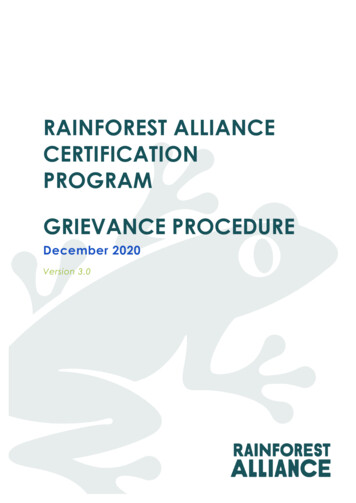
Transcription
CENTRAL EASTERN RAINFORESTRESERVES OF AUSTRALIA:A MONITORING STRATEGYGuy Chester1 and Sally Bushnell21EcoSustainAbility, CairnsSchool of Tropical Environment Studies and Geography, James Cook University, Townsville2Established and supported under theAustralian Cooperative Research Centres Program
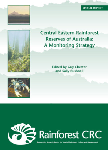
Department of Environment and Conservation (NSW) and Queensland Environmental Protection Agency.This work is copyright. Apart from any fair dealing for the purposes of private study, research, criticism or review, no part ofthis publication may be reproduced without written permission. Enquiries should be addressed to the CERRA ExecutiveOfficer, PO Box 361, Grafton NSW 2460, Australia.Published by the Cooperative Research Centre for Tropical Rainforest Ecology and Management (Rainforest CRC). Written bythe Rainforest CRC on contract to the Department of Environment and Conservation (NSW). Rainforest CRC logo and reportdesign copyright. Further copies may be requested from the Rainforest CRC, PO Box 6811 Cairns QLD 4870, Australia.The views expressed in this publication do not necessarily represent those of the NSW National Parks and Wildlife Service orthe Queensland Parks and Wildlife Service. While every effort has been made to ensure that the information is accurate at thetime of printing, neither agency or the Rainforest CRC accepts responsibility for any errors or omissions.ISBN 0 86443 746 3Published in April 2005This publication should be cited as:Chester, G. and Bushnell, S. (2005) Central Eastern Rainforest Reserves of Australia: A Monitoring Strategy. CooperativeResearch Centre for Tropical Rainforest Ecology and Management. Rainforest CRC, Cairns. (156 pp).This project was funded through the Bushcare Program of the Natural Heritage Trust Extension.Cover Images:Top Mt Warning, NSW ( Brad Cheers)Centre Antarctic Beech Cool Temperate Rainforest ( Queensland Environmental Protection Agency)Bottom Lamington Blue Spiny Crayfish Euastacus sulcatus (Steve Parish Queensland Environmental Protection Agency).
Central Eastern Rainforest Reserves of Australia Monitoring StrategyCONTENTSIntroduction . 1CERRA World Heritage Area . 1CERRA Geographic Extent and Regions. 2Background to Monitoring Strategy . 4Methodology and Team. 5CERRA World Heritage Values . 7What are the World Heritage Values?. 7Other Values . 10Threats to and Integrity of Values . 13Threats to World Heritage Values . 13Integrity. 15Current Research and Monitoring . 17Research Versus Monitoring . 17Research . 18Monitoring. 19Research and Monitoring Provisions of Species and Reserve Management Plans. 20Proposed Monitoring Approach for CERRA. 21Introduction. 21Overall Approach. 21Selection of Monitoring Indicators . 23Management Application. 25Spatial Approach . 26Monitoring Coordination . 26Indicator Identification and Evaluation. 26Proposed Monitoring Indicators . 43Summary of Essential Indicators. 43Detail for Priority Indicators . 44Statutory Protection. 44Management Plans . 46Management Resources . 48Status of Biodiversity Conservation. 50Vegetation Monitoring .52Forest Cover. 54Impacts of Climate Change . 56i
G. Chester and S. BushnellRufous Scrub-bird . 58Albert’s Lyrebird . 61Broad-toothed Rat . 63Eastern Bristlebird (northern) . 64Spotted-tailed Quoll. 66Stream Frogs – the Barred River Frogs . 68The Hastings River Mouse . 71Rufous Bettong. 73North Coast Leaf-tailed Gecko . 75Arboreal Fauna. 76Fire . 78Weed Control . 80Feral Animal Control. 81Bell Miner Associated Dieback. 82Visitation. 84Implementation of Monitoring Strategy . 87Gap Analysis . 87Strategies to Establish a CERRA Monitoring Program . 90References . 93Cited References. 93Further Information. 98Appendix One – Research and Monitoring in CERRA. 101Appendix Two – Other Monitoring Approaches. 127ii
Central Eastern Rainforest Reserves of Australia Monitoring StrategyINTRODUCTIONCERRA WORLD HERITAGE AREAThe World Heritage Central Eastern Rainforest Reserves of Australia (CERRA) represent themajor remaining areas of rainforest in southeast Queensland and northeast New SouthWales. They comprise National Parks, Nature Reserves and other Crown Reserves(CERRA, 2000). The property protects almost 50 individual reserves ranging in area from 11hectares to some 103,000 hectares. These reserves extend in a discontinuous arc fromBarrington Tops near Newcastle in New South Wales, to Mistake Mountains west ofBrisbane in Queensland, and cover a total area of 366,514 hectares (307,284 hectares inNew South Wales and 59,230 hectares in Queensland) (Hunter, 2003).CERRA was inscribed on the World Heritage List, first in 1986 and with extensions in 1994,as a site with outstanding universal significance in terms of its natural heritage. It satisfiedthree of the four possible criteria for the listing of a natural property, representing outstandingexamples of the major stages of Earth’s evolutionary history, ongoing geological andbiological processes and biological diversity.In nominating CERRA for the World Heritage listing, the Commonwealth Government onbehalf of the people of Australia accepted an obligation to ensure the identification,protection, conservation, rehabilitation and presentation of the property and its transmissionto future generations. In order to fulfil this obligation, some knowledge of the state of CERRA,over time, is required. Specifically, Section 2 of the World Heritage Convention’s OperationalGuidelines addresses reactive monitoring and periodic reporting. Paragraph 72 of theOperational Guidelines states:“It is the prime responsibility of the States Parties to put in place on-sitemonitoring arrangements as an integral component of day-to-day conservationand management of the sites. States Parties should do so in close collaborationwith the site managers or the agency with management authority. It is necessarythat every year the conditions of the property be recorded by the site manager orthe agency with management authority.”With the overarching aim to assess the overall application of the World Heritage Convention,as well as to assess whether the values for which properties were inscribed on the WorldHeritage List are maintained over time, the Commonwealth Government was ‘invited’ tosubmit a periodic report to the World Heritage Committee every six years (paragraph 73).The Commonwealth Government submitted a periodic report in 2003. Section 1, underCERRA in the property summaries, states, “the most significant factors affectingmanagement are the identification and monitoring of values and adequate management ofkey pressures. In particular, the ongoing commitment to coordinated monitoring and researchefforts across the property and development of systems for storage and distribution ofresource data and research results is of importance” (p. 32). Thus, “priorities for future actioninclude Develop a strategic approach to monitoring, both as a whole of property approachand in line with respective state agency management objectives” (p. 33). Australia as awhole is committed to the monitoring of its property’s World Heritage Values. Key nationalpriorities include “The further development and implementation of clear frameworks formonitoring World Heritage values and responding to identified pressures” (p. 28).Therefore, the development of a monitoring strategy for the CERRA World Heritage Area isof principle importance to both CERRA and Australia. With an adequately supported andstrategic monitoring program, the obligations of the World Heritage Convention may be1
G. Chester and S. Bushnellfulfilled, including the ability to report on CERRA’s World Heritage Values in the six-yearlyperiodic report next due in 2009. In addition, and more specifically, the extent, quality,timeliness and relevance of the information and knowledge base of CERRA will increase,leading to more informed decision making and better management of the CERRA WorldHeritage Area for the maintenance of integrity of its World Heritage Values.CERRA GEOGRAPHIC EXTENT AND REGIONSSites within CERRA generally fall into distinct groups, based either on geographic features ordisjunctions (Hunter, 2003). The following eight groups are recognised, summarised fromHunter (2003) and updated.Main Range GroupThe Main Range Group includes Main Range National Park, parts of several ForestReserves on the Main Range (Gilbert, Goomburra, Spicers Gap, Emu Vale, Gambubal,Teviot and Killarney), and the Wilsons Peak and Acacia Plateau sections of KoreelahNational Park in New South Wales.The predominant rainforest type is cool subtropical rainforest. Small stands of warmtemperate forest are also encompassed, and a significant feature of the area is the presenceof ‘temperate’ species in the open forests at high altitudes along the summit and westernslopes.Tweed Caldera GroupThe Tweed Caldera Group includes Mount Chinghee, Border Ranges, Springbrook andMount Warning National Parks, parts of Lamington, Wollumbin, Mebbin and NightcapNational Parks, Numinbah and Limpinwood Nature Reserves, a small section of the PalenCreek correctional facility and a Rabbit Board reserve.This group lies wholly, or in the case of Border Ranges National Park, largely on thelandforms created by the erosion of Tweed Shield Volcano. The remnant landforms of thisvolcano and the erosion caldera that has been carved out of the former massif are arguablythe central feature of CERRA. The area is regarded as one of the two major rainforestrefugia in continental Australia, the other being the Wet Tropics of northern Queensland. Thearea also represents a primary branch in the evolution of the Australian rainforests and has aGondwanan ancestry.The Focal Peak GroupThe Focal Peak Group includes parts of Mount Barney National Park, Tooloom, Toonumbar,Richmond Range, Mallanganee, Mount Clunie and Mount Nothofagus National Parks,Captains Creek Nature Reserve, Burnett Creek Forest Reserve, and a number of smallRabbit Board reserves.This group includes the rugged peaks, steep slopes and caldera valley of the centralcomplex of the Focal Shield Volcano. The area encompasses cool subtropical rainforest,cool temperate rainforest dominated by Nothofagus moorei and open forest.2
Central Eastern Rainforest Reserves of Australia Monitoring StrategyCoastal GroupThe Coastal Group comprises Iluka Nature Reserve. The reserve is only 136 hectares inextent, thus significantly smaller than the other CERRA sites. However, it is the only CERRAsite that samples littoral rainforest, which is a sub-set of the Gondwanic species that make upsubtropical rainforest. This rainforest is important for providing seasonal food resources for anumber of species.Gibraltar Range GroupThe Gibraltar Range Group includes parts of Washpool and Gibraltar Range National Parks.It is a block of rugged mountain country bounded by the Great Escarpment to the east andthe Demon Fault to the west. Gibraltar Range National Park is a high Plateau rising to 1200metres and extending north into Washpool National Park as a series of high ridges andplateaux dissected by steeply inclined valleys. This group is characterised by the diversity ofplant communities and the mosaic distribution of wet sclerophyll forests and rainforests.Warm temperate rainforest is the most extensive rainforest type within the area.New England GroupThe New England Group includes parts of Dorrigo, New England and Cunnawarra NationalParks and Mount Hyland Nature Reserve.Dorrigo National Park, New England National Park and Cunnawarra Nature Reserve lie onthe edge of the Great Escarpment, while Mount Hyland Nature Reserve rises from thenorthwestern side of the Dorrigo Plateau. One of the main centres of rainforest in New SouthWales at the time of European settlement, the wide altitudinal range and rugged topographyof the area results in the presence of rainforest types from warm subtropical to cooltemperate.Hastings-Macleay GroupThe Hastings-Macleay Group includes most of Oxley Wild Rivers and Werrikimbe NationalParks, part of Willi Willi National Park, and The Castles and Mount Seaview NatureReserves.The sites lie on the Great Escarpment. This group includes the last remaining stands ofrainforest within this area. These stands include areas of subtropical, dry, warm andtemperate rainforests. The area also includes some fine stands of wet sclerophyll forest, andswamp, grassland, heath and scrub communities.Barrington Tops GroupThe Barrington Tops Group comprises parts of Barrington Tops National Park.The site incorporates a high elevation plateau with steep dissected ridges and valley systemsfalling from it, with an altitude range from less than 200 metres to just under 1600 metres.The rainforests of this group have been relatively little affected by clearing. The major typespresent are subtropical and cool temperate, with small areas of warm temperate rainforest.The sites contain unsurpassed series of gradients between sclerophyll forests andrainforests in response to factors such as altitude, aspect, soil, rainfall and fire history.3
G. Chester and S. BushnellBACKGROUND TO MONITORING STRATEGYTo ultimately improve management outcomes of CERRA, the CERRA Strategic Overview forManagement recommends several streams of monitoring:i.The routine monitoring of indicators to allow regular reporting on the state of CERRAWorld Heritage Values;ii. The monitoring of management plans to assess their effectiveness; andiii. Monitoring to measure the success of rehabilitation programs.The key outcomes of this Monitoring Strategy are to meet the first of the monitoring streamsoutlined above. Specifically, it is a strategy for monitoring the state of the key CERRA WorldHeritage Values. Because the primary desired outcome of management is the long-termhealthy persistence of these key values, the emphasis of this Monitoring Strategy is onoutcome assessment, rather than management planning, input and processes.The Monitoring Strategy does not replace or duplicate existing monitoring programs, it willhowever, pull together and extend the effectiveness of existing monitoring and research. Itwill follow an adaptive design that allows the specifications for monitoring to be refined overtime, based on experience in implementing the program, assessing its results and feedbackfrom users.The Monitoring Strategy will have an initial lifespan of four years, with a review occurring in2008 during the preparation of the CERRA input for the 2009 Periodic Report. After this, thestrategy will be subject to ongoing review in an iterative process.ObjectivesThe objectives of the monitoring program described by the strategy are to: allow the trends in the state of the CERRA World Heritage Values to be monitored overtime; assess management effectiveness in relation to the conservation or ecological integrity ofthese values, and the abatement of their threats; and promote improved management effectiveness in CERRA through adaptive management.4
Central Eastern Rainforest Reserves of Australia Monitoring StrategyMETHODOLOGY AND TEAMScopeThe intention of the Monitoring Strategy is to translate the objectives for the monitoringprogram into rigorous quantitative and qualitative questions, which will be used to identify: which attributes of the World Heritage Values can and should be monitored; the features of those attributes to be measured, how often and where; how these features are to be consistently measured; and how these features are clearly linked to the broader objectives, so that any change in afeature can be interpreted as an indicator of change within the context of the relevantbroad questions.Overall ApproachThe priorities of the program are to identify realistic indicators, current research and surveywork that is relevant to monitoring, and the ‘gaps’ in current research work that need to befilled to ensure that all of the indicators are being adequately measured. Any existingmonitoring efforts that could achieve the objectives of the Monitoring Strategy with minimalchange will be identified along with any recommended changes. Special attention will also begiven to the identification of indicators required to measure the actual or potentialmanifestations of climate change on the CERRA World Heritage Values.The strategy will address the issue of consistent methodologies so that measurements takenin different places or by different agencies can be combined to describe the characteristics ofthe attribute across CERRA. Further more, it will address the estimates of variance of thefeatures being measured and measurement error over the relevant temporal and spatialscales so that status and trend information can be understood.In addition, the strategy will recognise the likely barriers to implementing and carrying out aneffective monitoring program. It is expected that there will be some lack of funding, time andtrained personnel, possibly even a lack of political interest and support. Therefore thestrategy endeavours to provide incentives and mechanisms in which these barriers can beovercome.AcknowledgmentsDuring the development of the CERRA Monitoring Strategy, the team liaised with a numberof stakeholders including the CERRA Executive Officer; CERRA Technical and ScientificAdvisory Committee (TSAC); staff of the management agencies in both New South Walesand Queensland; various researchers with activities, knowledge of and interests in CERRA;and key Rainforest CRC researchers. The team reviewed the current knowledge andmonitoring programs being undertaken for CERRA, as well as the current techniques andmonitoring strategies being applied to other protected areas and World Heritage Areas inorder to apply the best model for the CERRA situation.The authors would like to thank Professor Nigel Stork and Associate Professor PeterValentine for their comments and peer review of an earlier draft.5
Central Eastern Rainforest Reserves of Australia Monitoring StrategyCERRA WORLD HERITAGE VALUESWHAT ARE THE WORLD HERITAGE VALUES?World Heritage Values are those values directly related to the criteria for which an area isincluded on the World Heritage List. The CERRA was inscribed on the World Heritage Listfor outstanding universal values:Natural Criterion 1 – A Record of the Past“Outstanding examples representing the major stages of the earth's evolutionary history.”The World Heritage Values of the property related to this criterion are as follows.CERRA World Heritage Area rainforests are an outstanding example of ecosystems and taxafrom which modern biota are derived. These rainforests are exceptionally rich in primitiveand relict species, many of which are similar to fossils from Gondwana.The CERRA World Heritage Area includes an outstanding range of ecosystems and taxa,which demonstrate the origins and rise to dominance of cold-adapted/dry-adapted flora.The CERRA preserves outstanding examples of ecosystems and taxa from which modernbiota are derived, including some of the oldest elements of the world's ferns from theCarboniferous period, one of the most significant centres of survival for Araucarians, anoutstanding record of Angiosperms, an outstanding number of the oldest lineages of theCorvida (one of the two major groups of true songbirds that evolved in the Late Cretaceous),and outstanding examples of other relict vertebrate and invertebrate fauna from ancientlineages linked to the break-up of Gondwana. World Heritage Values include: Rainforests, which are exceptionally rich in primitive and relict species and many of whichare similar to fossils from Gondwana; Subtropical rainforest habitat; Warm temperate rainforest habitat; Ancient ferns and tree ferns; Conifers (e.g. hoop pine) and cycads; Primitive groups within Magnoliales and Laurales (e.g. pepper bushes, sassafras,Trimenia, Wilkiea, Cryptocarya, Litsea); Primitive groups within Rosidae and Dillenidae (e.g. coachwood, Antarctic Beech,Eucryphia jinksii, turnipwood, Pittosporum, most common in warm temperate andsubtropical rainforest types); Primitive group of Corvida (such as lyrebirds, rufous scrub-bird, bowerbirds and treecreepers); Other birds dating from Gondwana (e.g. logrunner, thornbills, scrubwrens andgerygones); Frogs in the families Myobatrahidae and Hylidae; Reptiles such as chelid turtles, leaf-tailed gecko and angle-headed dragon; Monotremes and marsupials; and7
G. Chester and S. Bushnell Invertebrate fauna with origins in Gondwana, including fresh-water crays, land snails,velvet worms, mygalomorph spiders, flightless carabid beetles, bird-wing butterfly andglow-worms.World Heritage Values also include ecosystems and taxa which demonstrate the origins andrise to dominance of cold-adapted/dry-adapted flora, including: Cool temperate rainforest habitat; Dry rainforest habitat; and Plant species in the families Myrtaceae, Casuarinaceae and Proteaceae.Natural Criterion 2 – A Window to the Future“Outstanding examples representing significant ongoing geological processes, biologicalevolution and man's interaction with his natural environment.”Statements of the World Heritage Values relevant to this criterion are:CERRA World Heritage Area includes outstanding geological features associated with theTweed Shield, including its size, age and erosional landforms.CERRA World Heritage Area includes significant centres of endemism where ongoingevolution of flora and fauna species is taking place.The CERRA provides outstanding examples of ongoing geological processes associatedwith Tertiary volcanic activity, and of biological evolution. World Heritage Values include: The caldera of the Tweed Shield Volcano is considered one of the best preservederosion caldera in the world and is notable for its size, its age (20 million years), and forthe presence of a prominent central mountain mass with all three stages of the erosion ofshield volcanoes (the planeze, residual and skeletal stages); Centres of endemism where ongoing evolution is taking place; Flora and fauna of low dispersal capability that occur in more than one isolated pocket ofthe CERRA; Plant taxa that show evidence of relatively recent evolution, including: 8 genera in Southern Hemisphere families (e.g. Winteraceae, Monimiaceae andLauraceae in the Magnolidae, Proteaceae, Cunoniaceae, Euphorbiaceae,Escalloniaceae, Davidsoniaceae Pittosporaceae, Myrtaceae and Sapindaceae in theRosidae and, Elaeocarpaceae, Sterculiaceae and Ebenaceae in the Dillenidae); and monotypic endemic families (e.g. Akaniaceae and Petermanniaceae);Animal taxa that show evidence of relatively recent evolution, including: three species of frogs in the myobatrachid genus Pseudophyrne believed to havediverged in the Pliocene; species of frogs in the relict genus Philoria (also known as Kyarranus) and the Litoriapearsoniana/ L. phyllochroa complex; reptiles such as Eulamprus spp.; and invertebrates such as snails, earthworms, crays, velvet worms and carabid beetles,including taxa that show overlap and intergradation of different faunal elements (e.g.ants and dung beetles).
Central Eastern Rainforest Reserves of Australia Monitoring StrategyCriterion 4 – Hotspots of Biodiversity“Contain the most important and significant habitats where threatened species of plants andanimals of outstanding universal value from the point of view of science and conservation stillsurvive.”The World Heritage Value relevant to this criterion is:CERRA World Heritage Area includes the principal habitats of a large number of threatenedspecies of plants and animals. These species are of outstanding universal value from thepoint of view of science and conservation, including relict and primitive taxa.The ecosystems of the CERRA contain significant and important natural habitats species ofconservation significance, particularly associated with rainforest which once covered much ofthe continent of Australia and is now restricted to archipelagos of small areas of rainforestisolated largely by sclerophyll vegetation and cleared land. The World Heritage Valuesinclude: Habitats associated with: subtropical rainforest; wet sclerophyll forest; montane heathlands; rocky outcrops; and ecotones between rainforest and sclerophyll communities; Plant taxa of conservation significance (more than 200 plant taxa, particularly in thefamilies Proteaceae, Myrtaceae and Euphorbiaceae and including species ofCryptocarya, Tasmannia and Endiandra); Spe
Chester, G. and Bushnell, S. (2005) Central Eastern Rainforest Reserves of Australia: A Monitoring Strategy. Cooperative Research Centre for Tropical Rainforest Ecology and Management. Rainforest CRC, Cairns. (156 pp). This project was funded through the Bushcare Program of the Natural Heritage Trust Extension. Cover Images: