Transcription
CITY OF MONTEBELLOPlanning and Community Development Department1600 W. Beverly BoulevardMontebello, CA 90640INITIAL STUDY OF ENVIRONMENTAL IMPACTSENVIRONMENTAL CHECKLIST FORM1. Project Title:121 E. Madison Avenue2. Lead Agency Name and Address:City of MontebelloPlanning and Community Development Department1600 W. Beverly BoulevardMontebello, CA 906403. Contact Person and Phone Number:Ms. Josephine PhamCity of Montebello Planning Staff(323) 887-12004. Project Location:121 E. Madison AvenueMontebello, CA 906405. Project Sponsor’s Name and Address:Mr. Ken BradburyMontebello Land & Water Company344 E. Madison Avenue6. General Plan Designation:Low Density Residential7. Zoning:R-2 (Single-Family Residential)8. Description of Project:Project LocationThe Project site is located within the City of Montebello (City) in Los Angeles County (see Figure 1,Regional Location, an d Figure 2, Aerial Photograph). The 6 ,500-square-foot property is loca ted a t121 E. Ma dison Ave nue (As sessor’s I dentification Number [AIN] 6 346-018-012), so uthwest of th eintersection of E. Ma dison Ave nue and N. Po plar Avenue. S urrounding land us es i ncludesingle-family r esidences o n all s ides, w ith additional mor e di stant us es incl uding c ommercial usesand a hospital located to the north, an elementary school to the n orthwest, and a ch urch and the RioHondo Channel to the east.1
SurroundingLandU The Project site is currently a vacant dirt lot located at the southwest corner of E. Madison Avenue and N.s Poplar Avenue, and is bordered by residential development on all sides.Existing Project Site ConditionsThe Proje ct site was p reviously developed with a 1 920s-era single-family ho use with detachedgarage on a residential lot that measures ap proximately 130 fe et l ong by 5 0 fe et w ide. The smalldetached garage was located to the rear of the l ot (southern portion) with the driveway located off N.Poplar Ave nue. Base d on i nput from U nderground Ser vice Alert, the Pr oject site’ s exi sting sew erservice is fr om E. Madi son Aven ue an d water serv ice is from ex isting faci lities a long N. P oplarAvenue. Ele ctrical facil ities ar e po le-mounted over head po wer li nes, an d a larg e storm drai n catchbasin is located along the east side of the lot. As o f September 26, 2019, all existing buildings andimprovements were demolished, and the site is currently a vacant dirt lot (see photo above). Severalmature street trees are located within the parkway along N. Poplar Avenue.Description of the Proposed ProjectThe Pr oposed Proj ect inv olves the installation of a n ew well, Wel l No. 15, i n a ddition to a bac kuppower generator, a tra nsformer, and asso ciated imp rovements and appurtenances. We ll pu mps,valves, pipes, electrical equipment, and a Southern California Edison (SCE) electrical meter would beconstructed i n an a pproximately 1 5-foot by 55-fo ot concrete b lock stru cture i n th e cent er of th eProject site (i.e., the main well building), as sho wn in Figure 3, Site Plan. The proposed structureswould be designed not only to minimize noise and provide shelter and security for well equipment, butalso to mimic residential dev elopment in terms of scale, architect ure, building mater ials, setbacks,and other design features. Well No. 15 would connect to an existing 18-inch pipeline located north ofthe Project site under E. Ma dison Avenue. A flow met er vault and a 6- to 8-feet d eep settling basin(waste sand trap) would be located on the east side of the main well building. In the southwest cornerof the P roject site, a n a pproximately 20-foot by 2 8-foot sou nd atte nuation str ucture wo uld b econstructed to house the generator. Additionally, an SCE service transformer would be located in the2
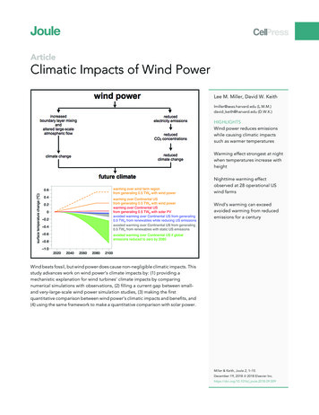
a"!121 E. Madison AvenuePALMDALEñAACTON!!!!!! !!?ß!!!! !!!!!! !!!!!!!!!!!HESPERIA!!!! !LOSANGELESSANCOUBERNNTYARDINOCOUNTY!!!!!!!! !! !!!!!!!!!! !!!!!!!!! !! !!! !!!! !!!!!!!!!!!!!!!!!!!!!!!!!!!!!! !! ! !!!!! !!!aM!!! !!!!! !! !!!!! !! !!!!!!!!!!ou ?!!!!!!ai!!!! !!!!!!!!!!!!!!!!!!! !!!!!!!!! !! !! !!!!!!!!! !!!!ntLAKEELSINOREns!!!!! !!!!!!!!!! a"!!!MISSIONVIEJO!(h&%LakeElsinore!! ?CanyonLake! !!!!!!! !! !!! !!!!!LAGUNABEACH! ?!!!!!!!!!!!!!!! !!!!!!!!!!!!!!!!!!!! !!!!!!! ! !! !!!!!!!!!!!!!!! !! !!! !!!!!!!!!!!!!!!Regional Location!!!!! !!! !! !!!! !!!!!!! !!!!!!!!!!!!!! !!!!!!!! !!!!!!!!K!!!! !Source: Base Map Layers (ESRI, 2013)!!!!!!!!!!!!!!!!!!!! !!!!10 Miles!!!! !!!!!!!!! !!!!!!!!! !O'NeillLakeFigure 1!!!!!!!!!!!! !CAMPPENDLETON!!!!!!! !!!!!!!! !SANTACATALINAISLAND!!!!!! !!! "!!!!!!! !! !!!!!!0SANCLEMENTERIVDIE ERSIDGOECO COUNUNTY TY!!!!! !!!!!!SAN!!!!!!Ocean! !Pacific!!!!!!!!!!An! !!!a! !!!!!!!!!! ! !!!!!! !!ÎAnt a"!!!!!!!!!!Sa!!!! !!!!!!!!NEWPORTBEACH!!!AÝ? !s "IRVINE(l&%!!! !!! !SANTAANAHUNTINGTONBEACH!!!!!!! !!!!!!!!!!!!!! !!!!!!!!!!! !!!!!!!! !!! ! !!! !!!!!!!! !! !!! !! ! ! !!! ! !!!!!!! !!!(l&%!! ! !!!!! !IrvineLake(h&%LakeMathewsCORONATYUNO TYE C UNOSIDER E CRIV NGAOR!!!!!?ì! !! !!!! !WESTMINSTERÆ?!! !ÆANAHEIM?!!LONGBEACH!!!! !!!Æ?!!I:\PROJECTS\A\AKM\AKM-03 MontebelloWell\Map\ISMND\Fig1 Regional.mxd AKM-03 6/8/2020 - RK!!!!!!(l&%!!!!!!! !!!!!?ÔRANCHOPALOSVERDES!! !u?(o&%!!RIVERSIDE!!! !! !TORRANCE!!!!! !NORWALK a"!LAHABRABUENAPARK!! !! !!!! !!!!! !!!!!!! WNEYns!!!! "!!!!!(h&% ̀"!POMONAz?!!! !!!?åt ai!! !! ?!un!! !! !Project Site! !INGLEWOODWESTCOVINAMo?ø SAN BERNARDINO ?ONTARIOno!!!! !!! ! ! ! !!!! !! !!!! ! !!!! ! ̀"!PuddingstoneReservoirr di!!! !!!! !! !! !HILLS(?l&% !(e&%!!%(g&(o&% ̀"!!!!!!!!!! !!! ! !!!!!! !! !!!!!!!!PASADENA!! !!GLENDALEAíÆI? BEVERLY HOLLYWOOD!rn a!!!!!ñ San Be Aa"!! !!! !!MorrisReservoirsSilverwoodLake!!!BURBANK!!!!!!! "mA!!(g&%San GabrielReservoir!!!San Gab r ie l Mo u n t a in! !!! !HansenLake!!!? !! !åA!!ñA!!!!!!!!!VICTORVILLE?å
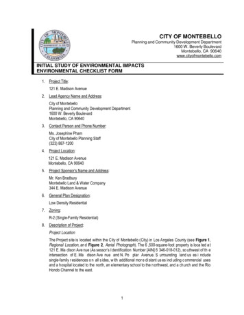
Aveg AvePoplarHardinWilber Pl121 E. Madison AvenueN 2n dStE H arding AveLndisonWilbW Maer PlN Poplar AveN 1stStMaidenAveProject Site0montSqE FremE ClevelandAveN Poplar Aved AveStW Clevelanont SqN 1stI:\PROJECTS\A\AKM\AKM-03 MontebelloWell\Map\ISMND\Fig2 Aerial.mxd AKM-03 6/8/2020 - RKW Fre200 FeetKSource: Aerial (Esri 2018)Aerial PhotographFigure 2
I:\PROJECTS\A\AKM\AKM-03 MontebelloWell\Map\ISMND\Fig3 SitePlan.indd AKM-03 06/08/20 -RK121 E. Madison AvenueSource: AKM 2020Site PlanFigure 3
southeast comer of the lot. The Proposed Project would contain lighting for security and maintenancepurposes. The proposed lighting would conform to the California Building Standards Code, Title 24,and the lighting would be similar to the existing lighting surrounding the Project site.The P roposed Proj ect also involves v arious site im provements. A 3 -foot-high wr ought ir on f encewould be constructed along the perimeter of the northern portion of t he site. The remaining Projectsite p erimeter wo uld inc lude a 6-fo ot bl ock wall a nd a ccess gat es o n E. Madis on Ave nue a nd N .Poplar Avenue. The existing driveway in the southeast corner of the site would be demolished andreplaced w ith a n ew driveway occ urring im mediately north of t he existing driveway. This drivewaywould provide site access from N. Popl ar Avenue controlled by a 2 0-foot sliding gate at the prop ertyline immediately west of the existing sidewalk easement. The second concrete driveway is proposedalong the northern boundary of the site off E. Madison Avenue, site access from which would also begate-controlled. Utility c onnections would include water lines on the north, sewer on the east, and apump-to-waste line to the existing catch basin on N. Poplar Avenue.The proposed new well would operate continuously to provide additional domestic water supplies tocustomers within the Montebello Land & Wat er Company service area. The Proposed Project wouldinvolve w eekly visits to the well site to c onduct ro utine testi ng a nd mai ntenance activ ities ty picallyinvolving one service vehicle and technician per visit. The emergency generator would only operateon an as-needed basis to provide water pressure during power outage events. The generator wouldbe tested monthly, during normal business hours, to ensure that it is in good operating condition. Thiswould involve the operation of the generator for approximately 10 minutes on a monthly basis.Surrounding Land Uses:Zoning (Montebello Municipal Code [MMC] Chapter 17.04)North:South:East:West:R-2 (Two-Family Residential)R-2 (Two-Family Residential)R-1 (Single-Family Residential)R-2 (Two-Family Residential)Land Use (City of Montebello 1973b)North:South:East:West:RES (Residential)RES (Residential)RES (Residential)RES (Residential)9. Other agencies whose approval is required (e.g., permits, financing approval, or participationagreement):PROJECT SITE3
Environmental Factors Potentially Affected:The environmental factors che cked belo w would b e po tentially affected by this p roject, involving at least oneimpact that is a “Potentially Significant Impact” as indicated by the checklist on the following pages.AesthetBiicsological ResourcesAgriculture and ForestryResourcesAirQualityCultural ResourcesEnergyGeology and SoilsGreenhouse Gas EmissionsHazardous and HazardousMaterialsHydrology and Water QualityLand Use and PlanningMineral ResourcesNoisePopulation and HousingPublic ServicesTransportationTribal Cultural ResourcesWildfireMandatory Findings ofSignificanceRecreationUtilities and Service Systems4
Evaluation of Environmental Impacts:1)A brief explanation is re quired for all answers except “No Impact” a nswers tha t are adequatelysupported by the information sources a lead agency cites in the parentheses following each question. A“No Imp act” answer is adequately sup ported if the referenced in formation sou rces show that theimpact simply does not apply to projects like th e one involved (e .g., the project falls outside a faultrupture zone). A “No Impact” answer should b e explained where it is b ased on project-specificfactors as well as general standa rds (e.g., the project will not expose se nsitive re ceptors topollutants, based on a project-specific screening analysis).2)All answers m ust ta ke account of the whole action involved, in cluding off-sit e as well as on-site,cumulative as we ll as p roject-level, in direct as well a s direct, and construction a s well as operationalimpacts.3)“Potentially Significant Impact” is appropriate i f th ere is substantial evidence that a n effect issignificant. If there are one or more “Potentially Significant Impa ct” e ntries when the determination ismade, an Environmental Impact Report (EIR) is required.4)“Potentially Significant Unless Miti gation Incorporated” applies w here t he in corporation o f mitigationmeasures has red uced a n effe ct from “Potentially Significant Impact” to a “Less than SignificantImpact.” Th e lead agency must describe the mitigation measures, and briefly explain how they reducethe effect to a less than significant level.5)Earlier analyses may be used where, pursuant to t he tie ring, Program EIR or other CEQAprocess, a n effect ha s bee n adequately analyzed in an ea rlier EIR or Negative Declaration. Section15063(c)(3)(D).6)Lead agencies ar e encouraged to in corporate into th e che cklist references to in formation sources forpotential i mpacts ( e.g., general p lans, zoning ordinances). Reference to a previously prepared oroutside d ocument should, where a ppropriate, include a re ference to the page or pages where thestatement is sub stantiated. A r eferences list should be attached and other sources used orindividuals contacted should be cited in the discussion.6
PotentiallyLess ThanSignificantIssues (and Supporting Information Sources):SignificantNo ImpactUnless MitigationImpactIncorporatedI. AESTHETICS. Except as provided in Public Resources Code Section 21099, would the project:a. Have a substantial adverse effect on a scenic vista?Xb. Substantially damage scenic resources, including, butnot limite d t o trees, rock outcro ppings, a nd hist oricXbuildings within a state scenic highway?c. Substantially degrade the existing visual character orquality of public views of the site and its surroundings?(Public views are those that are experienced fromXpublicly accessible vantage point). If the project is inan urbanized area, would the project conflict withapplicable zoning and other regulations governingscenic quality?d. Create a new source of substantial light or glare t hatwould adversely affect day or nighttime views in theXarea?Discussion:a. Scenic vistas are generally defined as public viewpoints that provide expansive or notable views of a highly valuedlandscape and are typically identified in planning documents, such as a community plan, but can also include locally knownareas or locations where high-quality public views are available. The Conservation Element of the City of MontebelloGeneral Plan does not identify the Project site as a scenic vista (City 1975). Additionally, the Project site is not in a locationwhere high-quality public views are available. Therefore, the Proposed Project would not have a substantial adverse effecton a scenic vista. No impacts would occur.PotentiallySignificantImpactb.There are no officially designated state scenic highways in the vicinity of the Project site. The nearest state scenic highwayis State Route (SR) 2, which is approximately 15 miles north of the Project site. Additionally, the Project site is not locatednear a scenic highway identified in the Scenic Highway Element of the City’s General Plan (City 1975). Therefore, theProposed Project would not damage scenic resources within a state scenic highway. No impacts would not occur.c.The Proposed Project involves adding a new water well to a previously developed single-family residential lot in a highlydeveloped and urbanized area. The new well facility would be located in an area immediately surrounded by residentialuses, with commercial and industrial uses located approximately one-quarter mile from the site. The Proposed Projectwould result in a change in the existing visual character of the site from a vacant, undeveloped parcel to a parcel developedwith a water well housed within structures that are designed not only to minimize noise and provide shelter and security forwell equipment, but also to mimic residential development in terms of scale, architecture, building materials, setbacks, andother design features. This facility would not be visually inconsistent with the surrounding residential development.Therefore, the Proposed Project would not substantially degrade the existing visual character or quality of public views onthe site and its surroundings. Impacts in this regard would be less than significant.d.The Project site is located in an area that is developed with primarily residential uses. The existing light conditions in theProject area include internal and external residential lighting, and nearby street lighting. The Proposed Project wouldcontain lighting for security and maintenance purposes. The proposed lighting would conform to the California BuildingStandards Code, Title 24, and the lighting would be similar to the existing lighting surrounding the Project site. Therefore,impacts related to lighting would be less than significant.The Proposed Project would not introduce a substantial source of glare to the Project site that would affect views in thearea because the Proposed Project would construct structures using typical building materials, which would not createsubstantial daytime glare. Sources of daytime glare would include cars within the Project site; however, the ProposedProject would not include a substantial number of cars visiting the Project site. As such, impacts would be less thansignificant.7
Issues (and Supporting Information gnificantUnless MitigationIncorporatedLess ThanSignificantImpactNo ImpactII.a.AGRICULTURE RESOURCES. Would the project:Convert Prime Farmland, Unique Farmland, orFarmland of Statewide Importance (Farmland), asXshown on the maps prepared pursuant to theFarmland Mapping and Monitoring Program of theCalifornia Resources Agency, to non-agricultural use?b. Conflict with existing zoning for agricultural use, or aXWilliamson Act contract?c. Conflict with existing zoning for, or cause rezoning of,forest land (as defined in Public Resources CodeSection 12220[g]), timberland (as defined by PublicXResources Code Section 4526), or timberland zonedTimberland Production (as defined by GovernmentCode Section 5110[g])?d. Result in the loss of forest land or conversion of forestXland to non-forest use?e. Involve other changes in the existing environmentwhich, due to their location or nature, could result inXconversion of Farmland, to non-agricultural use orconversion of forest land to non-forest use?Discussion:a. The Project site was not surveyed as part of the Farmland Mapping and Monitoring Program due to its location in ahighly urbanized region of Los Angeles County (California Division of Land Resources Protection, 2010). The ProposedProject would not convert Prime Farmland, or Farmland of Statewide Importance as shown on the maps preparedpursuant to the Farmland Mapping and Monitoring Program of the California Resources Agency. No impact wouldoccur.b. The Project site is zoned for residential uses and is not in a Williamson Act contract. No impact would occur.c-e. The Project site is zoned for residential uses and is not zoned for forest land or timberland. The Project site issurrounded by residential and commercial development, and other highly developed land. The site is not locatednear any forest land and would not result in the conversion of farmland or forest land to another use. No impactwould occur.Issues (and Supporting Information Sources):PotentiallySignificantImpactIII. AIR QUALITY. Would the project:a. Conflict with or obstruct implementation of theapplicable air quality plan?b. Result in a cumulat ively considerable net increa se ofany criteria pollutant for which the pro ject reg ion isnon-attainment under an applicable federa l or stateambient air quality standard?c. Expose sensitive receptors to substantial pollutantconcentrations?d. Result in other emissions (such as those leading toodors) adversely affecting a substantial number ofpeople?PotentiallySignificantUnless MitigationIncorporatedLess ThanSignificantImpactXXXX8No Impact
Discussion:The air quality setting, regulatory framework, analysi s methodology and impacts were analyzed in a technical letter report whic his included as Appendix A to th is initial study (HELIX 2020a). T he results of the impact analysi s in the report are summari zedbelow.a. On March 3, 2017, the South Coast Air Quality Management District (SCAQMD) adopted the 2016 Air Quality ManagementPlans (AQMP). The plan seeks to achieve multiple goals in partnership with other entities promoting reductions in criteriapollutant, greenhouse gases, and toxic risk, as well as efficiencies in energy use, transportation, and goods movement(SCAQMD 2017). The AQMP is incorporated into the State Implementation Plan, which is subsequently submitted to the USEnvironmental Protection Agency (USEPA). The Southern California Association of Governments (SCAG) has prepared theRegional Transportation Plan/Sustainable Communities Strategy (RTP/SCS), a long-range transportation plan that usesgrowth forecasts to project trends out over a 20-year period to identify regional transportation strategies to address mobilityneeds. These growth forecasts form the basis for the land use and transportation control portions of the AQMP. Both theRTP/SCS and AQMP are based, in part, on projections originating with County and City General Plans.As discussed in Item III b., below, the Proposed Project would not generate short-term or long-term emissions that couldpotentially cause an increase in the frequency or severity of existing air quality violations; cause or contribute to new violations;or delay timely attainment of air quality standards. The proposed project would install and operate a water well and would notresult in population or employment increases in the region, therefore, it would not exceed the growth projection assumptions inthe AQMP. In addition, the proposed project would be located less than 0.2 mile from the Montebello Land and WaterCompany yard and maintenance trips would result in minimal vehicle miles traveled (VMT). Because the Proposed Project isconsistent with the growth and vehicle miles travelled assumptions used in developing the AQMP, pursuant to SCAQMDguidelines, the proposed project is considered consistent with the region’s AQMP. Therefore, the Proposed Project would notconflict with or obstruct implementation of the applicable air quality plan, and the impact would be less than significant.b. The Proposed Project is located within the South Coast Air Basin (SCAB). The SCAB is currently in nonattainment for federaland/or state ozone (O3), respirable particulate matter (PM10) and fine particulate matter (PM2.5) standards. Concentrations of allother pollutants, including volatile organic compounds (VOCs), oxides of nitrogen (NOX), carbon monoxide (CO), and sulfurdioxide (SO2), meet state and federal standards. The SCAQMD has established significance thresholds to assess the regionaland localized impacts of project-related air pollutant emissions. A project with daily emission rates, risk values, orconcentrations below these thresholds is generally considered to have a less than significant effect on air quality.The Propo sed Project’s construction and ope rational emissions we re calculated us ing the California Emission s E stimatorModel (CalEEMod), Version 201 6.3.2. Project construction is anticipated to last approximately 12 months and was assumedfor conse rvative modeling purp oses to com mence as early a s September 2020. The Proposed Project would result inpollutant emissions from the use of construction equipment, architectural coating (e.g., painting), and worker and constructionvehicles traveling to and from the Pr oject site. As sho wn in Table 1, Maximum Daily Construction Emissions, the ProposedProject’s construction emissions would not exceed SCAQMD thresholds and would not result in a cumulatively considerablenet increase of any criteria pollutant.Table 1MAXIMUM DAILY CONSTRUCTION EMISSIONSPhaseSite PreparationDrillingBuilding Construction/EquippingPavingArchitectural CoatingMaximum Daily EmissionsSCAQMD ThresholdsSignificant 9.2100NoPollutant Emissions (lbs/day)COSO2PM103.0 0.00.28.4 0.00.67.0 0.00.67.8 0.00.62.2 0.00.28.4 urce: HELIX, 2020a; CalEEMod; SCAQMD 2019lbs/day pounds per day; VOC volatile organic gas; NOX nitrogen oxides; CO carbon monoxide; SO2 sulfur dioxide;PM10 respirable particulate matter with a diameter of 10 microns or less; PM2.5 fine particulate matter with a diameter9
of 2.5 microns or less; SCAQMD South Coast Air Quality Management DistrictLong-term ope ration of the Proposed Project would result in pollutant emissions from: the u se of landscape equipment,paint, and cleaning/degreasing p roducts for maintenance; up to two maintenance vehicle trips per day t raveling between theProject site and the Montebello Land and Water Company ya rd, approximately 0.2 mile each way; and operation of a 750kilowatt (kW), compressed natural gas (CNG) po wered, emergency backup generator up to six ho urs per year. As shown inTable 2, Maximum Daily Operat ional Em issions, the Proposed Project’s operati onal criteria pollutant and ozone precursoremissions would not exceed the SCAQMD thresholds and would not result in a cumulatively considerable net increase of anycriteria pollutant.Table 2MAXIMUM DAILY OPERATIONAL EMISSIONSSourceAreaMobileStationaryMaximum Daily EmissionsSCAQMD ThresholdsSignificant Impact?VOC 0.1 0.15.45.475NoNOX 0.1 0.10.40.4100NoPollutant Emissions (lbs/day)COSO2PM10 0.1 0.1 0.1 0.1 0.1 0.114.0 0.1 0.114.0 0.1 0.1550150150NoNoNoPM2.5 0.1 0.1 0.1 0.155NoSource: HELIX, 2020a; CalEEMod; SCAQMD 2019lbs/day pounds per day; VOC volatile organic gas; NOX nitrogen oxides; CO carbon monoxide; SO2 sulfur dioxide;PM10 respirable particulate matter with a diameter of 10 microns or less; PM2.5 fine particulate matter with a diameterof 2.5 microns or less; SCAQMD South Coast Air Quality Management DistrictAs shown in the tables above, the Proposed Project’s construction and operational pollutant emissions would not exceed theSCAQMD thresholds and would not result in a cumulatively considerable net increa se of an y criteria pollutant. The impactwould be less than significant.c. The localized effects from the on-site portion of daily construction emissions were evaluated at sensitive receptor locationspotentially impacted by the Proposed Project according to the SCAQMD’s Localized Significance Thresholds (LSTs) method(SCAQMD 2009). LSTs represent the maximum emissions from a project that will not cause or contribute to an exceedance ofthe most stringent applicable federal or state ambient air quality standard; they are developed based on the ambientconcentrations of that pollutant for each source receptor area (SRA). If a project exceeds the LST look up values, then theSCAQMD recommends that project-specific localized air quality modeling be performed. The Proposed Project is in SRA 11,South San Gabriel Valley, and sensitive receptors are located within 25 meters (82 feet) south and west of the 6,500-squarefoot (0.15-acre) Project site. As shown in Table 3, Maximum Localized Daily Construction Emissions, the maximum daily onsite construction emissions would not exceed the SCAQMD LSTs, and project-specific localized air quality modeling would notbe required.Table 3MAXIMUM LOCALIZED DAILY CONSTRUCTION EMISSIONSPhaseSite PreparationDrillingBuilding Construction/EquippingPavingArchitectural CoatingMaximum Daily EmissionsSCAQMD LSTSignificant Impact?NOX2.48.98.06.71.58.983No10Pollutant Emissions 46735NoNoPM2.50.10.40.40.30.10.44No
Source: HELIX, 2020a; CalEEMod; SCAQMD 2009lbs/day pounds per day; NOX nitrogen oxides; CO carbon monoxide; PM10 respirable particulate matter with adiameter of 10 microns or less; PM2.5 fine particulate matter with a diameter of 2.5 microns or less;SCAQMD South Coast Air Quality Management District; LST Localized Significance ThresholdLocalized on-site operational emissions sou rces would be limited to exhau st form the e mergency backup gene rator, whichwould only occur during emergency use (power loss) or for routine testing and maintenance up to 10 minutes per month andwould not result in substantial localized concentrations of pollutants.Construction of the Proposed Project would result in the use of heavy-duty const ruction e quipment, haul trucks, an dconstruction wo rker vehicles. These vehicles a nd equipment could generate diesel particulate matter (DPM), which isclassified as a toxic air contaminant (TAC). Generation of DPM from construction projects typically occurs in a localized area(e.g., near locati ons with multiple pieces of hea vy construction equipment working in close proximity) for a short period oftime. Because construction acti vities and subse quent emissions vary du ring the phase of construction, the constructionrelated emissions to which nearby receptors are exposed to would also va ry throughout the con struction period. The tota lproject construction duration would be appro ximately 12 mont hs. Du ring the construction period, the only a nticipatedconstruction equipment use that would not be sp oradic would be drilling the well, which is anticip ated to last approximatelyone month (22 workdays). Con sidering the small size of the Proposed P roject and the short duration of inte nse u se o fconstruction eq uipment, const ruction of the Proposed Project would not expo se se nsitive receptors to sub stantial DPMconcentrations. Localized on-site operational exhaust particulate matter sources would be limited to exhaust from the naturalgas-powered e mergency ba ckup generator, wh ich would only occu r for te sting and maintenance (up to 10 minutes permonth), or during incidental eme rgency operation, and would no t result in sub stantial localized concentrations of particulatematter.Long-term operation of the Pro posed Proje ct would result in minimal vehicle tri ps (up to 2 per day fo r mainten ance) andwould not contribute to localized con centrations of CO (i.e., hotspots). The refore, the Propo sed Project would not exposesensitive receptors to substantial pollutant concentrations, and the impact would be less than significant.d. The Proposed Project could produce odors during proposed construction activities resulting from heavy diesel equipmentexhaust and application of asphalt; however, standard construction practices would minimize the odor emissions and theirassociated impacts. Odors emitted during construction would be temporary, short-term, and intermittent in nature, would ceaseupon the completion of the respective phase of construction, and would be similar to common odors from vehicles in urbanenvironments. Long-term operation of the Proposed Project would not be a significant source of odors. Therefore, theProposed Project would not result in other emissions of odors adversely affecting a substantial number of people, and theimpact would be less than significant.Issues (and Supporting Information Sources):PotentiallySignificantImpactIV. BIOLOGICAL RESOURCES. Would the project:a. Have a substantial adverse effect, either directly orthrough habitat modifications, on any speciesidentified as a candidate, sensitive, or special statusspecies in local or regional plans, policies, o
INITIAL STUDY OF ENVIRONMENTAL IMPACTS ENVIRONMENTAL CHECKLIST FORM . 1