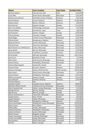
Transcription
Skills Development SeriesBasicHighwayPlanReading
Basic Highway Plan ReadingBasic HighwayPlan ReadingReproduction of any or all portions of this Manual is prohibited without the written consent ofthe Georgia Department of Transportation.developed in conjunction withRevised October 1, 2020
Table of ContentsList of Figures . viForward . ixA Note on Safety . xNuts and Bolts of the Course . xiChapter 1Beginning to Read Plans . 1General Information . 1Requirements and Specifications . 1What Part of The Contract Applies?. 1In Case of A Discrepancy, Certain Parts of The Contract Govern Over Others . 1Sheet Order . 1Errors or Omissions . 2Cover Sheet . 2Description . 4Project Location Sketch . 5Layout View . 5Sheet Identification . 6Plans Revised and Plans Completed . 8Scale. 8Project Length . 10Cover Sheet Questions . 10Design Data . 10Chapter 2Index and Revision Summary Sheet . 11Index . 11Revision Summary Sheet . 11Chapter 3Typical Sections . 13Introduction to Typical Sections . 13Horizontal Distance . 14Chapter 4Summary & Detailed Estimate Quantities . 15Summary of Quantities . 15(Continued on page ii)Table of Contentsi
Drainage Summary .15Detailed Estimate .16Chapter 5Views .19Introduction to Views .19Longitudinal Cross Section .19Cross Section .20Profile View.20Chapter 6Stationing, Symbols, And Abbreviations .23Stationing .23Half Stations .24Station Equations (Equalities) .26Determining of The Project Length .27Symbols and AbbreviationsIntroduction to Symbols .28Introduction to Plan Abbreviations .28Conventional and Right of Way (ROW) Symbols.29Utility SymbolsWater Mains .30Gas Mains and Petroleum Product Pipe Lines .31Sanitary Sewer and Steam Lines .32Electrical Power .33Telephone and Telegraph .34Television/ and Microwave Cable .35Utility Abbreviations and Railroad .36Chapter 7Plan and Profile Sheets .37Plan View .37Horizontal Alignment .39Superelevation .41Bearings .42(Continued on page iii)2Table of Contents
Profile View (Vertical Alignment) .45Elevations .46Grade.47Vertical Curves and Grade Point .48Paving Limits .49Construction Limits .50Fencing .50Guard Rail.50Right of Way Markers .50Chapter 8Drainage .53Pipe Culverts.53Box Culverts .54Plan View .57Wing Walls .58Bridges .60Bents .62Utility Accommodations .64Chapter 9Utilities.67Chapter 10Signing, Pavement Markings, Signals, Highway Lighting, Landscaping. .69Traffic Signals .69Lighting. .69Landscaping .69Chapter 11Maintenance of Traffic, Sequence of Operations, and Staging.71Chapter 12Erosion, Sedimentation, And Pollution Control Plans (ESPCP) . 73Introduction to Erosion Control .73When Are ESPCP Necessary? .73What Is Included in the ESPCP? .74(Continued on page iv)Table of Contentsiii
Contractor Responsibilities .74Examples from the Plans .75Chapter 13Cross SectionsIntroduction to Cross Sections .77Earthwork .77Grade .80Slopes .80Slope Stakes .81Chapter 14Standards & DetailsIntroduction to Standards & Details.85Intersection Details .85Chapter 15Right of WayIntroduction .87Right of Way Terms and Definitions .88Right of Way Plan Sheets .91Questions for Appendices .95Appendix A: Definitions .97Appendix B: Abbreviations .107Answers to Chapter QuestionsChapter 1 .117Chapter 2 .117Chapter 3 .117Chapter 4 .117Chapter 5 .117Chapter 6 .118Chapter 7 .118Chapter 8 .120Chapter 9 .120Chapter 10 .121Chapter 11 .121Chapter 12 .121Chapter 13 .1214Table of Contents
Chapter 14 .121Chapter 15 .121Appendices . 121Index .123Table of Contentsv
List of FiguresChapter 1Figure 1-1. Plan View of Project . 4Figure 1-2. Description of Project. . 4Figure 1-3. Location Sketch . 5Figure 1-4. Plan View of a Project . 5Figure 1-5. Standard Identification Box. . 6Figure 1-6. Cover Sheet note and legality. . 6Figure 1-7. Cover Sheet Box for signatures and titles of those responsible for the plans . 7Figure 1-8. Cover Sheet Plans Revised box. 8Figure 1-9. Civil Engineer’s Scale and Architect’s Scale. . 9Figure 1-10. Detail of the Civil Engineer’s Scale. . 9Figure 1-11. Bar Scale from Plan Sheet 60. 9Figure 1-12. Length of Project. . 10Figure 1-13. Cover Sheet Design Data. . 10Chapter 2Figure 2-1. Index. . 11Figure 2-2. Revision Summary Sheet. . 12Chapter 3Figure 3-1. Typical Roadway Section. . 13Figure 3-2. Required Pavement . 14Figure 3-3. Horizontal Distance compared with Slope Distance . 14Chapter 4Figure 4-1. Summary of Quantities. . 15Figure 4-2. Drainage Summary. . 16Figure 4-3. Detailed Estimate. . 17Chapter 5Figure 5-1. Plan View. 19Figure 5-2. Side and Rear Elevations . 19Figure 5-3. Longitudinal Cross Section and Standard Cross Section . 19Figure 5-4. Views of a Boat for Question 5-1. 20Figure 5-5. Profile View: Sectioning of a Pencil . 21Figure 5-6. Sections Views of a Pencil. . 216List of Figures
Chapter 6Figure 6.1 How to Think about Stations. .23Figure 6-2. Stationing Example Illustrating Halfway. .24Figure 6-3. Plan Sheet Stationing. . 25Figure 6-4. Station Equality. . 26Figure 6-5. Stationing Exercise .27Figure 6-6. Symbols for Proposed and Existing Right-of-Way . 28Figure 6-7. Conventional and Right-of-Way (ROW) Symbols . 29Figure 6-8. Water and Non Potable Water Mains or Lines.30Figure 6-9. Gas Mains and Petroleum Product Pipe Lines .31Figure 6-10. Sanitary Sewer and Steam Lines .32Figure 6-11. Electrical Power . 33Figure 6-12. Telephone and Telegraph .34Figure 6-13. Television and Microwave Cables .35Figure 6-14. Utility Symbol Abbreviations and Railroad Symbols .36Chapter 7Figure 7-1. Plan View of a Roadway. .37Figure 7-2. North-South Arrow. . 38Figure 7-3. Types of Curves . 40Figure 7-4. Spiral Curve . 41Figure 7-5. Compass Bearing. . 42Figure 7-6. Bearing Question. . 43Figure 7-7. Profile Grade Lines . 46Figure 7-8. Positive and Negative Grades. .47Figure 7-9. Vertical Curves and P.V.I.’s .48Figure 7-10. Grade Points. .48Figure 7-11. Symbols for Proposed (Left) and Existing (Right) ROW. .50Chapter 8Figure 8-1. Drainage Table from Sheet 198. .53Figure 8-2. Box Culvert Sections . 54Figure 8-3. Culverts with Multiple Barrels. .55Figure 8-4. Longitudinal Section of a Box Culvert. .56Figure 8-5. Plan View of a Box Culvert .57List of Figuresvii
Figure 8-6. Skewed View of a Box Culvert. .57Figure 8-7. Partial Plan View of Wing Wall.58Figure 8-8. Wing Wall Section. .58Figure 8-9. Box Culvert on 60 degree skew .59Figure 8-10. Partial Plan Showing Angles of Wings and Barrel. . 59Figure 8-11. Plan and Elevation Views of a Bridge .60Figure 8-12. End Bent Elevations .62Figure 8-13. Cross Section of Bridge. .64Figure 8-14. End Bent Elevation and Section .65Chapter 12Figure 12-1. Erosion, Sediment & Pollution Control Plan .73Figure 12-2. Stage 1 BMP Plan Sheet: Location Details. .74Chapter 13Figure 13-1. Typical terrain for a Two-Lane Roadway .77Figure 13-2. Examples of Cut and Fill Cross Sections .78Figure 13-3. Typical Cross Section. .78Figure 13-4. Typical Cross Section along Centerline. .79Figure 13-5. Typical Cross Section and Cross Section of the Original Ground, along Centerline. .79Figure 13-6. Volume of Cut. .79Figure 13-7. Views of Slopes in Cross Section .80Figure 13-8. Slope Cross Section. .81Figure 13-9. Slope Stake Positioning .82Figure 13-10: Station Numbering on Slope Stake. .83Figure 13-11. Offset Distance on Slope Stake. .83Chapters 14Figure 14-1. Ramp Identification by Letter .85Chapters 15Figure 15-1. Right of Way Plan Sheet: Cover Sheets 1 and 2. .91Figure 15-2. Right of Way Plans Sheet 1. .93Figure 15-3. Right of Way Plan Sheet 3, Parcel 4. .93Figure 15-4. Parcel Required Right of Way. .94viiiList of Figures
ForwardThis Plan Reading Course is to present a step-by-step procedure on how to read, interpret, and relate to a standardset of roadway plans; to help identify and interpret symbols used in a standard set of plans; and to help develop thenec
Basic Highway Plan Reading Basic Highway Plan Reading Reproduction of any or all portions of this Manual is prohibited without the written consent of