Transcription
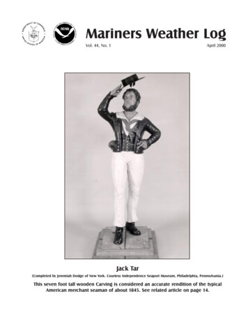
Mariners Weather LogVol. 44, No. 1April 2000Jack Tar(Completed by Jeremiah Dodge of New York. Courtesy Independence Seaport Museum, Philadelphia, Pennsylvania.)This seven foot tall wooden Carving is considered an accurate rendition of the typicalAmerican merchant seaman of about 1845. See related article on page 14.
Mariners Weather LogMariners Weather LogFrom the Editorial SupervisorThe Mariners Weather Log web site now contains sixcomplete issues (including this one), beginning with theAugust 1998 issue. The web site receives the magazineseveral weeks before it is actually in print and containscolor photographs. See web address below.U.S. Department of CommerceWilliam M. Daley, SecretaryNational Oceanic andAtmospheric AdministrationDr. D. James Baker, AdministratorNational Weather ServiceJohn J. Kelly, Jr.,Assistant Administrator for Weather ServicesEditorial SupervisorMartin S. BaronEditorMary Ann BurkeThe Secretary of Commerce has determined that the publication of thisperiodical is necessary in the transaction of the public business required by lawof this department. Use of funds for printing this periodical has been approvedby the director of the Office of Management and Budget through December1999.The Mariners Weather Log (ISSN: 0025-3367) is published by the NationalWeather Service, Office of Meteorology, Integrated HydrometeorologicalServices Core, Silver Spring, Maryland, (301) 713-1677, Ext. 134. Funding isprovided by the National Weather Service, and the National EnvironmentalSatellite, Data, and Information Service Navy. Data is provided by the NationalClimatic Data Center.Articles, photographs, and letters should be sent to:This issue contains a mail-in questionnaire. We wouldgreatly appreciate your cooperation in filling this out andmailing it to us. The business reply form on the back of thequestionnaire is postage free if mailed in the United States.Very Important: Please keep us informed about changes toyour mailing address. Voluntary Observing Ships maycontact any United States Port Meteorological Officer(PMO) to update or change an address.The La Niña phenomenon (cooler than normal water overthe mid Pacific), present for the past two years, is reducingin strength. As it continues weakening, its enhancing effecton hurricane formation in the Atlantic Basin will diminish(La Niña is associated with weaker Atlantic area upperlevel winds [reduced wind shear], a condition favorable fortropical storm development). However, hurricane expertsbelieve that current global atmospheric circulation patternsare still conducive to an above-average Atlantic hurricaneseason in 2000, and total activity is expected to exceed thelong-term annual average of 5.7 Atlantic basin hurricanes.The renowned Colorado State hurricane forecast team iscalling for eight named Atlantic hurricanes in 2000 (therewere eight in 1999 and ten in 1998). Sustained wind mustbe at least 74 mph to qualify as a hurricane. On the otherhand, El Niño years are associated with fewer than normalAtlantic tropical storms (because of greater wind shearaloft). For more information see http://tropical.atmos.colostate.edu/ and http://www.ncep.noaa.gov.Martin S. BaronhSome Important Webpage AddressesMr. Martin S. Baron, Editorial SupervisorMariners Weather LogNational Weather Service, NOAA1325 East-West Highway, Room 14108Silver Spring, MD 20910NOAANational Weather ServiceAMVER ProgramVOS ProgramSEAS ProgramMariners Weather LogPhone: (301) 713-1677 Ext. 134Fax: (301) 713-1598E-mail: martin.baron@noaa.govMarine Dissemination2 Mariners Weather e these webpages for further links.
Mariners Weather LogMariners Weather Log (MWL) Readers QuestionnaireWe want to hear from you!So we can better serve you in the future, please let us know how we’re doing by completing this short questionnaire.Thank you for your feedback.Please rate MWL on the following features:1.What is your favorite column or type of article?o I like them all.o It would have to be this one:2.What’s your least favorite article in MWL?o They’re all good.o It would have to be this one:3.Is the content of MWL relevant and useful?o Strongly Agree o Agreeo Disagreeo Strongly DisagreeEase of reading the articles: (1 poor, 5 excellent)1234oooo5oOrganization/Layout: (1 poor, 5 excellent)123ooo5o4.5.4oo6.How did you first hear about MWL?o Word-of-moutho Libraryo Saw it aboard ship or other place of businesso Article in newspaper/magazineo Search engine on webo Conference/trade showo Other7.Please rank the MWL departments in order of importance: (5 most valuable)12AMVER ArticleooGreat Lakes WrecksooPhysical OceanographyooMarine BiologyooNational Data Buoy CenterooVOS ProgramooVOS Coop. Ship ReportsooBuoy Climatological DataooMarine Weather Review N. AtlanticooMarine Weather Review N. PacificooMarine Weather Review TropicsooClimate Prediction Center ChartsooOn The BridgeooMarine History ArticlesooSpecial Feature articlesooMeteorological Services (Observations)ooMeteorological Services (Forecasts)oo3ooooooooooooooooo8.Overall, how satisfied are you with MWL? (1 poor, 5 excellent)12345ooooo9.How can we improve the MWL?No Opinion4ooooooooooooooooo5oooooooooooooooooThank you for taking the time to complete this questionnaire.April 2000 3
Mariners Weather LogFold Here and Seal with Tape at BottomUS DEPARTMENT OF COMMERCENOAA, NATIONAL WEATHER SERVICE, W/OM121325 EAST-WEST HIGHWAY, ROOM 14108SILVER SPRING MD 20910-3282OFFICIAL BUSINESSPENALTY FOR PRIVATE USE 3004 Mariners Weather Log
Mariners Weather LogTable of ContentsDynamic Fetch: Some Insight Into Rapid Increase in Sea Wave Height . 6The Life of a Sailor: A Collector’s Vision . 14Great Lakes Wrecks: The Loss of the Eastland . 17Rendezvous with Mitch . 75Departments:AMVER . 18Marine Weather Review2000 Hurricane and Cyclone Names . 21North Atlantic, September–December 1999. 23North Pacific, September–December 1999 . 39Tropical Atlantic and Tropical East Pacific, September–December 1999 . 54Climate Prediction Center, September–December 1999 . 73VOS Program . 78VOS Cooperative Ship Reports . 92Buoy Climatological Data Summary . 104Meteorological ServicesObservations . 110Forecasts . 113April 2000 5
Dynamic FetchDynamic FetchSome Insight Into Rapid Increase in Sea Wave HeightMichael CarrMaritime Institute of Technology & Graduate StudiesLinthicum Heights, MarylandEditors Note: The author hasbased this article on researchconducted by Scott Prosise,meteorologist with the NationalWeather Service Marine Prediction Center in Camp Springs,Maryland.On 26 March 1997 meteorologist Scott Prosise wasstanding the eveningwatch at the Marine PredictionCenter in Camp Springs, Maryland, monitoring development of astrong low-pressure systemlocated in the Eastern Pacific.Winds associated with this lowwere increasing rapidly, shown byship reports and readings frombuoy 46003, located off theCalifornia-Oregon coast near thecenter of the low.Scott observed the wind speedassociated with this low increasingfrom gale to storm force in a shortthree-hour period. But what Scottfound most fascinating about thisstorm was the increase in waveheight. During the same three6 Mariners Weather Loghours that winds increased fromGale to Storm force, wave heightincreased by 3 meters (10 feet),from 5.5 to 9 meters (18 to 28feet)!According to guidance providedby the wave development models,the wave height should haveincreased by, at most, 1 to 1.5meters (4 to 5 feet), not by 3meters (10 feet). Scott rememberssaying to himself, “Wow! What isgoing on here?” He was amazed.“I was very anxious to see whatthe next several hours wouldbring.”During the next hour wind speedpeaked at fifty knots and seaheight increased from 9 to 11meters (28 to 35 feet)! “This was atremendous jump,” said Scott,“and I could hardly wait for thenext set of buoy reports.” He wasnot disappointed, for during thefollowing hour seas increasedagain, rising from 12 to 14 meters(37 to 43 feet; see chart for buoy46003 on 26-27 March.Scott was facinated by thisdramatic increase in sea height.During his more than ten years asa marine meteorologist he hadnever seen seas increase sorapidly. He quickly hypothesizedthat some type of “wave front”development was occurringinstigated by a rapidly developinglow pressure system, for whichfew observations were available.Scott searched archived data forrepeats of this rapid wave development to determine if whatoccurred on 26 March was a“fluke” or a valid phenomena. Hesoon found substantiating data.Scott identified ten instances inthe Eastern Pacific during 1997-98where seas associated with stronglow pressure systems increased 3meters (10 feet) in 3 hours, thecriteria he had decided on using todefine rapidly developing seas.One example was a storm thatoccurred off the Oregon coast 18Continued on Page 7
Dynamic FetchDynamic FetchContinued from Page 619 November 1997. Buoy 46002,located 250 miles west of theOregon coast measured an increase in sea wave height from 7to 11.5 meters (22 to 36 feet) intwo hours! Winds during this sameperiod changed little, hoveringaround 50 knots. Wave models allpredicted a sea wave heightincrease from 7 to 8 meters (22 to25 feet) with a maximum significant height of 9 meters (28 feet).The actual height exceeded thepredicted height by 2.5 meters (8feet).After consulting with othermeteorologists and wave modeldevelopers within the MarinePrediction Center, as well asresearchers at the UniversityCorporation for AtmosphericResearch (UCAR), Scott discovered that there was a familiaritywith this rapidly developing seastate phenomenon, and that theterm “Dynamic Fetch” had beenused to describe it. According tothe wave model developers, thewave models can identify Dynamic Fetch conditions andforecast the associated waveheights, but only when enoughaccurate observed data is availableas initial model input. Also, thewave models obtain importantdata from other models, especiallythe Aviation (AVN) model, anddepend on the AVN to accuratelyrepresent various initial meteorological conditions, such as thespeed of movement of weathersystems. Because of the scarcityof observed data over the oceans,the available data as model inputis sometimes insufficient. The twocritical times of day for themodels are 0000 UTC and 1200UTC, when they are initializedwith fresh data to produce newguidance products.3. This rapidly intensifyingstorm is increasing in forwardspeed, which is significantbecause as a storm increasesin speed it can stay in stepwith developing seas.Examination of all available datain the ten incidents he identifiedbrought Scott to conclude thatthese rapid rises in wave heightare brought on by three criticalfactors:These three factors enable waveheight and wave period to steadilyincrease, with no “leveling out” orarrival at a maximum sea height,as would be expected. DynamicFetch allows maximum energyfrom winds associated with astrong low-pressure system tobuild extreme waves, with thesewaves increasing very rapidly inheight. If a swell is already presentin an area of developing seas thisincrease is often accelerated, withbreaking seas occurring wellbefore expected.1. Surface wind speed is equal tothe speed of the wave group.This allows wind to be “insync” or “in-step” withdirection and speed of developing waves, permitting windto quickly and efficientlymove energy into wavedevelopment. Wave groupvelocity is equal to one-halfthe speed of individual waves(we are not measuring thespeed of individual waves, butthe movement of an entirewave train). Individual wavespeed is equal to three timeswave period.2. A rapidly intensifying storm isoccurring on the surface,indicated by a 1 mb per hourdrop in barometric pressureand 100 knot winds within adigging trough (see thebeginning of the monthlyweather review section for adefinition) at the 500-mblevel. (A detailed explanationof rapidly intensifying lows isfound in “Weather PredictingSimplified: How to ReadWeather Charts and SatelliteImages” published by International Marine).Dynamic Fetch is most likely acontributing element in other seasate phenomena such as rogue(freak waves of exceptionalheight) and wave convergence(large seas created when fastermoving waves overtake otherwaves and come into phase withthem). Dynamic Fetch alsoprovides an explanation for wavedevelopment when wave decaywould traditionally be expected. Itis easy to see how Dynamic Fetchfactors into Gulf Stream NorthWall events and other cases wherelarge seas are associated withinteraction of low-pressuresystems and strong ocean currents.Marine Prediction Center meteorologists are now consideringannotating surface weather chartswith the words “Seas RapidlyContinued on Page 8April 2000 7
Dynamic FetchDynamic FetchContinued from Page 7Increasing” when conditionssupporting Dynamic Fetch aredetected. Mariners should add theDynamic Fetch phenomena totheir “weather checklist,” andlearn to recognize the factors thatlead to its occurrence. ThoughDynamic Fetch episodes areunusual events, seasonal in nature,and of short duration, they resultin conditions dangerous to allvessels.Remember to be on the lookoutfor these conditions which maycause seas to build rapidly: arapidly intensifying low, increasing forward speed of the low, andupper-air charts supportingincreasing intensity for the lowpressure system (indicated by adigging, amplifying trough).h8 Mariners Weather LogCharts for period 18-19 November 97: A sequence of 7 surface analysis charts showsa developing storm near 38N/138W at 0000 UTC 18 November, which quickly movesNE and deepens, going from a central pressure of 1005 to 974 mb in 24 hours (a dropof 31 mb in 24 hours). The storm’s strength and rapid movement to the NEsupported dynamic fetch conditions.
Dynamic FetchApril 2000 9
Dynamic Fetch10 Mariners Weather Log
Dynamic FetchCharts for period of 26-27 March 97: A sequence of 3 surface analysis charts shows alow pressure system moving across the north pacific and into the Gulf of Alaska.Dynamic Fetch conditions developed south of low’s center where tight and parallelisobar lines provided the strong, consistent and progressing winds needed for rapid seasstate development.April 2000 11
Dynamic Fetch12 Mariners Weather Log
Dynamic FetchWind Velocity Wave Group VelocityResult: Rapid Wave GrowthDynamic FetchIdentifying Possible Events While At Sea Half the wave period storm (fetch) movement.Rapidly intensifying storm.Well-developed storm increasing in forward speed.Wave period and wave height steadily increasing (short term - not all the time).Effects: Allows maximum energy from the wind field into the building of waves.Wave heights increase rapidly.Creation of a wave front.Enhancement (steepening) of an already established wave front.Characteristics: Unusual – Not a Common EventSeasonal – October through AprilShort Duration – 12 to 18 HoursScale – Small in a Real ExtentApril 2000 13
Life of a SailorThe Life of a Sailor: A Collector s VisionTania KarpinichJ. Welles HendersonIndependence Seaport MuseumPhiladelphia, PennsylvaniaEditors Note: This exhibit is ondisplay at Independence SeaportMuseum through September 2000.It provides thought-provokinginsights and observations aboutthe men and women who chose alife aboard ship during the 18thand 19th century from 1750-1910.The museum is located on thePenn’s Landing Waterfront at 211S. Columbus Boulevard andWalnut Street in Philadelphia.To pursue insights into thelife of the sailor, the exhibitbegins where sailors began,on shore, motivated to sail butreluctant to depart from theirloved ones. It is a story marked byhardship, loneliness, physicallabor, heartache, a zest for life onthe high seas, as well as heartybinges ashore. It is a story of theordinary sailor drawn to distanthorizons, stirred by the romanceof the sea.A broad spectrum of objects suchas hand illustrated diaries, journals, log books, tattoo designs,sketches, models, wood carvings,scrimshaw, uniforms, embroidery,14 Mariners Weather Logphotographs, paintings, prints, andrelated material highlight aspectsof a sailor’s life aboard ship andashore from mid 18th to early 20thcentury. All of the materialsshown in this new exhibit aredrawn from the extensive collection of Philadelphia native, J.Welles Henderson, IndependenceSeaport Museum’s Founder andChairman Emeritus, who has spenta lifetime gathering what isgenerally regarded as the mostcomprehensive treasury of material relating to the life of a sailor.Henderson, a retired lawyer, beganhis collection very early in lifewhen his first precious acquisitionspawned a life-long passion forbuilding a collection of nauticalart, artifacts, journals and documents. As a seven year old in1927, Henderson gave fifty centsto save America’s most historicship, the USS Constitution—“Old Ironsides.” For that donation,Henderson received a smallanchor made of metal and woodsalvaged from the ship.According to Henderson, “Thisevent changed my life. It was as ifI was inoculated with salt water.My quest as a collector had begunfor all things relating to the sea ”As Henderson collected, henoticed that artists in the earlydays of sail generally were notinterested in the life of the common sailor, rather the importantadmirals and naval battles were ofinterest. Expeditions to exotic andremote regions of the world hadartists accompany them, but littleof the everyday life aboard shipwas portrayed. And so the huntbegan, one piece at a time.Today, over 70 years after theacquisition of the anchor, thecollection has flourished. Theexhibit, features 475 maritimeartifacts on display in 42 exhibitcases, many oil paintings, and 90framed visuals including prints,drawings, and watercolor paintings. To convey the flavor and feelof life aboard ship, simple questions that come out of the themesof the gathered materials are posedto the visitor: Why did boys, menand sometimes even women go toContinued on page 15
Life of a SailorThis scene captures a sailor dancing the Hornpipe while a civilian plays the fiddle, to the amusement of five of hisfellow sailors and their lady friends. Painted in 1878 by British artist George Green.The Life of a SailorContinued from Page 14sea? Who exactly were thesepeople of the sea and what sort ofvessels did they sail? How didseamen spend the workday? Whatkinds of tools and instruments didsailors use? What did sailors do intheir idle time? From such questions, the visitor is guided throughan exhibit rich in maritime history,focusing on the sailor as a person.As any collector, Henderson doeshave his favorite pieces that arehighlighted in the exhibit. Welcoming visitors to the exhibit isthe focal piece of his collection,the seven-foot tall Americanwoodcarving, “Jack Tar,” described by experts as one of the100 finest pieces of American folkart (Jack Tar, not an actual person,represented the general sailor ofthe time, who would tar his hatand hair to waterproof them). Alsohighly prized is an oil painting byPhiladelphia painter ThomasEakins, “Rear Admiral Charles D.Sigsbee,” who was captain of theUSS Maine when she blew up inHavana Harbor in 1898. The navalengagement painting by ThomasBirch, “U.S. Frigate UnitedStates defeating HMS Macedonian on October 25, 1812” issignificant to Henderson’s collection as he once loaned it to formerPresident John F. Kennedy fordisplay in the Oval Office at theWhite House during the years1961-1963.The exhibit is based on Henderson’s book, Marine Art andAntiques/JACK TAR/A Sailor’sLife/1750-1910, published byAntique Collector’s Club ofEngland.The book is a complementaryresource for those viewing theexhibit as the storyline and labelsclosely follow the book. Eachchapter focuses on separateaspects of a seaman’s life aboardship and ashore in the age of sailand early steam, and conveys theflavor and feel of life aboard.Searching for the life of a sailorthrough marine art and antiqueswas challenging. But by diligentcollecting over the decades,Welles Henderson has put togethera wide range of materials ofdifferent genres and media thatgive insights into the human sideof the challenge of the sea. Withits depth and breadth, this privatecollection of extraordinary contemporaneous materials offers aremarkably fresh view of thesailor’s life.For more information about theIndependence Seaport Museum,visit http://www.libertynet.org/seaport.hApril 2000 15
Life of a SailorPages from tattoo books like these help identify the popular themes ofthe era. From an American Tattoo Design Book c. 1890.Sailors sewing box decorated with stars, diamonds, hearts, etc. From theprivate collection of J. Welles Henderson.16 Mariners Weather Log
Great Lakes WrecksGreat Lakes Wrecks The Loss of the EastlandSkip GillhamVineland, Ontario, CanadaThe worst marine accidentin the history of theGreat Lakes was thesinking of the steamerEastland dockside at Chicago,Illinois, on July 24, 1915.The vessel was one of severalthat had been chartered to theWestern Electric Company fortheir annual picnic at MichiganCity, Indiana. There were 2,500people on board and they werein a festive mood for theirscheduled afternoon of fun andsun.The Eastland sank on July 24, 1915, while along a dock in Chicago, Illinois.Over 800 people lost their lives.many of the passengers went toBefore Eastland could departthe rail to observe a passingthe dock it rolled over on itssteamer it was enough to causeside, dumping many people intothe disaster.the water and trapping scoresinside the hull.Eastland had been built by theJenks Shipbuilding CompanyFrantic rescue efforts were notand launched at Portenough and between 812 andHuron, Michigan, on May 6,835 people lost their lives.1903. The vessel initiallyoperated between Chicago andThe 265 foot long EastlandSouth Haven, Michigan.was only 38.2 feet wide andcarrying passengers and freight,some believed this caused aparticularly fresh fruit intendency to roll in heavy seas.season. For a time it alsoShe may have become topworked on Lake Erie betweenheavy that fateful day and whenCleveland the resorts at CedarPoint.The sunken hull was refloatedand rebuilt in 1917 for the U.S.Navy. It was used as a trainingship on the Great Lakes duringtwo World Wars and wasknown as the USS Wilmette.The ship was broken up forscrap at Chicago in 1948.Skip Gillham is the author of18 books, most related to GreatLakes ships and shipping.hApril 2000 17
AMVERAMVER Ship Rescues Survivors From Plane s Maiden FlightRick KenneyAMVER Maritime Relations OfficerUnited States Coast GuardEditors Note: This article is takenfrom an account by PA3 EricHedaa, United States CoastGuard.One aspect of AMVER thatis often overlooked is itsusefulness in aviationemergencies over the ocean. Justrecently, AMVER played a keyrole in the rescue of two Australians who survived a plane ditching at sea in the middle of thenight!18 Mariners Weather LogA ferry flight of a brand new, 170,000 single-engine PiperArcher III airplane from VeroBeach, Florida, to Hilo, Hawaii,made an unexpected landing in thePacific Ocean, 305 nm northeastof Hawaii. Pilot RaymondClamback, a flight instructor fromSydney, Australia had made morethan 150 uneventful ocean crossings ferrying planes. He invitedhis friend, Dr. Shane Wiley, alongas company for the ride. The lastleg of the trip would take themfrom Santa Barbara, California, toHilo, Hawaii, a distance of 2,400miles.About 1,700 miles into the trip, anoil pressure light provided the firstclue of a possible problem.Clamback initiated search andrescue procedures by notifying theFederal Aviation Administrationin Oakland, Caalifornia, that heContinued on Page 19
AMVERAMVER Ship Rescues SurvivorsContinued from Page 18was experiencing a potentiallyserious problem. As per procedure, the FAA notified the JointRescue Coordination Center(JRCC) in Honolulu, staffedjointly by the U.S. Air Force andU.S. Coast Guard.Upon notification, the CoastGuard Search and Rescue (SAR)Coordinator’s first reaction was tofind a nearby ship and have theplane ditch close to it, a scenariocalled a “controlled ditch.” TheUSCGC KISKA got underwayfrom Hilo at best speed for arecovery effort. Since it was sucha distance from the flight path ofthe small plane, the JRCC turnedto the Automated Mutual-assistance VEssel Rescue (AMVER)system to locate ships under theplane’s heading. Three ships wereidentified, contacted and requestedto divert and assist. M/V LIHUE,a 720-foot container ship belonging to Matson Navigation of SanFrancisco, was the ship closest tothe plane at that point. Afterpassing on-scene weather conditions to the JRCC, the ship wasasked to stand by as the target forthe controlled ditch.Meanwhile a Coast Guard C-130aircraft was launched from the airstation at Barber’s Point, Hawaii,to rendezvous with, and providean escort for, the disabled aircraft.When he heard the aircraft was enroute, Clamback decided not toditch immediately. Three hourslater, the C-130 was within visualsight of the Piper plane. The pilotsexchanged information on thePiper’s status: oil pressure wascontinuing to drop, but the planewas still flying. There were onlytwo options, fly toward the nearestship and ditch the plane, withpower in daylight; or, try tocomplete the flight and face theworst-case scenario of a poweroff, nighttime ditch at someunplanned point along the route.Commercial airline pilots, listening to the dramatic exchanges asthey flew overhead on their way toand from Hawaii, offered thebenefit of their experiences andencouragement.Clamback decided to roll the diceand gamble that the plane wouldmake it. He and the Coast Guardpilot agreed on emergency contingency procedures, and everyoneheld their breath. At that point, theAMVER ship M/V Lihue wasstood down and released from thecase by JRCC SAR coordinators.Almost 200 miles later, as theplanes flew into a rain squall, aloud banging from the enginesignaled that no oil remained inthe engine and the plane would godown. With radio contact suddenly lost, the C-130’s pilot putthe ditching plan into action,diving below the Piper and aheadof it. In the back of the CoastGuard plane, crewmen begandropping a string of flares tocreate a “runway in the sea” ontop of 10-foot swells.Using the flares as a frame ofreference to judge the plane’saltitude, the Piper plunged into thewater just 30 feet from a flare. Theimpact was substantial, butseatbelts held the two occupants inplace, with no major injuries. Thetwo men climbed out onto one ofthe wings and threw the plane’slife raft into the water, only to findit wouldn’t inflate. The plane sankwithin minutes of impact, and thetwo survivors jumped from thewing into the roiling water, withonly their life jackets as theystruggled against the waves.Unable to find the survivors in thedark and short on fuel, the C-130dropped a data marker buoy anddeparted the scene. Rescuecoordinators sent TELEX messages to the two closest AMVERvessels, asking them to assist. M/V Nyon, a 743-foot bulk carrierbelonging to Suisse-AtlantiqueSociete de Navigation MaritimeS.A. of Lausanne, Switzerland,acknowledged that it had changedcourse and was en route to thescene. In the interim, a second C130 had launched from BarbersPoint and headed for the crasharea. This aircraft came equippedwith night vision goggles (NVGs)Continued on Page 20April 2000 19
AMVERAMVER Ship Rescues SurvivorsContinued from Page 19to assist in the search, and thatproved to be the lifesaver for thetwo survivors.As that C-130 arrived on scene,the rain squall had passed and themoon was now providing optimum visibility. Only ten minutesinto the search, the plane’s dropmaster spotted two traces of lightthrough the NVG’s. The planedropped flares and circled aroundawaiting the arrival of M/V Nyon.The ship, on a voyage from NewOrleans to Inchon, South Korea,was 70 nm from the position ofthe ditch at the time it was contacted by the Coast Guard. Itarrived at 3:15 am and was guidedby the C-130 to the sources of thelight.Lookouts posted on the M/VNYON heard the two survivorsyelling from the water. The ship’smaster reported to the CoastGuard that they heard somebodyscreaming and were maneuveringinto position to pick them up. Thelights ultimately turned out to betwo small personal marker lightsattached to the life jackets. Theship’s crew threw life rings out tothe two exhausted men as theyswam tow
National Weather Service, NOAA 1325 East-West Highway, Room 14108 Silver Spring, MD 20910 Phone: (301) 713-1677 Ext. 134 Fax: (301) 713-1598 . National Data Buoy Center ooooo VOS Program ooooo VOS Coop. Ship Reports ooooo Buoy Climatological Data ooooo Marine Weather Review N. Atlantic ooooo

