Transcription
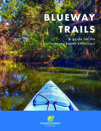
B LU E WAYT R A I LSA guide fo r t hecanoe/kayak enthus ia s t
How to Use This GuideThis guide provides information on the excellentpaddling opportunities in and around CharlotteCounty. Charlotte County’s shoreline is divided intothe following three regions: West County, MidCounty, and East County.Explanation of ClassificationsThese guidelines are for educational purposes onlyand are not intended to provide a basis for evidenceof responsibility or negligence in any legal action. Alluses of the outlined trails are at the users’ own risk.Factors that can change the classification of a trailinclude weather, time of year, time of day, group andindividuals needs.BEGINNER (BEG): Involves gentle paddling in lakes,deltas, creeks and embayments, in inhabited, nonchallenging, protected waterways exposed to slightcurrents or tides. Trips will generally require lessthan two (2) hours of paddling; on-board water isrecommended.INTERMEDIATE (INT): Involves exposure to openwater subject to moderate currents, tides, and wind.Landing areas may be unavailable for up to fivemiles. Moderate hazards may exist such as bottomconditions and unrestricted motorboat traffic. Tripswill generally require less than six (6) hours; onboard food and water is required.EXPERT (EXP): Involves exposure to broad reachesof open water with potential for heavy currents, tides,wind, and surf. Areas may be remote with assistancemore than four hours away and landing areas are notpredictable. Uncharted hazards and conditions mayexist. Trips may exceed eight (8) hours; on-board foodand water required. Thorough knowledge of trail routeand conditions required.1Paddling Safety Tipsand RegulationsSafety equipment to have before hitting the water: Flotation gear; Florida Law requires a Coast Guardapproved, readily accessible and wearable personalflotation device (PFD) for each occupant of the vessel. All occupants under age 6 must wear PFDs. Sound-producing device, such as a whistle, horn or bell. First aid kit; include sunscreen and insect repellent. Extra paddle, bow and stern lines, and extra rope. Hat and sunglasses. Cellular/mobile phone if available.Plan route and allow for enough time: Let someone know where you are going and how longyou expect to be on the water. Allow for a minimum of two miles per hour paddlingtime under normal water conditions for route area. Check recent and predicted weather conditions.Thunderstorms with extreme gusty winds can formquickly in the summer months. Paddling against the tidal flow can be difficult and willexhaust a person’s energy reserves; most of CharlotteCounty’s waters are tidally influenced. Wind direction and speed can also be a factor whenpaddling, especially on wide or coastal rivers. Rivers in south Florida are usually low in the spring andnormal to high in the summer and fall months.On the water: Paddle in a group or with a buddy. Watch for motorboats, wave runners, and jet skis. Stayto the right and turn your bow into the wake. Place food and gear in a water tight container andsecure them tightly to your canoe or kayak. Bring plenty of drinking water for the trip. Wear your life jacket.2
Charlotte County Blueway TrailsHistory of the AreaThe Charlotte County Blueway Trails system is incorporated into the extensive Statewide FloridaGreenways and Trails System, providing for connectivity through an inclusive interconnected network ofgreenways, trails, and waterways. Come and experience the beauty of the barrier islands, tidal creeks,estuary bays, and of course Charlotte Harbor.The archaeological record of Charlotte Harbor dates back some 3,000 years. The area’s first inhabitants weremound builders who constructed numerous shell mounds and established camps along the harbor. The firstEuropean to visit the area was probably Ponce de Leon in the early 1500s. Hernando de Soto is believed bysome historians to have ventured here in 1539, followed by Pedro Menendez D’Aviles in 1556.The Charlotte County Blueway Trails are filled with unique opportunities to observe Southwest Florida’snative flora and fauna. With approximately 219 miles of coastline to explore, paddlers can get away fromthe hurried pace of day-to-day life. Along the western county boundary the Gulf of Mexico connects toan extensive estuarine system including barrier islands, tidal creeks, estuary bays, and Charlotte Harbor.Paddlers can expect to see a variety of coastal habitats including seagrasses, salt marshes, mangroveforests, and riverine communities. Seagrasses are underwater flowering plants found in protected baysand lagoons where water is clear and wave action is moderate. Seagrass beds are of vital importanceto the health of the estuarine waterways by providing lifelong shelter for many species of small fish andinvertebrates. Recreational marine fish species are dependent upon seagrass during their life cycles andseagrasses help to improve water quality by stabilizing bottom sediments.In 1744, English explorer Bernard Romans surveyed the area and named it CharlotteHarbor in honor of Queen Charlotte Sophia, wife of King George III. The United Statestook possession of Florida in 1819.Salt marshes are tidal wetlands that occur along low-energy coastlines and river shorelines; they arecharacterized as expanses of grasses, rushes, and sedges found in the zone between low and high tide.Salt marshes are one of the most biologically productive ecosystems, providing food for many speciesof animals, forming the base of the marsh food web, and serving as a nursery for several species of fish,crabs, and shellfish. Salt marshes also buffer upland areas from storm surge, helping to protect homesand upland development. Mangrove forests, or mangrove swamps, inhabit low energy shorelines incoastal areas and are specially adapted to salt- and brackish-water environments. Mangrove forests arevery high in ecological value and contribute to both the health of our waterways and the local economyby stabilizing shoreline areas, buffering storm surge, preventing erosion, as well as providing nestingsites for shorebirds, and habitat and nursery grounds for many species of fish and invertebrates.In 1862, rangers Joel and Jesse Knight constructed a cattle dock on the northern shoreof Charlotte Harbor. The dock was used by local cattlemen to load their shipments,sold primarily to the Confederate Army. A holding pen, general store, and homes wereconstructed in the area surrounding the dock. This first settlement, which predatedPunta Gorda and Englewood, was known as Live Oak Point, Hickory Bluff, andeventually Charlotte Harbor.Parking PassesParking passes are available for those who frequently visit and enjoy our beautiful Charlotte County beachesand boat ramps. Passes can be purchased by mail, in-person, or online and need to be affixed to the vehicleon the inside front windshield, passenger side, bottom corner. Visit https://tinyurl.com/CharCoParkPass topurchase a parking pass online.Passes may be purchased by mail or by visiting any of the following locations:Ann & Chuck Dever Regional Park Recreation Center, 7001 San Casa Drive, EnglewoodCentennial Park, 1120 Centennial Blvd., Port CharlotteCharlotte County Tax Collector, 18500 Murdock Circle, Port Charlotte (in-person only)Harold Avenue Regional Park, 23400 Harold Ave., Port CharlottePort Charlotte Beach Park, 4500 Harbor Blvd., Port CharlotteSouth County Regional Park, 670 Cooper St., Punta GordaTringali Park, 3460 N. Access Road, EnglewoodPasses are available in three forms:Annual 53.506 Month 37.453 Month 26.7534
West County TrailsInter Coastal Trail (BEG)Stump Pass Trail (BEG)Caution: Trail ObstructionRocky Creek Trail (INT)Access PointOyster Creek Trail (BEG)Boat RampBuck Creek Trail (BEG)Rambler Hole Trail (BEG)Grande Tour Trail (BEG)Coral Creek East Trail (BEG)ALemon Bay Sunrise Rotary RampBAinger Creek Park RampCStump Pass Beach State ParkBeachDOyster Creek Environmental ParkSandEThorton Key Preserve SandFBill Coy Preserve GeowebGDon Pedro State Park Sand51000 S McCall Road, Englewood2011 Placida Road, Englewood900 Gulf Blvd., Englewood2333 Placida Road, Englewood8 Thornton Key Preserve, Englewood5350 Placida Road, Englewood8450 Placida Road, Placida6
Caution: Trail ObstructionAccess PointBoat RampHCentennial Fishing PierIPlacida Park RampJBoca Grande Fishing Pier14021 Gasparilla Road, PlacidaKayak Launch6499 Boca Grande Causeway, Placida5810 Gasparilla Road, Gasparilla IslandSandWest County Trails7Woolverton Trails (BEG)M Cantelas Trail (BEG)Bird Key Trail (BEG)Shallow Water Trail (BEG)Turtle Bay Trail (BEG)Catfish Creek Trail (BEG)Little Gasparilla Trail (BEG)Bull Bay Trail (BEG)Widden Creek Trail (BEG)Turtle Bay Bypass (BEG)Boggess Hole Trail (BEG)Boca Grande Trail (BEG)Bull Bay Bypass (BEG)Sister Ponds Trail (BEG)Cantelas Trail (BEG)8
Mid-County TrailsWest Wall Trail (EXP)Muddy Cove Trail (BEG)Santa Fe Trail (BEG)Ohara Trail (BEG)Trout Creek Trail (INT)Arapahoe Trail (BEG)Cattle Dock Trail (BEG)W Spring Lake Trail (BEG)Upper West Wall Trail (INT)Three Lakes Trail (BEG)Gulf Cove Trail (INT)Myakka Cut Off (INT)Myakka River Trail (INT)Muddy Cove Cut (BEG)Tippecanoe Trail (BEG)Lewis Creek Trail (BEG)Ghost Point Trail (BEG)Alligator Bay Trail (BEG)Muddy Cove Trail (BEG)E Spring Lake Trail (BEG)South Gulf Cove ParkRampEl Jobean Boat RampRampM Tippecanoe Environmental ParkSandN Spring Lake ParkRampO William R. Gaines Veterans Jr. Memorial ParkSandPort Charlotte Beach ParkBeachKL10150 Amicola St., Port Charlotte4224 El Jobean Road, Port Charlotte2400 El Jobean Road, Port Charlotte3520 Lake View Blvd., Port Charlotte20499 Edgewater Drive, Port CharlotteCaution: Trail Obstruction9P4500 Harbor Blvd., Port CharlotteAccess PointQ Bayshore Live Oak ParkSandBoat RampR Chester Roberts ParkSand23157 Bayshore Road, Port Charlotte5084 Melbourne St., Punta Gorda10
Mid-County TrailsHarbour Heights Trail (BEG)Prairie Creek Trail (BEG)QBayshore Live Oak ParkSandUHathaway ParkRampLong Lake Trail (BEG)Upper Shell Creek Trail (INT)RChester Roberts Park SandVRiverside ParkRampSouth Long Lake Trail (BEG)Shell Creek Trail (INT)SHarbor Heights Park RampWDarst ParkRampOuter Shell Creek Trail (BEG)Tranquility Island Trail (BEG)TPraire Creek Preserve AccessXLaishley Park Municipal MarinaRamp23157 Bayshore Road, Port Charlotte5084 Melbourne St., Punta Gorda27420 Voyageur Drive, Punta Gorda1900 Duncan Road, Punta GordaROW35461 Washington Loop Road, Punta Gorda8120 Riverside Drive, Punta Gorda537 Darst Ave., Punta Gorda120 Laishley Ct., Punta GordaCaution: Trail ObstructionAccess PointBoat Ramp1112
South County TrailsTranquility Island Trail (BEG)Dead Lake Trail (INT)Barge Canal Trail (INT)Explorer Trail (INT)North Fork Trail (BEG)Alligator Creek Trail (BEG)Gaspar Trail (INT)East Wall Trail (EXP)Mosquito Trail (INT)Spider Trail (INT)WDarst Park Ramp537 Darst Ave., Punta GordaXLaishley Park Municipal MarinaYPonce de Leon Park RampCaution: Trail ObstructionZAllaptchee Shores ParkAccess PointAA13120 Laishley Ct., Punta GordaRamp3400 Ponce de Leon Pkwy, Punta Gorda3100 Hickory Ct., Punta GordaRampTaylor Rd. Access RoadsideBoat RampTaylor Road, Punta Gorda14
BWT We bs iteCharlotte County Community Services1120 Centennial Blvd., Port Charlotte, FL 33948941.625.PLAY (7529)CharlotteCountyFL.gov
BEGINNER (BEG): Involves gentle paddling in lakes, deltas, creeks and embayments, in inhabited, non-challenging, protected waterways exposed to slight . currents or tides. Trips will generally require less . than . two (2) hours. of paddling; on-board water is . recommended. EXPERT (EXP):