Transcription
International Specificationfor Control DescriptionsINTERNATIONAL ORIENTEERING FEDERATION2018
INTERNATIONAL ORIENTEERING FEDERATIONInternational Orienteering FederationDrottninggatan 47, 3 1/2 tr.SE-65225 KarlstadSwedenhttp://www.orienteering.orgIOF RULES COMMISSION:David Rosen (chairman), Barry McCrae, Felix BüchiEditor:Barry ElkingtonArtwork based on the 1990 edition with additional drawings by Matthew Cook (2004, 2018).Map sections by Jukka Liikari.Layout: Martin Hammarberg, Adshape AB.IOF Control DescriptionsMajor Changes to the 2004 version:1)2)3)4)5)Optional extra line showing the distance to the start triangle from the timed start.New symbols introduced for Trench, Out of Bounds Area.Bend moved from Column G to Column F.Removal of symbol for Radio or TV control.Names and descriptions brought into line with the ISOM 2017 terminology where appropriate.6) Renumbering of symbols to cater for additions and deletions.7) A number of minor changes throughout the text in order to provide further clarification asto the use of specific symbols.8) Minor changes to a number of the examples2International Specification for Control Descriptions - 2018
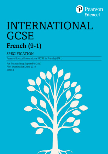
IntroductionOrienteering is a worldwide sport. It is the aim of the IOF control description symbols toprovide a standard means for orienteers from all countries to be able to understand controldescriptions without ambiguity or the need for language translation. This booklet showshow the symbols can be used to do this.How IOF control descriptions workThe purpose of a control description is to give greater precision to the picture given by themap of the control feature, and to indicate the location of the control flag in relation to thisfeature, thereby helping the competitor to better visualise the control site.However, a good control is found primarily by map reading. Descriptions and codes can assistin this task, but: for Foot orienteering these should be kept as short and simpleas is necessary to locate the control. for TrailO, the descriptions may need to be more precise.Note: Control descriptions should not be used to correct map errors.Sample control description sheetIOF Event ExampleClasses M45 M50 W21Course number 5Length 7.6 kmHeight climb 210 mDistance to Start Triangle 150 mStartRoad, wall junction1101Narrow marsh bend2212North western knoll,1m high, east side3135Between thickets4246Middle depression, east part5164Eastern ruin, west sideFollow taped route 120 m away from control6185Stone wall, ruined, south east corner (outside)7178Spur, north west foot8147Upper cliff, 2m high9149Path crossingFollow taped route 250 m from last control to finishInternational Specification for Control Descriptions - 20183
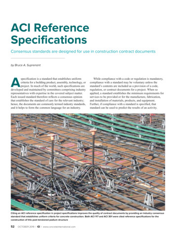
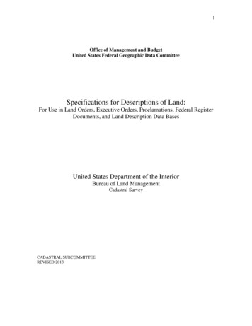
Control description sheet formatThe control description sheet for an orienteering course contains the following information: Heading. Start Location, including details of the distance to the start triangle from the point ofthe timed start if these are not within a few metres of each other. Description of individual controls, incorporating any special instructions such as thelength and nature of any marked route during the course. Nature of route from the last control to the finish.When printed, the description sheet boxes should be square, with a side dimension ofbetween 5mm and 7mm.When control descriptions are provided in a written form the overall presentation should besimilar to that of the pictorial version, and the description of the individual controls written,as far as possible, in the same order as for the pictorial version.HeadingEvent title.Classes (optional line).Course code; Course length in kilometres to the nearest 0.1km, measured from the pointat which the timing starts; Height climb in metres to the nearest 5m.Start locationShown in the first line of descriptions, using the description as if it were a control feature.Optionally this may be preceded by a line showing the distance to the location of the starttriangle from the timed start if these are not within a few metres of each other.Description of individual controlsThese are normally in the order in which they are to be visited, and may incorporate specialinstructions such as the length and nature of any marked route during the course. A thickerhorizontal line should be used after every third description and on either side of any specialinstruction.A4BCDEFGHAControl numberBControl codeCWhich of any similar featureDControl featureEAppearanceFDimensions / Combinations / BendGLocation of the control flagHOther informationInternational Specification for Control Descriptions - 2018
Explanation of ColumnsEach control is described in the following manner:Column A - Control numberNumbering of controls is in the sequence they are to be visited, unless the description isfor a Score competition in which case this column is usually either left blank or indicatesthe control value.Column B - Control codeThe control code should be a number greater than 30.Column C - Which of any similar featureThis column may be used when there is more than one similar feature within the controlcircle; e.g. south eastern.Column D - Control featureThe feature, as shown on the map, at the centre of the circle defining the control site; e.g.clearing; boulder. Most of these are cross referenced to the ISOM 2017 (International Specification for Orienteering Maps) symbol used to represent them.Column E - AppearanceFurther information on the nature of the feature if it is required; e.g. overgrown; ruined.In certain circumstances also used for a second control feature where the description requires this i.e. crossing; junction; between.Column F - Dimensions / Combinations / BendDimensions of the feature should be given where the size of the control feature on the mapis symbolic rather than to scale.Also used for the two combination symbols (crossing; junction), and the Bend symbol.Column G - Location of the control flagPosition of the control flag with respect to the feature; e.g. west corner (outside); southfoot.Column H - Other informationOther information that may be of importance to the competitor; e.g. first aid; refreshments.Special InstructionsThese lines go in the body of the descriptions and give specific information about the natureof the route that must be followed at that point; e.g. follow taped route for 50m away fromthe control; use mandatory crossing point.Nature of route from the last control to the FinishThis line shows the distance from the last control to the finish, and the nature of any tapedroute at the finish.International Specification for Control Descriptions - 20185
Explanation of SymbolsWhere an ISOM reference number is given this shows the relationship to the map symbolas defined in the ISOM 2017 specifications.Column C - Which of any similar featureThese symbols need only be used when required to clarify on which of several similar features the control flag is placed i.e. the features are close enough on the map such that theintended feature is not obvious. They are not required if, for example, a second feature liesnear the edge of the control circle.Ref.Symbol0.1NameDescriptionNorthernThe more northern of two similar features, or thenorthern-most of several similar features.South eastern The more south eastern of two similar features, orthe south-eastern-most of several similar features.0.20.30.40.5UpperWhere the control feature is directly above a similar feature.LowerWhere the control feature is directly below a similarfeature.MiddleWhere the control feature is the middle one of anumber of similar features.Column D – The Control FeatureColumn D indicates the feature on which the control flag is placed.If a second control feature is required (i.e. for crossing; junction; between) then this mustgo in column E. It is not permitted to place two symbols in Column D.Landforms (ISOM section erraceA level area on a slope.101SpurA contour projection or “nose” risingfrom the surrounding ground.101Re-entrantA contour indentation; a valley; theopposite of a spur.101Earth bankAn abrupt change in ground level whichcan clearly be distinguished from itssurroundings.104QuarryGravel, sand or stone working in flat orinclined ground.104International Specification for Control Descriptions - 2018
1.61.71.81.91.10Earth wallA narrow wall of earth projecting abovethe surrounding terrain; may be partiallystone faced, usually man-made.105106Erosion gullyAn erosion gully or trench, normally dry.107Small erosion A small erosion gully or trench, normallygullydry.108HillA high point. Shown on the map withcontour lines.101KnollA small obvious mound or knoll.1091101.111.121.131.141.151.16SaddleThe low point between two higherpoints.101DepressionA depression or hollow from which theground rises on all sides. Shown on themap with contour lines.101SmalldepressionA small, shallow, natural depression orhollow from which the ground rises onall sides.111PitA pit or hole with distinct steep-sides.Usually man made. Used with symbol8.6 to indicate a rocky pit.112203BrokengroundClearly disturbed ground with features113too small or too numerous to be mapped114individually; including animal earths.Ant hill (termite mound)The mound made by ants or termites.Rock and boulders (ISOM section , CragA cliff or rock face. May be passable orimpassable.201202Rock PillarA high, natural rock projection.206CaveA hole in a rock face or hill side, oftenleading to underground workings.203BoulderA prominent free-standing block of rockor stone.204205International Specification for Control Descriptions - 20187
2.52.62.72.82.92.10Boulder fieldAn area covered by so many bouldersthat they cannot be individually mapped.208209BoulderclusterA small distinct group of boulders soclosely clustered together that theycannot be individually mapped.207Stony groundAn area covered with many smallstones or rocks.210211212Bare rockA runnable area of rock with no earth orvegetation cover.214NarrowpassageA gap between two cliffs or rock facesthat face each other.201202TrenchA rocky or artificial trench.215Water and marsh (ISOM section 3.3)Ref.NameDescriptionISOMLakeA large area of water, normally mappedas uncrossable.301PondA small area of water, may be shallow or 302seasonal.WaterholeA water-filled pit or depression.3033.4River,Stream,WatercourseA natural or artificial watercourse witheither moving or standing water.3013043053.5Minor waterchannel,DitchA natural or man made minor waterchannel which may contain water onlyintermittently.3063.6Narrow marsh A narrow marsh or trickle of water, toonarrow to be shown on the map with themarsh symbol.309MarshA permanently wet area with marshvegetation.307308Firm groundin marshA non-marshy area within a marsh, orbetween two marshes.307308WellA shaft containing water or a captivespring, clearly visible on the ground. Oftenwith some form of man-made surround.3113.13.23.33.73.83.98SymbolInternational Specification for Control Descriptions - 2018
3.103.11SpringThe source of a watercourse with adistinct outflow.312Water tank,Water troughA man made water container.311Vegetation (ISOM section 3.4)Ref.SymbolNameDescriptionISOMOpen landAn area with no trees. Grassland, ameadow or a field.4014034.1Also heath or moorland.Semi-openlandAn area of open land with scatteredtrees or bushes.Forest cornerThe corner or tip of a forested areaprojecting into open land.ClearingA small area of land free from treeswithin the forest.401403ThicketA small area of forest where the tree coveror undergrowth is so dense that it is difficultto pass. May also be used for an individualbush (typically in Sprint competitions).408410411Linear thicketA man-made line of trees or bushes that 410is difficult to cross. May also be used for 411a hedge (typically in Sprint competitions).VegetationboundaryA distinct boundary between differenttypes of trees or vegetation.416CopseA small area of trees in open ground.4054064.9ProminenttreeAn unusual or prominent tree ineither open land or forest; frequentlyinformation is also given as to its type.4174184.10Root stock,Tree stumpThe upturned root of a fallen tree, withor without the trunk.4.24.34.44.54.64.74.8402404The stump of a tree.International Specification for Control Descriptions - 20189
Man-made features (ISOM section ISOMRoadA metalled/asphalt surfaced or dirt road,suitable for vehicles in normal weatherconditions.502503Track / PathA visible route made by people or animals.Tracks may be driven by rugged vehicles.504507RideA forest ride or a prominent tracethrough the terrain which does not havea distinct runnable path along it.508BridgeA crossing point over a watercourse orother linear feature.512Power lineA power or telephone line, cableway orski lift.510511Power linepylonA support for power or telephone line,cableway or ski lift.510511TunnelA way under roads, railways, etc.512WallA wall wall of stone or other materials.5135155.8Used with symbol 8.11 to indicate aruined wall.Fence5.95.105.115.125.135.145.155.1610A wire or wooden boundary.Used with symbol 8.11 to indicate aruined fence.514516518517CrossingpointA way through or over a wall, fence, or otherlinear feature, including a gate or stile.519BuildingA standing brick, wood or stonestructure.521Paved areaAn area of hard standing used forparking or other purposes.501RuinThe remains of a building that has fallendown.523Pipeline;bobsleigh/skeleton trackA prominent line feature such as a pipeline(gas, water, oil, etc.) or a bobsleigh/skeleton track which is above ground level.528529Tower / PylonA metal, wooden or brick tower or pylon.524525ShootingplatformA structure attached to a tree where amarksman or observer can sit.525International Specification for Control Descriptions - 2018
5.175.185.19Boundarystone, CairnA man made stone or pile of stones. Acairn, memorial stone, boundary stoneor trigonometric point.526Fodder rackA construction for holding feed foranimals.527CharcoalburninggroundThe clear remains of an area wherecharcoal was burned.530Platform5.205.215.225.23A small level man made area on a slope(a platform).115Monument orStatueA monument, memorial or statue.530531CanopyAn accessible area with a roof. A canopy ora covered passageway through a building.522StairwayA stairway of at least two steps.Out ofBounds areaOut of Bounds area. Typically a flowerbed or similar feature.520Prominent features / Special eature /Special itemIf used, an explanation of its meaningmust be supplied to competitors in thepre-race information.115313419531Prominentfeature /Special itemIf used, an explanation of its meaningmust be supplied to competitors in thepre-race information.115313530Country Specific featuresIt is not generally recommended to introduce local symbols.At events likely to attract an international entry, if local symbols are used then informationabout them must be supplied to competitors in the pre-race n of feature.International Specification for Control Descriptions - 2018ISOM11
Column E - AppearanceThese symbols can be used when required to add clarity to the map in order to allow thecompetitor to better visualise the control NameDescriptionLowWhere the control feature is particularly low or flatbut this is not indicated on the map; e.g. Hill, low.ShallowWhere the control feature is particularly shallowbut this is not indicated on the map; e.g. Reentrant, shallow.DeepWhere the control feature is particularly deep butthis is not indicated on the map; e.g. Pit, deep.OvergrownWhere the feature is partially covered inundergrowth or bushes that are not indicated onthe map; e.g. Ruin, overgrown.OpenWhere the feature is in an area where the treecover is less than the surroundings but this is notindicated on the map; e.g. Marsh, open.Rocky, StonyWhere the feature is in an area of rocky or stonyground not indicated on the map; e.g. Pit, rocky.MarshyWhere the feature is in an area of marshy groundnot indicated on the map; e.g. Re-entrant, marshy.SandyWhere the feature is in an area of sandy ground;e.g. Spur, sandy.Needle leaved Where the tree or trees associated with thecontrol feature have needle shaped leaves; e.g.Prominent tree, needle leaved.Broad leavedWhere the tree or trees associated with the controlfeature are broad-leaved; e.g. Copse, broad leaved.RuinedWhere the feature has fallen to ground level; e.g.Fence, ruined.Column F – Dimensions / Combinations / BendDimensionsNote: The dimension(s) of the feature(s) must be given when they add clarity to the map inorder to allow the competitor to better visualise the control site; e.g. from a visibility pointof view it is important to know if a boulder is 1m high or 3m high.12International Specification for Control Descriptions - 2018
eight orDepthHeight or Depth of the feature in metres.SizeHorizontal dimensions of the feature in metres.Height onslopeHeight of the feature on a slope in metres.Heights oftwo featuresHeights of two features with the control betweenthem.NameDescriptionCrossingThe point at which two linear features cross.JunctionThe point at which two linear features meet; orwhere a linear feature meets the side or edge ofan areal feature.CombinationsRef.Symbol10.110.2When either of these symbols is used in Column F the two features which either cross ormeet must be shown in columns D and E. For example:DEFPath crossingThe point at which two similar linearfeatures cross.Ride / StreamcrossingThe point at which two differentlinear features cross.Road junctionThe point at which two similar linearfeatures meet.Stream / Narrowmarsh junctionThe point at which two differentlinear features meet.Fence / BuildingjunctionThe point at which a linear featuremeets the side of an areal feature.BendRef.11.1SymbolNameDescriptionBendUsed where a linear feature makes a smoothchange of direction; e.g. Path bend; River bend.International Specification for Control Descriptions - 201813
Column G - Location of the control flagNote: No symbol is required to describe the location of the control flag in relation to thefeature if the control flag is positioned at, or as near as possible to, the centre of the feature(or the centre of the foot in the case of the cliff).Ref.SymbolNameDescriptionNorth eastSideUsed where:12.1a) The feature extends above the surface of theground; e.g. Boulder, north east side; Ruin, westside. A control on the side of a raised feature willnot usually be visible from the opposite side.b) The control is located on a linear feature butnot at a corner, e.g. Track, east side; Streambend, south west side.South eastEdge12.2Used where:a) The feature extends down from the surface ofthe surrounding ground and the control is situatedon the edge at ground level; e.g. Depression,south east edge.b) The feature extends over a significant area andthe control is situated on the border of that area;e.g. Marsh, west edge; Clearing, north west edge.West PartUsed where the feature extends over a significantarea and the control is located neither at thecentre, nor on any of the edges; e.g. Marsh, westpart; Depression, south east part.East Corner(inside)Used where:12.312.4South Corner(outside)12.5a) The edge of a feature turns through an angleof 45-135 degrees; e.g. Open land, east corner(inside); Ruin, north west corner (outside).b) A linear feature turns a corner; e.g. Fence,south corner (inside); Stone wall, south westcorner (outside).Note: The side of a building may be treated asa linear feature and hence “building, east corner(inside)” does not mean “inside the building”.The orientation of the symbol indicates the direction in which the corner points.12.614South westTipUsed where the edge of a feature turns throughan angle of less than 45 degrees; e.g. Marsh,south west tip.International Specification for Control Descriptions - 2018
12.712.812.912.1012.1112.1212.1312.14North westEndThe point at which a linear feature ends or starts;e.g. Ride, north west end; Stone wall, south end.Upper PartWhere the feature extends over two or morecontours and the control is located near the top;e.g. Erosion Gully, upper part.Lower PartWhere the feature extends over two or morecontours and the control is located near thebottom; e.g. Re-entrant, lower part.TopWhere the control is located at the highest point ofthe feature and this is not the default location; e.g.Cliff, top; Stairway, top.Foot(no direction)Where the control is located at the lower junctionof the slope of the feature and the surface ofthe surrounding area and this is not the defaultlocation; e.g. Earth bank, foot; Stairway, foot.North eastFootAs above, but where the feature is large enoughfor the control to be placed in more than onelocation around it; e.g. Hill, north east foot.BeneathWhere the control is located underneath thefeature; e.g. Pipeline, beneath.BetweenWhere the control is located between two features;e.g. Between thickets; Between boulder and knoll.When symbol 12.14 ‘Between’ is used in Column G, the two features which the control isbetween must be shown separately in columns D and E. For example:DEFGBetween thicketsThe point between twosimilar features.Between boulderand knollThe point between twodifferent features.International Specification for Control Descriptions - 201815
Column H - Other informationRef.SymbolNameDescriptionFirst Aid postControl site where First Aid is available.13.2RefreshmentpointControl site where Refreshments are available.13.3MannedcontrolManned control site.13.1Distance from Timed Start to the Start TriangleThis is an optional line showing the distance to the start triangle from the point of the timedstart. This will typically be required for an arena start, or when there is a long run out to thestart triangle. It is not required if the start triangle is near to the point where the timing starts.Ref.SymbolName/DescriptionDistance to the start trianglefrom the point of the timedstart.14.1Special InstructionsSpecial instructions may be given to the competitors within the body of the descriptionsheet. These should be used to emphasise what is shown on the map.If a marked route is to be followed away from a particular control, or between controls:Ref.SymbolName/Description15.1Follow Taped Route, 60maway from control.15.2Follow Taped Route, 300mbetween controls.If there are mandatory crossing points or routes between two controls:Ref.16SymbolName/Description15.3Mandatory crossing point orpoints.15.4Mandatory passage throughout of bounds area.International Specification for Control Descriptions - 2018
At a map exchange, or if a marked route is to be followed from a control to a map exchange,it should follow the last control description of the first part of the course as follows:Ref.SymbolName/DescriptionFollow Taped Route, 50m toMap Exchange.15.5Nature of route from the last control to the FinishFollowing the final description, the nature of the route from the last control to the finish isindicated by one of the following:Ref.Symbol16.1Name/Description400m from last control toFinish.Follow taped route.16.216.3150m from last control toFinish.Navigate to finish funnel, thenfollow tapes.380m from last control toFinish.Navigate to finish. No tapes.International Specification for Control Descriptions - 201817
ExamplesMap18TerrainControl DescriptionsText Description1Terrace2Terrace, westpart3Spur4Spur, upper part5Spur, lower part6Re-entrant7Re-entrant,upper part8Re-entrantInternational Specification for Control Descriptions - 2018
MapTerrainControl DescriptionsText Description9Eastern re-entrant10Earth bank, foot115x5Quarry, 5m x 5m12Quarry, eastedge13Quarry, east part14Earth wall,east end15Gully, lower part16Small gully,north-east end17HillInternational Specification for Control Descriptions - 201819
MapTerrainControl DescriptionsText Description18Hill,north-west part19West Hill, eastside20Between hilland knoll211Knoll, 1m221Knoll, 1m,east foot23Saddle24Depression25Depression,east part26Middle smalldepression,east edge27201Pit, 1m deep,west edgeInternational Specification for Control Descriptions - 2018
MapTerrainControl DescriptionsText Description281Ant hill, 1m,south east side292Cliff, 2m302Cliff, 2m, northfoot312Upper cliff, 2m321.5Cliff, 1.5m, top33Between cliffs34Rock pillar,south foot35Cave36International Specification for Control Descriptions - 20181.5Boulder, 1.5m,west side21
MapTerrainControl DescriptionsSouth-easternboulder, 2m,east side3723811.5Between boulders 1m and1.5m390.53Boulder,0.5m/3m, westside40Boulder field,south-east edge41Boulder cluster,south side42Stony ground,north edge4322Text DescriptionBare rock44Bare rock,west part45Narrow passageInternational Specification for Control Descriptions - 2018
MapTerrainControl DescriptionsText Description46Lake, east tip47Pond, east edge48Waterhole,east edge49Stream bend,west side50Southernstream bend,south side51Stream junction,north side52Ditch,north-east end53Ditch bend,west side54Northernditch bend55Ditch junction,north sideInternational Specification for Control Descriptions - 201823
MapTerrainControl Descriptions56Ditch crossing57Narrow marsh,south-east end58Marsh,north-west part59Marsh, south tip60Marsh, eastedge6124Text Description8x8Marsh, 8m x 8m62Between marshes63Firm ground inmarsh,north-west tip64Well, east sideInternational Specification for Control Descriptions - 2018
MapTerrainControl DescriptionsText Description65Spring, westedge66Water tank,east side67Open land, eastcorner (inside)68Open land,sandy west edge69Semi-open land,east edge70Forest corner,south tip71Clearing72Thicket, eastside73Linear thicket,east corner(outside)International Specification for Control Descriptions - 201825
Map26TerrainControl DescriptionsText Description74Vegetationboundary,east corneroutside)75Copse, west tip76Prominent tree,broad leaved,east side77Root stock,east side78Road,south-east end79Road junction,west side80Road/pathcrossing,west side81Path bend,west side82Westernpath bendInternational Specification for Control Descriptions - 2018
MapTerrainControl DescriptionsText Description83Path junction84Path crossing85Path/streamcrossing,north side86Path/ditchcrossing,west side87Ride bend,west side88Bridge, north end89Power line,pylon, west side90Tunnel,south-west end91Wall, east corner(inside)International Specification for Control Descriptions - 201827
Map28TerrainControl DescriptionsText Description92Wall, ruined,west end93Stream/wallcrossing,west side94Path/wall crossing, west side95Fence, southcorner (outside)96Crossing point,south west side97Building, eastside98Ruin, west side99Pipeline, beneath100Tower, southsideInternational Specification for Control Descriptions - 2018
MapTerrainControl DescriptionsText Description101Shooting platform, west side102Cairn, east side103Fodder rack,south west side104Statue, east side105Charcoal burningground / platform106Canopy, southwest end107Stairway, foot108Trench bend109Flower Bed,south corner(outside)International Specification for Control Descriptions - 201829
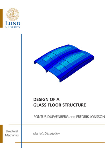
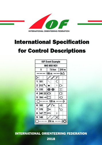
Specifications forTrail OrienteeringThere are two variations in the use of the columns when using IOF Control Descriptionsfor Trail Orienteering.Column B - Number of control flagsThis column is used to denote the number of control flags visible at this control; e.g. A-Cequals three control flags to choose from; A-D equals four control flags to choose from.Column H - Direction of observationThis column is used to denote the direction in which the flags are viewed from the decisionpoint. For example an arrow pointing north indicates that the decision point is located ona path/track to the south of the flagsExample30AB1A-DCDEFGHInternational Specification for Control Descriptions - 2018
NotesInternational Specification for Control Descriptions - 201831
INTERNATIONAL ORIENTEERING FEDERATIONDrottninggatan 47, 3 1/2 tr.SE-65225 KarlstadSwedene-mail: iof@orienteering.orgwww.orienteering.org
The purpose of a control description is to give greater precision to the picture given by the . map of the control feature, and to indicate the location of the control flag in relation to this feature, thereby helping the competitor to better visualise the control site. However, a good control is found primarily by map reading.